
North Truro Air Force Station Radar Site, Truro Massachusetts
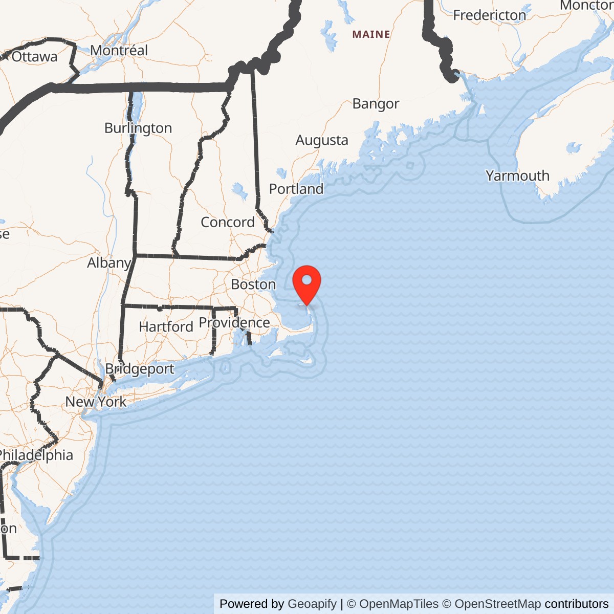
Longitude: -70.054167
Site Number: P-10 / Z-10 / J-53
Official Base Website: Highlands Center / North Truro FAA Joint Surveillance System Site J-53
Current Role: Divided federal use. Approximately 110 acres of former station property are managed by Cape Cod National Seashore as the Highlands Center for park, science, arts, education, and partner functions; general public access is closed except for announced Payomet summer events. The FAA operates an approximately 15.93-acre long-range radar parcel for civil air traffic and the FAA-Air Force Joint Surveillance System. The separate former GATR tract is the active LFV Marconi VOR/DME.
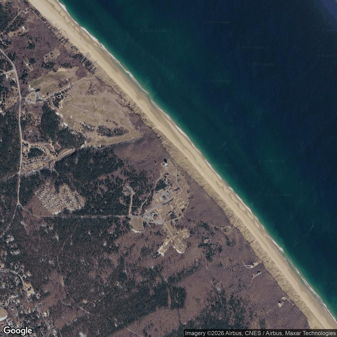
North Truro Air Force Station occupied an exposed Atlantic bluff in Truro, Massachusetts, near the outer end of Cape Cod. From 1951 through June 14, 1985, it served the continental air-defense system as a permanent-network radar station, ground-controlled interception post, SAGE reporting site, Backup Interceptor Control center, operational parent of Texas Tower No. 2, and later contributor to the joint Federal Aviation Administration and Air Force surveillance network. Its radars watched the ocean approaches to Boston and the northeastern United States, while its controllers, computers, communications, and support facilities linked coastal detection to interceptor action.
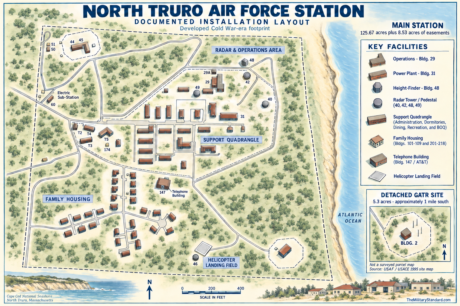
The installation was more than a group of radar towers. At its developed peak it included an operations area, administration and dormitory buildings, dining and recreation facilities, a self-contained power plant, water and sewage systems, maintenance shops, family housing, a guarded telephone switching building, and facilities supporting offshore helicopter and logistics activity. A separate 5.3-acre Ground-Air Transmit-Receive site stood about one mile south. Three remote AN/FPS-14 gap fillers at Westboro, Massachusetts, Fort Dearborn, New Hampshire, and Chilmark, Massachusetts, extended low-altitude coverage where terrain and radar horizon limited the main station.
Closure did not end radar use at North Truro. The Air Force deactivated the staffed station in 1985, retained a small height-finder contingent until 1987, and transferred long-range search operation to the FAA under the Joint Surveillance System. Approximately 110 acres passed to the National Park Service in 1994 and became the Highlands Center at Cape Cod National Seashore. An FAA radar parcel continues the surveillance mission, while the former GATR tract was cleared and replaced by an unmanned VORTAC navigation facility. Thus the historical Air Force installation is closed, but federal aviation and military surveillance functions remain active on portions of the former property.
Identity, Names, and Site Codes
The official historical name is North Truro Air Force Station. Contemporary and later records also use North Truro AFS, North Truro Radar Station, North Truro FAA Radar Site, and, for the National Park Service reuse area, Highlands Center. The permanent Air Force site carried ADC identifier P-10 and later Z-10. The continuing joint-surveillance location is commonly identified as J-53. These codes describe successive operational systems at the same principal radar locality, but they do not include every physically separate annex.
Boundaries, Acreage, and Property Components
The 1995 Air Force-sponsored historical and architectural report gives the main station as 125.67 acres, excluding 8.53 acres of easements. It separately identifies a 5.3-acre GATR tract approximately one mile south. Within the 125.67-acre main station, the developed layout included an operations base and a ten-acre family-housing area.
Later disposition figures answer different questions. The National Park Service states that approximately 110 acres were conveyed to Cape Cod National Seashore in 1994. The 1995 report says that approximately 15.93 acres in the northeastern corner had recently transferred to the FAA for Joint Surveillance System use, although the first digit is imperfect in the scanned text. The NPS and FAA figures plausibly account for most of the former main station, but they are approximate transfer-era areas rather than a new survey of the 125.67-acre Air Force reservation.
The separate GATR tract requires its own permanent record because it was not merely a room in the main operations building. The Air Force acquired and operated a 5.3-acre communications site about one mile south, on a bluff overlooking the ocean, with GATR equipment in Building 2. Modifications there were essential to North Truro's transition to BUIC III in 1968. The FAA demolished the GATR facility in the early 1990s and erected an unmanned navigation facility on the tract. Current FAA data identifies it as the LFV Marconi VOR/DME at 42.0171878 north and -70.0372325 west.
Coastal Geography and Earlier Army Use
North Truro's location near the outer tip of Cape Cod gave it a nearly unobstructed view across the Atlantic. The high coastal bluff minimized nearby terrain masking and placed the radar seaward of most metropolitan clutter. From this position, surveillance could cover approaches toward Boston and southern New England and overlap stations farther north, west, and south. The same location imposed severe salt-air corrosion, wind, fog, sand movement, winter weather, and isolation, making dependable utilities, maintenance, communications, and personnel support part of the operational mission.
The site had a military history before the Air Force. During World War II, Army coast-artillery personnel used the area for antiaircraft training. The 1995 architectural study identified two gun emplacements dug into the bluff above the beach and reported two additional probable positions farther inland. The Army erected five buildings, with a small cantonment centered on Buildings 2 through 5 and a magazine in Building 26 closer to the beach. Later Air Force development altered the property, but this Army phase explains why the location was already recognized as useful for coastal defense.
The Army activity and the later radar station were successive uses, not a single continuously operating installation. World War II training prepared gun crews to engage aircraft visually and with the fire-control methods then available. The postwar Air Force selected the same commanding ground for electronic detection and direction across a far larger area. The common purpose was defense of the coast, but the organizations, real-property programs, equipment, and tactical concepts were different.
Permanent-Network Selection and Construction
Postwar demobilization left the United States with inadequate electronic warning against a long-range bomber attack. Early plans for an extensive radar fence were reduced by cost and rapidly changing technology, but the Soviet atomic test announced in September 1949 and the Korean War sharply increased urgency. The Air Force's permanent network placed radar stations around strategic regions and along the northern and coastal approaches, supported by interim Lashup sites while permanent facilities were completed.
The Air Force acquired the North Truro property in 1948. Construction probably began in early 1949 under Army Corps of Engineers supervision. On December 2, 1949, the Air Force directed the Corps to proceed with the first twenty-four priority permanent radar stations, a group that included North Truro. The site was therefore part of the earliest permanent-network construction effort, not a later mobile deployment or improvised annex.
Construction had to produce an operating community as well as radar foundations. Contractors built operations and communications structures, barracks, administration, dining, maintenance, power, water, sewage, roads, and security facilities. The first personnel arrived before the complex was finished and guarded the site while Air Materiel Command and contractors installed radar and communications equipment. By June 1951, eighteen officers and 173 airmen were living at North Truro, showing how quickly the station grew from a construction project into a staffed defense post.
Activation of the 762D Squadron
The Air Force constituted the 762d Aircraft Control and Warning Squadron on November 14, 1950, and activated it on November 27. Although newly organized, the squadron drew personnel and equipment from Detachment 1 of the 654th Aircraft Control and Warning Squadron at Otis Air Force Base. The first contingent of fifty airmen reached North Truro late in December 1950 to secure the unfinished station. The administrative section transferred from Otis to North Truro in April 1951.
This sequence separates unit activation from operational opening. The squadron existed in November 1950, personnel occupied the site in December, and the administrative move occurred in April 1951. The 1995 report says the AN/CPS-5 search radar became operational in May and that the station joined the defense network on a minimum four-hour daily schedule in June. Its summary also calls the station established in December 1951.
The 762d initially operated in the manual aircraft-control and warning system. Radar operators detected returns, identification personnel compared tracks with flight information, plotters maintained the tactical picture, and controllers directed Air Force or Navy fighters toward unknown or exercise targets. Training sometimes used military aircraft and sometimes regularly scheduled commercial flights as targets of opportunity. The purpose was not simply to observe aircraft, but to convert detection into identification, warning, and, if ordered, interception.
Early Radars and Ground-CONTROLLED Interception
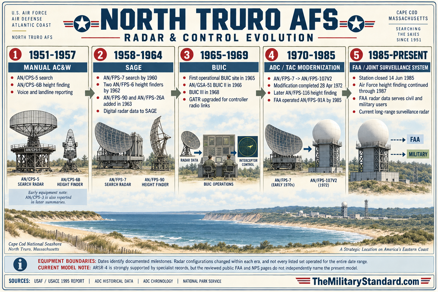
The station's initial radar sequence is not perfectly consistent across surviving summaries. The Air Force-sponsored 1995 report states that an AN/CPS-5 long-range search radar became operational in May 1951 and was followed by an AN/CPS-6B height-finder. Its scanned typeface can make the final letter appear as the numeral 8. Other later compilations describe a pair of World War II-era AN/CPS-3 sets at the beginning of operations. The National Park Service summarizes the matter as two radars installed in spring 1951.
The AN/CPS-5 was a long-range search set with a reported range of about 165 miles under favorable conditions. Like other early radar, it was limited by line of sight, target altitude, propagation, clutter, and the curvature of the earth. The height-finder supplied the altitude dimension needed for effective interception. The 1995 report describes shortcomings in the early height equipment, including difficulty with low-flying aircraft and targets above approximately 45,000 feet. These limitations drove later modernization and the addition of gap fillers.
North Truro's early information moved over three dedicated land lines. The lines linked the station to the ground-controlled interception function at Otis Air Force Base and to Air Defense Command headquarters at Ent Air Force Base, Colorado. New England Telephone Company built, staffed, and maintained a separate switching building near the family-housing area, and the building was heavily guarded. The arrangement illustrates how commercial communications infrastructure and civilian technicians became essential parts of the military warning network.
Otis Lashup site L-5 provided interim coverage before North Truro. ADC historical data lists L-5 with AN/CPS-5 search and AN/TPS-10A height-finding equipment from July 1950 until October 1951 and identifies North Truro P-10 as its successor. The relationship was operational replacement, not relocation of the Otis base. Once P-10 assumed the permanent radar mission, Otis continued as an interceptor, airborne-warning, command, and logistics installation while North Truro performed the coastal ground-radar function from a separate reservation.
Command Assignments and Organizational Evolution
The 762d passed through a series of higher headquarters as the continental defense structure changed. Compiled lineage records place it under the 540th Aircraft Control and Warning Group from activation, the 32d Air Division in February 1952, the 4704th Defense Wing in February 1953, the 4622d Air Defense Wing in October 1956, and the Boston Air Defense Sector in January 1957. Later assignments included the 35th Air Division in April 1966 and the 21st Air Division in November 1969. These changes did not move the station; they changed the chain that received and acted upon its data.
The squadron became the 762d Radar Squadron (SAGE) on December 15, 1958. On March 1, 1970, the squadron was inactivated and replaced by the 762d Air Defense Group because North Truro's BUIC responsibility required a larger command organization. The group remained until January 17, 1974, when the 762d Radar Squadron was activated again as BUIC sites were reduced. Lineage compilations place the reactivated squadron under the 21st Air Division and, from September 1983, the 24th Air Division, with inactivation on July 1, 1984.
The final year contains a documentary tension. A 1985 federal hurricane plan still lists the 762 Radar Squadron at North Truro as a 24th NORAD Region control location, while lineage accounts give July 1984 as the squadron's inactivation. The station itself did not deactivate until June 14, 1985. The likely explanation is a lag in plan data or continuation under a successor or residual organization, but the examined records do not establish a definitive final-station unit title for every month. The dates are therefore presented separately instead of treating the squadron and installation as identical entities.
Texas Tower No. 2 Support
North Truro became operational parent and shore support base for Texas Tower No. 2, also called the Georges Shoal Tower Annex. The offshore platform stood about 110 miles east of Cape Cod and resembled a Gulf of Mexico oil rig, which inspired the Texas Tower nickname. Long-range radar on the tower pushed detection farther seaward and was intended to provide roughly thirty additional minutes of warning against bombers approaching from the Atlantic.
The relationship began in December 1955, with the offshore radar flight assigned to the 762d. North Truro staged replacement crews, spare parts, supplies, and equipment. Helicopters used a station helipad, the remains of which the National Park Service identifies at the southeast corner of the former base. Dedicated supply facilities supported this work. During the tower-support period, military and civilian population at North Truro exceeded 500, a substantial increase over the station's normal complement.
Life aboard TT-2 was isolated and physically demanding. Crews normally served rotations of about thirty days amid vibration, machinery noise, foghorns, weather, and the risks of helicopter or boat transfer. North Truro provided the shoreward human and logistical bridge that made the offshore watch possible. Otis Air Force Base and the 4604th Support Squadron also furnished broader Texas Tower logistics, so neither North Truro nor Otis alone should be described as the entire support system.
TT-2 operated only during the brief Texas Tower era. After the loss of TT-4 in January 1961 and as costs, risk, and changing technology undermined the concept, the Air Force ended offshore tower operations. Texas Tower No. 2 ceased its mission in January 1963. North Truro's own radar and control mission continued for more than two decades, while the helipad and historical record remained evidence of the station's unusual offshore responsibility.
Remote Gap-FILLER Network
Long-range search radar could not reliably see aircraft hidden below the radar horizon or masked by local terrain. North Truro therefore served as parent for unmanned AN/FPS-14 gap fillers that watched selected low-altitude approaches and forwarded their data through AN/FST-1 equipment. These were separate small installations, not antennas within the main station. They had their own land, buildings, towers, site codes, utilities, and maintenance requirements.
Westboro Gap Filler Annex, historically spelled Westboro and located near modern Westborough, carried P-10A and later Z-10A. Air Force installation directories list Westboro as installation number 4449. ADC data places manual operation in June 1957, SAGE operation by September 1958, and closure about June 1962. Specialist site surveys place the annex on Fay Mountain at approximately 42.239825 north and -71.628133 west and report that the operations building is gone while the radar tower survives. Those present-condition details require confirmation during the annex's dedicated history.
Fort Dearborn Gap Filler Annex carried P-10B and later Z-10B. It reused the former Portsmouth or Rye Air Force Station locality in New Hampshire. ADC data assigns the gap-filler function to the 762d and gives SAGE operation in September 1958 and closure in June 1968.
Chilmark Gap Filler Annex on Martha's Vineyard had a more complicated parentage and code sequence. Official 1956 and 1957 Air Force directories list Chilmark as P-45B, installation number 4386, an active detached auxiliary of Montauk P-45 located about one mile south of Chilmark. Later ADC data places it under North Truro as P-10E and then Z-10E, although one table variant appears as Z-10F. It entered SAGE service in 1958 and closed in June 1968. The change reflects reassignment within the radar network, not movement of the annex.
SAGE Conversion
Manual plotting and voice reporting could not efficiently manage the growing volume and speed of air traffic. The Semi Automatic Ground Environment combined radar inputs, digital communications, large computers, identification processes, and command displays into a regional network. North Truro joined SAGE in 1958 and began sending radar data to a direction center. The 1995 report identifies the Boston Air Defense Sector direction center at Hancock Field near Syracuse, New York; some later summaries identify other SAGE center relationships by period. The exact receiving center could change as sectors and divisions reorganized.
SAGE did not make the local station automatic in the ordinary sense. North Truro still needed radar operators, maintenance technicians, communications specialists, identification personnel, security, power generation, and administrative support. Local equipment converted radar plots into digital messages and carried them over data circuits to the direction center. There computers combined multiple stations into a regional air picture, while weapons controllers directed interceptors and coordinated with other defense agencies.
By 1962, the official architectural report lists a General Electric AN/FPS-7 search radar and two AN/FPS-6 height finders. The AN/FPS-7 supplied improved search coverage, while the height finders measured target altitude. Specialist equipment chronologies add intermediate AN/FPS-8 and AN/GPS-3 service and later identify the AN/FPS-7 modification as AN/FPS-107. Because available summaries do not give installation and removal dates for every set, the history distinguishes well-documented milestone equipment from probable intermediate configurations.
Backup Interceptor Control
SAGE concentrated command and data processing in large direction centers. Air-defense planners recognized that those centers could be disabled early in a nuclear attack, leaving functioning radar stations without centralized control. Backup Interceptor Control placed computers and control consoles at selected radar stations so they could combine regional inputs and direct fighters if the SAGE center failed. North Truro's coastal position, communications, and radar coverage made it an important test and operational location for this redundancy.
North Truro received computers and data links in 1962, and its 1963 mission added manual backup control of interceptor aircraft. An official Air Force chronology states that the first of thirteen computer-controlled BUIC radar sites became operational at North Truro in 1965. The 1995 station report dates installation of the Burroughs AN/GSA-51 and the first BUIC II configuration to 1966. These statements can be reconciled as phased initial operation, equipment installation, testing, and formal configuration rather than a single instant.
Construction for the first BUIC III site began at North Truro on July 15, 1966, according to the official Air Force fiscal-year chronology. After communications modifications at the nearby GATR facility, North Truro became the first BUIC III station in 1968. BUIC III used a more capable Burroughs D800-series computer system and multiple control consoles, allowing local personnel to accept data from other radars, form a broader tactical picture, and control interceptors when regional SAGE facilities were unavailable.
BUIC responsibility explains the 1970 elevation from radar squadron to 762d Air Defense Group. At higher readiness levels, the North Truro commander could assume broader air-defense authority, while controllers used the local computer and communications system as a regional backup. The group designation ended in 1974 as the threat, force structure, and number of BUIC sites declined. Even after the group reverted to a squadron, the station continued surveillance and control support through the remaining Cold War years.
Radar Modernization and Late Configuration
The 1963 modernization introduced an AN/FPS-90 height finder and an AN/FPS-26A long-range height finder. The 1995 report also mentions an AN/FPS-14 medium-range search set configured for SAGE at the main station, an unusual assignment because AN/FPS-14 was normally a gap-filler radar. Without the underlying 1963 unit-history exhibit, that statement should be treated cautiously. It may represent a temporary installation, a reporting shorthand for an annex, or a source transcription issue.
Later specialist chronologies identify AN/FPS-107 search, AN/FPS-90 and AN/FPS-26A height finding, and subsequent AN/FPS-91A and AN/FPS-116 equipment. By 1985, the FAA operated the AN/FPS-91A search radar within the emerging Joint Surveillance System. The Air Force retained height-finder operation until 1987, and the AN/FPS-116 is reported removed around 1988. Precise acceptance and disposal dates remain incomplete, but the broad sequence shows continuous modernization from vacuum-tube manual-network sets to joint digital surveillance.
Radar nomenclature must not be treated as a list of simultaneous equipment. Some designations reflect modification of an existing set, some replaced earlier systems, and some appear only in later compilations. Radomes, towers, operations rooms, generators, cooling, communications, and maintenance facilities changed with each generation. By the time of the 1995 documentation, original radar and GATR structures had been partly or completely removed and no original radar-program equipment remained on the NPS property.
Ground-Air Communications
Interception required reliable radio contact with fighter aircraft beyond the range or interference environment of the main operations area. The detached GATR site separated transmitters and receivers from radar and other electronic equipment while connecting them to controllers at North Truro. Its 5.3-acre tract, Building 2, antenna field, power, and circuits formed a distinct communications installation under the station's operational control.
The GATR site's 1968 modification was not routine maintenance. It provided the communications capability needed for North Truro to become the first BUIC III station, where local controllers might assume responsibility for a larger region during a SAGE outage. The annex therefore belonged to the command-and-control architecture as much as to the station radio system. Its physical separation also reduced interference and gave antennas a clear coastal setting.
In the early 1990s the FAA demolished the former GATR installation and constructed what the 1995 report called a VHF Omnidirectional Range with Tactical Air Navigation facility, or VORTAC. That report describes two small buildings beneath a circular roof crowned by a sixteen-foot conical tower and calls the facility unmanned. Current FAA location data instead classifies LFV as the Marconi VOR/DME, indicating that the navigation configuration or terminology changed. The report also says the GATR function had moved within the FAA radome at the main radar parcel.
Facilities and Self-Sufficiency
By the mid-1950s North Truro had become a substantial self-contained station. The Air Force-sponsored report describes approximately $4.657 million in station improvements and another $563,000 in family housing. The complex had its own generating plant, four wells, sewage treatment, roads, maintenance shops, warehouses, administration, food service, exchange, recreation, and living quarters. The generating capacity is printed as 1,800 kV in the report, but the intended unit may have been kVA; this history does not silently change the source.
The same report calls the installation a ninety-building complex, then itemizes fifty-five buildings in the main station and twenty-seven in family housing, a total of eighty-two. This internal inconsistency may reflect structures omitted from one count, temporary buildings, or differing inventory dates. Later NPS planning material describes fifty-seven buildings and approximately 115,000 square feet on the transferred property. The totals should not be combined because they represent different dates, ownership areas, and counting rules.
Four two-story buildings numbered 9 through 12, constructed in 1951, served administration and dormitory purposes and contained about 5,780 square feet each. Building 18 was the 4,680-square-foot dining hall. Building 22 served as a small theater and recreation building, and Building 23 was a two-story, sixty-six-room bachelor officers' quarters of about 11,240 square feet. Together these buildings framed daily life around the main quadrangle and supported continuous shift work.
Building 31, the 6,564-square-foot power plant completed in 1957, retained old turbines after closure. Building 32 served maintenance office and storage functions, Building 33 was a multipurpose recreation facility, and Building 36 was a maintenance shop. Building 15, a two-lane bowling alley completed in 1961, and Building 16, a recreation and multipurpose space, show that an isolated radar station required organized off-duty facilities as well as technical plant.
Family housing developed mainly during 1956-1959. The later NPS inventory describes twelve houses of about 1,648 square feet and six of about 1,815 square feet, all with garages and generally seven rooms. Housing separated from the operations core gave officers and families a residential neighborhood, while many enlisted personnel lived in dormitories. Up to thirty Air Force families also rented homes in Truro, linking the station directly to the civilian housing market.
Project Better Living renovated barracks, dining facilities, and the bachelor officers' quarters in 1967. Such work mattered operationally because remote duty, rotating shifts, and harsh weather affected retention and morale. Recreation included fishing, swimming, volleyball, football, table tennis, weightlifting, softball, movies, a recreation center, bowling, a library, and hobby activities. The station's social infrastructure helped turn a technically demanding watch site into a functioning community.
Community Relations
North Truro was one of the largest employers and organized communities in the town during much of the Cold War. The station employed as many as fifty local civilians, while military families used local schools, churches, stores, housing, and services. Air Force personnel joined the rescue squad and volunteer fire department, cooperated with the local Civil Defense office, supported charities, and entered a team in the local softball league. Games on the station's lighted field brought military and civilian residents together.
The TT-2 period intensified this relationship because the station population rose above 500 and the logistics flow increased. Supplies, contractors, aircrews, communications technicians, and support personnel moved through a small outer-Cape community. At the 1985 closure ceremony, a Truro selectman described station personnel as more than friends and neighbors and part of the community. The statement captures an institutional relationship built over thirty-four years, while not erasing the disruption caused by closure and abandoned facilities.
Tactical Air Command and the Joint Surveillance System
When Aerospace Defense Command was inactivated in 1979, North Truro passed to Tactical Air Command through Air Defense, Tactical Air Command. The change reflected consolidation rather than abandonment of continental warning. Crews continued operating radar, communications, and control functions, but the broader system was moving toward shared FAA and military surveillance, regional operations centers, and fewer staffed military stations.
The Joint Surveillance System allowed FAA long-range radars and military air-defense organizations to share data. At North Truro, the FAA assumed operation of the long-range search radar under an arrangement made before station closure. The National Park Service states that the radar remains an FAA and Air Force JSS asset and supplies primary tracking for international traffic approaching Boston Logan and New York Kennedy airports, while military users continue to identify and track aircraft approaching from the sea.
The current radar is widely identified in specialist inventories as an ARSR-4 three-dimensional long-range surveillance radar, but the reviewed public FAA and NPS pages do not name the current model. The history therefore treats ARSR-4 as strongly supported secondary identification, not as an independently confirmed current equipment statement. FAA documentation does verify an active environmental-technical function at Radar Site Building 48 and a North Truro long-range radar systems support unit.
Station Closure and Transition
The Air Force deactivated North Truro Air Force Station on June 14, 1985. The closure ceremony included speeches, an aircraft flyover, and lowering of the flag. Deactivation ended the staffed installation as an independent Air Force station, but not every mission or federal interest. A small Air Force contingent continued operating height-finding equipment in Building 48 until 1987, and the FAA already operated the long-range search radar for the JSS.
The radar transition was therefore phased. Search surveillance continued without interruption under FAA operation, military users retained access to the data, height finding remained an Air Force function for roughly two more years, and reported removal of the AN/FPS-116 occurred around 1988. The FAA received a separate northeastern parcel for the radar site. The former GATR tract also passed into FAA navigation and communications use after demolition and VORTAC construction in the early 1990s.
Approximately 110 acres of the remaining former station passed to the National Park Service in 1994. By that time, radar towers and original GATR structures had been removed or substantially altered, and the Air Force had undertaken environmental work. The transfer placed a large Cold War support campus within Cape Cod National Seashore but left the active radar parcel outside the NPS reuse area. The divided ownership and use remain central to understanding present North Truro.
Historic Preservation and Architectural Recordation
Impending disposal required the Air Force to evaluate historic resources under federal preservation law. The 1995 Historical and Architectural Documentation Reports project drew on real-property records, engineering drawings, 762d unit histories, newspapers, interviews, and Air Force historical studies. It produced HABS-level documentation for selected buildings and photographic or database records for others. The study found the station historically important to Cold War air defense but concluded that loss of original radar equipment and technical structures had greatly compromised site integrity.
The surviving support buildings nevertheless preserve the physical pattern of station life. The quadrangle, dormitories, dining hall, recreation buildings, BOQ, power plant, shops, family houses, roads, and utility features show how a permanent radar station functioned as both technical installation and community. National Park Service planning has reused some structures and removed others. A 2017 Historic American Buildings Survey report supplied additional documentation before demolition, providing a durable visual and architectural record even where buildings no longer survive.
Preservation at North Truro involves choices rather than freezing the property in 1985. The active FAA radar cannot be interpreted as untouched Air Force equipment, and NPS program buildings have new functions. Demolition addressed safety, hazardous materials, and maintenance burdens, while adaptive reuse retained selected buildings.
Environmental History
The Air Force conducted environmental remediation into the early 1990s, documented in a 1994 environmental baseline survey prepared for transfer. National Park Service planning material identifies known work on friable asbestos, underground storage tanks, and PCB-containing transformers and says no known fuel or pesticide contamination was disclosed in that baseline. This language describes what the survey reported at the time; it is not proof that every release pathway or hazardous material was absent.
Additional concerns appeared after transfer. Hazardous material was found in old sewer pipes, and the Air Force remediated the sewer system in 1997. NPS investigations in 2000 and 2001 found lead-containing and asbestos-containing building materials in some structures, while other sampled materials were free of those hazards. Rehabilitation can therefore require material-specific abatement. NPS has stated that program partners will not be made responsible for sitewide Department of Defense remediation, although they may be responsible when their work disturbs hazardous building material.
The federal hazardous-waste compliance docket lists the Truro installation sewage-treatment plant under identifier MA0572124493, with an address off Aldrich Road and Air Force responsibility. Docket listing is an information and compliance mechanism, not by itself a finding that the entire former station is a Superfund National Priorities List site. The reviewed evidence does not establish NPL listing for North Truro. Claims about cleanup status must remain tied to specific facilities, media, dates, and responsible agencies.
Coastal erosion, wind, salt exposure, vegetation, aging utilities, and long vacancy also affect the former station. These are preservation and safety issues even when they are not hazardous-waste releases. NPS work has included water, electrical, fire-suppression, wastewater, demolition, and stabilization projects. The condition of any individual building can change, and historical photos or prior planning descriptions should not be treated as current access or structural-safety determinations.
The Highlands Center
The National Park Service incorporated its approximately 110 acres into Cape Cod National Seashore and developed the Highlands Center concept as a place for arts, science, education, and interpretation. The 1998 General Management Plan introduced the concept, and later planning examined reuse of housing, offices, maintenance shops, recreation buildings, and laboratories. NPS reports adaptive reuse of six buildings, infrastructure improvements, and more than $1.2 million spent on demolition.
The North Atlantic Coastal Laboratory occupies former commissary Building 45. Buildings 14 and 17 support the Atlantic Research and Learning Center classroom and laboratory, while former maintenance and telephone buildings serve park operations. Building 35 was adapted for a wood-fired kiln in 2008, and Payomet Performing Arts Center has used the former NCO club area and summer-event facilities. These uses preserve selected structures through continued activity rather than museum restoration.
Utility rehabilitation has constrained reuse. NPS completed initial water, fire-suppression, electrical, and wastewater improvements around the quadrangle in 2007 and repaired much of the overhead electrical system in 2010. A Title 5 wastewater system provides about 5,000 gallons per day for early redevelopment. Full occupancy would require further utility investment or lower-impact technologies. The former station's self-contained infrastructure was not automatically suitable for modern public, laboratory, performance, or residential use.
In 2016, NPS completed a solar-roof project on Buildings 14 and 45. Ninety-one photovoltaic panels provide a total rated capacity of 28.665 kilowatts, with forty panels on the classroom and fifty-one on the coastal laboratory. NPS estimated that annual production would offset about 63 percent of the projected electrical use of both buildings. The project illustrates how the Cold War campus has been adapted for conservation and research goals.
The Highlands Center mission remains active in planning and partner work, but general access is restricted. The NPS page updated in October 2024 says the site is closed to the public for general access except attendance at Payomet summer special events. That restriction supersedes older promotional descriptions that may imply routine visitation.
Current Status
North Truro is a divided federal site. The staffed Air Force station is closed. Approximately 110 acres are managed by Cape Cod National Seashore as the Highlands Center, with selected buildings adapted for park, science, arts, education, and partner use and other structures removed, vacant, or awaiting disposition. General public access is closed except for specifically announced Payomet summer events. Current conditions must be checked with NPS before any visit.
The FAA operates the separate long-range radar parcel as part of the FAA and Air Force Joint Surveillance System. Radar information supports civil air traffic control and military identification and warning. The former GATR tract is occupied by the active, unmanned LFV Marconi VOR/DME navigation facility. Neither active FAA facility should be entered or approached on the assumption that the historic Air Force station is abandoned public land.
Substantial Cold War fabric survives in the support campus, but the original radar technical landscape does not. The 1995 Air Force study found radar and GATR structures partly or completely demolished and original radar equipment removed. Later demolition reduced the building inventory further. Surviving quadrangle buildings, family housing, utilities, recreation facilities, road patterns, the former helipad area, and documented archaeological traces collectively convey the station's history better than any single remaining structure.
Chronology
- World War II Army coast-artillery personnel use the North Truro bluff for antiaircraft training and construct gun positions, a small cantonment, and a magazine.
- 1947-11-12 Secretary of Defense James Forrestal publicly announces planning for a national radar early-warning network.
- 1948 The Air Force acquires the North Truro property for a permanent radar station.
- Early 1949 Construction probably begins under Army Corps of Engineers supervision.
- 1949-09-22 President Harry S. Truman announces that the Soviet Union has detonated an atomic device, increasing urgency for continental air defense.
- 1949-12-02 The Air Force directs the Corps of Engineers to proceed with the first twenty-four priority permanent-network radar stations, including North Truro.
- 1950-07 Temporary Otis Lashup radar site L-5 begins operation with AN/CPS-5 and AN/TPS-10A equipment.
- 1950-11-14 The 762d Aircraft Control and Warning Squadron is constituted.
- 1950-11-27 The 762d Aircraft Control and Warning Squadron is activated.
- Late 1950-12 The first fifty airmen arrive at North Truro to guard the site during equipment installation.
- 1951-04 The 762d administrative section transfers from Otis AFB to North Truro.
- 1951 spring NPS reports that two radars are installed at the station.
- 1951-05 The Air Force-sponsored station history reports the AN/CPS-5 search radar operational.
- 1951-06 Eighteen officers and 173 airmen are living at the station.
- 1951-06 North Truro joins the air-defense network on a minimum four-hour-per-day operating schedule.
- 1951 A height-finding radar identified in the project report as AN/CPS-6B follows the search radar; later equipment compilations report an early pair of AN/CPS-3 sets.
- 1951-10 Otis Lashup radar L-5 is inactivated as North Truro P-10 assumes permanent coverage.
- 1951-12 The 1995 project summary uses December 1951 as the station-establishment milestone.
- 1952-02-06 Compiled lineage records assign the 762d to the 32d Air Division.
- 1953-02-16 The squadron is assigned to the 4704th Defense Wing.
- Mid-1950s The main station reaches approximately 125.67 acres, excluding 8.53 acres of easements, with a separate 5.3-acre GATR tract.
- 1955 Specialist equipment chronologies place AN/FPS-8 search equipment at North Truro, later modified as AN/GPS-3.
- 1955-12 North Truro becomes operational parent and shore support station for Texas Tower No. 2 on Georges Shoal.
- 1956-1959 Family housing is developed south of the main operations area.
- 1956-10-18 The 762d is assigned to the 4622d Air Defense Wing.
- 1957-01-08 The 762d is assigned to the Boston Air Defense Sector.
- 1957-06 Westboro P-10A enters documented manual gap-filler operation under North Truro.
- 1957 Fort Dearborn P-10B and Chilmark, transitioning from P-45B to P-10E, join the North Truro gap-filler network.
- 1957 The main-station electrical power building, Building 31, is completed.
- 1958 North Truro begins feeding radar data into the SAGE system.
- 1958-06 ADC data places the Chilmark annex in SAGE operation.
- 1958-09 ADC data places Westboro and Fort Dearborn gap fillers in SAGE operation.
- 1958-12-15 The unit is redesignated the 762d Radar Squadron (SAGE).
- 1958-1959 AN/FPS-6-series height-finder equipment enters the station's documented configuration.
- 1960 Specialist accounts place AN/FPS-7 search radar in operation and report retirement of the AN/GPS-3.
- 1961 A two-lane bowling alley, Building 15, is completed.
- 1962 The station operates an AN/FPS-7 search radar and two AN/FPS-6 height finders according to the Air Force-sponsored report.
- 1962 Computers and data links are installed for backup interceptor-control work.
- About 1962-06 Westboro P-10A/Z-10A closes.
- 1963 The station mission statement adds manual backup intercept control of fighter aircraft.
- 1963 AN/FPS-90 and AN/FPS-26A height-finder equipment enters the documented configuration.
- 1963 The station report also lists an AN/FPS-14 at the main site, an unusual assignment that remains qualified.
- 1963-01 Texas Tower No. 2 ends operational service, concluding North Truro's offshore parent role.
- 1965 An official Air Force chronology identifies North Truro as the first operational computer-controlled BUIC radar site.
- 1966 Installation of the Burroughs AN/GSA-51 supports the first BUIC II configuration at North Truro.
- 1966-04-01 The 762d is assigned to the 35th Air Division.
- 1966-07-15 Construction begins for the first BUIC III site at North Truro.
- 1967 Project Better Living renovations improve barracks, dining, and BOQ facilities.
- 1968 Modification of the detached GATR site enables North Truro to become the first BUIC III radar station.
- 1968-06 Fort Dearborn and Chilmark gap fillers close.
- 1969-11-19 The 762d is assigned to the 21st Air Division.
- 1970-03-01 The 762d Radar Squadron is inactivated and replaced by the 762d Air Defense Group for the BUIC mission.
- 1974-01-17 The 762d Air Defense Group is inactivated and the 762d Radar Squadron is reactivated.
- 1979 North Truro transfers to Tactical Air Command through Air Defense, Tactical Air Command after Aerospace Defense Command is inactivated.
- 1983-09-23 Compiled lineage records assign the 762d Radar Squadron to the 24th Air Division.
- 1984-06-18 A declaration of excess real property documents the coming disposal of North Truro AFS.
- 1984-07-01 Compiled lineage records give this date for inactivation of the 762d Radar Squadron.
- 1985 A federal hurricane operations plan still lists the 762 Radar Squadron at North Truro, creating a final-unit date discrepancy.
- By 1985 The FAA operates the AN/FPS-91A search radar as the station transitions into the Joint Surveillance System.
- 1985-06-14 The Air Force deactivates North Truro Air Force Station after a closure ceremony and flag lowering.
- 1985-1987 A small Air Force contingent continues operating height-finding equipment in Building 48.
- About 1988 Specialist equipment histories report removal of the AN/FPS-116.
- Early 1990s The FAA demolishes the detached GATR site and constructs an unmanned VORTAC facility on the tract.
- Early 1990s The Air Force continues environmental remediation in preparation for property transfer.
- 1994 Approximately 110 acres are conveyed to the National Park Service for Cape Cod National Seashore.
- 1994 An environmental baseline survey documents transfer-related hazardous-material and remediation work.
- 1995-07 The Air Force-sponsored historical and architectural documentation report is completed.
- 1997 The Air Force remediates hazardous material found in portions of the old sewer system.
- 1998 The Cape Cod National Seashore General Management Plan presents the Highlands Center concept.
- 2000-2001 NPS building investigations identify lead-containing and asbestos-containing materials in some structures.
- 2007 Initial water, fire-suppression, electrical, and wastewater improvements reactivate important quadrangle systems.
- 2008 Building 35 is rehabilitated for Castle Hill's wood-fired kiln.
- 2009-07 A new flagpole is dedicated and former 762d members raise the flag at the Highlands Center.
- 2010 NPS repairs most of the overhead electrical system.
- 2016 NPS completes a 91-panel, 28.665-kilowatt solar project on Buildings 14 and 45.
- 2017 Final HABS documentation records buildings planned for demolition.
- 2024-10-28 The current NPS Highlands Center page states that general access remains closed except for Payomet summer special events.
Information sources (34)
- PDFU.S. Army Corps of Engineers and U.S. Army Construction Engineering Research Laboratories, Historical and Architectural Documentation Reports of North Truro Air Force Station, July 1995
Principal installation history, property, construction, radar, BUIC, GATR, facilities, community, closure, and preservation source.
- WEBNational Park Service, Exploring the Highlands Center
Official concise history of the 762d, early radar and land lines, Texas Tower support, closure, JSS continuation, flag ceremony, and solar project.
- WEBNational Park Service, Highlands Center at Cape Cod National Seashore
Current official access statement, 110-acre conveyance, reuse mission, partner program, demolition, and adaptive-reuse information.
- WEBNational Park Service, Description of Site and Buildings
Building inventory, floor areas, utilities, housing, hazardous materials, remediation, and reuse planning.
- WEBNational Park Service, Final Historic American Buildings Survey Report 2017
Preservation record and downloadable HABS documentation for former station buildings before demolition.
- WEBNational Park Service, Past Construction Projects
Official record of Cape Cod National Seashore construction, demolition, and stabilization projects affecting the former station.
- PDFAerospace Defense Command History Office, Historical Data of the Aerospace Defense Command, 1946-1973 (17.67 MB)
Local authoritative transcription used for site codes, 762d parentage, gap-filler dates, and radar-network relationships.
- PDFAerospace Defense Command, A History of Texas Towers in Air Defense, 1952-1964
Command-level history of offshore radar policy, construction, operations, logistics, hazards, and termination.
- WEBU.S. Northern Command, ADC and Antibomber Defense, 1946-1972
Declassified Air Defense Command study used for the wider evolution of manual radar, SAGE, BUIC, and continental defense.
- PDF1U.S. Northern Command, CONAD-NORAD Historical Summary, July through December 1957
Official site table confirming North Truro, the 762d, and permanent-network defense assignment.
- PDFU.S. Northern Command, 1956-1957 NORAD-CONAD History
Official contemporary table of operational land-based permanent radars including North Truro site 10 and squadron 762.
- PDFOffice of Air Force History, Searching the Skies: The Legacy of the United States Cold War Defense Radar Program
Official thematic history of radar-network development, station types, SAGE, facilities, and preservation context.
- PDFAir Force History and Museums Program, American Aerospace Events: Firsts, Lasts, and Significant Accomplishments
Official chronology identifying North Truro as the first operational computer-controlled BUIC radar site in 1965.
- PDFDepartment of the Air Force, Chronology of United States Air Force Major Events, Fiscal Year 1967
Official chronology recording the July 15, 1966 start of construction for the first BUIC III site at North Truro.
- PDFKenneth Schaffel, The Emerging Shield: The Air Force and the Evolution of Continental Air Defense, 1945-1960
Official Air Force history of the policy, technology, and organizational setting in which North Truro was built.
- PDFDepartment of the Air Force, USAF Installations Directory, July 1, 1956
Period official directory confirming active detached auxiliary listings, including Westboro and Chilmark-era administrative data.
- PDFDepartment of the Air Force, USAF Installations Directory, March 31, 1957
Period official directory confirming Westboro installation 4449 and Chilmark P-45B installation 4386.
- PDFDepartment of the Air Force, Directory of USAF Organizations, July 31, 1964
Period official directory confirming the 762d Radar Squadron at North Truro.
- PDFFederal Aviation Administration, Notice JO 1720.86
Official FAA facility directory entries for the North Truro radar site, Building 48 environmental function, and long-range radar systems support unit.
- PDFNational Oceanic and Atmospheric Administration, National Hurricane Operations Plan FCM-P12-1985
Contemporary federal plan listing the North Truro radar control location in the 24th NORAD Region.
- WEBU.S. Environmental Protection Agency, Federal Agency Hazardous Waste Compliance Docket
Federal listing for the Truro installation sewage-treatment plant and its Air Force responsibility.
- WEBU.S. Environmental Protection Agency, Federal Agency Hazardous Waste Compliance Docket Update No. 5
Period docket information for the Air Force Truro installation sewage-treatment plant.
- WEBMassachusetts Department of Environmental Protection, Provincetown Water Department Source Water Assessment
State source-protection inventory noting tank records near the North Truro FAA search radar.
- WEBFortWiki, North Truro Air Force Station
Specialist synthesis used to compare radar equipment sequences, current ARSR-4 identification, site codes, call signs, and annex coordinates.
- WEB25. FortWiki, North Truro FAA Radar Site
Specialist site record for the continuing JSS installation and reported ARSR-4 equipment.
- WEBRadomes, North Truro AFS, Massachusetts
Specialist veteran-maintained station record used for coordinate, call-sign, equipment, and photographic cross-checks.
- PDFUSAF Unit History, 762 Radar Squadron (SAGE)
Secondary compilation of lineage, assignments, station mission, gap fillers, and equipment, checked against official directories and histories where available.
- PDFBitsavers, ADC BPH 55-51 BUIC II Positional Handbook, July 1965
Contemporary technical handbook supporting North Truro's position in the BUIC II command and control network.
- WEBRadomes, Chilmark early history
Specialist documentation of the P-45B to P-10E code and parentage transition at the Martha's Vineyard gap-filler site.
- PDFNational Park Service, Cape Cod National Seashore Foundation Document
Official park purpose and resource-management context for the transferred former station property.
- PDFMassachusetts Executive Office of Environmental Affairs, Cape Cod Watershed Assessment and Action Plan
State planning context for the former North Truro property and Highlands Center reuse.
- WEBNational Park Service, Cape Cod National Seashore General Management Plan
Official planning framework that introduced the Highlands Center reuse concept for the former station.
- WEBNational Park Service, Highlands Center map
Official map depicting the NPS reuse area, major former station buildings, roads, and program spaces.
- PDFFederal Aviation Administration, Order JO 7350.9M Location Identifiers
Official identifier source confirming LFV as the North Truro Marconi VOR/DME; current coordinate and operating details were cross-checked against the FAA-derived 2026 facility record.