
Texas Tower No. 3 / Nantucket Shoal Radar Station, Massachusetts
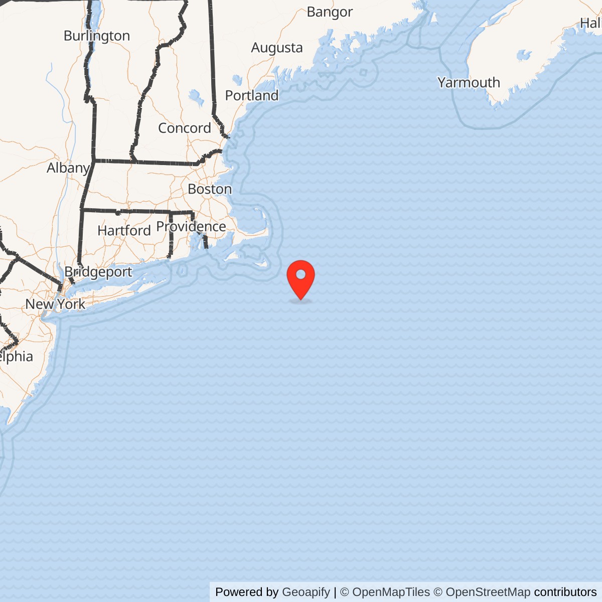
Longitude: -69.316667
Site Number: TT-3
Official Base Website: Former Texas Tower No. 3 offshore site, platform removed
Current Role: Open Atlantic water at the former TT-3 operating location on Nantucket Shoals. The complete platform was separated from its legs on 1964-08-06, floated, and towed away for salvage. No staffed station, radome, radar, helipad, or complete platform remains. Exact status of cut legs, foundations, cables, or scattered seabed material is unresolved without modern site-specific hydrographic or archaeological survey.
Texas Tower No. 3 was a fixed offshore United States Air Force radar station on Nantucket Shoal in the western North Atlantic. Air Defense Command built it to move long-range search and height-finding coverage beyond the New England coast, add warning time against bomber approaches, and provide a seaward radar input to the continental air-defense system. The platform was launched in South Portland, Maine, towed to the shoal in August 1956, accepted for beneficial occupancy on November 29, 1956, and developed into an operational manual and SAGE-connected station.
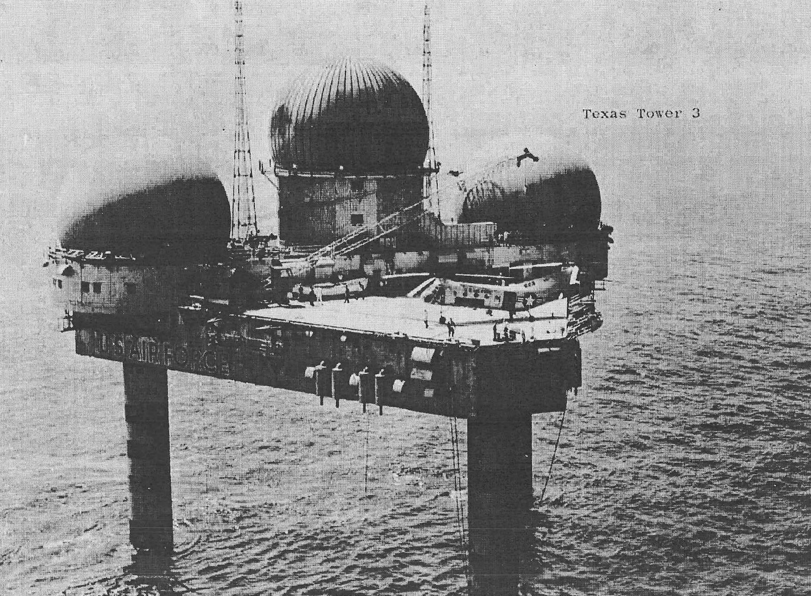
The tower was both a radar installation and an artificial island. A triangular steel platform carried radar and communications equipment, power generation, water production, repair shops, storage, living quarters, medical space, a galley, recreation rooms, and a helicopter deck. Three caisson legs fixed the station to the seabed. Every military function therefore depended on marine engineering, weather forecasting, aviation and vessel support, corrosion control, redundant machinery, and the judgment of a crew living far from immediate shore assistance.
The operational record is more complicated than the common statement that TT-3 served from 1958 to 1963. Beneficial occupancy occurred in 1956, but Air Defense Command's consolidated equipment table places manual operations and the documented radar activation sequence in October 1958, followed by SAGE operations in April 1960. The search radar evolved from AN/FPS-20 to AN/FPS-20A and AN/FPS-67 configurations, while two AN/FPS-6 height finders remained central to altitude determination. The 773d Radar Squadron at Montauk Air Force Station supplied the operational relationship, and the 4604th Support Squadron at Otis Air Force Base sustained the offshore installation.
Severe storms and seabed scour ultimately made reliable operation costly and dangerous. During the Cuban Missile Crisis in November 1962, high waves forced the tower off the air and reduced it to seven people. Fifty-three men returned when conditions improved, but inspectors found severe scouring and erosion around the legs, causing another evacuation on November 20. The Joint Chiefs of Staff then retained only a caretaker capability while Airborne Long Range Input aircraft approached operational readiness. TT-3 was decommissioned and its equipment turned off on March 25, 1963.
Unlike Texas Towers No. 2 and No. 4, TT-3 did not remain as a complete wreck at its operating site. After equipment removal, demolition planners filled and sealed the lower structure with urethane foam. On August 6, 1964, explosive charges separated the platform from its legs; the platform submerged briefly, resurfaced as intended, and was towed away for salvage.
Installation Identity, Name, and Scope
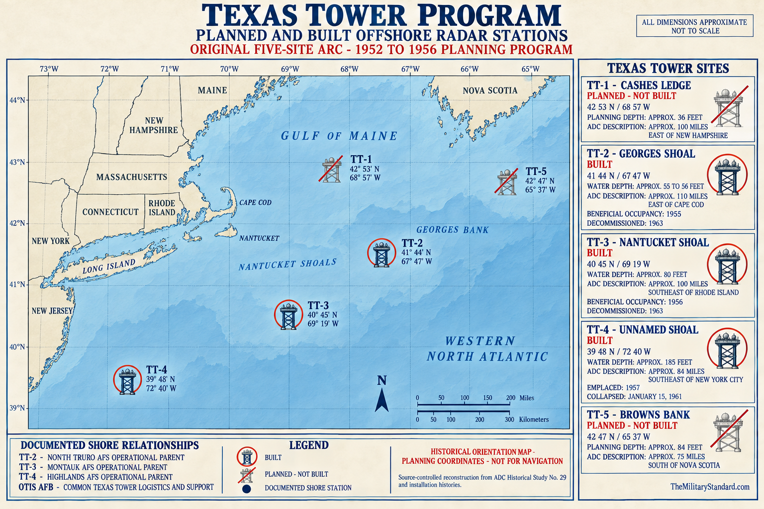
Texas Tower No. 3, Texas Tower 3, TT-3, Nantucket Shoal Radar Station, and Nantucket Shoals Air Force Station refer to the same offshore Air Defense Command installation. The formal site code was TT-3. The word tower described the oil-platform-like structure rather than a conventional radar tower on land, while the number identified its place in the original five-site seaward-extension program. Only TT-2, TT-3, and TT-4 were built; TT-1 at Cashes Ledge and TT-5 at Browns Bank remained canceled projects.
The installation must be distinguished from Montauk Air Force Station, Otis Air Force Base, Suffolk County Air Force Base, and the mainland organizations that supported it. Montauk and the 773d Radar Squadron provided the operational parent relationship commonly recorded for TT-3. Otis and the 4604th Support Squadron supplied the specialized logistics, maintenance, administration, and aircraft support system for the Texas Towers. These were connected installations and organizations, not alternate names for the offshore platform.
Nantucket Shoal and Nantucket Shoals also require careful usage. The broader Nantucket Shoals region contains many named shoals, channels, banks, currents, and navigation hazards south and east of Nantucket. Historical Air Force tables label the tower simply Nantucket Shoal. That military designation does not define the entire hydrographic region as station property, nor does it convert a wide marine area into a former Air Force parcel. The installation record is limited to the platform, its support systems, and the immediate construction and operating footprint.
The Massachusetts placement is a catalog convention based on the installation's association with Nantucket and its mainland command and support network. It is not a claim that the platform stood on Massachusetts land, within a county parcel, or inside ordinary municipal jurisdiction. TT-3 occupied federal offshore waters and a fixed seabed position far from shore, but the public records reviewed here do not establish a surveyed Air Force property boundary, lease polygon, or continuing military estate at the site.
This history treats November 29, 1956 as beneficial occupancy and March 25, 1963 as operational inactivation. It separately records October 1958 manual operation, April 1960 SAGE operation, and August 6, 1964 physical removal. This layered chronology prevents opening, operational readiness, network integration, decommissioning, equipment removal, demolition, towing, and final scrapping from collapsing into one misleading pair of dates.
Location, Offshore Jurisdiction, and Coordinates
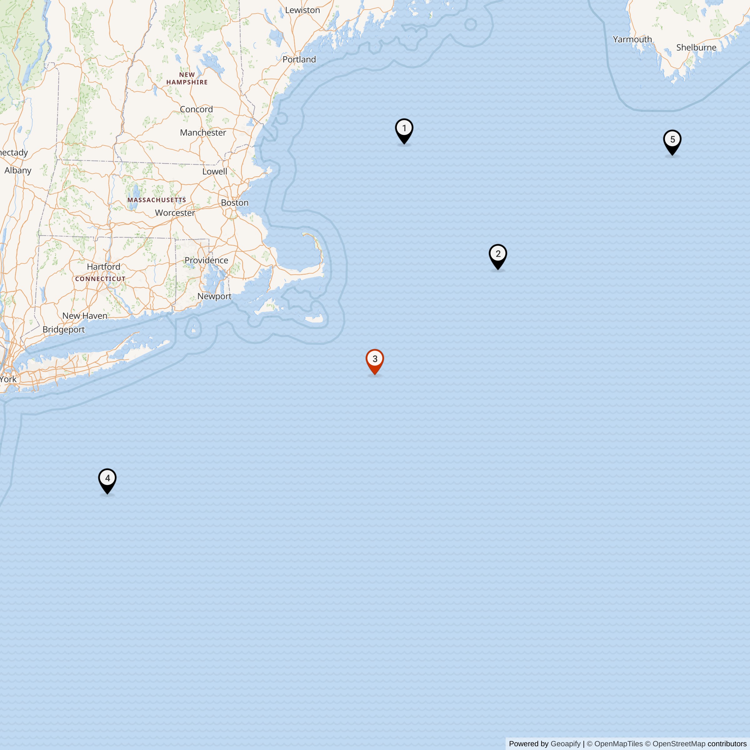
The later Air Force site listing gives TT-3 at 40 degrees 45 minutes north, 69 degrees 19 minutes west. Converted to decimal form, the representative point is 40.750000 north latitude, 69.316667 west longitude. It lies in the Atlantic southeast of Nantucket and is commonly described in secondary sources as roughly 50 miles from the island, in approximately 80 to 83 feet of water. Those distance and depth figures are useful orientation, but they are not substitutes for a construction survey or current hydrographic chart.
This coordinate is labeled a representative historical Air Force station point. It is not warranted as the center of the platform to modern survey accuracy, the center of a property boundary, a surviving leg position, a navigation waypoint, a dive target, or an obstruction fix. Rounded degrees and minutes can shift a point by hundreds or thousands of feet. Marine construction records, demolition plans, contemporary charts, and modern multibeam survey would be needed to reconstruct the exact platform and residual-foundation geometry.
National Marine Fisheries Service observations introduce an important coordinate conflict. A 1960 table for Nantucket Shoals, Texas Tower No. 3 prints 41 degrees 00 minutes 52 seconds north and 69 degrees 29 minutes 37 seconds west, materially northwest of the common Air Force point. That scientific coordinate may represent an observing location, a transcription or plotting convention, or a different reference associated with the data series. It is preserved as a documented observation-station coordinate, not silently substituted for the installation point.
The broader setting consisted of shallow, irregular shoal water exposed to Atlantic storms, fog, currents, and wave action. Shallow water made a fixed caisson platform feasible, but it also concentrated wave energy and allowed moving water to remove sediment around structural legs. The location thus offered the strategic benefit of an outward radar position and the engineering liability of an exposed seabed foundation. Those two facts remained linked throughout TT-3's service life.
No acreage is entered for the installation. Contemporary descriptions commonly treat the triangular platform as approximately one-half acre of usable surface, but that is a structural floor-area analogy rather than a landholding. The tower did not create a conventional deeded parcel extending across the shoal. Any legal description of seabed control, construction exclusion, safety area, or later federal disposition would require records not recovered in this research.
Strategic Requirement and Program Origins The Texas Tower program grew from the continental air-defense emergency of the early 1950s. Soviet long-range bombers, atomic weapons, and possible approaches across the North Atlantic compelled the United States to build overlapping warning belts. Shore stations improved coverage over land and along the coast, but radar line of sight left a low-altitude warning gap seaward. A bomber flying beneath a coastal radar horizon could approach important northeastern targets before a mainland station obtained a useful track.
MIT Lincoln Laboratory examined this seaward-extension problem while developing the Cape Cod experimental system and the concepts that became SAGE. On August 1, 1952, the laboratory outlined a fixed offshore platform modeled generally on Gulf of Mexico oil structures. Placing powerful radars on shallow Atlantic banks promised earlier detection without foreign land bases and a more persistent position than a ship or aircraft could provide. The nickname Texas Tower came from the oil-platform resemblance, not from geography or a Texas-based unit.
The Air Force and Navy divided responsibility according to institutional expertise. Air Defense Command defined the operational need and would operate the radar station. The Navy Bureau of Yards and Docks managed hydrographic investigation, design, specifications, and construction contracting because it possessed maritime engineering experience. Lincoln Laboratory contributed systems concepts and network development. This divided arrangement enabled an unprecedented project, but it also complicated responsibility for design, acceptance, structural inspection, maintenance, and operational risk.
Planners initially proposed five platforms. TT-1 at Cashes Ledge and TT-5 at Browns Bank were the planned endpoints, while TT-2 at Georges Shoal, TT-3 at Nantucket Shoal, and TT-4 off New Jersey occupied the central arc. The five-site program was authorized in autumn 1953. Navy plans and specifications followed in March 1954, site borings and surveys proceeded that summer, and an October 1954 feasibility report supported the concept. TT-2 was chosen as the prototype in December 1954.
TT-3 was not merely a copy placed at another coordinate. Experience with the prototype influenced later engineering, and the Nantucket location imposed its own depth, bottom, transport, and support conditions. By the time TT-3 moved toward construction, the program had already absorbed lessons about platform launch, offshore jacking, caisson installation, equipment vibration, aviation limits, and long-distance communications. The later tower therefore belonged to a continuing design process rather than a frozen 1952 sketch.
The strategic goal was warning geometry, not independent destruction of an attacking force. TT-3 would detect and measure aircraft, help identify and classify tracks, support local weapons-control work where authorized, and pass information toward direction centers and fighter-interceptor units. Its value came from adding time and a seaward viewing angle to a network. It could not by itself eliminate low-level penetration, weather interference, communications failure, or the need for airborne and shipborne surveillance.
Design and Physical Layout
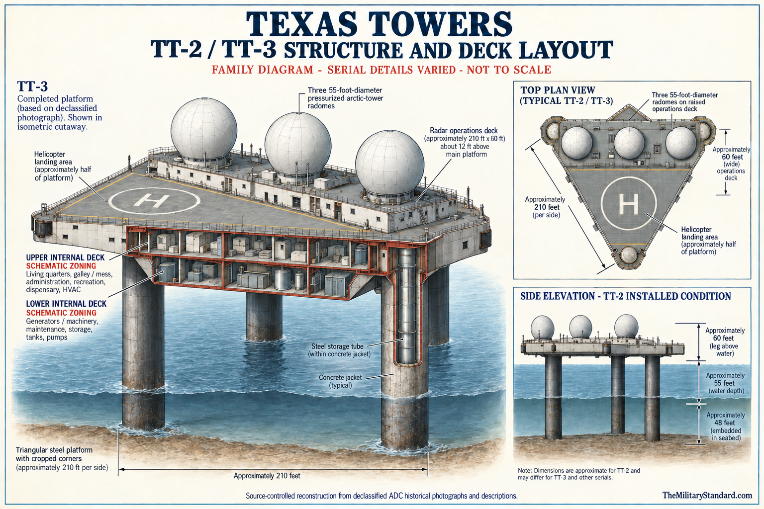
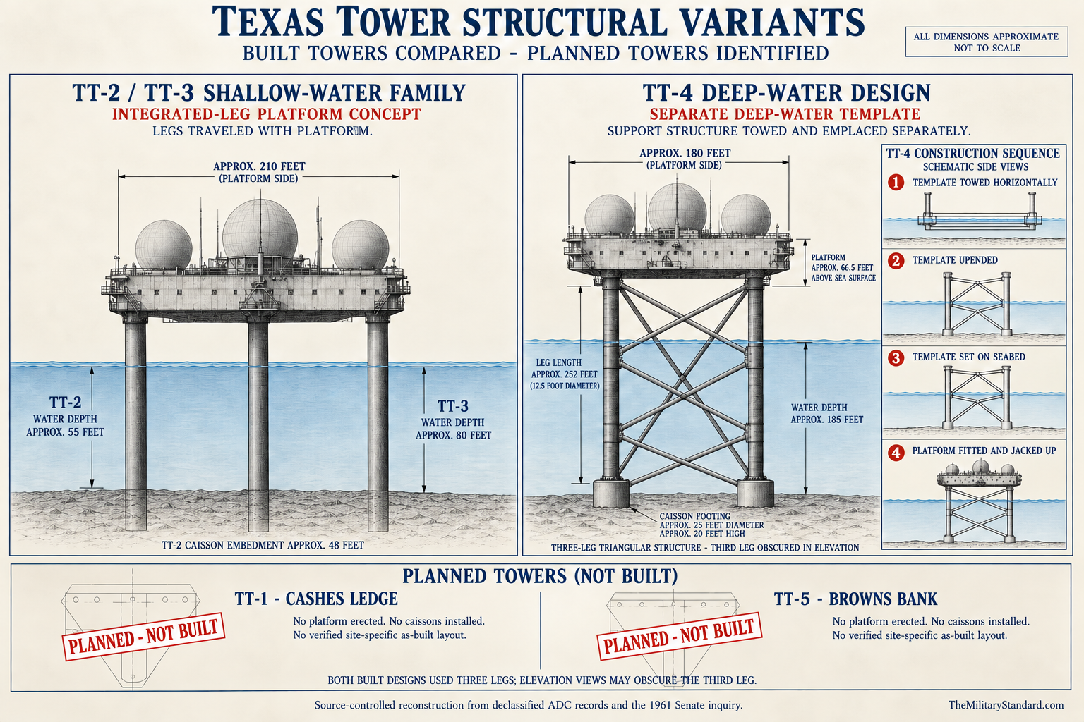
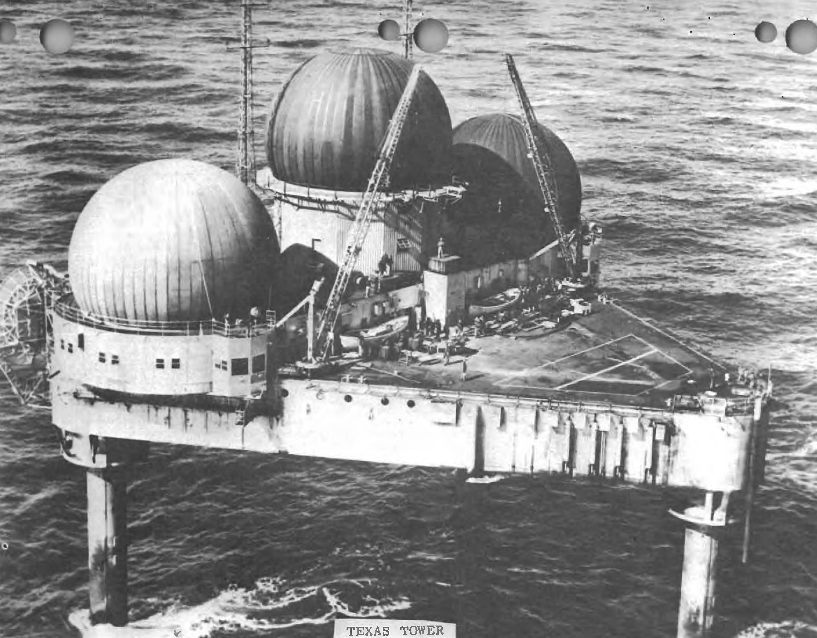
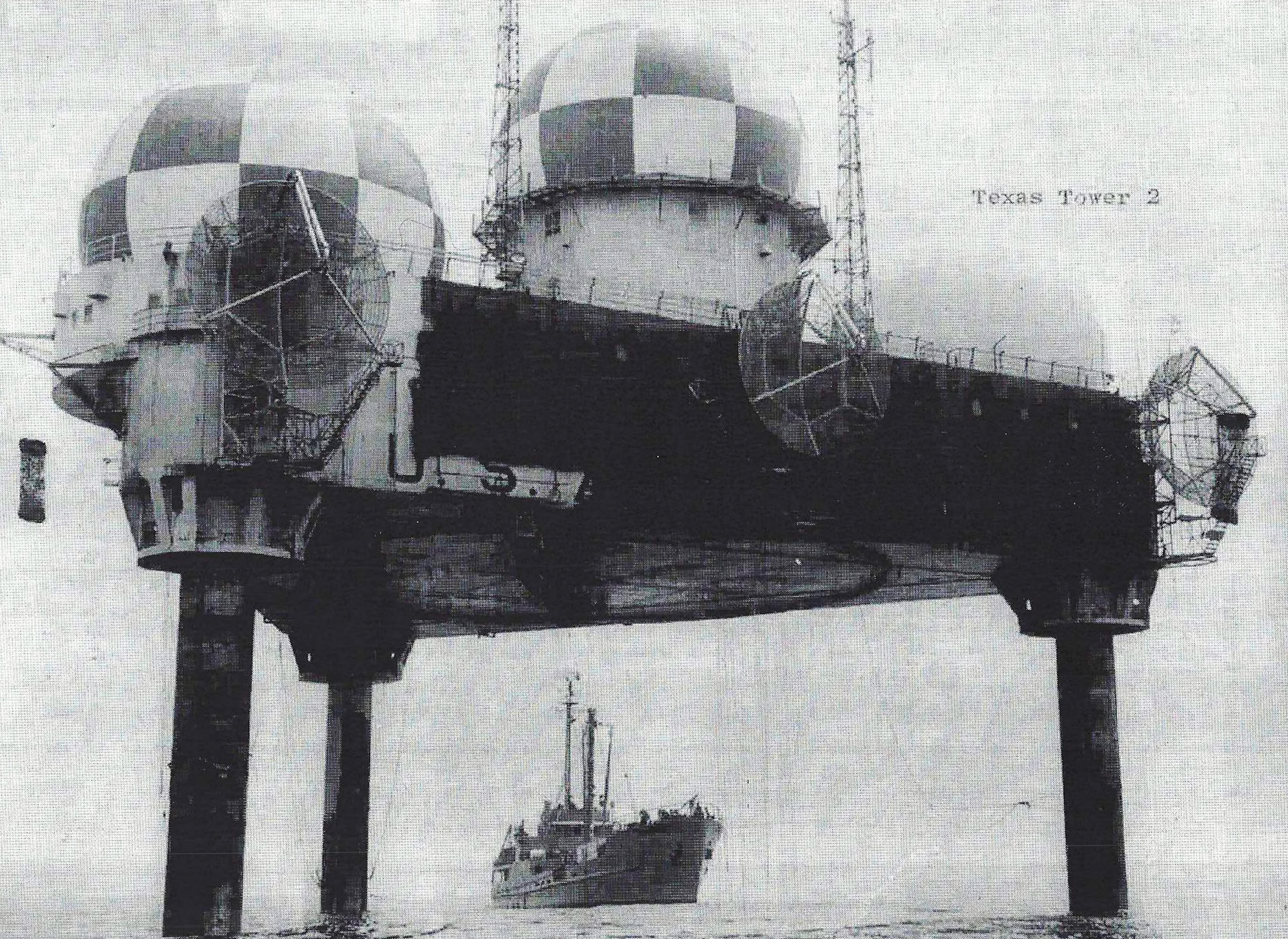
Texas Tower No. 3 was a triangular steel platform with cropped corners, enclosed working decks, an elevated operations area, a helicopter landing surface, and three caisson legs. Program descriptions give sides of approximately 210 feet and a platform body about 20 feet deep, producing roughly one-half acre of working surface. Such dimensions are approximate family figures, not a surveyed boundary or proof that every compartment matched TT-2. The completed structure had to combine radar station, power plant, workshop, warehouse, barracks, clinic, communications center, and aviation facility.
The platform contained machinery and storage on its lower level, living and administrative rooms above, and radar operations spaces on the raised portion. Crew facilities included sleeping quarters, galley and mess, offices, sanitation, medical space, food storage, recreation areas, and a library. Pumps, tanks, generators, ventilation, heating, air conditioning, workshops, and spare-parts storage kept both people and electronics functioning. No single system could be understood apart from the artificial habitat that supported it.
Three pressurized radomes gave TT-3 its characteristic silhouette. A search radar occupied the principal dome, and two height finders occupied the others. Pressurization allowed the antennas to rotate and scan while the domes moderated wind and weather exposure. Search radar supplied range and azimuth; height-finder crews supplied altitude; identification and plotting equipment aided classification; communications and data-transmission systems converted those local measurements into information usable ashore.
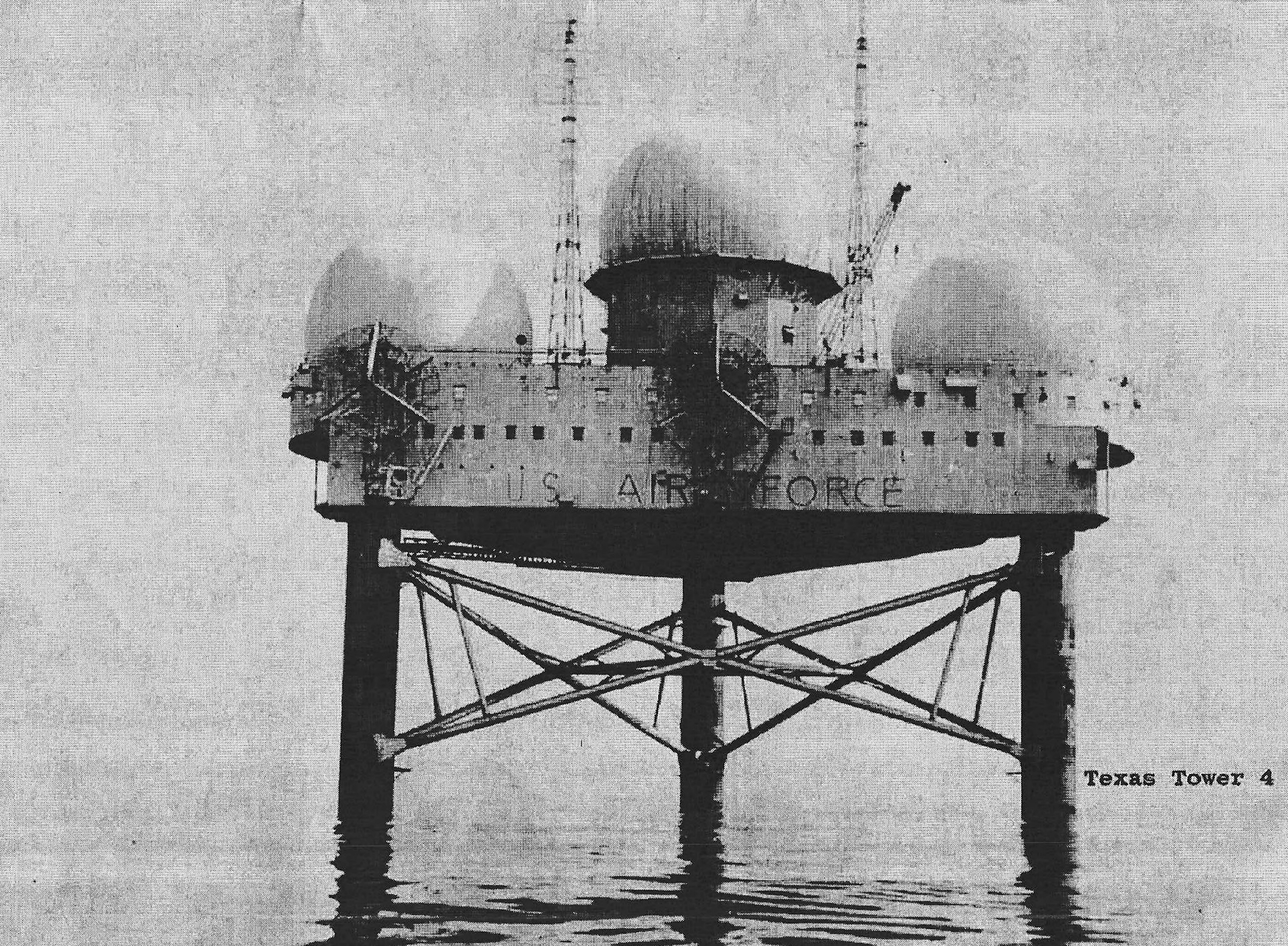
The three long caisson legs passed through the water column and into the seabed, raising the working platform above ordinary wave action. Later towers incorporated experience from TT-2, including concern for leg length, fuel capacity, structural loads, and offshore installation methods. Public summaries differ on exact TT-3 leg dimensions and embedded depth, so this history does not transfer TT-2 measurements as though they were TT-3 as-built drawings. The essential point is that the tower's safety depended on both steel continuity and stable soil around each foundation.
Leg and lower-deck spaces also formed part of the utility system. Fuel, water, piping, electrical distribution, pumps, and treatment machinery had to function despite vibration and salt exposure. Seawater distillation produced fresh water, while stored fuel supported diesel generation and aviation-related needs. Reserve food, lubricants, parts, and emergency equipment allowed the station to continue through weather delays. Isolation was an expected operating condition, so redundancy was part of mission design rather than a luxury.
Electrical power was generated continuously by a bank of diesel sets sized to permit maintenance and failure tolerance while radars, communications, pumps, lights, galley, ventilation, and climate control remained in use. Program histories commonly describe eleven 250-kilowatt generators for a completed tower, with only part of the bank carrying the normal load. This figure is a program-level configuration and should be checked against TT-3 equipment records before being treated as a serial-level inventory. It nevertheless illustrates the industrial scale of an offshore radar station.
Construction and Emplacement
TT-3 was fabricated in the former New England Shipbuilding Corporation East Yard basin at South Portland, Maine. This location is frequently confused with the Fore River shipyard at Quincy, Massachusetts, where TT-2 was built, because both construction accounts use familiar New England shipbuilding place names and Fore River references. The TT-3 platform belongs to South Portland's wartime shipyard landscape. Contemporary local photographs and newspapers are therefore central evidence for the tower's launch and tow.
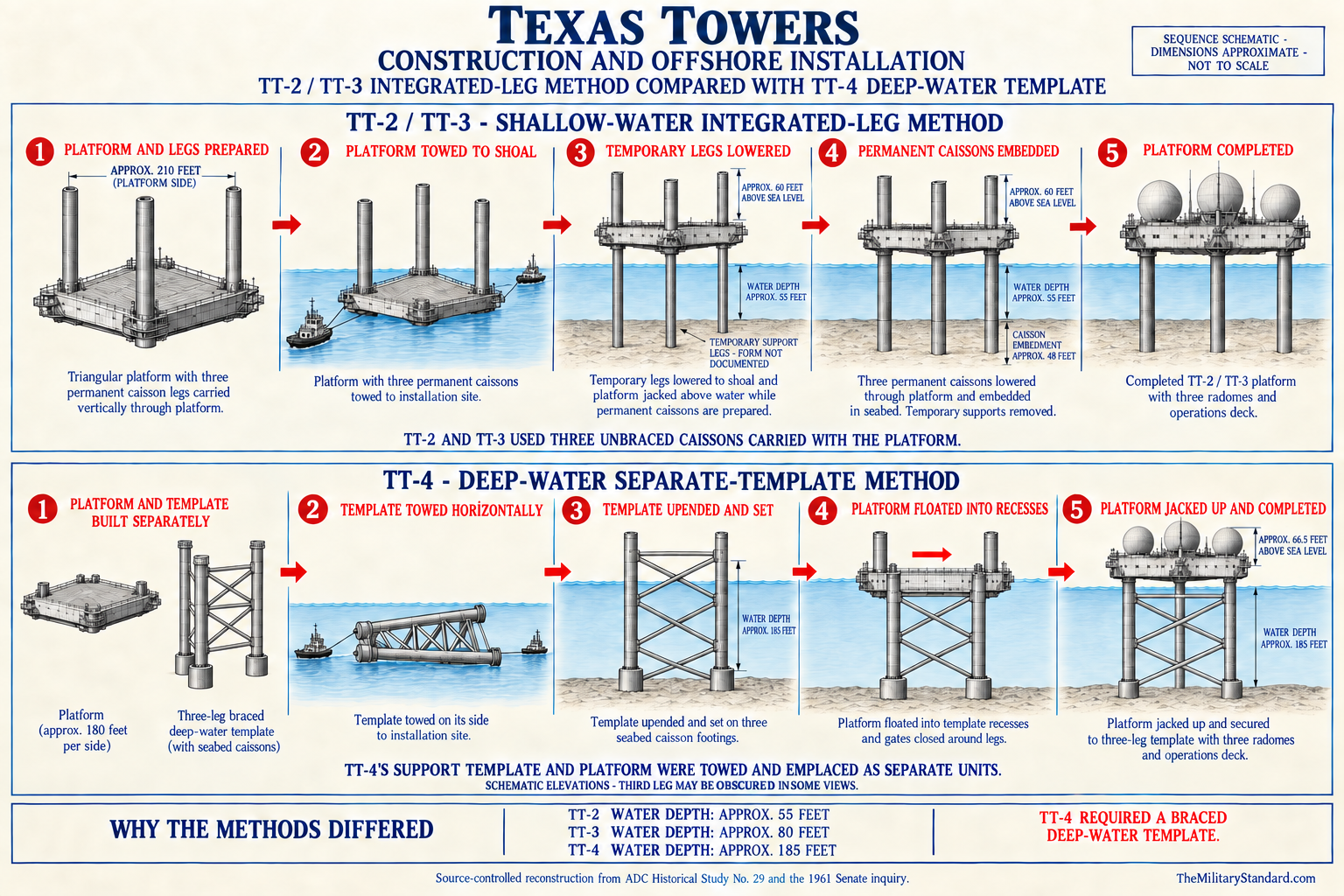
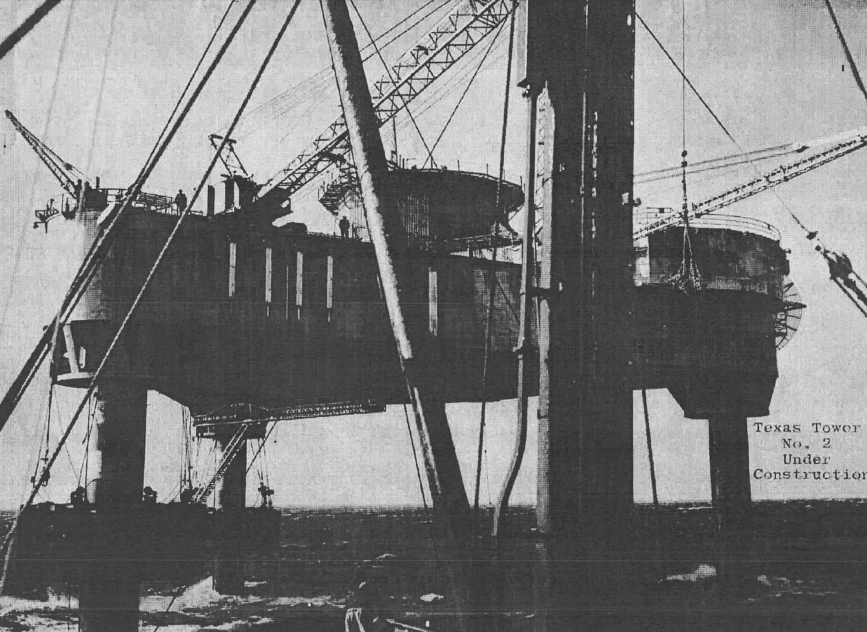
A joint venture of J. Rich Steers, Inc. and Morrison-Knudsen carried the TT-3 construction and emplacement work. Navy-managed contracts translated the common program design into fabrication, fitting-out, tow preparation, and offshore erection. The work required shipyard skills, heavy structural fabrication, specialized towing, pile and caisson operations, diving, marine surveying, and coordination with Air Force electronics installation. Treating the tower as only a radar project overlooks the large maritime construction enterprise that made the radar position possible.
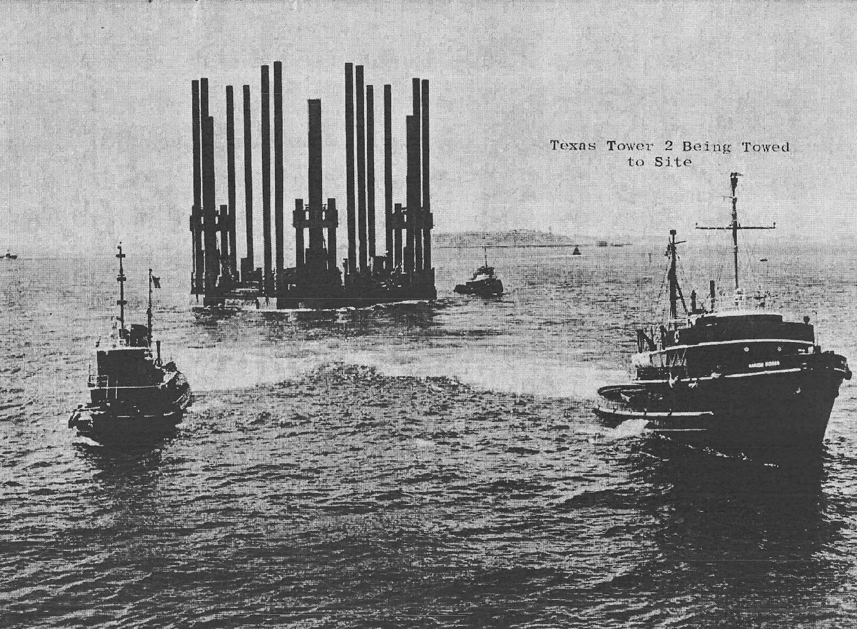
Air Defense Command's official chronology records the TT-3 launch on August 7, 1956. A contemporary Moran Tow Line account says the structure left South Portland on August 9 behind the tugs Julia C. Moran and M. Moran. These dates are compatible if launch from the construction position preceded final tow departure. The tower was moved down the New England coast and out to Nantucket Shoal, where contractors established it during August. The Congressional Record similarly states that the tower was placed on site that month.
At the shoal, crews positioned the floating structure, lowered temporary supports, raised the platform, and installed the permanent caissons into the seabed. Offshore work had to proceed around weather, sea state, current, visibility, and the limits of cranes, barges, tugs, and diving teams. A small positional error or construction delay had consequences far beyond an ordinary land project because the platform itself, the work force, and heavy equipment were exposed while the station remained incomplete.
The Air Force accepted beneficial occupancy on November 29, 1956. Beneficial occupancy meant that the service could take possession and proceed with installation, testing, training, maintenance, and correction of deficiencies. It did not mean that every radar channel, communications circuit, SAGE interface, and structural closeout item was complete. The official operating table's October 1958 manual-operations date demonstrates the long interval between occupying a platform and fielding a dependable operational radar station.
Construction continued in functional terms after occupancy. Radomes, antennas, data and communication equipment, power distribution, shops, living services, safety gear, and aviation support all required testing in the actual marine environment. Vibration, corrosion, electromagnetic interference, and access limitations could not be solved entirely at the shipyard. The tower became a military installation through a sequence of acceptance, equipment activation, calibration, crew training, and network integration rather than one ceremonial opening.
Radar, Data, and Communications Systems
The Air Defense Command table (link to PDF in Sources & References section at bottom of page) is the controlling equipment chronology used here. It lists two AN/FPS-6 height finders and an AN/FPS-20 search radar as activated in October 1958. The same table shows an AN/FPS-20A configuration in 1960, replacement by AN/FPS-67 in 1961, removal of the AN/FPS-20A in 1961, and inactivation with the two AN/FPS-6 sets and AN/FPS-67. This sequence ties equipment changes to operations more securely than undated secondary lists.
Several later summaries state that an AN/FPS-3 search radar and two AN/FPS-6 height finders began installation after beneficial occupancy in November 1956. That claim is plausible because the completed tower program originally used the AN/FPS-3 family, but the consolidated ADC table does not show a TT-3 AN/FPS-3 activation entry. The history therefore records it as an initial installation report rather than a proven period of operational service. It does not invent a readiness date or assume the set carried the station's official mission.
The AN/FPS-20 and AN/FPS-20A designations describe stages of the main search-radar family. The AN/FPS-67 was a further improved configuration derived from that lineage. The changes were intended to improve reliability, maintainability, performance, and compatibility with evolving data systems, not to give the tower a new geographic mission. Search-radar modernization kept TT-3 useful while the wider network moved from manual reporting toward computerized track processing.
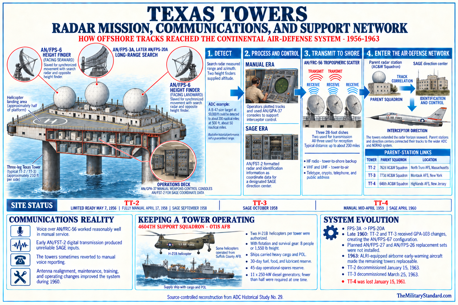
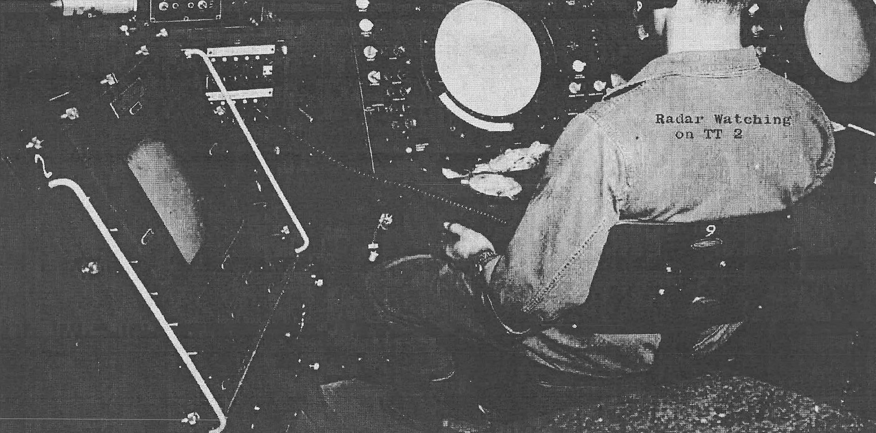
The two AN/FPS-6 height finders supplied the altitude dimension that a conventional two-dimensional search radar did not directly provide. Operators slewed a height finder toward a detected target and measured elevation so that controllers could build a three-dimensional track. Two sets gave capacity and redundancy for a busy or uncertain air picture. Their continued presence through shutdown shows that height determination remained a core tower function even while the main search set changed.
Associated systems included identification friend or foe, local scopes and plotting equipment, timing and communications gear, and SAGE data-transmission equipment. Program histories associate the AN/FST-2 family with converting radar information into digital messages for direction centers. Precise TT-3 configuration dates and equipment suffixes are not complete in the public record reviewed here, so the history describes functions where model-level evidence is incomplete. That approach avoids turning a common Texas Tower equipment list into a false station inventory.
Long-distance communications connected the isolated platform with shore. Program accounts describe AN/FRC-56 tropospheric-scatter equipment and large vertical parabolic antennas for the tower system, supplemented by high-frequency backup and VHF or UHF tower-to-air circuits. These links carried radar data, voice, command traffic, weather, logistics coordination, and emergency messages. Radar detection had little defense value if a track could not reach the mainland control system, making communications reliability as important as antenna rotation.
Electronic density created technical problems. Powerful transmitters, receivers, generators, motors, and control circuits operated within a compact steel structure rather than across a spacious land station. Crews had to manage interference, grounding, heat, vibration, salt contamination, and restricted maintenance access. Atmospheric conditions over the shoals could also bend radar energy, cause anomalous propagation, or create clutter. Equipment performance was therefore the combined result of hardware, maintenance, environment, and communications, not a catalog range figure alone.
Operations and SAGE Integration
Air Defense Command's historical table gives October 1958 as the beginning of TT-3 manual operations. Manual operation required people to detect returns, correlate search, height, and identification information, maintain plots, report tracks, and assist weapons-control activity without relying entirely on automatic data processing. The station had been physically occupied since 1956, but the 1958 milestone represents the documented point at which its radar equipment entered the command's operating sequence.
Secondary histories often use June 1, 1958 as the beginning of the 773d Radar Squadron's TT-3 relationship. That date may refer to organization of the offshore detachment or a unit-accounting change rather than full manual operational readiness. No underlying special order was recovered in this research. Both dates are therefore retained with labels: June as a commonly reported unit milestone, and October as the official ADC table's manual-operations milestone.
The tower became operational in SAGE in April 1960. SAGE converted radar reports into digital data and combined them at direction centers with tracks from other sensors. Controllers could then evaluate the regional air picture, assign interceptors, and send guidance through the automated system. TT-3's contribution was not simply a larger circle on a map. It was an outward sensor position whose data could be correlated with coastal radars, airborne warning aircraft, picket forces, identification information, and fighter readiness.
The operational tower watched normal air traffic as well as unknown or potentially hostile tracks. Crews had to distinguish weather, propagation anomalies, friendly traffic, maintenance effects, and real targets while maintaining readiness around the clock. The station's remote location made local judgment especially important because a mainland technician could not arrive quickly. Radar operators, controllers, communicators, power specialists, and maintenance personnel collectively produced each usable report.
The radar horizon still limited low-altitude detection. Offshore placement moved that horizon eastward and southward, but it did not abolish the curvature of the earth or the need for airborne sensors. High targets could be detected at much greater range than low-flying aircraft, and ducting over the ocean could either extend or distort apparent coverage. Texas Towers therefore supplemented, rather than replaced, radar picket ships and EC-121 airborne early-warning patrols.
SAGE also changed the meaning of an outage. In the manual era a tower might still telephone or radio selected tracks if part of its equipment failed. In the automated network, failure of data-processing or long-distance circuits could remove the station's timely input even when local radar still displayed returns. Maintenance standards thus extended from the antenna and transmitter through encoders, communication terminals, power, and shore interfaces. Reliability was an end-to-end network property.
By 1962, the tower's military value was judged against systems that could provide the same network function without a fixed offshore foundation. Airborne Long Range Input modified EC-121H aircraft so their radar information could feed SAGE. This offered mobility and a different low-altitude geometry, although it required sustained aircraft operations. The arrival of ALRI did not prove that TT-3 had never worked; it meant that a safer and more adaptable way to supply seaward radar data was becoming operational.
Organization, Command, and Support
The 773d Radar Squadron at Montauk Air Force Station is the principal operational parent associated with TT-3. The squadron operated the eastern Long Island radar site and supplied personnel or command relationships for the offshore detachment. TT-3 remained a distinct installation with its own site code and platform, not an annex physically located at Montauk. The parent relationship connected offshore radar work to an established unit able to provide supervision, training, records, and continuity.
The 4604th organization at Otis Air Force Base supplied the specialized Texas Tower support system. Air Defense Command's historical table notes that support responsibility transferred from the 762d Aircraft Control and Warning Squadron at North Truro to the 4604th Aircraft Control and Warning Squadron at Otis on October 8, 1956. It then records redesignation as the 4604th Support Squadron in December 1956. Secondary sources disagree between December 1 and December 31, so this history does not assign a more exact date than the primary table supports.
Otis support covered far more than paperwork. The support squadron coordinated helicopters, marine lift, heavy supplies, fuel, parts, maintenance assistance, personnel movement, medical response, and emergency action. It created the shore base that an offshore installation lacked. A radar squadron could operate scopes and maintain equipment, but it could not sustain a small industrial island without aircraft, vessels, warehouses, maintenance shops, contracting, weather support, and administrative services.
Suffolk County Air Force Base also entered the tower transportation network. Program planning placed some H-21 helicopters there while the larger support organization centered at Otis. Montauk's proximity to Long Island made it the logical operational parent, but proximity alone did not replace centralized tower logistics. The division of functions among TT-3, Montauk, Otis, and Suffolk demonstrates why the station must not be reduced to one squadron name.
Higher headquarters changed as the northeastern air-defense system evolved. Air Defense Command, Eastern Air Defense Force, numbered air divisions, sectors, and SAGE direction centers organized the station's reporting and control relationships. Exact assignment dates require unit orders and command histories beyond the public set reviewed here. The durable operational fact is that TT-3 contributed to the northeastern continental defense network rather than operating as an independent ocean surveillance post.
Staffing figures vary by date and definition. A widely repeated mature complement is six officers and forty-eight airmen, while the official Cuban Crisis history says a tower's usual complement was approximately eighty people and records fifty-three men returning to TT-3 after one evacuation. Contractors, inspectors, transient support personnel, and changing operational requirements can explain part of the difference.
No complete roster, commander chronology, duty-position chart, detachment order, or daily strength report was recovered. Veterans' materials preserve names and personal experience, but they do not replace official manning documents. The organizational account distinguishes what is directly established from what remains a research lead. That is especially important for an offshore station where assigned unit, duty location, support unit, and temporary contractor presence could all appear in the same event.
Logistics, Transportation, and Life Aboard
Helicopters provided the fastest routine connection to shore. The Air Force authorized two H-21B helicopters per tower, with four based at Otis Air Force Base and two at Suffolk County Air Force Base for the Texas Tower system. Flotation and survival equipment reduced the H-21B's theoretical load to about eight passengers or 1,550 pounds of freight. Weather, visibility, aircraft availability, deck conditions, weight, and fuel imposed additional practical limits.
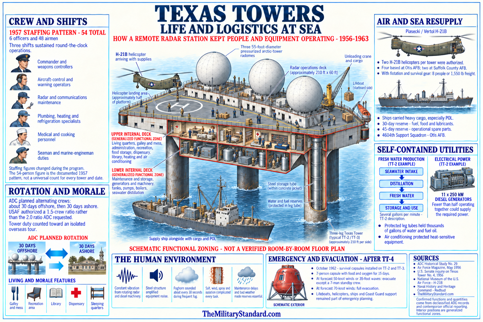
Surface vessels carried heavy cargo, bulk fuel, lubricants, and supplies that helicopters could not move efficiently. Transfer from a moving ship to a fixed platform in Atlantic swell required cranes, rigging, schedules, and crews trained for marine handling. A normal resupply mission could become hazardous when wind or sea state increased. The tower therefore carried at least a 30-day reserve of fuel, food, and lubricants and approximately 45 days of spare parts for operational equipment.
The helipad gave the station an aviation facility but not the flexibility of an airfield. A helicopter could land only when visibility, wind, deck condition, and aircraft limits permitted. Fog was common on Nantucket Shoals, and a foghorn sounded at regular intervals, adding another vibration and noise source. Medical evacuation, personnel rotation, mail, fresh food, and technical assistance could all be delayed, so tower personnel lived with a degree of isolation uncommon at continental radar sites.
Daily life combined military routine with the physical sensations of a steel structure at sea. Rotating antennas, diesel engines, pumps, ventilation machinery, waves, and wind kept the platform in near-continuous vibration. The legs transmitted and amplified underwater and structural sounds, making the tower behave like a large resonating instrument. Crews learned which motions and noises were ordinary, a skill that helped them work but could also make judgments about changing structural behavior psychologically difficult.
Living areas included bunks, mess facilities, recreation space, a dispensary, and a library, but privacy and escape from machinery were limited. Watch schedules continued through nights, weekends, storms, and holidays because the air-defense picture could not be suspended. Contemporary newsletters and later recollections record both hardship and strong community: card games, films, amateur radio, shared meals, maintenance work, inspections, jokes, and anticipation of the next rotation all formed part of tower culture.
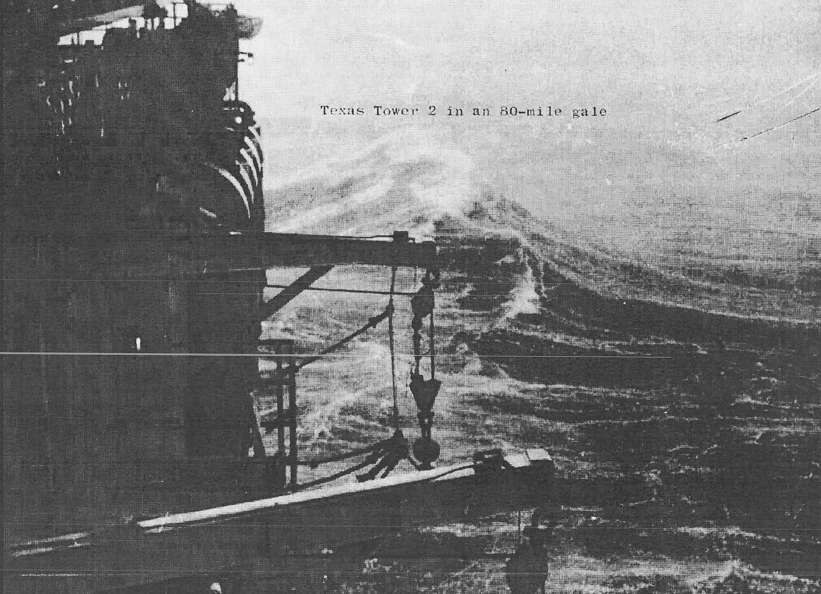
Weather shaped almost every activity. Fog interfered with flight operations and visual navigation, storms restricted ship transfers, salt attacked metal and electrical connections, and winter seas produced vibration and concern that could not be replicated in shore training. Emergency procedures had to address fire, power failure, medical injury, failed water production, helicopter accident, loss of communications, and structural danger. Readiness depended on keeping both the radar mission and the artificial habitat functioning.
Structural Experience and Safety
TT-3 operated in shallower water than TT-4 and did not share every feature of the tower that collapsed, but it remained a large fixed structure exposed to storms, corrosion, vibration, and seabed change. Radar antennas and diesel machinery imposed repeating loads from above while waves, current, and sediment movement acted below. Structural safety depended on inspection of steel, connections, caissons, bracing, and the soil surrounding the legs. Maintenance could reduce risk but could not remove the ocean environment.
The January 15, 1961 collapse of TT-4 transformed the institutional meaning of tower safety. Twenty-eight Air Force and civilian personnel were lost after a history of structural damage and repeated repair. TT-3 was not proved to be on the same failure path, and it would be inaccurate to describe it as another TT-4 waiting to fall. The disaster nevertheless showed that ambiguous responsibility, optimistic risk judgments, delayed evacuation, and inadequate understanding of structural behavior could have fatal consequences.
After TT-4, Air Force and Navy officials intensified inspection, review, and evacuation planning for TT-2 and TT-3. Emergency capsules and revised procedures offered some protection, but they did not make evacuation simple. Helicopters could be grounded by the same weather that threatened the platform, while vessels faced dangerous approaches in high seas. A decision to keep the radar operating during a storm therefore carried a direct personnel risk that a mainland site did not present.
The most consequential TT-3 evidence comes from the Cuban Missile Crisis. On November 16, 1962, severe weather made the station non-operational at 2105Z and reduced manning to seven because of high waves. Inspectors arrived after conditions eased on November 18, and fifty-three men returned. Their return did not end the concern. Underwater inspection found severe scouring and erosion around the legs, leading to another evacuation on November 20.
The timing sharpened the operational dilemma. The national defense system was at heightened readiness during the crisis, so losing a seaward radar input was undesirable. Yet sending a full crew back onto a structurally questioned platform could not be justified solely by alert demands. Air Defense Command kept a seven-person presence while evaluating future use. The episode demonstrates that TT-3's final decline came from a real conflict between mission availability and acceptable life safety.
Scour was not cosmetic erosion. Moving water removed seabed material around the caissons, reducing lateral support and potentially changing load distribution. Repair required underwater engineering, heavy construction, weather windows, and continuing monitoring. Even if technically possible, such work had to be compared with the tower's remaining strategic value and with the cost of an alternative sensor system. By late 1962, the balance had shifted away from major reinvestment in the fixed platform.
Role in the Wider Military Network
TT-3 extended the northeastern radar line into the Atlantic between the New England shore network and the approaches watched by airborne and shipborne sensors. Its value was geometric: a target could cross the tower's radar horizon before reaching a coastal radar horizon, giving direction centers additional time to classify the track, alert commanders, prepare fighters, and arrange interception. The tower did not constitute an independent shield. It supplied one earlier and differently positioned view to a layered defense system.
Montauk Air Force Station and the 773d Radar Squadron linked the offshore detachment to a mainland operational organization. Otis Air Force Base and the 4604th Support Squadron linked it to helicopters, maintenance, supply, administration, and emergency response. SAGE direction centers converted its data into a regional air picture, while fighter-interceptor units supplied the aircraft that could act on that picture. Each organization performed a different part of the defense mission.
Navy radar picket ships and Air Force EC-121 airborne early-warning aircraft worked in the same seaward-warning problem. Ships and aircraft could move and could sometimes see low-flying targets beyond a fixed tower's local horizon, but they consumed fuel, crews, maintenance, and continuous operating effort. TT-3 offered persistent equipment and a stable geographic reference but could not relocate or avoid a storm. The system used complementary sensors because none supplied perfect coverage alone.
SAGE made TT-3 more valuable as a data source and more dependent on communications. Automated reporting allowed computers and controllers to correlate the tower's track with reports from other stations and assign weapons efficiently. A radar return seen offshore became militarily useful only after identification, height information, encoding, transmission, correlation, and command decisions. This chain explains why a communications failure could remove TT-3 from the effective network even if its search antenna still turned.
ALRI eventually reproduced the essential network input from modified EC-121H aircraft. Airborne radars could extend coverage, respond to changing threats, and avoid permanent exposure of a large crew on a deteriorating foundation. The change was not simply a shift from bombers to missiles. It was a replacement of one seaward sensor architecture by another within SAGE, combined with declining tolerance for structural risk and high maintenance cost. TT-3 therefore marks a technological transition inside the air-defense network.
Decommissioning and Demolition
The two remaining towers had long been scheduled for deletion when ALRI became operational. Storm interruption, seabed scour, repair cost, and the approach of the airborne capability accelerated the decision. On January 2, 1963, the Joint Chiefs of Staff directed immediate inactivation of TT-2 and reduced TT-3 to a seven-person security crew, with the ability to return to full operation within twenty-four hours. TT-3 was to close when the first ALRI station became operational.
On March 6, Air Defense Command advised that ALRI-equipped EC-121H aircraft could satisfy the minimum Alpha and Bravo alert requirements of NORAD Regulation 55-3. The command expected higher requirements to follow. NORAD concluded that continuing tower maintenance cost and risk to life no longer justified delay. On March 25, 1963, TT-3 was decommissioned and its equipment turned off. This official sequence is more precise than a general claim that changing missile threats made the tower obsolete.
Decommissioning ended the radar mission but did not immediately remove the structure. Air Force and contractor teams stripped radar, communications, and other usable or sensitive equipment. Security, property accountability, safety preparation, contracting, and demolition continued after the operating unit left. The station's close date and the platform's removal date therefore describe different events. March 1963 belongs to military operations; August 1964 belongs to structural disposition.
The earlier TT-2 demolition failed to recover that platform, which sank after its legs were cut. Planners gave TT-3 additional flotation. Program histories state that the bottom deck was pumped full of urethane foam and sealed so that the body would rise after separation. On August 6, 1964, explosives severed the three legs from below. The platform dipped or plunged into the sea, then returned to the surface, allowing tugs to take it in tow.
Later accounts state that the salvaged platform went to the former Federal shipyard at Kearny, New Jersey, where the Lipsett Division of Luria Brothers handled it for scrap after possible reuse was considered. The Moran Tow Line periodical provides contemporary towing context, while later histories supply the Kearny disposition. No complete demolition contract, salvage inventory, or final scrapping certificate was recovered here. The destination and scrapping are therefore well-supported secondary conclusions rather than fully reconstructed property records.
The removal made TT-3 unique among the completed towers. TT-4 collapsed and remains on the seabed, and TT-2 sank during demolition. TT-3's main platform was recovered. That distinction means a generic statement that all Texas Towers are offshore wrecks is incorrect. It also does not prove that the Nantucket site is empty, because severed caisson portions, buried foundations, cables, anchors, fragments, or construction material may have remained after the platform departed.
Current Condition, Environment, and Preservation
The current TT-3 location is open Atlantic water over Nantucket Shoals. There is no surviving staffed station, radome, helipad, barracks, radar antenna, or complete platform at the historical point. The platform's successful 1964 tow distinguishes the site from the known TT-2 and TT-4 wreck areas. Modern satellite imagery cannot verify seabed conditions, and a rounded historical coordinate cannot establish that no structural remains lie nearby.
No current NOAA Coast Pilot passage identifying a TT-3 tower wreck at the representative point was located in this research. NOAA has retired its older AWOIS public service and directs users to continuously maintained Electronic Navigational Chart data for current wrecks and obstructions. That absence from the narrative documents reviewed here is not proof of a clear seabed. A current ENC query and a modern hydrographic or side-scan survey are the proper tools for identifying charted and uncharted residual hazards.
Historical survey H08600 contributes regional bathymetric context from 1961 but does not, by itself, settle the post-1964 disposition of every leg or fragment. Modern bathymetric compilations include that survey among data for the Montauk to Nantucket Shoals area. Because the survey predates removal, it cannot prove present condition. The research record needs a later high-resolution survey specifically covering the construction point before it can describe remaining foundations, debris spread, burial, or clearance with confidence.
No tower-specific FUDS, Defense Environmental Restoration Program, Superfund, or other public cleanup project was identified. TT-3 stored diesel fuel, lubricants, electrical equipment, coatings, batteries, and other materials typical of its era. Equipment removal and platform recovery reduced some potential sources. Possible buried or scattered material remains an environmental and archaeological research question rather than an established cleanup site.
The broader Nantucket Shoals marine environment supports navigation, fishing, scientific research, and protected species. Any survey, anchoring, diving, salvage, or artifact removal could implicate federal navigation, fisheries, offshore-resource, environmental, safety, and cultural-resource rules. The historical point is not an access authorization or safety recommendation. Anyone using the location at sea must rely on current official charts, notices, weather, and applicable law.
The National Marine Fisheries Service water-temperature series demonstrates a noncombat use of the occupied platform. Observations from 1958 through at least 1960 compared Nantucket Shoals with Georges Shoal and other offshore stations. The tower thus provided a stable observation point in a region where long continuous measurements were difficult.
Chronology
- 1946 through 1951 Air Defense Command and related organizations studied ways to extend warning seaward beyond the practical horizon of coastal radar.
- August 1, 1952 MIT Lincoln Laboratory outlined a fixed offshore radar-platform concept modeled generally on Gulf Coast oil structures.
- September 1952 Early planning examined mission, manning, communications, maintenance, and the relationship between fixed platforms and other seaward-warning forces.
- 1952 through 1953 Air Force, Navy, and Lincoln Laboratory staffs refined the concept and identified five shallow Atlantic sites.
- August 24, 1953 Air Defense Command documentation continued to define the operational requirement for Texas Towers.
- Autumn 1953 The Air Force authorized a five-tower program including Nantucket Shoal as TT-3.
- November 16, 1953 An Air Force planning guide set implementation assumptions for the tower system.
- January 1954 Five strategically located platforms remained in the approved program.
- March 1954 The Navy Bureau of Yards and Docks completed common plans and specifications for the offshore structures.
- July 1954 DeLong and Raymond interests received a contract for site core drilling and related investigation.
- Summer 1954 Marine surveys and borings examined the proposed tower sites, including Nantucket Shoal.
- October 1954 A feasibility report supported construction while identifying demanding offshore engineering conditions.
- December 1954 TT-2 at Georges Shoal was selected as the prototype from which later construction would learn.
- 1955 TT-2 construction, emplacement, and storm experience supplied lessons relevant to the later TT-3 design and procedures.
- 1955 through early 1956 Navy-managed contracts and the J. Rich Steers and Morrison-Knudsen joint venture advanced TT-3 fabrication at South Portland, Maine.
- 1956 The former New England Shipbuilding Corporation East Yard basin served as the construction location for the TT-3 platform.
- August 7, 1956 Air Defense Command's chronology records the launch of Texas Tower No. 3.
- August 9, 1956 A Moran company periodical records departure from South Portland behind the tugs Julia C. Moran and M. Moran.
- August 1956 The contractors towed TT-3 to Nantucket Shoal and placed it on site.
- October 8, 1956 Support responsibility transferred from the North Truro organization to the 4604th Aircraft Control and Warning Squadron at Otis Air Force Base.
- November 29, 1956 The Air Force accepted beneficial occupancy of TT-3.
- December 1956 The 4604th organization became the 4604th Support Squadron; sources differ on the precise day.
- Late 1956 through 1957 Crews installed, tested, calibrated, and corrected radar, communications, power, and station-support systems.
- 1957 TT-3 developed as an occupied military installation while the manual radar and shore-link systems approached operational readiness.
- June 1, 1958 Secondary unit histories commonly begin the 773d Radar Squadron's TT-3 relationship on this date.
- March 1958 National Marine Fisheries Service observations at the Nantucket Shoals tower began producing a continuous surface-water-temperature series.
- October 1958 The official ADC table records TT-3 manual operations and activation of AN/FPS-20 search radar with two AN/FPS-6 height finders.
- 1958 through 1959 The tower supplied manual seaward warning and height data while support and environmental observation continued.
- 1959 Published federal scientific observations compared Nantucket Shoals water temperatures with the Georges Shoal tower and other stations.
- 1960 The official equipment table records an AN/FPS-20A search-radar configuration at TT-3.
- April 1960 TT-3 became operational in the SAGE network.
- 1960 A federal scientific table printed an observation coordinate different from the common Air Force TT-3 point, creating a continuing location question.
- 1961 The official ADC table records AN/FPS-67 replacing the AN/FPS-20A search configuration.
- January 15, 1961 Texas Tower No. 4 collapsed in a winter storm with twenty-eight military and civilian personnel aboard.
- 1961 The TT-4 loss caused intensified structural review, inspection, emergency planning, and evacuation concern for TT-2 and TT-3.
- 1961 through 1962 TT-3 continued SAGE radar service with AN/FPS-67 and two AN/FPS-6 sets.
- 1962 Air Force and Navy authorities weighed continuing structural and maintenance requirements against changing seaward-warning alternatives.
- November 16, 1962 Severe weather made TT-3 non-operational at 2105Z and reduced its manning to seven people during the Cuban Missile Crisis.
- November 18, 1962 Inspectors reached the tower after conditions eased, and fifty-three men returned.
- November 18 through 20, 1962 Underwater inspection found severe scouring and erosion around TT-3's legs.
- November 20, 1962 TT-3 was evacuated again because of the foundation findings.
- Late November through December 1962 The tower remained at seven-person manning while Air Force leaders evaluated future use.
- January 2, 1963 The Joint Chiefs of Staff directed immediate TT-2 inactivation and a caretaker posture for TT-3 pending ALRI availability.
- January 8, 1963 The Air Force publicly announced the decision affecting the remaining Texas Towers.
- January 15, 1963 TT-2 was inactivated, leaving TT-3 as the final platform retained in caretaker status.
- March 6, 1963 Air Defense Command advised that ALRI-equipped EC-121H aircraft could meet the minimum Alpha and Bravo alert requirements.
- March 1963 NORAD authorized TT-3 inactivation because continued cost and risk to life outweighed remaining benefit as ALRI approached readiness.
- March 25, 1963 Texas Tower No. 3 was decommissioned and its radar equipment turned off.
- Spring 1963 through 1964 Usable and sensitive radar, communications, and support equipment was removed from the platform.
- September 1963 The failed TT-2 demolition and recovery attempt informed the more conservative flotation plan for TT-3.
- 1964 Demolition planners filled and sealed TT-3's lower deck with urethane foam to improve flotation.
- August 6, 1964 Explosives severed TT-3 from its legs; the platform submerged briefly, resurfaced, and was taken under tow.
- August 1964 The recovered platform was moved toward the New York-New Jersey harbor area for disposition.
- August 11, 1964 Later shipyard histories associate TT-3 with the former Federal yard at Kearny, New Jersey.
- 1964 and after The platform was scrapped rather than preserved or returned to military operation.
- Late twentieth century Veterans and radar-history organizations preserved photographs, newsletters, site data, and personal recollections.
- 2014 NOAA expanded public access to federal wreck and obstruction information while explaining positional limitations in legacy records.
- 2020s NOAA retired AWOIS as an actively maintained service and directed users to ENC Direct for current charted features.
Information sources (39)
- PDFADC Historical Data, 1946-1973 (17.67 MB)
Section III and the Texas Towers table establish TT-3 beneficial occupancy, manual and SAGE dates, radar activation and removal sequence, support footnote, and inactivation.
- PDFA History of Texas Towers in Air Defense, 1952-1964, ADC Historical Study No. 29
Principal official program history for requirements, engineering, construction, equipment, operations, support, safety, closure, and demolition.
- PDFSeaward Extension of Radar, 1946-1956, ADC Historical Study No. 10
Official source for Lincoln Laboratory's 1952 concept, five-site authorization, Navy plans, surveys, feasibility work, and prototype selection.
- PDFA Chronology of Air Defense, 1914-1972, ADC Historical Study No. 19
Official chronology for the August 1956 TT-3 launch and emplacement and the 1963 tower shutdown sequence.
- PDFADC and the Cuban Crisis, ADC Historical Study No. 15
Official account of the November 1962 storm, exact outage time, reduced manning, inspection, severe scour, return of fifty-three men, and re-evacuation.
- PDFNORAD and CONAD Historical Summary, January-June 1963
Official command history for the January 2 directive, caretaker posture, March ALRI assessment, cost and life-risk decision, and March 25 decommissioning.
- WEBAir Defense Command and Antibomber Defense, 1946-1972, ADC Historical Study No. 39
Official strategic and technical context for seaward warning, SAGE, ALRI, and the tower phase-down.
- WEBHistorical Review of North American Aerospace Defense, 1946-1970
NORAD historical study for program and continental-defense context.
- PDFEstablishing Independence, official Air Force history
Government publication with Texas Tower origins, construction responsibilities, and early institutional context.
- PDFU.S. Air Force Bases history
Air Force History and Museums Program reference identifying the three artificial offshore platforms in the Air Defense Command network.
- PDFLeading the Way: The History of Air Force Civil Engineers, 1907-2012
Official Air Force civil-engineering context for the Texas Tower program and its extraordinary offshore support problem.
- WEBInquiry into the Collapse of Texas Tower No. 4. U.S. Senate Committee on Armed Services, 1961
Official testimony, engineering record, organizational responsibilities, risk analysis, and drawings relevant to the entire tower program.
- WEBInquiry into the Collapse of Texas Tower No. 4, digitized hearing
Internet Archive access copy of the official Senate record.
- PDFCongressional Record, June 28, 1961
Official congressional chronology stating that TT-3 at Nantucket Shoals was placed on site in August 1956 by the J. Rich Steers and Morrison-Knudsen joint venture.
- PDFTow Line Magazine, Fall 1964
Moran Towing company periodical with contemporary account of TT-3 construction at South Portland, August 1956 tow by Julia C. Moran and M. Moran, and later salvage context.
- WEBSAGE: Semi-Automatic Ground Environment Air Defense System
MIT Lincoln Laboratory official history of the automated network receiving radar inputs such as TT-3.
- PDFOceanographic Observations, 1958. U.S. Fish and Wildlife Service Special Scientific Report-Fisheries No. 318
Official TT-3 water-temperature series beginning in March 1958.
- PDFOceanographic Observations, 1959. U.S. Fish and Wildlife Service Special Scientific Report-Fisheries No. 359
Official follow-on TT-3 environmental observations.
- PDFOceanographic Observations, 1960. U.S. Fish and Wildlife Service Special Scientific Report-Fisheries No. 406
Official TT-3 series and the separately labeled scientific coordinate.
- WEBWrecks and Obstructions. NOAA Office of Coast Survey
Current official explanation that AWOIS is retired and ENC Direct provides the latest charted feature information.
- WEBNOAA Electronic Navigational Charts
Official description of continuously maintained vector chart data and feature positions.
- WEBCoast Survey Improves Access to Data on Thousands of Wrecks and Obstructions
NOAA explanation of historical wreck records, charting, and positional limitations.
- PDFHydrographic Survey H08600 descriptive report
NOAA survey record for regional 1961 bathymetric context before TT-3 removal.
- PDFMontauk to Nantucket Shoals 30-meter Bathymetric Grid metadata
Northeast Ocean Data record identifying H08600 and other federal surveys used in regional bathymetry.
- WEBHydrographic Survey Data
NOAA Office of Coast Survey official research route for modern and historical survey records.
- WEBHistorical Map and Chart Collection
NOAA Office of Coast Survey access route for period chart research.
- PDF773 Radar Squadron unit history
Air Force unit-lineage compilation used cautiously for Montauk and TT-3 organizational leads.
- PDF4604 Support Squadron unit history
Air Force unit-lineage compilation for the Otis-based Texas Tower support organization.
- WEBTexas Towers Association
Veterans and preservation archive with construction material, photographs, rosters, newsletters, and personal accounts.
- WEBThe Construction
Texas Towers Association synthesis and document gallery for platform design, fabrication, towing, emplacement, equipment, power, communications, and demolition.
- WEBTexas Towers index and ADC Historical Study No. 29 resource page. Radomes, Inc
Access route for photographs, site pages, films, and official-history material.
- WEBTexas Tower No. 3 notes and recollections. Radomes, Inc
Veterans' accounts used for human experience and research leads, not as sole authority for official dates.
- WEBTexas Tower 3
FortWiki secondary synthesis used only to cross-check coordinate, unit, radar, and disposition claims against primary sources.
- WEBTexas Tower 3
Secondary overview used as a lead to South Portland newspaper citations and Kearny disposition, not as the controlling source for disputed details.
- WEBAir Defense. Air & Space Forces Magazine, December 1999
Historical overview of the continental air-defense system and completed towers.
- WEBGlory. Air & Space Forces Magazine, September 1958
Contemporary account and photographs of the Texas Tower system, support, and service conditions.
- WEBAnnual Reports of the Secretary of the Air Force collection
Library of Congress archival route for official reports surrounding tower operation and disposition.
- WEBDeLong Corporation v. Lucas
Federal court opinion preserving construction and estimate context derived from TT-3 experience, used cautiously for contractor history.
- WEBNational Archives Catalog
Federal archival route for Air Defense Command, Navy Bureau of Yards and Docks, construction, unit, and disposal records.