
Otis AFB BOMARC Missile Launch Facility, Massachusetts
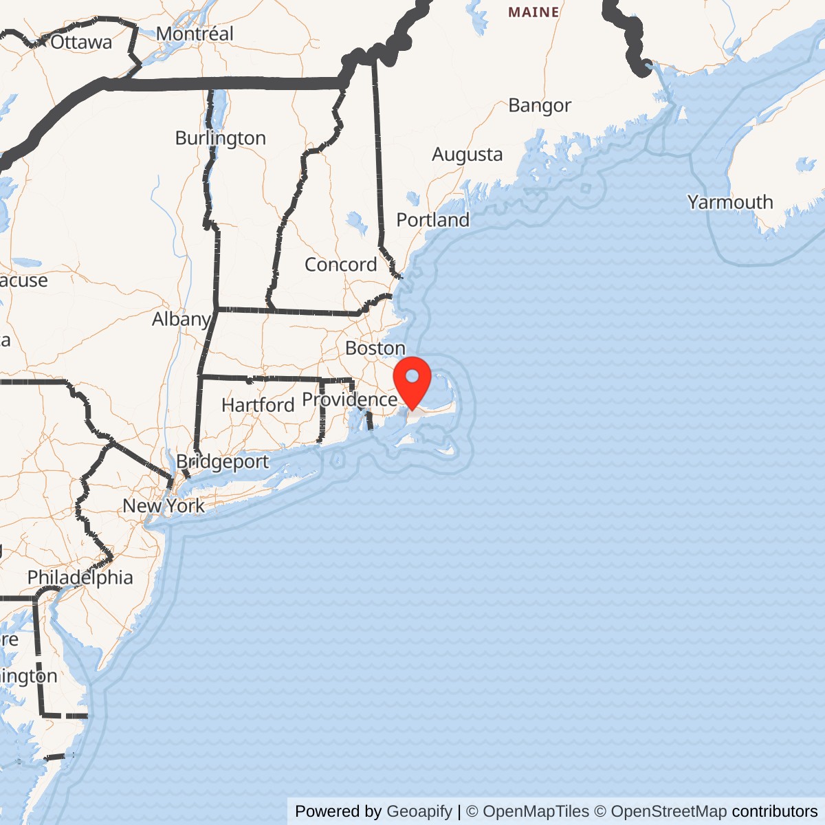
Longitude: -70.53917
Site Number: 26th ADMS; IM-99A/CIM-10A; IM-99B/CIM-10B; CS-10/FS-24
Official Base Website: Former Otis BOMARC Area / Camp Edwards Unit Training Equipment Site
Current Role: Controlled Massachusetts Army National Guard Unit Training Equipment Site within Camp Edwards for maintenance and storage of training vehicles, with a new Camp Edwards Readiness Center project on an adjoining reused BOMARC parcel. The launcher shelters and subsurface utilidor were removed in 2005. CS-10 source controls, groundwater extraction and treatment, long-term monitoring, land-use controls, and five-year review continue under Air Force, EPA, and Massachusetts oversight.
The Otis AFB BOMARC Missile Launch Facility was a separate United States Air Force air-defense installation on the northeastern side of the former Massachusetts Military Reservation, now Joint Base Cape Cod. The 26th Air Defense Missile Squadron operated the site for the defense of New England and the Atlantic approaches. The squadron activated on 1959-03-01, completed training and brought the first BOMARC A element to operational status on 1960-03-25, added a BOMARC B element in 1962, ceased operational alert on 1972-04-01, and inactivated on 1972-04-30. Air Force environmental records use 1973 as the year in which the installation was abandoned or transferred for later Army use, so operational termination and real-property disposition must be treated as different events.
The facility was physically distinct from Otis Air Force Base even though the air base supplied administrative, logistical, transportation, medical, and other support. It occupied a controlled tract north-northwest of the airfield, close to Greenway Road and the Sandwich Gate area. The missile plant, launcher shelters, maintenance buildings, utilities, roads, security perimeter, and underground utility corridor formed an installation with its own hazards and daily operating requirements.
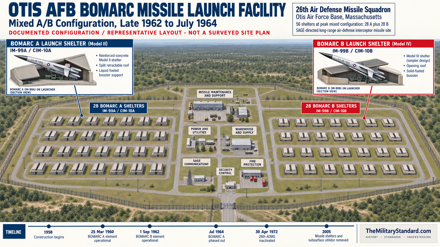
Otis was unusual among operational BOMARC stations because it passed through both major weapon phases. Twenty-eight liquid-booster IM-99A missiles, later redesignated CIM-10A, formed the first alert element. Beginning in June 1962, the squadron introduced the improved solid-booster IM-99B, later CIM-10B, and by 1962-09-01 its B element was operational. For roughly two years the site supported 28 A shelters and 28 B shelters. The A element was phased out in July 1964, leaving 28 B shelters and missiles as the enduring configuration through the final Cold War alert years.
The site's military significance did not end when the missile mission did. In 1978 the Massachusetts Army National Guard incorporated the vacant complex into Camp Edwards and established the Unit Training Equipment Site, or UTES, for the maintenance and storage of armored and wheeled vehicles. Missile shelters and their connecting subsurface utilidor were removed in 2005, but the tract continued to support Army logistics. A state readiness-center project active in the 2020s occupies or adjoins this reused landscape, demonstrating how a specialized Air Force missile plant became part of a continuing National Guard training and support installation.
The environmental record is extensive and indispensable to understanding the physical site. Air Force, EPA, and Massachusetts records identify the former BOMARC and later UTES operations as principal source areas for soil and groundwater contamination designated CS-10 and FS-24. Solvents, petroleum products, missile-related fuels, drainage structures, underground tanks, and later vehicle-maintenance materials produced a complex cleanup history. Source controls, soil removal, soil-vapor extraction, groundwater extraction and treatment, long-term monitoring, institutional controls, and recurring five-year reviews continued long after the launcher shelters disappeared.
Installation Identity, Location, and Boundaries
The name used here is Otis AFB BOMARC Missile Launch Facility. Period and later records also use Otis BOMARC Site, Otis AFB Missile Site, 26th Air Defense Missile Squadron Site, BOMARC Missile Site, Former BOMARC Area, UTES/BOMARC, and CS-10/FS-24. Environmental documents frequently expand BOMARC as Boeing Michigan Aerospace Research Center, while Air Force historical sources use Boeing and Michigan Aeronautical Research Center. The name originated from Boeing and the Michigan research organization involved in development; the differing later expansions should not be mistaken for separate installations or operators.The facility lay within the larger military reservation but outside the ordinary Otis air-base cantonment. Official Air Force and Massachusetts Guard accounts place it about one mile north-northwest of Otis AFB, on or near Greenway Road in the Town of Sandwich. EPA records place the CS-10/FS-24 source area on the eastern or northeastern reservation boundary, immediately north of the Sandwich Gate and west of Snake and Weeks ponds. These descriptions are compatible because they refer to the same former launch and maintenance landscape from different administrative and environmental perspectives.
No single verified acreage describes every relevant boundary. The 1999 Record of Decision and several later groundwater documents use approximately 38 acres for AOC CS-10/FS-24. The 2017 and 2023 five-year reviews use approximately 52 acres for the CS-10 source area, while secondary missile-site summaries sometimes state approximately 60 acres for the historic facility.
The installation must also be distinguished from Camp Edwards. Before BOMARC construction, the area was wooded or had been used as a small rifle-range landscape within the Army reservation. After the Air Force mission, the Massachusetts Army National Guard folded the property into Camp Edwards and adapted it for UTES. Shared land history and later Army control do not erase the separate Air Force mission, construction program, unit, security system, and 1960-1972 operational chronology.
Strategic Origins of the BOMARC Mission
BOMARC grew from the early Cold War fear that Soviet long-range bombers could cross the polar approaches and attack American cities, air bases, command centers, and industrial regions. The continental defense network therefore combined distant warning lines, coastal and inland radar stations, airborne early warning aircraft, interceptor fighters, Army Nike batteries, and command centers. BOMARC was designed to engage bomber formations at distances beyond local point-defense weapons. At Otis, that role aligned with the base's interceptor, airborne-warning, Texas Tower support, and SAGE relationships.The system was not a ballistic missile and the Otis facility was not an intercontinental ballistic-missile base. BOMARC was a ground-launched, pilotless interceptor that flew through the atmosphere toward aircraft or other aerial targets. A booster accelerated it from a vertical launch position, two ramjet engines sustained high-speed flight, ground commands directed the midcourse interception, and an onboard radar supported the terminal attack. This operational concept made the missile site a distributed part of the continental air-defense network rather than a self-contained battery that searched for targets with its own local surveillance radar.
Early Air Force planning envisioned dozens of sites and thousands of missiles. Strategic priorities, budget pressure, technical difficulty, and debate over Nike and BOMARC repeatedly reduced those plans. The June 1959 continental air-defense program approved 16 United States sites and 504 launchers, plus two Canadian squadrons, but Headquarters Air Force curtailed further deployment in March 1960. Ultimately only eight United States and two Canadian operational locations formed the deployed force, making Otis one of a small number of completed stations rather than one element of the immense network originally proposed.
The decision to locate a station at Otis reflected geography and existing support. Cape Cod projected into the Atlantic approaches to Boston and southern New England, while the parent base already housed major Air Defense Command organizations. The 551st Airborne Early Warning and Control Wing extended radar surveillance seaward, fighter-interceptor units provided manned response, and SAGE connected sensors and weapons. A BOMARC site in this setting added a long-range unmanned engagement option without requiring a completely new parent base.
Planning, Construction, and Acceptance
Air Force construction planning treated McGuire, Suffolk County, Otis, and Dow as the first group of tactical BOMARC sites. Air Defense Command Historical Study No. 14 records that fiscal 1958 military-construction funding supported half-base installations of 56 launchers at those four locations, although changing weapon models and funding produced different final configurations. EPA histories place the beginning of construction at Otis in 1958. Massachusetts Guard public history more broadly describes construction in 1959, the year the operating squadron assembled and the site became visibly part of the reservation.The site could not be built as a generic warehouse complex. Launcher geometry, missile handling, environmental control, fuels, oxidizer, compressed gas, communications, security, fire protection, and electrical supply had to work as an integrated weapon system. The first A-model element demanded the greatest specialized plant because its liquid booster and associated servicing requirements created corrosive, toxic, and fire hazards. The later B-model element used a solid booster and simpler shelter design, but it still required secure storage, environmental protection, maintenance, warhead handling, power, and reliable links to the SAGE network.
The construction period overlapped formation of the 26th Air Defense Missile Squadron. The unit was constituted on 1959-01-23 and activated at Otis on 1959-03-01. By late summer about 90 percent of its authorized personnel had assembled and departed for approximately three months of training at Eglin Auxiliary Field No. 9, Florida. Technicians joined formal courses there, learned the missile and support systems, and returned to Cape Cod during the winter to complete acceptance work in difficult weather and an unfinished-site environment.
The squadron met its programmed operational date of 1960-03-25. That exact date is more precise than the environmental program's broad 1960-1973 operating interval. Operational status did not mean every planned launcher and missile had reached the same readiness on that day. It means the squadron had met higher-headquarters requirements for an alert contribution, while deliveries, inspections, training, and later construction continued to shape the site's actual capacity.
The 26th Air Defense Missile Squadron
The 26th was the site's principal operating organization throughout the missile era. Its command section directed mission accomplishment, while operations personnel monitored alert status and executed the procedures required for a launch order. Maintenance personnel scheduled, performed, inspected, and recorded work on missiles and aerospace ground equipment. Weapons personnel handled warheads and explosive devices, supply personnel maintained the specialized stock-control system, and civil engineers kept the independent power, heat, utilities, roads, structures, and fire-protection plant functioning.A 1972 unit welcome booklet summarized the mature B-model organization as 12 officers and 113 airmen supporting 28 CIM-10B shelters. Those figures describe a late configuration, not necessarily the strength of the two-model site in 1962-1964. The same source emphasized continuous readiness, with alert crews maintaining capability 24 hours a day and seven days a week. The site's emblem, approved on 1960-10-27, used day and night fields, lightning, and a missile to express the same around-the-clock responsibility under the motto Vigilant Defender.
The squadron's higher headquarters changed as the continental system contracted. It began under the Boston Air Defense Sector on 1959-03-01. When sector organization was reduced, the 26th transferred to the 35th Air Division on 1966-04-01 and then to the 21st Air Division on 1969-11-19. These changes altered command and reporting channels without moving the launch facility or ending its alert. In its final mission statement the squadron promised the 21st Air Division the maximum number of operationally ready missiles for interception under the control of that division or adjacent SAGE divisions.
Command records identify Lieutenant Colonel William B. Garlitz Jr. as the first commander. Later known commanders included Lieutenant Colonel John E. Flanagan, Colonel John W. Emig, Lieutenant Colonel James P. Jeffrey, Colonel Eldor H. Schueler, Major Burton T. Moore, and Major Larry L. King. Their sequence illustrates a continuing operational organization rather than a temporary construction detachment. A complete roster of officers, enlisted personnel, civilian employees, contractors, and Otis support staff remains a subject for unit-history and personnel-record research.
Site Plan and Major Facilities
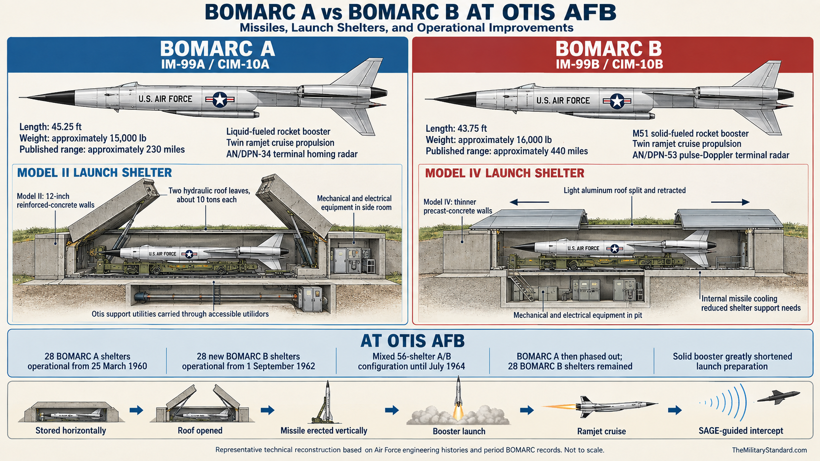
The launch complex developed in two principal shelter groups. The first contained 28 A-model shelters and the second added 28 B-model shelters. From late 1962 until July 1964, the 26th operated a mixed installation with 56 launcher systems. After the A system was removed from service, the B group of 28 shelters defined the active plant. Environmental documents later used an approximate figure of 56 former launcher systems when summarizing the site's historical maximum, which is consistent with this period of overlapping A and B capability.Launcher shelters were above-ground structures rather than underground silos. The missile rested horizontally within its shelter and was raised to vertical for launch. A shelter protected the airframe, launcher, connections, and sensitive components from Cape Cod weather while allowing rapid opening and elevation. The A shelters required substantial environmental control and specialized support. The B shelters, often described as coffin-type structures, reflected the simpler solid-booster system and were not identical to the A structures they supplemented.
The missile maintenance and support area carried functions that did not belong in each launcher. Buildings supported inspection, component work, aerospace ground equipment, warehousing, administration, crew activity, and weapons handling. Power and heating plant, fuel systems, compressed-gas equipment, fire protection, security control, communications, paved roads, drainage structures, and utility corridors linked the operating area. The launcher rows cannot be understood apart from this support plant because a combat-ready missile depended on coordinated maintenance and utilities between alert cycles.
A subsurface utilidor connected launcher areas and carried protected utilities. EPA reviews specifically identify the launcher shelters and utilidor as the major missile structures removed in 2005. Earlier records identify buildings in the 4600 series, drainage sumps, oil interceptors, leaching wells, storm drains, and underground tanks across the later CS-10 details. Not every structure can be assigned a precise missile-era function from the public documents, so this history does not attach invented labels to individual building numbers.
Security operated at several scales. Fencing and controlled entry protected the missile plant from the surrounding reservation, while restricted internal areas separated operations, weapons, propellant, maintenance, and utilities. The squadron also maintained its own safety and accident-prevention functions. Later Army security fences became part of the environmental institutional-control system, illustrating how a Cold War perimeter continued to limit exposure even after its original classified and weapons-security purpose disappeared.
The BOMARC A System
The first Otis weapon entered service as the IM-99A and was redesignated CIM-10A in 1962. Air Force sources describe it as a long-range antiaircraft interceptor with a liquid-fueled rocket booster and twin Marquardt ramjets. The booster carried the missile through vertical launch and acceleration until ramjet operation could sustain the flight. The missile then followed ground guidance toward an assigned intercept and used its Westinghouse AN/DPN-34 radar during the final approach.Published dimensions and performance figures differ slightly among official summaries, reflecting configuration and rounding. A 102nd Intelligence Wing history describes the A model as about 50 feet long, capable of roughly 2,275 miles per hour, and having a range of about 200 miles. The missile could carry a conventional or nuclear warhead. These family figures explain the operational concept but do not establish the exact flight profile, warhead, or readiness state of every Otis missile on a given date.
Liquid-booster support imposed a heavy maintenance and safety burden. Environmental histories associate the installation with Jet Fuel-4, Aerozine-50, red fuming nitric acid, hydrazine, cleaning solvents, diesel fuel, and No. 2 fuel oil. Some of these materials belong to missile or ground-support processes and others to power, heating, or later UTES work. They should not be collapsed into a single vague category of rocket fuel, because their properties, handling systems, and environmental pathways were different.
The A model also relied extensively on vacuum-tube electronics. Maintaining stable readiness required inspection, warm-up, component replacement, test equipment, controlled temperatures, and an available technical supply chain. A missile might occupy a shelter yet be unavailable because of maintenance or acceptance status. The squadron's real contribution to the defense network therefore depended on the number of operationally ready weapons, not merely the number of concrete shelters visible on an aerial photograph.
The BOMARC B Conversion
The B model addressed several weaknesses of the first system. Its solid-propellant booster eliminated much of the liquid-booster servicing burden, reduced preparation time, and improved safety and readiness. Solid-state electronics replaced much of the A model's vacuum-tube equipment, and the lighter configuration increased useful range. These changes did not turn the site into a maintenance-free installation, but they made a missile easier to keep ready for rapid response.The 26th began implementing the new CIM-10B in June 1962. NORAD records give 1962-09-01 as the operational date for the Otis B element. The station then held 28 A and 28 B shelters in operation from late 1962 until July 1964. This mixed period is central to interpreting maps and photographs: a 56-position maximum does not mean 56 identical missiles, 56 identical shelters, or a constant 56-missile alert throughout the entire 1960-1972 history.
The A system was phased out in July 1964, leaving 28 B shelters. Retiring the older element reduced the physical plant and hazardous servicing burden while preserving the long-range missile mission. The continued B force later appeared in command inventory summaries as one of seven 28-missile squadrons. The 26th remained in the nationwide BOMARC force after the all-A sites at Suffolk County and Dow closed in December 1964.
The conversion also helps reconcile apparently conflicting site totals. Sources that call Otis a 28-launcher station are correct for the original A element, the enduring B element, or the final single-model configuration. Sources that describe 56 launchers are correct for the 1962-1964 maximum and for the total physical inventory before removal. Statements that simply say Otis had 56 BOMARC B missiles or only 28 total shelters erase the two-stage construction and are not adopted.
SAGE Command, Control, and the Engagement Sequence
BOMARC did not use an independent search radar at the launcher tract to create its own regional air picture. The Semi-Automatic Ground Environment combined reports from long-range ground radars, gap fillers, airborne early warning aircraft, radar picket ships, identification systems, and human reports. Computers at direction centers displayed and evaluated tracks so controllers could select weapons and direct an interception. Otis missile crews kept their system ready to respond when the network assigned a target.
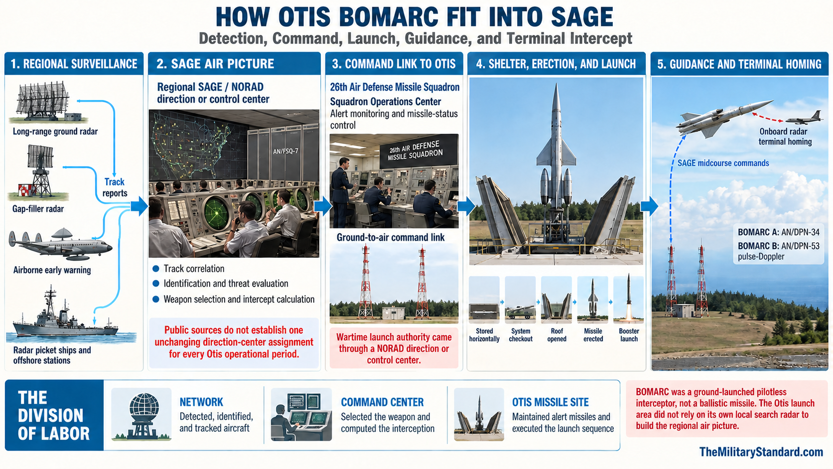
The engagement sequence began before any shelter opened. Surveillance detected a possible hostile aircraft, identification procedures evaluated the track, and commanders decided whether and how to engage it. A SAGE or NORAD control center supplied commands for launch and midcourse guidance. Once the missile approached its target, the onboard radar supported terminal homing. This division of labor explains why communications and computer connectivity were as essential to the site as shelters, missiles, and propellant.
The Boston Air Defense Sector initially owned the squadron, but public sources are inconsistent about the exact direction center that would have controlled every Otis engagement in every period. Some later accounts associate the missiles with Hancock Field's SAGE complex, while local summaries speak more generally of the sector or regional network. Command boundaries and software assignments changed over the site's life, and adjacent SAGE divisions could exercise control under the final mission statement. The safe conclusion is that Otis was integrated into the regional SAGE and NORAD network, not tied permanently to one unchanging building for all 12 years.
The system was designed for wartime use under centralized authority. A 1972 squadron booklet stated that a NORAD direction center or control center could launch the missiles only in war. Peacetime work therefore centered on readiness, training, testing, communications checks, maintenance, inspections, and evaluation rather than routine firing from Cape Cod. Live launches occurred at the Eglin range, where missiles, target drones, safety areas, instrumentation, and recovery procedures could be controlled.
Training, Evaluation, and Operational Readiness
The initial Eglin training deployment transformed a newly assembled unit into a technical operating organization. Personnel learned the missile, launcher, guidance, power, weapons, and safety systems before returning to Otis. The three-month program also created working relationships among operators, maintenance specialists, supply personnel, engineers, and contractor representatives. Winter conditions on Cape Cod then tested whether those skills could be transferred to the actual tactical plant under less favorable construction and weather conditions.The 26th became the first tactical BOMARC squadron to launch during evaluation exercises at Eglin Auxiliary Field No. 9. In March and April 1961, two launches reportedly scored direct hits against a Navy Regulus II missile target and a QF-80 jet drone. The March launch was judged the most successful BOMARC attempt to that date. These events demonstrated that an operational unit could deploy personnel into the test-range system and execute the complete maintenance, checkout, launch, guidance, and assessment sequence.
Combat Evaluation Launches continued to test mature units. NORAD history records a 26th ADMS launch at Eglin on 1965-06-19 as part of the program that drew missiles from the operational inventory for live evaluation. Such launches were not proof that the Cape Cod shelters routinely fired weapons, nor were they exercises over populated New England. They were controlled range events that linked the unit's day-to-day alert work to measurable weapon performance.
Readiness was continuous and labor intensive. Operations monitored status, maintenance corrected faults, weapons personnel controlled explosive components, supply tracked scarce spares, and engineers maintained independent utilities. Training rehearsed technical and command procedures without an actual wartime launch. Inspections and evaluations measured whether the unit could respond within prescribed time, maintain communications, protect restricted areas, and recover from equipment or power problems.
The squadron earned two Air Force Outstanding Unit Awards. The first recognized service from 1967-01-01 through 1968-06-30, and the second covered 1970-01-01 through 1971-06-30. These awards came late in the program, when aging equipment, changing command relationships, and declining strategic priority could have eroded performance. They indicate that the 26th maintained a high standard of mission accomplishment near the end of BOMARC service.
Warhead Capability and Evidence Limits
Official Air Force histories describe BOMARC as capable of carrying either a conventional or nuclear warhead, and a Tinker Air Force Base history gives a nuclear yield range of approximately 7 to 10 kilotons for the weapon family. The 102nd Intelligence Wing account likewise says both A and B models could carry either type. Nuclear capability made sense for attacking a formation of high-speed bombers at distance, where a large lethal radius reduced dependence on a direct hit.Public Otis records do not provide a complete day-by-day warhead custody history. The unit organization included a weapons section responsible for loading, unloading, storing, and handling warheads and other explosive devices, and its safety program explicitly included nuclear explosives. Those facts establish a nuclear-capable mission and nuclear-related responsibilities. They do not prove that every missile was nuclear armed at every alert posture, disclose serial numbers, or identify every storage and maintenance movement.
The environmental program conducted radiological and explosive investigations before major source-area cleanup. The 1999 Record of Decision says supplemental asbestos sampling, radiological surveys, and explosives testing occurred in 1998, and no explosive constituents were found above reporting limits in subsurface soil samples. This evidence concerns environmental conditions at sampled locations and does not prove the absence of a former nuclear mission.
Safety, Fire Protection, and Daily Work
The missile installation maintained its own electricity, heat, fire protection, transportation, and supply capability so that a failure elsewhere on the reservation would not immediately disable the weapon. Civil engineers maintained power and utility systems across the site, while safety personnel supervised missile, nuclear-explosives, and ground-accident prevention programs. Firefighters had to understand propellant, electrical, structural, fuel, and explosives hazards that differed from ordinary airfield emergencies.Daily work was dominated by prevention rather than spectacle. Crews inspected missiles and launchers, exercised equipment, verified communications, replaced components, maintained controlled environments, checked emergency systems, protected restricted material, and recorded status. Supply personnel managed items that could not be replaced through an ordinary base warehouse. Operations personnel combined these reports into an alert picture and ensured that the site could accept a valid command without unsafe or unauthorized action.
Cape Cod weather added practical difficulty. Salt air, humidity, winter freezing, storms, and temperature changes challenged structures, electrical connections, roads, doors, seals, and environmental-control equipment. The A model was especially sensitive because of its liquid systems and electronics, but the B plant also required protection. A hardened-looking shelter was not a passive bunker; it was part of an active technical environment whose reliability depended on constant human attention.
The squadron community was connected to Otis AFB for services and family life. Airmen and officers used the parent base for housing, medical care, exchange and commissary services, recreation, personnel administration, and broader logistics even though their duty site was separated from the flight line. Contractors and technical representatives also supported the weapon system. Public sources do not provide a complete social history, but the operating plant necessarily involved commuters, shift work, families, schools, local businesses, and emergency relationships across the Upper Cape.
Declining Requirement and Final Operations
BOMARC entered service as the strategic threat was changing. Intercontinental ballistic missiles reduced the relative importance of massed bomber attack, while improved interceptors, warning systems, and missiles competed for money. The Air Force sharply reduced the planned force before Otis completed its first alert. All-A sites at Suffolk County and Dow closed in 1964, but mixed A/B installations such as Otis retained the improved B model and continued to guard likely coastal approaches.The 26th's later awards show that reduced strategic prominence did not mean an immediate collapse of readiness. The unit continued alert, training, maintenance, and evaluation under the 35th and 21st Air Divisions. Aging hardware and shrinking support infrastructure nevertheless made continued operation more costly. The weapon's mission narrowed as the nation emphasized ballistic-missile warning, nuclear deterrence, and a smaller fighter-based continental defense.
The squadron became nonoperational on 1972-04-01 and inactivated on 1972-04-30. The first date marks the end of alert contribution; the second marks the formal organizational action. Environmental histories usually state that the Air Force operated or maintained the site through 1973 and then abandoned or transferred it, a year after the installation closed.
Missiles, warheads, controlled equipment, and specialized components were removed through military channels. Some BOMARC airframes elsewhere became high-speed target drones, but the public Otis record does not establish the final disposition of every assigned missile. Likewise, the exact date on which the last classified item, propellant system, or Air Force caretaker left is not publicly established. These gaps do not undermine the documented alert closure, but they limit claims about the final weeks of physical deactivation.
Transfer to the Army National Guard and UTES
The Army National Guard began limited use of vacant BOMARC buildings in 1978 and incorporated the site into Camp Edwards. UTES supported equipment maintenance and storage for Army training. Late 1990s records describe about 25 personnel maintaining 300 to 350 armored and wheeled vehicles. The mission required oils, hydraulic fluids, battery electrolyte, cleaners, paints, paint removers, vehicle washing, storage, parts, and shop work, introducing new activities into a landscape already affected by missile-era materials.Reuse preserved practical value while changing the meaning of the property. Large paved areas, secure fencing, utilities, workshops, and separated structures could support heavy equipment without new land acquisition. Missile launch rows no longer served an alert force, but the tract remained an active logistics node for a regional Army training installation. This continuity helps explain why the former site was controlled and inaccessible even after the Air Force mission ended.
The Army use also complicates environmental attribution. Air Force missile operations used solvents, fuels, drains, tanks, and specialized chemicals, while UTES used vehicle-maintenance products and continued some drainage and storage functions. EPA records describe both BOMARC and UTES as principal source-area contributors and also recognize other possible sources along the groundwater pathway. Responsible historical interpretation must avoid assigning every contaminant solely to one service or one year when the technical record supports multiple periods and pathways.
Massachusetts planning in the 2020s proposed a new Camp Edwards Readiness Center on a vacant parcel adjoining UTES and historically associated with the BOMARC property. State documents describe the earlier firing-range use, the 1960-1973 missile phase, removal of the buildings and surface utility corridor, and reuse for UTES. The state capital program later listed a substantially expanded construction project with work extending into the 2026-2027 period. This is a current Army project within the reused landscape, not a revival of the Air Force missile installation.
Environmental Discovery and Investigation
The former missile and maintenance tract became Area of Concern CS-10, with Fuel Spill 24 treated as one detail within the larger source investigation. In 1985 the removal of a 25,000-gallon underground heating-oil tank near Building 4606 released fewer than 500 gallons of No. 2 fuel oil. Contaminated soil was excavated to the extent then practical and replaced with clean sand. Monitoring wells installed in 1985 and 1986 detected groundwater contamination, prompting broader records searches, site inspections, and remedial investigations.Investigations identified volatile organic compounds, petroleum-related compounds, semivolatile compounds, pesticides, PCBs, and inorganic contaminants in various soils, sediments, drains, and groundwater. Missile-era cleaning had used methylene chloride, 1,1,1-trichloroethane, trichloroethene, tetrachloroethene, and Freon. Later maintenance used additional oils, fluids, cleaners, and coatings. Floor drains connected to leaching wells, sumps, oil interceptors, and storm drains created pathways by which releases could move from buildings into soil and the underlying unconfined sand-and-gravel aquifer.
The remedial investigation divided the source area into Details A through I. Each represented a different location or release mechanism, including maintenance areas, tanks, drainage ditches, an outfall impoundment, waste-oil disposal, and contaminated soil near buildings. FS-24 became Detail G rather than a wholly separate installation. Seven details eventually met criteria for unlimited use and unrestricted exposure, while Details C and F continued to require review and access controls.
Groundwater investigation showed that the source problem extended well beyond the fenced tract. The CS-10 plume contained trichloroethene and tetrachloroethene above federal drinking-water standards and migrated through the aquifer toward Falmouth and Mashpee. Later work also added 1,4-dioxane as a contaminant of concern in part of the plume. Plume boundaries, estimated volumes, and treatment designs changed as new wells revealed contamination farther, deeper, or in different lobes than earlier models predicted.
Source Control and Structure Removal
The 1999 Record of Decision selected a combination of excavation, disposal, asphalt batching where appropriate, soil-vapor extraction, environmental monitoring, and access controls. Earlier and concurrent work cleaned oil interceptors, removed above-ground and underground tanks, and addressed drainage structures. In 1996 the wider drainage-structure program removed liquids and contaminated soil, cleaned or filled selected structures, and eliminated pathways that could continue to release contaminants.Approximately 250 cubic yards of contaminated soil were later removed from several CS-10 details and transported off site. A soil-vapor-extraction system operated at Detail C from 2002 to 2005 and removed approximately five pounds of volatile organic compounds from the vadose zone associated with a former 300-gallon Jet Fuel-4 tank. Details C and F received additional evaluation because residual petroleum and ecological concerns required clarification. Remedy decisions evolved as sampling showed where excavation was necessary and where monitoring or no further action was justified.
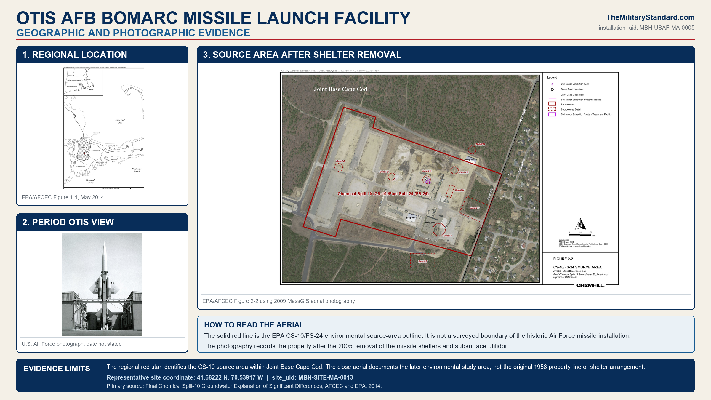
In 2005 the launcher shelters and subsurface utilidor were removed. This demolition eliminated the most recognizable physical evidence of the missile station and opened areas for continued Army use and environmental work. It also means that contemporary descriptions of surviving BOMARC shelters at Otis are outdated or refer to another station. Support buildings and Army facilities may occupy parts of the tract, but a structure-by-structure inventory requires current real-property plans and controlled-site inspection.
The demolition date is important for photographic interpretation. Images before 2005 can show the former 56-position maximum and later Army reuse among the shelters. Images after removal show the cleared and redeveloped landscape, not proof that the station never existed. Historic aerials, EPA site figures, construction plans, and period Air Force photographs must be compared by date before assigning a feature to the A element, B element, UTES, or remediation program.
Groundwater Treatment and Long-Term Remedy
The 1995 interim decision for seven reservation plumes accelerated simultaneous containment. The CS-10 Sandwich Road extraction, treatment, and reinjection system began operation on 1999-05-18, and the in-plume extraction, treatment, and infiltration system followed on 1999-06-24. A northern-lobe well began operating in January 2000 to protect Johns Pond, and a southwest and southern system began on 2000-04-27. These plants extracted contaminated water, removed contaminants with granular activated carbon, and returned treated water through reinjection wells or infiltration systems.The final groundwater remedy continued extraction and treatment, long-term monitoring, and land-use controls. Additional wells and changed pumping rates improved capture after later investigations revised the plume. A significant-differences document explained that more aggressive removal could shorten the modeled aquifer-restoration schedule to approximately 2060, while earlier modeling had projected a much later date. Such dates are planning estimates based on models and operating assumptions, not guaranteed cleanup-completion dates.
The 2023 sixth five-year review found CS-10 source-area Details C and F short-term protective under the current land-use scenario because access was controlled. It did not declare the area suitable for unlimited use and unrestricted exposure. The review recommended clearer and enforceable land-use-control language and documented annual inspection of the security controls. EPA's current site profile likewise says institutional controls remain required while contamination or remedy components remain in place.

Environmental cleanup has therefore reached different stages in different media and subareas. Known source areas have received removal or treatment, several details meet unrestricted-use criteria, two source details remain under controlled-use review, and the larger groundwater plume continues under long-term treatment and monitoring. Saying the site is either wholly contaminated or wholly cleaned would misrepresent the record. The accurate description is an active Army-use area with completed and ongoing remedies, controlled access, and continuing federal and state oversight.
Current Status, Surviving Features, and Access
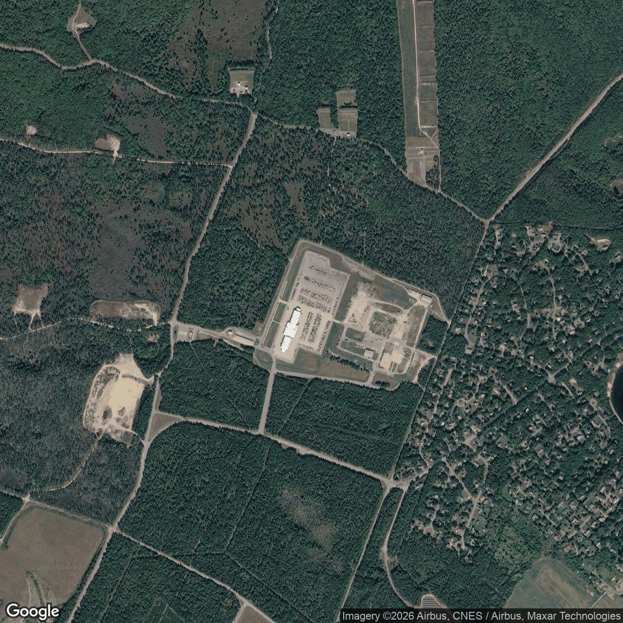
The former Air Force missile facility is closed, and the 26th Air Defense Missile Squadron no longer exists as an active unit. The land is part of the controlled Joint Base Cape Cod and Camp Edwards environment, with Massachusetts Army National Guard UTES activity and a new readiness-center project in the adjoining reused area. The missile shelters and utilidor were removed in 2005. Remaining support buildings, roads, utility traces, fences, and environmental infrastructure require current official mapping before they can be identified reliably as missile-era survivors.Public access is restricted. Active military operations, heavy vehicles, construction, security rules, and environmental controls can all affect access. Any legitimate visit, photography, or records inspection must follow Joint Base Cape Cod and Massachusetts National Guard procedures.
Chronology
- Before 1956 The future CS-10 area was wooded and portions of the landscape were used as a small rifle range within the Army reservation.
- 1946 Postwar research that led to BOMARC began within the Air Force and contractor development system.
- 1955 Production planning accelerated for a long-range pilotless interceptor integrated with continental command and radar networks.
- 1957 The first tactical BOMARC locations, including Otis, were approved and construction planning advanced.
- Late 1957 Construction began at the first operational-site group under changing launcher and funding plans.
- 1958 EPA histories date the beginning of construction at the Otis BOMARC missile site to this year.
- 1958 Fiscal-year military construction supported half-base plans at McGuire, Suffolk County, Otis, and Dow.
- 1959-01-23 The Air Force constituted the 26th Air Defense Missile Squadron.
- 1959-03-01 The 26th Air Defense Missile Squadron activated at Otis Air Force Base under the Boston Air Defense Sector.
- Summer 1959 Most authorized squadron personnel assembled at the developing Cape Cod site.
- Late summer 1959 Approximately 90 percent of authorized personnel departed for training at Eglin Auxiliary Field No. 9.
- Late 1959 Otis personnel trained on the missile and associated systems for approximately three months in Florida.
- Winter 1959-1960 The squadron returned to Otis and completed operational preparation under difficult weather and site conditions.
- 1960-03-23 Headquarters Air Force announced a major reduction of the planned BOMARC deployment.
- 1960-03-25 The 26th achieved its programmed operational date with the IM-99A BOMARC system.
- 1960 Otis and Dow raised the number of operational United States BOMARC squadrons to four.
- 1960-10-27 The Air Force approved the 26th squadron emblem and Vigilant Defender motto.
- 1961-03 The 26th conducted a tactical evaluation launch at Eglin against a Regulus II target and achieved a direct hit.
- 1961-04 A second 26th evaluation launch at Eglin scored a direct hit against a QF-80 drone target.
- 1961 The squadron continued continuous A-model alert and technical training within the SAGE network.
- 1962-06 The 26th began implementing the new BOMARC B system.
- 1962-09-01 NORAD records identify the Otis B-model element as operational.
- Late 1962 Twenty-eight A shelters and 28 B shelters were simultaneously in operation at the site.
- 1962 The designation system changed IM-99A and IM-99B to CIM-10A and CIM-10B.
- 1963 Otis continued mixed A and B alert while nationwide BOMARC plans contracted.
- 1964-07 The A-model system was phased out, leaving 28 operational B-model shelters.
- 1964-12-15 The all-A BOMARC squadrons at Suffolk County and Dow inactivated; Otis continued with the B model.
- 1965-06-19 The 26th participated in a Combat Evaluation Launch at Eglin.
- 1966-04-01 The squadron transferred from the Boston Air Defense Sector to the 35th Air Division.
- 1967-01-01 The first period later recognized by an Air Force Outstanding Unit Award began.
- 1968-06-30 The first award period ended.
- 1968 Air Defense Command was redesignated Aerospace Defense Command while the site remained operational.
- 1969-01 The 26th received its first Air Force Outstanding Unit Award.
- 1969-11-19 The squadron transferred to the 21st Air Division.
- 1970-01-01 The second period later recognized by an Air Force Outstanding Unit Award began.
- 1971-06-30 The second award period ended.
- 1972-01 The squadron received its second Air Force Outstanding Unit Award.
- 1972-04-01 The Otis BOMARC unit became nonoperational and ended its alert contribution.
- 1972-04-30 The 26th Air Defense Missile Squadron inactivated.
- 1973 Environmental histories place Air Force abandonment, final decommissioning, or transfer activity in this year.
- 1978 The Massachusetts Army National Guard began limited use of former missile buildings and established UTES activity.
- 1983 Records identify a vehicle tank-wash function operating west of the old launcher area.
- 1985 Removal of a 25,000-gallon underground tank caused the fewer-than-500-gallon FS-24 fuel spill near Building 4606.
- 1985-1986 Monitoring wells were installed and groundwater contamination was detected.
- 1989 A site investigation assessed contamination in soil, sediment, and groundwater.
- 1989-1990 An interim remedial investigation refined the nature and distribution of contamination.
- 1990-1993 Source-control actions cleaned interceptors and removed selected storage tanks.
- 1992-1993 A final remedial investigation identified nine source details requiring evaluation or cleanup.
- 1995-09-25 An interim Record of Decision established accelerated extraction and treatment for seven reservation groundwater plumes, including CS-10.
- 1996 Inactive sumps, liquids, and contaminated soil were addressed through the drainage-structure removal program.
- 1996-1997 A focused feasibility study evaluated source-control remedies for CS-10/FS-24.
- 1998 Supplemental asbestos, radiological, and explosives investigations supported remedy selection.
- 1999-05-18 The CS-10 Sandwich Road extraction, treatment, and reinjection system began operating.
- 1999-06-24 The CS-10 in-plume extraction, treatment, and infiltration system began operating.
- 1999-08-16 The source-area Record of Decision was signed for CS-10/FS-24.
- 2000-01 A northern-lobe extraction well began operating to reduce migration toward Johns Pond.
- 2000-04-27 The southwest and southern treatment system began operation.
- 2002 The Detail C soil-vapor-extraction system began operating.
- 2003 Explanations of Significant Differences revised selected soil cleanup levels and remedy details.
- 2004 Ecological work refined the evaluation of Detail F.
- 2005 Launcher shelters and the subsurface utilidor were removed from the former missile site.
- 2005-06 The Detail C soil-vapor-extraction system shut down after its treatment period.
- 2008 Additional extraction and reinjection wells were installed to improve plume capture.
- 2009-02 Optimized CS-10 groundwater pumping conditions were implemented.
- 2011 An Explanation of Significant Differences modified source-area remedy details and documented seven areas meeting criteria.
- 2017-2018 The fifth five-year review described the 52-acre source area and continued UTES use.
- 2020 A groundwater decision document added 1,4-dioxane as a contaminant of concern in part of the CS-10 plume.
- 2023-05-17 Massachusetts issued the designer-selection notice for a new Camp Edwards Readiness Center adjoining UTES on the reused BOMARC landscape.
- 2023-09-29 EPA completed the sixth five-year review for the installation-restoration program.
- 2023 The sixth review classified CS-10 Details C and F as short-term protective under current controlled land use.
- 2024-2026 State planning and procurement advanced the Camp Edwards Readiness Center project.
- 2026 UTES, construction, environmental controls, and long-term groundwater work define the former missile area's current setting.
Sources & References
- PDF 102nd Intelligence Wing, The Seagull, December 2017, The 26th Air Defense Missile Squadron Official Air National Guard history used for activation, location, Boston Air Defense Sector assignment, launcher and missile description, SAGE relationship, and 1972 inactivation.
- PDF Department of the Air Force Organizational Histories, 26 Tactical Missile Squadron Specialist compilation based on Air Force Historical Research Agency records, a 1960 unit yearbook, and a 1972 welcome booklet, used for lineage, commanders, staffing, organization, exact operational date, training, mixed A/B configuration, awards, and closure.
- PDF NORAD and CONAD Historical Summary, July-December 1959 Official command history used for initial operational squadrons, 26th ADMS activation, expected 1960 operation, force planning, and the reduction from the original national program.
- PDF NORAD and CONAD Historical Summary, July-December 1960 Official command history used for the A/B force plan, the decision to make Otis a mixed-model squadron, 28-launcher B strength, and the 1962-09-01 B-model operational date.
- PDF NORAD and CONAD Historical Summary, January-June 1965 Official command history used for the 1965-06-19 Otis Combat Evaluation Launch and the mature seven-squadron, 28-missile force structure.
- PDF North American Aerospace Defense Command, ADC and Antibomber Defense, 1946-1972, Historical Study No. 39 Official Air Defense Command study used for the strategic context, 1960 operational status at Otis and Dow, interceptor-force change, SAGE integration, and later contraction of continental air defense.
- PDF Air Defense Command Historical Study No. 14, History of Air Defense Weapons, 1946-1962 Official historical study copy used for early BOMARC planning, fiscal 1958 construction at the first four sites, changing launcher totals, construction problems, and national program development.
- WEB U.S. Air Force, Tinker History: Douglas IM-99 BOMARC Missile Official Air Force article used for BOMARC purpose, 7-to-10-kiloton nuclear capability, A-model liquid booster and AN/DPN-34 terminal radar, B-model solid booster, and changing strategic value.
- PDF Air Force Life Cycle Management Center, Winged Missiles Official Air Force monograph used for development designations, missile evolution, production context, surviving photographs, and the relationship between the interceptor and later target-drone configurations.
- PDF Air Force History and Museums Program, Leading the Way: The History of Air Force Civil Engineers, 1907-2012 Official Air Force study used for BOMARC construction planning, specialized A-model fuel and utility plant, shelter design, contractor coordination, safety, and civil-engineering requirements.
- WEB Massachusetts National Guard, Camp Edwards History Official state military history used for the wider reservation setting, Otis air-defense activity, SAGE context, 1959 BOMARC construction account, and the site's place among the limited national deployment.
- WEB Massachusetts National Guard, Joint Base Cape Cod Overview Official installation source used for current Camp Edwards identity, mission, tenants, controlled military setting, and relationship among the organizations occupying Joint Base Cape Cod.
- PDF U.S. Environmental Protection Agency and U.S. Air Force, Record of Decision for AOC CS-10 and FS-24, 1999 Official decision document used for the 38-acre AOC, site setting, operating history, nine source details, contaminants, drainage features, selected source remedy, radiological and explosives testing, and public process.
- PDF U.S. Environmental Protection Agency, First Five-Year Review, Otis Air National Guard Base and Camp Edwards Official review used for the 1958 construction start, 1960-1973 Air Force interval, 1978 UTES reuse, 1985 spill, investigations, drainage removals, and early cleanup status.
- PDF U.S. Environmental Protection Agency, Third Five-Year Review, Joint Base Cape Cod Official review used for the 2005 removal of shelters and utilidor, 56-system maximum, missile and UTES materials, soil-vapor extraction, source-area remedies, and protectiveness findings.
- PDF U.S. Environmental Protection Agency and U.S. Air Force, Fifth Five-Year Review, Joint Base Cape Cod, 2018 Official review used for the 52-acre source-area description, 2005 structure removal, current UTES use, 300-to-350 vehicle mission, completed actions, and remedy evaluation.
- PDF U.S. Environmental Protection Agency and U.S. Air Force, Sixth Five-Year Review, Joint Base Cape Cod, 2023 Official review used for the present 52-acre CS-10 source area, Details C and F, short-term protectiveness determination, access-control issue, and continuing five-year-review requirement.
- PDF U.S. Environmental Protection Agency, Final Chemical Spill-10 Groundwater Explanation of Significant Differences Official decision document used for the 38-acre AOC, 3.6-mile plume, treatment systems, contaminant history, 2005 demolition, optimization, land-use controls, and modeled restoration schedule.
- PDF U.S. Environmental Protection Agency, Explanation of Significant Differences for 1,4-Dioxane at CS-10 Official document used for addition of 1,4-dioxane as a groundwater contaminant of concern, the larger plume scale, and continued treatment and monitoring.
- WEB U.S. Environmental Protection Agency, Otis Air National Guard Base and Camp Edwards Superfund Site Profile Current official site profile used for 2023 review status, institutional controls, National Priorities List context, decision-document inventory, and continuing federal cleanup oversight.
- WEB Commonwealth of Massachusetts, Public Notice of Designer Selection, Camp Edwards Readiness Center, 2023 Official state planning document used for former firing-range and BOMARC use, removal of buildings and surface utilities, UTES relationship, and the modern readiness-center project.
- WEB Commonwealth of Massachusetts, Fiscal Year 2024 Capital Plan, Camp Edwards Readiness Center Official state budget source used for the readiness-center purpose, funding, agency, and Bourne location within the current National Guard program.
- WEB Commonwealth of Massachusetts, Construction Manager at Risk Projects Official current project listing used to verify that MIL2201 construction remains active in the 2026-2027 period and to distinguish current Army development from the former Air Force missile mission.
- WEB Massachusetts National Guard, Environmental Management Commission and Camp Edwards Access Information Official installation material used for current controlled-access conditions, environmental oversight, aquifer protection, and the active military-training setting.
- PDF Department of Defense Legacy Resource Management Program, Defend and Deter: The Legacy of the United States Cold War Missile Program Officially sponsored historic-context study used for the national BOMARC station list, Otis A and B identity, 1959-1972 unit interval, and comparison with the separate Army Nike system.
- PDF ADC Historical Data, 1946-1973, uploaded project source (17.67 MB) Air Defense Command reference checked for Otis, L-5, radar-squadron, SAGE-era, and regional-site context; its radar tables do not substitute for the separate missile-unit and environmental records.