
Clear Air Force Station, Alaska
From the giant BMEWS reflectors to phased-array warning, missile-defense discrimination and protected Arctic communications.

Longitude: -149.179917
- Station code
- BMEWS Site II; historic 474L system
- Mission
- Missile warning, missile-defense sensor support, space domain awareness and protected Arctic communications
- Original radars
- AN/FPS-50 detection; AN/FPS-120, later FPS-123 catalog labels; current AN/FPS-132 UEWR
- Separate LRDR
- S-band search, tracking and discrimination; operational acceptance December 4, 2025
- Principal local units
- 13th and 213th Space Warning Squadrons; 268th Security Forces Squadron
- Arctic communications
- Enhanced Polar System-Recapitalization gateway; 2026 program acceptance announced
- Operating history
- BMEWS service from 1961; Space Force station name June 15, 2021; active
- Published area
- 11,438 acres in May 2021 EIS; older records round to about 11,500
- Location
- Near Anderson, Denali Borough, Alaska; west of Parks Highway beside the Nenana River valley
History
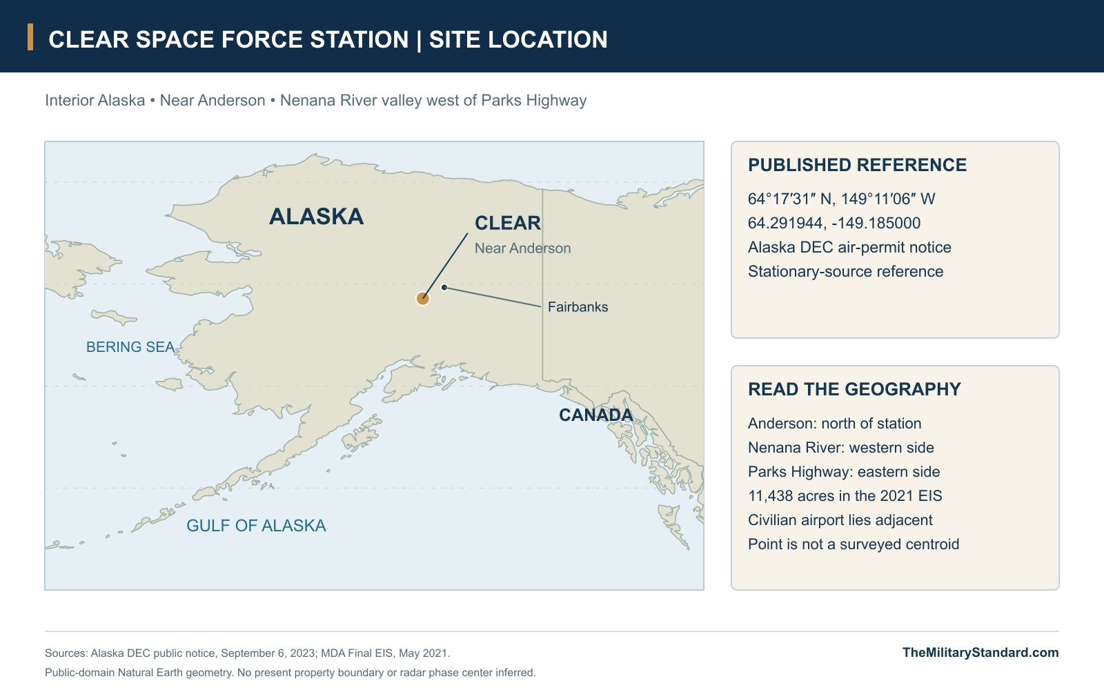
Clear Space Force Station occupies a wooded part of the Nenana River valley near Anderson, south of Fairbanks. Its Cold War reflectors once formed one of Alaska's most conspicuous military landscapes. Their successors watch for ballistic missiles and measure objects in space, while a newer radar adds detailed threat discrimination. The station's continuity rests on this warning mission rather than on the survival of any one antenna. Clear has passed from an Air Force construction project to an active Space Force installation without becoming a missile-launch base. [9] [23] [27]
The published station reference is 64.291944° N, 149.185000° W, converted from Alaska's air-permit notice. It identifies the stationary source and is useful for locating Clear, but it is not a surveyed property centroid, a radar phase center or a visitor entrance. The 2021 environmental statement describes 11,438 acres; restoration records round the installation to approximately 11,500 acres, with about 3,800 developed. These modern descriptions also differ from the much larger 34,642-acre historical withdrawal discussed in the engineering record. [1] [9] [11] [12]
Choosing and Building BMEWS Site II
Clear's military antecedents preceded the missile-warning station. The engineering history records a 1947 land withdrawal, a short-lived air-control-and-warning radar in 1948 and subsequent use as Clear Air Force Auxiliary Field and an Alaskan Air Command gunnery range. The land returned to the Department of the Interior in 1949, and a 1956 fire destroyed the early radar structures. Those episodes explain why descriptions sometimes assign an earlier military origin to Clear, but they do not make the later BMEWS complex a wartime operating radar station. [1] [34]
The Air Force selected Clear for BMEWS Site II in January 1958 and reacquired the site that year. Access, relatively favorable ground, open radar horizons and limited electronic interference made it preferable to other candidates. Construction began in 1958, combining a temporary work camp with permanent accommodation and an exceptionally demanding technical complex. Army Corps of Engineers construction management connected national radar contractors with local builders. Labor disputes and the May 4, 1960 fire in Transmitter Building 102 disrupted the schedule, illustrating how a strategic deadline depended on ordinary construction trades and resilient logistics. [1] [34]
Opening was a sequence rather than a single ceremony. The engineering history places completion of major facilities in March 1961, initial operating capability on September 30 and full operational status on December 31. A later Space Force account summarizes full operation as November 1961. The difference remains visible because construction acceptance, crew assumption and operational readiness could be reported differently. Clear is therefore best described as entering BMEWS service in 1961, with the September and December milestones explicitly attributed to the detailed construction history. [1] [10]
The Historic Station Layout
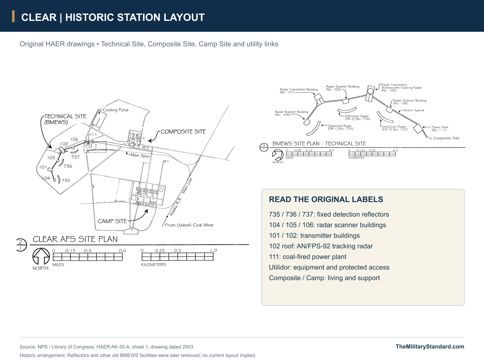
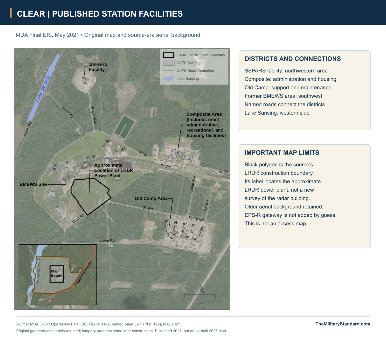
Clear was organized around three connected districts. The Technical Site contained the detection reflectors, scanner and transmitter buildings, tracking radar and generating plant. The Composite Site supplied administration, dormitories, dining, recreation and vehicle support. The original Camp Site retained construction-era accommodation, warehouses and engineering functions. Their separation concentrated high-power electronics in a controlled industrial area while keeping daily living and maintenance within a practical travel distance. Roads, rail delivery and protected passageways made these districts parts of one operating station. [2] [6] [11]
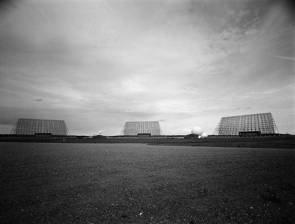
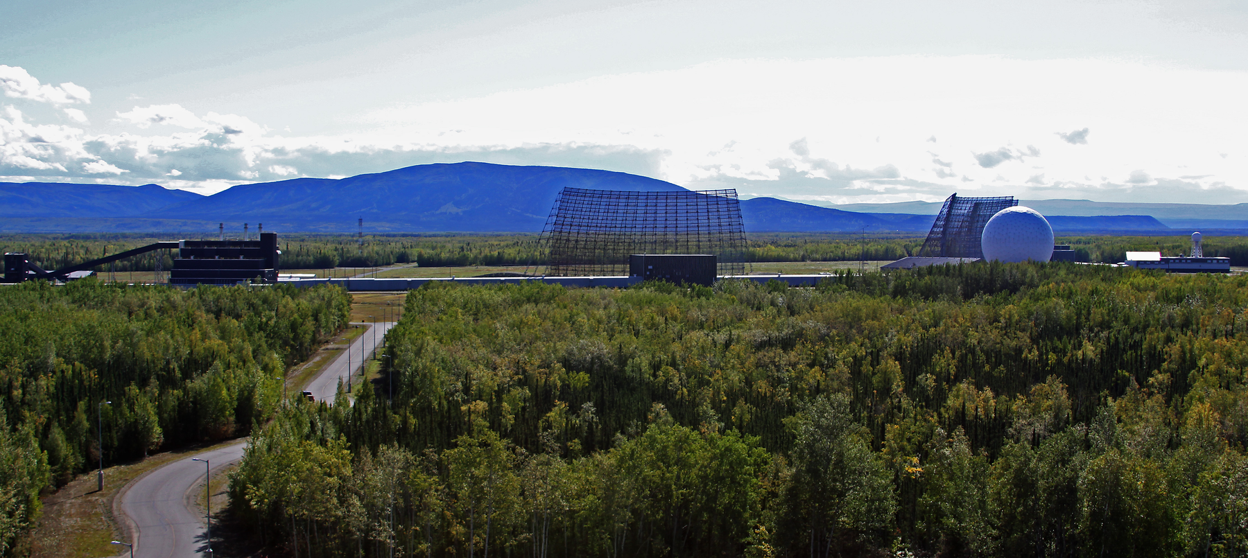
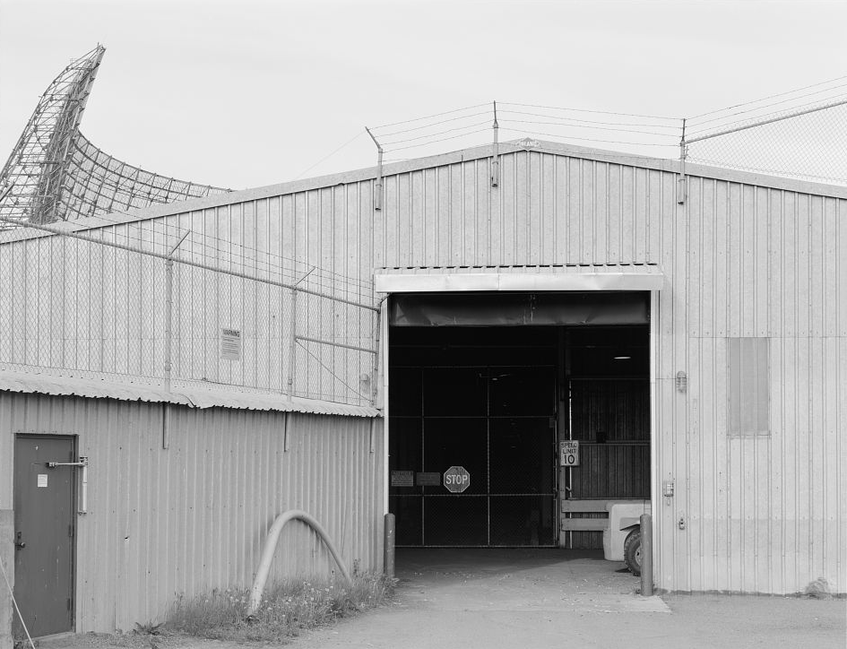
The measured plan identifies three fixed detection antennas, Structures 735, 736 and 737, facing Scanner Buildings 104, 105 and 106. Transmitter Buildings 101 and 102 stood along the connecting utilidor. Building 102 carried the later tracking radar and its protective dome; the coal plant, Building 111, occupied a separate utility enclosure near the railway spur and cooling pond. The source drawing preserves this arrangement directly. It is a record of the historic technical site, whose removed antennas must not be mistaken for surviving modern equipment. [2] [5] [6] [17]
How the Original Radars Worked
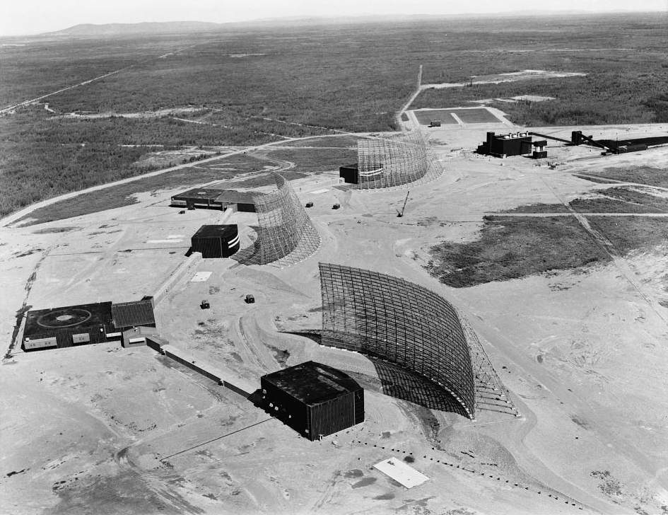
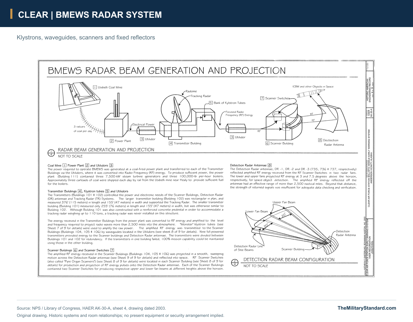
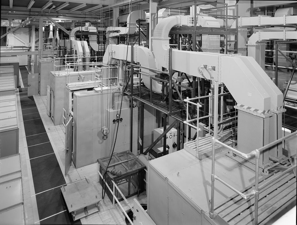
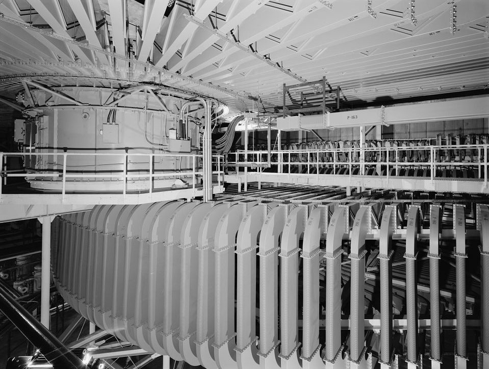
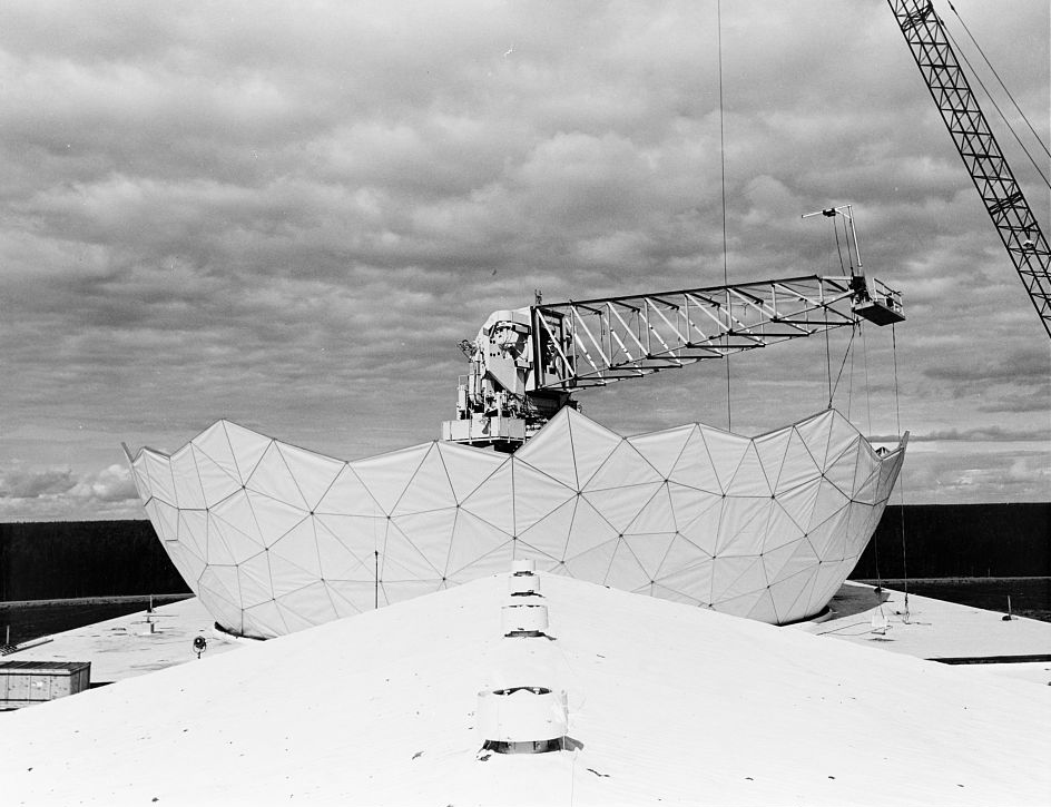
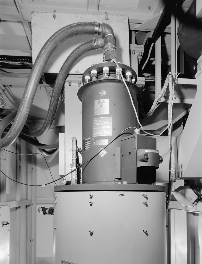
The AN/FPS-50 detection system used enormous stationary curved reflectors rather than rotating search dishes. Energy produced in the transmitter buildings passed through waveguides to the scanner buildings, where mechanical switching distributed it among feedhorns. The reflectors projected paired radar fans into the northern approaches. A missile passing through those fans produced measurements that could be converted into warning information. The system's imposing visible surfaces were only the final part of a chain that also required vacuum-tube amplifiers, precise timing, cooling, processing and reliable communications. [3] [7] [8]
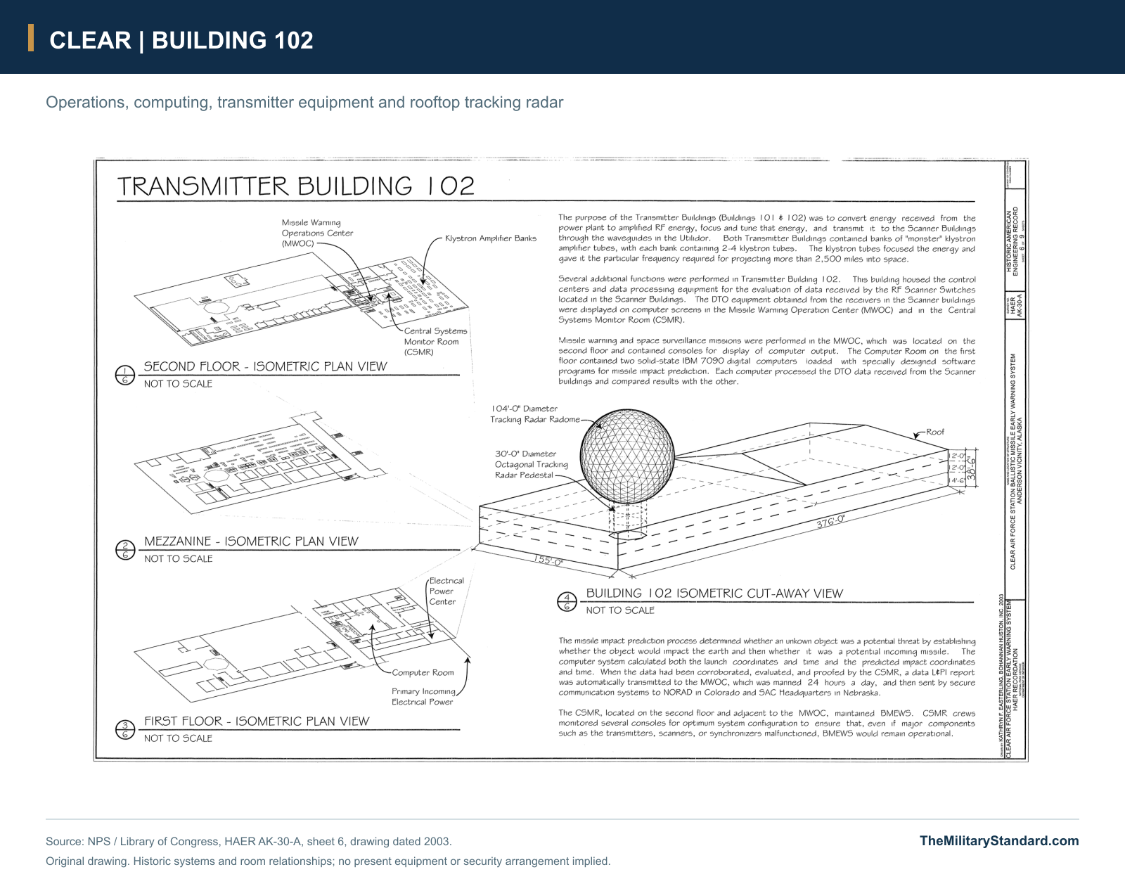
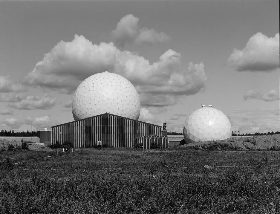
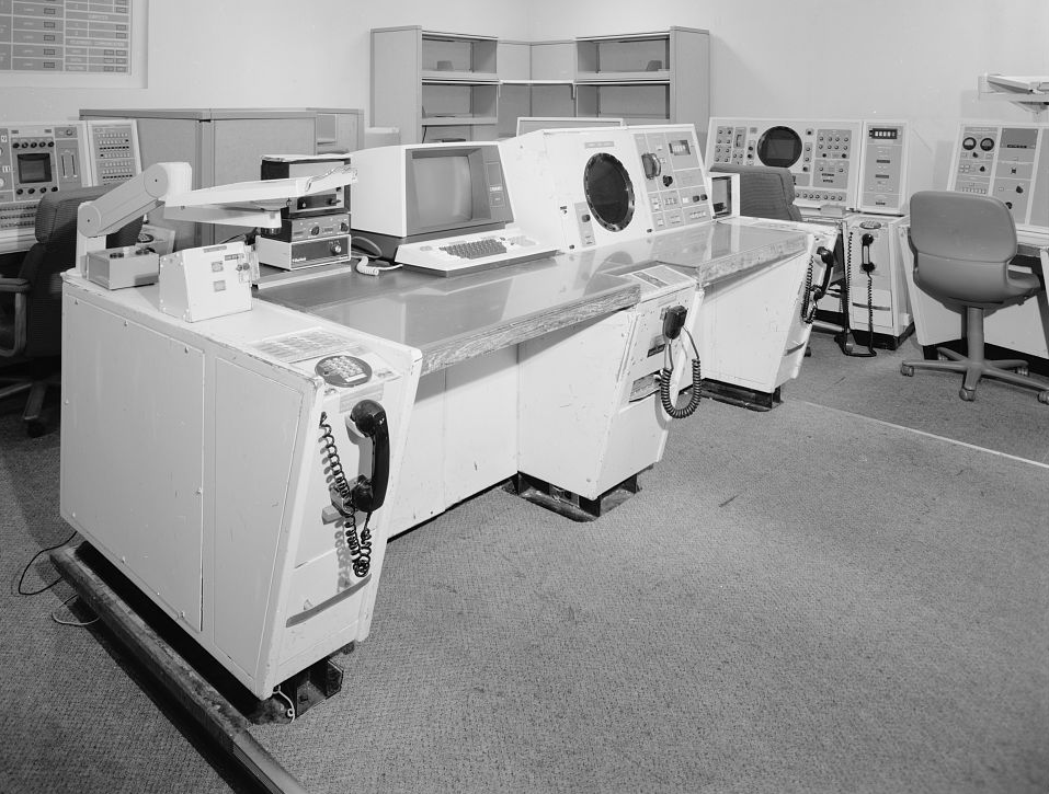
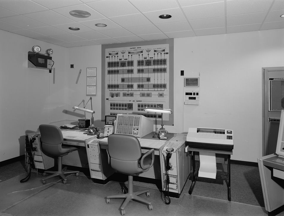
The AN/FPS-92 tracker, added in 1965-66 and reaching initial capability in June 1966, performed a different job. Its steerable antenna provided more precise observations of selected targets and contributed substantially to space tracking. Building 102 combined this rooftop radar with transmitter equipment, monitoring and operations spaces below. Missile-impact-prediction computers transformed observations into assessed trajectories for command centers. The original IBM 7090 computers eventually gave way to Control Data equipment, showing that substantial modernization could occur inside buildings whose exterior profiles changed little. [1] [4] [5]
Standing Watch During the Cold War
Clear's first operating organization was a detachment of the 71st Missile Warning Wing. The detailed engineering history identifies Detachment 2 and records its replacement by the 13th Missile Warning Squadron on January 1, 1967. The installation measured success through sustained radar availability, often described as green time, because an unexpected outage could remove warning during the very interval it was needed. Operators, communications specialists, electronics maintainers and the support workforce therefore shared the strategic mission. A functioning reflector without a trustworthy report to the command center would have been insufficient. [1] [34]
The station's connection to Cold War confrontations lay in continuous strategic warning. Its northern view supported assessment of an attack across the polar region, but the 1962 Cuban Missile Crisis also demonstrated the limits of a warning system oriented toward Soviet territory. Missile threats arriving from other directions required additional sensors. Clear subsequently worked within a broader architecture as satellite warning and coastal radars expanded coverage. Its history should consequently distinguish sustained homeland-defense duty from participation in a named overseas combat campaign. [1] [34]
Reliability had to survive both Alaska's environment and deliberate interference. The engineering record describes only a brief interruption during the March 27, 1964 earthquake and later tests against electronic countermeasures. B-52 aircraft participated in Snotime 74-5, and an EB-57 supported Fencing Indian 77-5. Experiments with the University of Alaska also examined auroral effects on radar propagation. These events made the station an operating laboratory for maintaining warning in adverse conditions, rather than a passive collection of large antennas. [1]
Command changes gradually aligned missile warning with the growing space mission. The engineering history records BMEWS passing through Strategic Air Command before moving to the 1st Space Wing in May 1983 under Air Force Space Command. The 21st Space Wing inherited that organization's responsibilities in May 1992, and Clear's unit became known as the 13th Space Warning Squadron. Through these changes, the local task remained continuous observation and reporting. The new organizational names reflected the increasing connection between ballistic trajectories, orbiting objects and a national space-surveillance network. [1] [16] [40]
Role in the Wider Military Network
Clear was BMEWS Site II, alongside Site I at Thule in Greenland, now Pituffik Space Base, and Site III at RAF Fylingdales in Britain. Each occupied a different position in the warning geometry and reported to the wider command system. The historic Clear network used redundant rearward communications, including an inland route along the Alaska-Canada corridor and another path involving Alaska microwave links, the Boswell Bay-Annette Island troposcatter connection and onward cable and telephone service. These links carried the value of the radar beyond its local horizon. [1] [34]
Today the relationship includes missile warning, missile defense and space domain awareness. Clear's UEWR and LRDR are separate sensors, and the 13th Space Warning Squadron also supports Cobra Dane at Eareckson Air Station on Shemya. A 2014 command account documents the 2013 transfer that brought Cobra Dane's complete mission and management back under Air Force Space Command. That organizational relationship did not move its antenna to Clear. The distinction matters when interpreting unit descriptions, equipment lists and photographs from the two Alaska installations. [9] [21] [27]
From Mechanical BMEWS to Phased Arrays
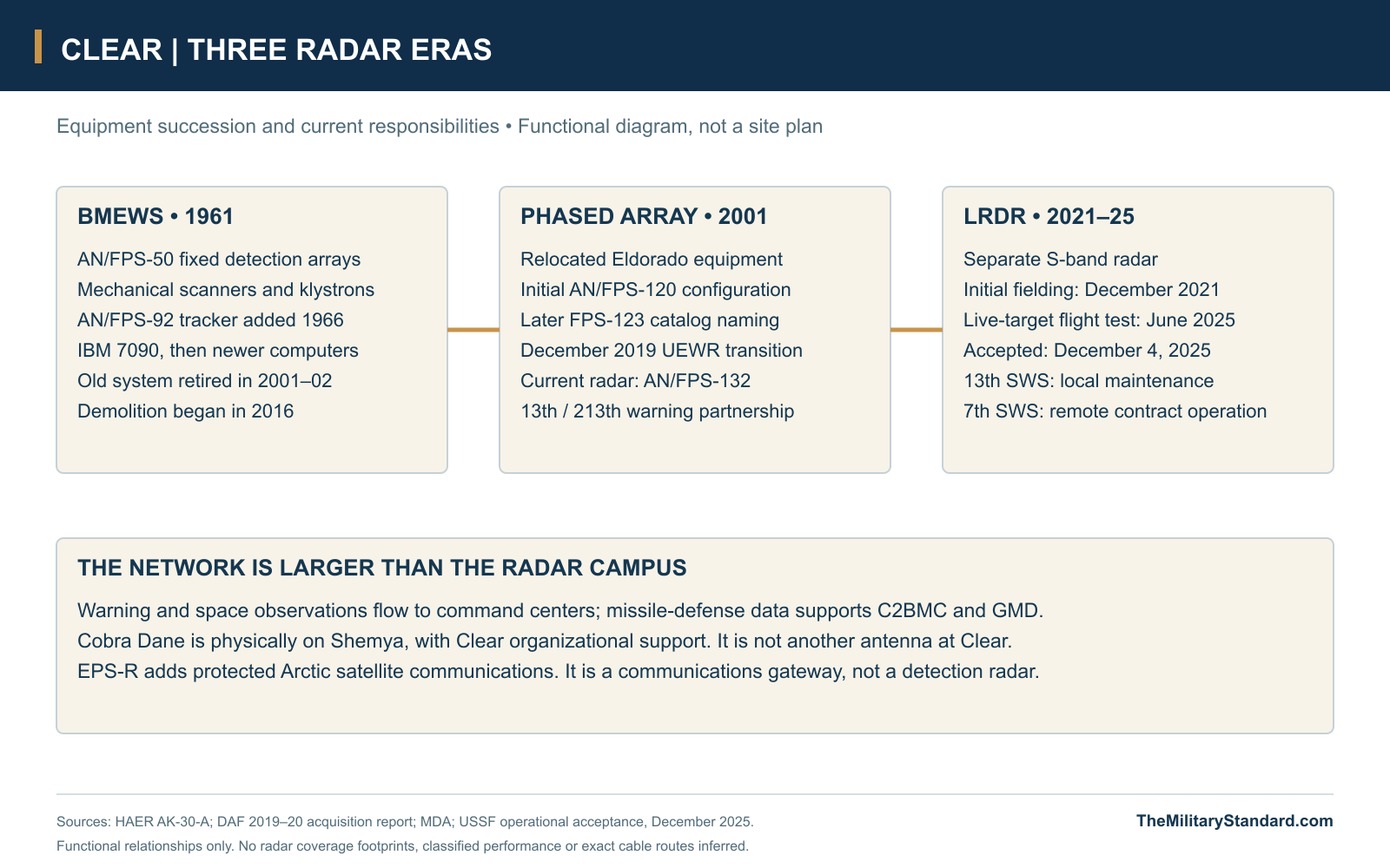
The Cold War's end did not eliminate the need for warning or space tracking, but it made the old system's maintenance burden harder to justify. Clear received equipment salvaged and reconfigured from the closed Eldorado, Texas, PAVE PAWS site in a new phased-array facility. The replacement entered operation in 2001. Institutional accounts describe the old system's decommissioning in 2002, whereas the engineering history identifies a January 2001 tracker shutdown. Replacement capability, cessation of individual equipment and administrative decommissioning are therefore separate milestones. [1] [16] [37]
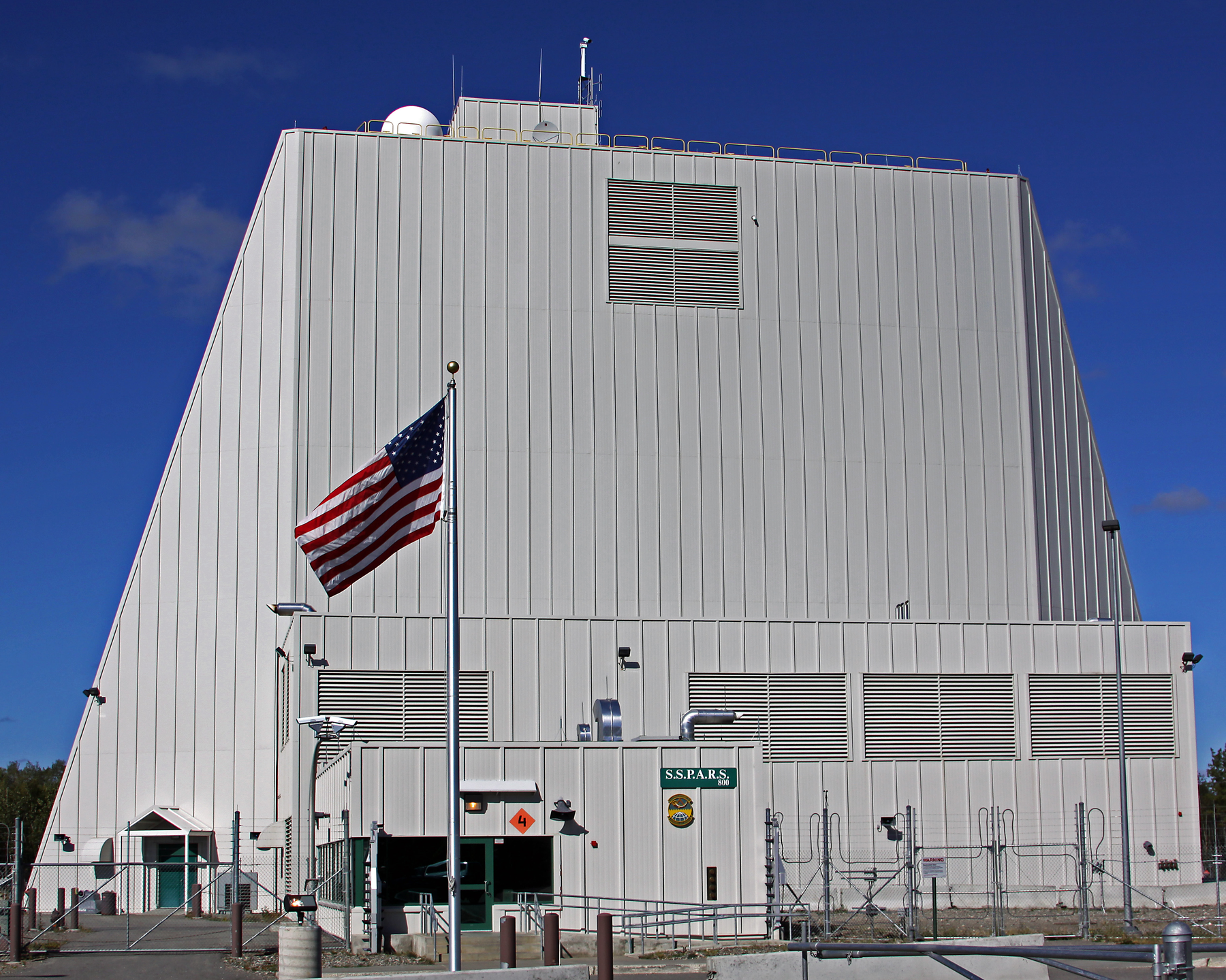
The solid-state radar replaced much of the mechanical switching and centralized high-power tube machinery with electronically steered arrays. Its tall technical building became Clear's new landmark. Contemporary configuration evidence identifies the initial Clear system as AN/FPS-120, while later official Air Force catalogs used AN/FPS-123. A public engineering-change date resolving that naming difference has not been established. The current configuration is the AN/FPS-132 Upgraded Early Warning Radar; the Department of the Air Force places Clear's UEWR transition in December 2019. [16] [22] [36] [37] [39]
Guard Crews and Installation Security
The Alaska Air National Guard became central to Clear's daily operations during the phased-array era. The 213th Space Warning Squadron stood up in 2006 under the 168th organization at Eielson. A joint account by active-duty and Guard leaders describes the 213th as the principal force provider for radar operations, security and several support responsibilities. Personnel worked through the appropriate state and federal duty statuses to sustain a national mission. The arrangement retained active-duty oversight while drawing on a Guard workforce with longer local continuity. [18] [19]
Security became a distinct squadron function when the 268th Security Forces Squadron activated on October 4, 2017. Its defenders had previously belonged to the 213th. The new organization protected the surveillance and missile-tracking facilities while providing law enforcement, pass and registration, armory support and readiness training. This was an organizational separation within the existing installation, not the creation of another radar site. Together the warning crews, defenders, civilian employees and contractors supplied the people needed to keep highly specialized equipment available around the clock. [20]
Power, Maintenance and Daily Life
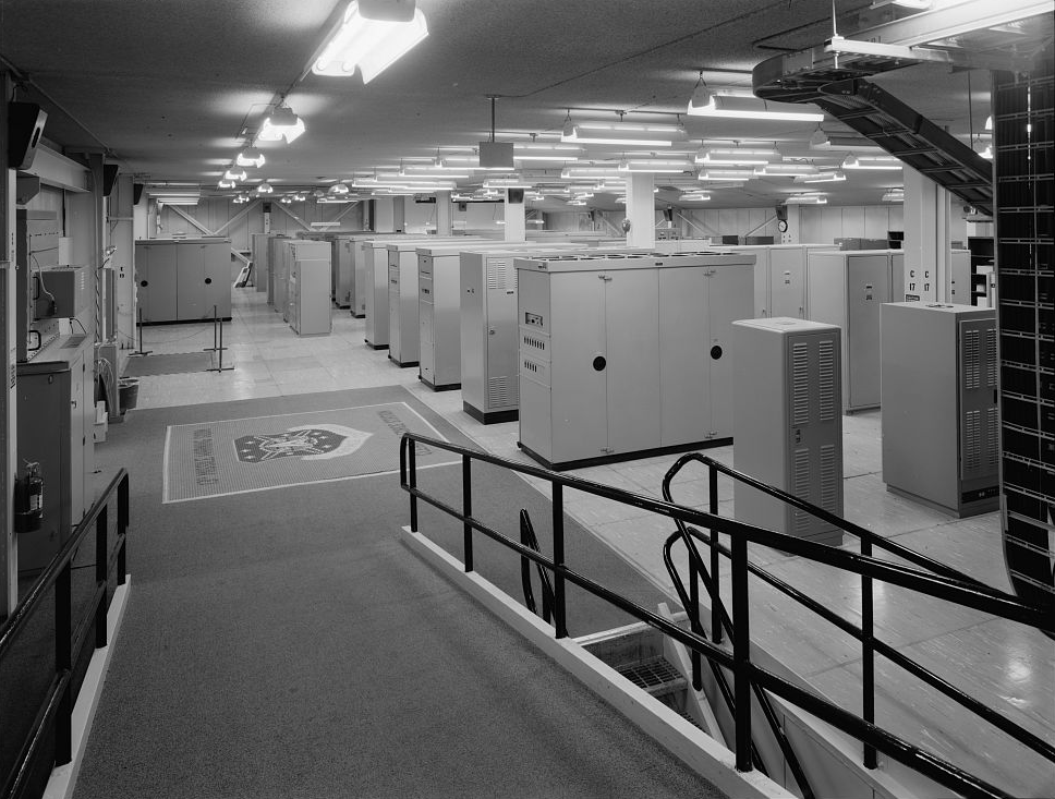
Clear's remote character shaped its support system even though rail and highway access distinguished it from Alaska's coastal stations. Dormitories, dining, recreation, workshops, vehicle maintenance and protected connections made continuous duty possible through long winters. The utilidors carried equipment services as well as people, joining transmitter and scanner buildings without requiring every maintenance movement to cross exposed ground. Original photographs show the scale of the work behind the radar face: equipment cabinets, monitoring consoles, amplifier vaults and the branching waveguides of the pipe-organ scanners. [2] [5] [6] [7] [8] [33]
Electricity and heat once depended on the station's coal-fired generating plant, supplied through a railway spur from the Healy mining area. Lower radar power demand and the aging plant eventually prompted a search for alternatives. GAO's 2014 review found that the Air Force considered leasing and other options before selecting closure, though some cost components were incompletely developed. The station connected to commercial electricity and installed new heating and backup capability. January 2016 decommissioning of the coal plant changed its infrastructure while the warning mission continued. [13] [14] [15]
Installation support now reaches Clear through Space Base Delta 2 at Buckley. That connection became especially tangible during the 2022 Clear Fire, when the delta sent emergency-management personnel for four weeks of support. It also extends to sustaining and modernizing buildings and utilities, as documented during an August 2025 leadership visit. These activities show another dimension of readiness: protecting a remote station and maintaining its infrastructure through regional emergencies. Announced future projects remain distinct from facilities demonstrated to have been completed. [41] [42]

Long Range Discrimination Radar
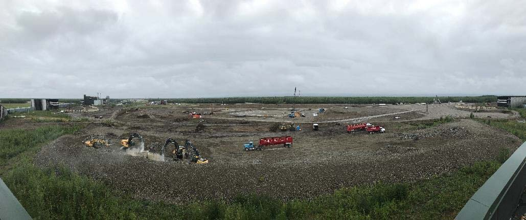
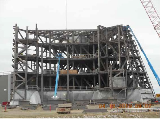
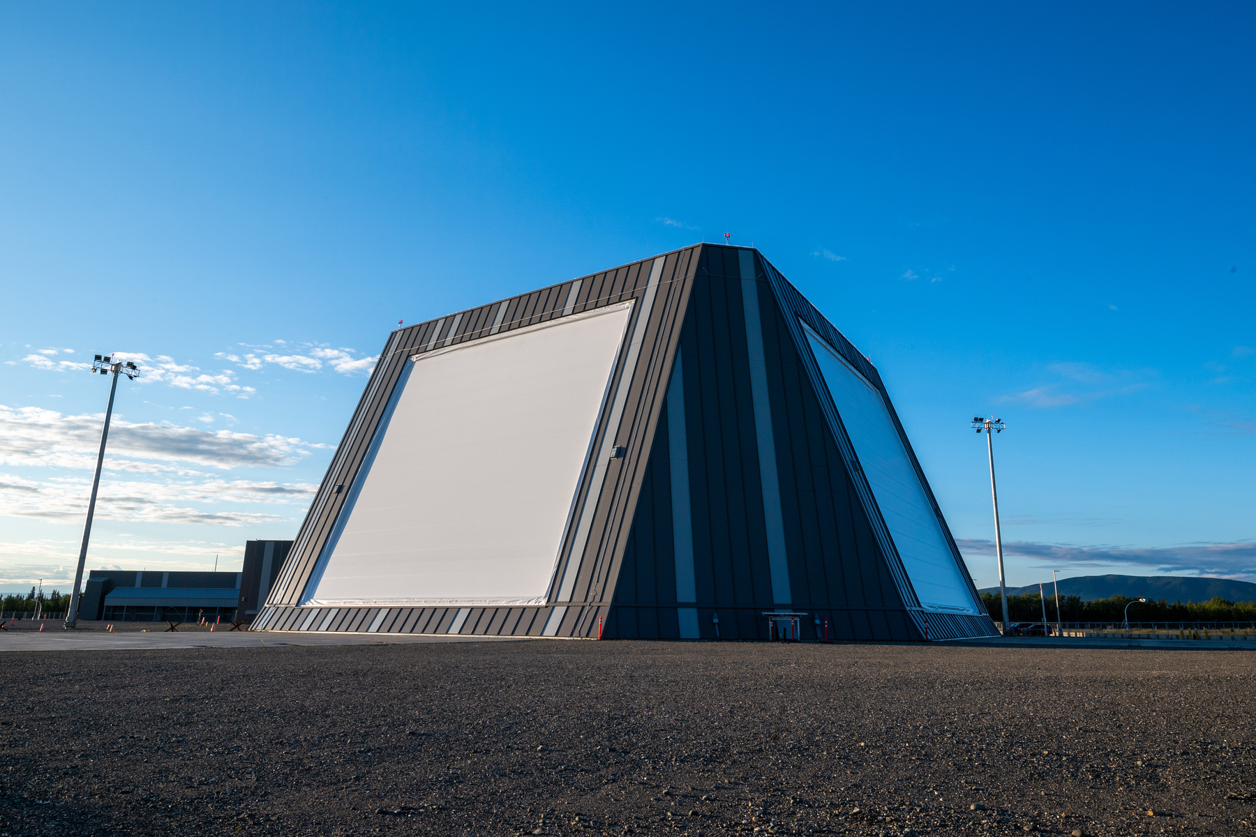
The Long Range Discrimination Radar introduced another substantial building and a different emphasis to Clear. The Missile Defense Agency selected the station in 2016 after environmental review. Its S-band arrays are designed to search, track and discriminate, helping separate threatening objects from debris and decoys so the defense system can use interceptors more effectively. Construction required an equipment shelter, mission-control facilities and supporting utilities. The released construction photographs document that growth without suggesting that the new radar was simply a renamed UEWR. [9] [23] [32]
Initial fielding on December 6, 2021 marked completion of a major development stage, followed by testing and integration. On June 23, 2025, FTX-26a presented an air-launched ICBM-representative target over the northern Pacific. Both LRDR and Clear's UEWR tracked it, and data passed through C2BMC to support a simulated Ground-Based Midcourse Defense engagement. The exercise demonstrated a sensor and command-network connection. It did not involve a combat attack or establish that an interceptor had been fired during that test. [24] [25]
Combat Forces Command accepted LRDR for operations on December 4, 2025, as announced four days later. The official account assigns maintenance to the 13th Space Warning Squadron at Clear and daily remote operation to 7th Space Warning Squadron contract operators at Beale and Cheyenne Mountain through the C2BMC sensor manager. That division separates the radar's physical home from its operating locations. The acceptance is a later milestone than the 2021 fielding ceremony or the contractor's delivery, and neither earlier event should substitute for it. [26]

Space Force and Protected Arctic Communications
The 13th Space Warning Squadron transferred to Space Delta 4 on July 24, 2020, and the installation was formally renamed Clear Space Force Station on June 15, 2021. The new service identity recognized a mission already extending beyond the atmosphere. Current command descriptions place the warning and tracking organization within Mission Delta 4. The Guard partnership continued through the transition, so the new station name did not mean that every Airman became a Guardian or that the Alaska Air National Guard squadrons ceased to exist. [10] [18] [27]
Clear also gained a protected-communications role through the Enhanced Polar System-Recapitalization gateway. Space Systems Command announced groundbreaking in August 2022 for terminals linking to payloads hosted through a Norwegian partnership. The purpose was to sustain protected military communications across the Arctic, where ordinary coverage can be difficult. Space Force announced EPS-R program operational acceptance in March 2026. That program milestone confirms the communications mission's progress but does not supply a separate commissioning date for every ground terminal at Clear. [28] [29]
Airspace, Neighbors and Regional Effects
LRDR operation required decisions extending beyond the fenced station. The 2021 environmental statement examined high-intensity radiated fields, restricted-airspace design, changes to air routes and effects on neighboring communities. Clear Airport is adjacent to the installation and serves civilian aviation; its runway should not be described as an operational military flying wing's airfield. Pilots, emergency responders, residents, Alaska Native organizations and public agencies participated in consultation. The practical issues included emergency access, flight detours and the future of Civil Air Patrol glider training. [9]
The environmental review led to a formal airspace process rather than an automatic enlargement of the installation's property. The FAA's November 2022 final rule amended R-2206 and established additional restricted areas associated with LRDR. Ground boundaries, beam-related restrictions and the much broader area considered for environmental effects are different kinds of geography. Historical maps are useful for understanding those relationships, but pilots need current charts and notices for actual operations. A source-era airspace diagram cannot establish present access permission. [9] [38]
Demolition, Environmental Work and Continuing Use
The disappearance of the old BMEWS reflectors was a visible change, not Clear's closure. Demolition began in October 2016 as the installation prepared for new construction. Environmental records subsequently documented PCB- and lead-containing paint, affected soil and drainage features, and contaminated concrete associated with Buildings 101 and 102. A removal action addressed portions of those foundations in 2021. Alaska's former-BMEWS record remains active, so demolition and removal of major structures cannot be presented as proof that every associated contamination issue has been resolved. [17] [30]
Separate PFAS investigations address areas associated with firefighting foam and other potential releases. Alaska DEC maintains a sitewide record alongside individual contaminated-site entries, reflecting the need to investigate particular source areas rather than assign one condition to all station land. Clear remains an active federal defense installation while this work continues. Its legacy is consequently both operational and physical: a continuous national warning watch, a changing workforce and sensor network, and an industrial landscape whose older systems survive most completely in measured drawings, photographs and environmental records. [9] [27] [31]
Chronology
- 1947-49 Land withdrawal and early AC&W use precede the later BMEWS station; land returned to Interior in 1949. [1]
- January 1958 Clear selected for BMEWS Site II; Air Force reacquisition and construction followed in 1958. [1]
- 1959-60 Labor disputes and the May 4, 1960 Building 102 fire delay construction. [1]
- September 30, 1961 Initial operating capability in the detailed engineering history. [1]
- Late 1961 HAER gives December 31 for full operation; the 2021 Space Force summary instead gives November. [1] [10]
- March 27, 1964 Earthquake briefly interrupts the radar without lasting damage in the engineering account. [1]
- 1965-June 1966 AN/FPS-92 installed on Building 102 and reaches initial capability. [1] [5]
- January 1, 1967 13th Missile Warning Squadron replaces the 71st Wing detachment. [1]
- 1969-70 Tracking automation and auroral experiments improve operations. [1]
- 1974 and 1977 Snotime and Fencing Indian exercises test resistance to interference. [1]
- 1981-83 Tracker radome and computing equipment undergo major replacement. [1] [33]
- May 1983 BMEWS moves to the 1st Space Wing under Air Force Space Command. [1]
- May 1992 21st Space Wing succeeds the 1st Space Wing; Clear continues under the space-warning organization. [16] [40]
- 2001-02 Phased-array operation begins in 2001; later accounts describe legacy BMEWS decommissioning in 2002. [1] [16] [37]
- 2006 213th Space Warning Squadron stands up as the Guard force provider. [18] [19]
- 2013 Complete Cobra Dane mission and management transfer to AFSPC with 13th SWS oversight; radar remains on Shemya. [21]
- January 2016 Commercial electricity replaces the coal-era supply arrangement and the coal plant is decommissioned. [9] [13] [15]
- 2016 LRDR location selected following environmental review; BMEWS reflector demolition begins October 18. [17] [23]
- October 4, 2017 268th Security Forces Squadron activates at Clear. [20]
- December 2019 Department of the Air Force reports transition to UEWR. [22]
- July 24, 2020 13th SWS transfers to Space Delta 4. [10]
- June 15, 2021 Station renamed Clear Space Force Station. [10]
- December 6, 2021 LRDR initial fielding ceremony; testing and integration continue. [24]
- August 2022 EPS-R gateway construction announced. [28]
- 2022 Clear Fire Space Base Delta 2 sends emergency-management personnel for four weeks of support. [42]
- November 7, 2022 FAA publishes Clear restricted-airspace final rule. [38]
- June 23, 2025 FTX-26a: LRDR and UEWR track an ICBM-representative target for a simulated engagement. [25]
- December 4, 2025 Combat Forces Command accepts LRDR for operations. [26]
- March 2026 Space Force announces EPS-R program operational acceptance. [29]
- November 2026 review Clear remains active; former-BMEWS and sitewide PFAS environmental records remain active. [27] [30] [31]
Related Sites
Information sources (42)
- PDFNational Park Service, HAER AK-30-A: Clear Air Force Station, BMEWS Site II
John F. Hoffecker engineering history: antecedent land use, construction, September and December 1961 milestones, technical buildings, operations, communications and 1967 squadron succession. Historical acreage and shutdown wording require comparison with later records.
- WEBLibrary of Congress, HAER AK-30-A, sheet 1: station and technical-site plans
Measured historical layout showing Technical, Composite and Camp sites, numbered detection/scanner/transmitter buildings, tracking radar, power plant, cooling pond, utilidors and railway. Drawing dated 2003; historical configuration, not a present-day survey.
- WEBLibrary of Congress, HAER AK-30-A, sheet 4: radar beam generation
Original drawing explains klystrons, waveguides, scanners, reflectors and the two-fan detection geometry.
- WEBLibrary of Congress, HAER AK-30-A, sheet 5: capture and analysis
Original engineering diagram traces reflected energy, data takeoff, missile impact prediction and reporting to NORAD.
- WEBLibrary of Congress, HAER AK-30-A, sheet 6: Transmitter Building 102
Original floor and cutaway drawings locate operations, computer, monitoring, transmitter and tracking-radar functions.
- WEBLibrary of Congress, HAER AK-30-A, sheet 7: klystrons and utilidors
Original sections show personnel/vehicle passage, waveguides, cables, drains and service lines in the protected connections.
- WEBLibrary of Congress, HAER AK-30-A, sheet 8: scanner buildings
Original isometric and floor drawings explain the scanners, feedhorns, waveguide distribution and equipment spaces.
- WEBLibrary of Congress, HAER AK-30-A, sheet 9: engineering features
Original pipe-organ scanner and reflector construction details distinguish the fixed detection antennas from the steerable tracker.
- PDFMissile Defense Agency, LRDR Operations Final Environmental Impact Statement, May 2021
Published 11,438-acre station description, independent UEWR and LRDR functions, Figure 1.2-1 regional context, Figure 3.8-2 facilities map, grid connection, utilities, consultations and proposed airspace changes. Source-era maps do not establish current construction completion or legal boundaries.
- WEBUnited States Space Force, Clear Air Force Station renamed as Clear Space Force Station, June 2021
June 15, 2021 ceremony and July 24, 2020 transfer to Space Delta 4. Its November 1961 full-operation summary differs from the HAER construction chronology and is retained as a source discrepancy.
- WEBAlaska DEC, Clear Space Force Station air-permit public notice, September 6, 2023
Official stationary-source reference at 64 degrees 17 minutes 31 seconds north, 149 degrees 11 minutes 6 seconds west; Composite, Camp and Operations areas and steam/radar support. Not a surveyed base centroid or radar phase center.
- PDFDepartment of the Air Force / Alaska DEC, Clear restoration record CLE000366
Approximately 11,500 federally owned acres, about 3,800 developed acres and restoration-site context; rounded area is distinguished from the 2021 EIS total.
- WEB21st Space Wing, Out with the old, Clear AFS closes coal plant, October 7, 2016
January 2016 decommissioning of the coal plant, grid power and replacement heating, separate from the station and radar missions.
- WEBGovernment Accountability Office, GAO-14-550, May 12, 2014
Review of power-plant lease and closure alternatives, reliability, cost estimates and limitations of the analyses.
- WEBAir Force Civil Engineer Center, base resiliency through energy conservation investment
New substation, commercial transmission connection, grid-powered heat plant and backup generation that replaced the coal-era arrangement.
- WEB21st Space Wing, Sentinel of space found in Alaskan wilderness, April 2016
Clear geography, remote support, eleven-story triangular phased-array building and the 13th/213th operational partnership. The article describes its own period.
- WEB21st Space Wing, BMEWS is gone, October 31, 2016
October 18 start of reflector demolition, recycling and future construction; describes the old radar as decommissioned in 2002. This is separated from 2001 replacement capability.
- WEB13th and 213th Space Warning Squadron leadership, Total force, mission partner, June 5, 2013
Primary account of the Guard force-provider arrangement, Title 32 and Title 10 roles, radar crews, security and base-support contract oversight.
- WEB168th Wing, Alaska Air National Guard unit redesignated to recognize two missions, February 2016
213th Space Warning Squadron stood up in 2006 and became a second major mission beside air refueling, prompting the 168th Wing name.
- WEB168th Wing, Alaska Air Guard stands up new security forces squadron, October 5, 2017
268th Security Forces Squadron activated October 4, 2017 from defenders formerly assigned to the 213th, with law enforcement, facility protection, armory and pass/registration duties.
- WEB13th Space Warning Squadron commander, COBRA DANE: a piece of history transitions to AFSPC, March 3, 2014
2013 transfer of complete Cobra Dane mission, program management and ownership to Air Force Space Command; Clear oversight of a radar physically at Eareckson on Shemya.
- PDFDepartment of the Air Force, FY2019-FY2020 Acquisition Biennial Report
Clear transitioned to UEWR in December 2019; Cape Cod followed in May 2020. Equipment acceptance is distinguished from subsequent testing and integration.
- WEBMissile Defense Agency, Long Range Discrimination Radar overview
2016 selection after environmental review, S-band two-array building, search/tracking/discrimination and the distinction between lethal objects and debris or decoys. Future-tense text predates operational acceptance.
- WEBMissile Defense Agency, Initial Fielding of LRDR in Alaska, December 6, 2021
Initial fielding ceremony, construction completion, test integration and homeland-defense purpose; not a declaration of final operational acceptance.
- WEBMissile Defense Agency, LRDR successfully tracks ballistic missile during test, June 24, 2025
June 23 FTX-26a: air-launched ICBM-representative target, tracking by both Clear radars, C2BMC reporting and simulated GMD engagement; not an actual interceptor launch or combat engagement.
- WEBUSSF Combat Forces Command, LRDR operational acceptance, December 8, 2025
Acceptance occurred December 4, 2025. Clear 13th SWS maintains the radar; 7th SWS contractors operate it remotely at Beale and Cheyenne Mountain through C2BMC.
- WEBUSSF Combat Forces Command, Mission Delta 4: Missile Warning and Tracking
Current command-level mission descriptions for 13th SWS, Clear UEWR, co-located LRDR and geographically separate Cobra Dane.
- WEBSpace Systems Command, EPS-R Gateway site breaks ground at Clear, August 30, 2022
Clear gateway construction, protected EHF Arctic communications, Norwegian hosted-payload partnership and California ground-segment connections. Construction announcement does not itself prove operations.
- WEBUnited States Space Force, EPS-R achieves operational acceptance, March 20, 2026
Official announcement confirms program operational acceptance and continuing protected Arctic communications; not a new claim about each Clear terminal commissioning date.
- WEBAlaska DEC, Clear SFS Site CD027 Former BMEWS Area, Hazard ID 26808
Active environmental record for PCB/lead paint, soils, drains and contaminated building foundations, demolition beginning in 2016 and removal actions. Record checked November 5, 2026; not a sitewide cleanup-complete finding.
- WEBAlaska DEC, Clear SFS Sitewide PFAS, Hazard ID 26847
Active investigation, firefighting-foam source areas, separate site-specific records and 2025-26 work-plan activity. A contaminant-site map point does not redefine the station boundary.
- WEBMissile Defense Agency, Sensors photograph gallery
Released LRDR construction and completed-building views, Clear phased-array exterior and roof view, and FTX-26a images with official source captions. Undated images are not assigned invented dates.
- PDFLibrary of Congress, HAER AK-30-A photographic caption index
Gregory Sims July 2001 survey photos 1-85, dated 1962 aerial and 1981 radome work; identifies every selected archival view and its original record.
- WEBArgonne National Laboratory, Cold War Historic Properties of the 21st Space Wing
Independent federal historical context for missile-warning facilities, organization, architecture and the need to date alterations rather than assume intact original equipment.
- WEBNatural Earth, public-domain 1:50m map data
Coastline and international-boundary geometry for the separate Alaska location diagram; reference point from Alaska DEC.
- PDFUnited States Air Force, The Book 2011
Later official equipment catalog calls Clear AN/FPS-123, a designation conflict with the contemporary AN/FPS-120 configuration evidence; no unsupported model-conversion date is assigned.
- WEB21st Space Wing, Snap, crackle, pop: from mechanical to modern, February 2017
First-person institutional account of replacement of mechanical BMEWS by SSPARS and the 2002 decommissioning description, with personnel and maintenance consequences.
- PDFFederal Aviation Administration, Clear restricted-airspace amendment, November 7, 2022
Final rule follows the LRDR environmental decision and establishes/amends restricted areas; airspace volumes are distinct from ground property.
- PDFUnited States Air Force, AFSPC SD 505-1, Volume 1, February 13, 2004
Unclassified operational sensor table identifies the Clear two-face AN/FPS-120 configuration separately from other phased-array radars; archival copy of the government manual.
- WEBPeterson Space Force Base, installation history
May 15, 1992 transition from the 1st Space Wing to the 21st Space Wing provides organizational context for Clear within the warning network.
- WEBSpace Base Delta 2, commander visits Clear and highlights infrastructure modernization, 2025
August 26, 2025 visit confirms SBD2 operations support and assessment of ongoing and future Clear infrastructure projects. Proposed or future projects are not treated as completed facilities.
- WEBSpace Base Delta 2, Buckley annual State of the Base, January 2023
Emergency-management personnel deployed to Clear for four weeks during the 2022 Clear Fire; supports a specific domestic-response connection without attributing every regional firefighting action to the station.