
Qaqqatoqaq DYE-1 DEW Line Station, Greenland
A mountaintop warning watch above Greenland's west coast, supplied by helicopter and a long road from the sealift beach.
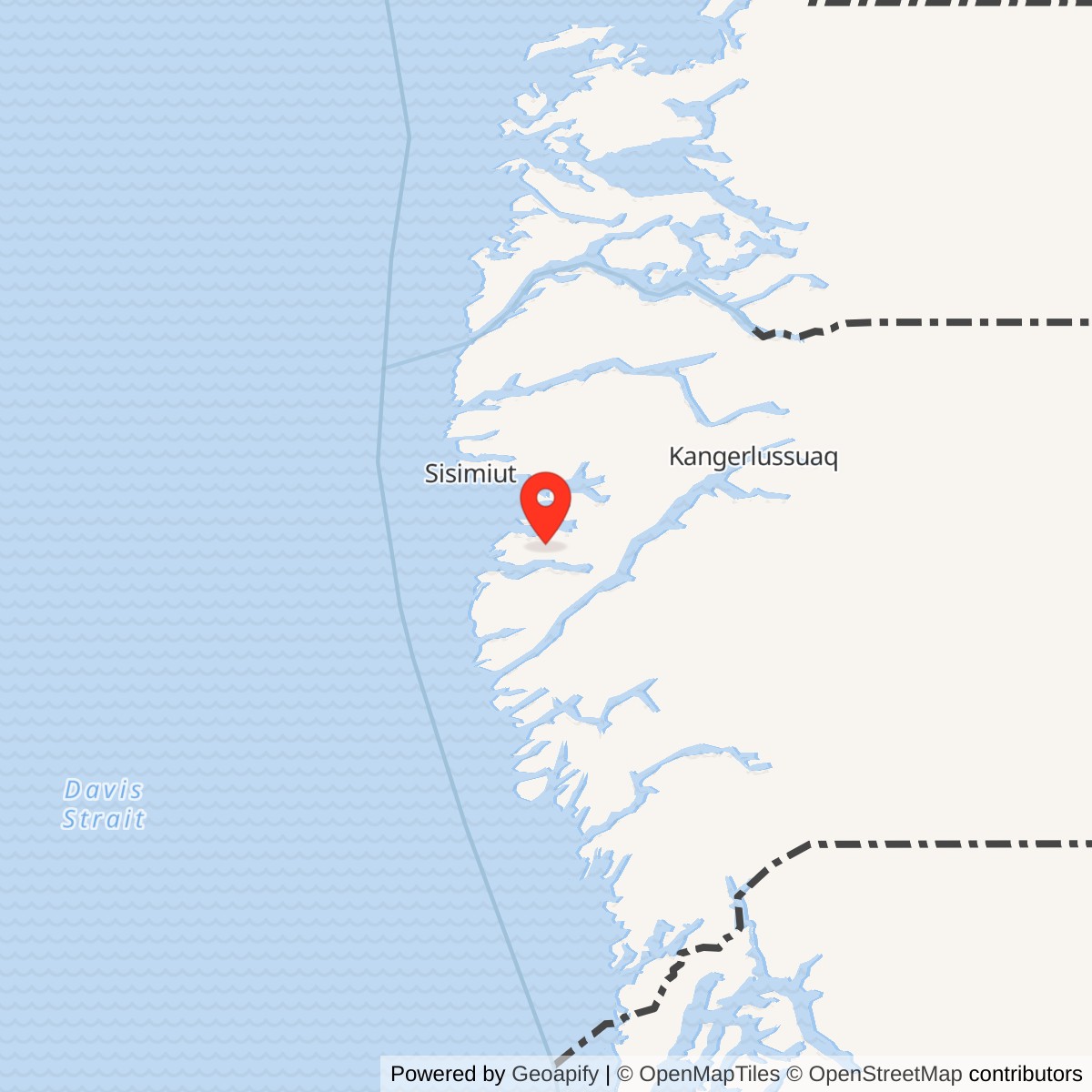
Longitude: -52.87
Site Number: DYE-1
Current Role: Former military radar station; main structures removed. Later radio facilities are documented in 1995 and 2013 records; present site-use status not independently confirmed.
Station reference point 66.63417, -52.87000. View map [4]
- DEW Line code
- DYE-1
- Role
- Auxiliary radar and communications station; later technical training site
- Radar
- AN/FPS-30 search radar
- Principal operation
- August 1, 1961 to 1988; limited later activity before final closure
- Historical leased area
- 162 acres
- Location
- Qaqqatoqaq mountain near Sisimiut, western Greenland
History
DYE-1 was the westernmost of the four Greenland stations added to the Distant Early Warning Line. Built on the mountain Qaqqatoqaq near Sisimiut, it placed an AN/FPS-30 surveillance radar and communications equipment above Greenland's rugged west coast. It entered service with DEW East on August 1, 1961. Regular radar operation ended in 1988, and the principal military buildings were subsequently removed. [2] [5]
The station connected the Canadian end of the warning chain with the Greenland ice-cap stations. It reported within the sector centered on Cape Dyer on Baffin Island, while Sondrestrom Air Base provided essential logistical support. Its warning mission concerned aircraft approaching North America, rather than the ballistic-missile detection mission of the separate Thule BMEWS installation. [10] [2]
Establishment and Mountain Construction
Construction at DYE-1 began on July 19, 1958. The Greenland extension required stations in very different terrain: a western mountain site at Qaqqatoqaq, two stations on the inland ice, and an eastern coastal mountain site at Kulusuk. DYE-1's bedrock foundation avoided the moving-ice problems that later troubled DYE-2 and DYE-3, but it imposed a steep transport problem between the coast and the summit. [3] [5]
Western Electric directed the extension's development. At DYE-1, construction depended on moving equipment and supplies onto a mountain without a practicable fixed-wing landing strip. Aircraft, coastal deliveries and the road-building effort were therefore parts of the station's establishment, not simply services added after the radar was finished. Construction-camp photographs show the temporary buildings, heavy equipment and deep snow surrounding the work. [3] [17]
The Air Force accepted the Greenland stations in October-November 1960, after which electronic installation proceeded. Equipment installation and testing delayed the intended July 1961 opening; DEW East became operational on August 1. The distinction between construction, Air Force acceptance and operational service explains why the station's establishment spans several years. [2] [12]
Summit Compound and Outlying Facilities
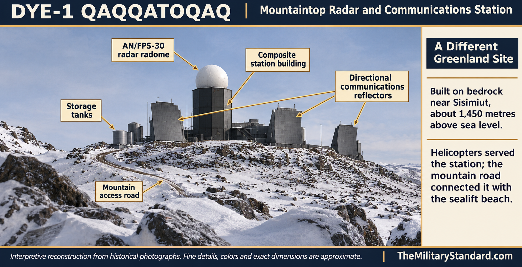
The summit stood about 4,750 feet above sea level. The historical station description records 162 acres leased for DYE-1. A composite building concentrated the permanent station's activities, with the radar radome rising prominently above the compound. Large directional communications structures and storage tanks accompanied the radar installation on the rocky summit. [1] [15]
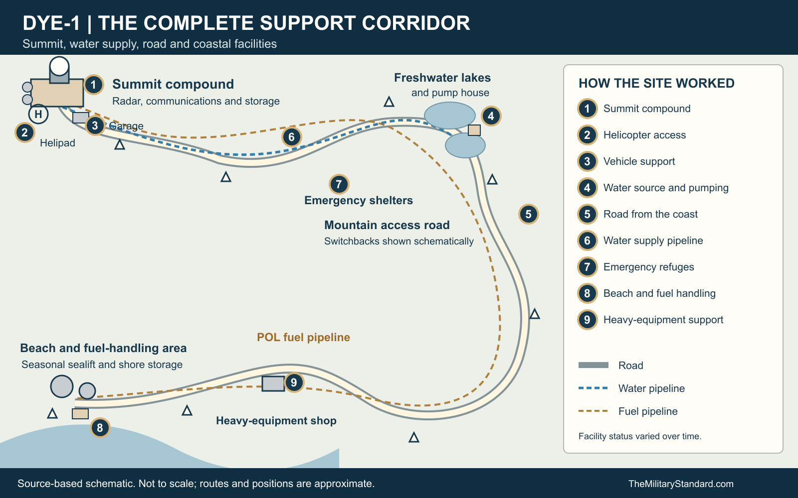
The station extended well beyond that compact skyline. Its site layout identifies a helicopter pad, garage, diesel storage and fuel-drum area near the upper compound. A road connected the summit with water-supply facilities and a separate coastal support area. Emergency shelters were distributed along the route, so the mountain watch relied on a chain of support points rather than one self-contained building. [9]
At the beach, the layout distinguishes the operational landing area, fuel storage, a POL pumphouse and a heavy-equipment shop farther along the road. The fuel and water systems followed different routes and served different purposes. The complete installation therefore included the summit electronics, the transport corridor and coastal handling facilities. A view of the radome alone leaves out much of the infrastructure needed to keep the station working. [9]
Radar and Communications
DYE-1 used the Bendix AN/FPS-30, the search radar selected for the four Greenland stations. The set operated between 570 and 630 megacycles per second, now expressed as megahertz, with a nominal peak power of 400 kilowatts. It combined radar and identification functions and was credited with detection ranges up to 200 nautical miles under suitable conditions. These were equipment capabilities, not a promise of identical coverage against every target in mountain terrain. [2]
The search radar supplied the local air picture; directional communications carried reporting through the extension. The Greenland stations were auxiliary sites reporting toward Cape Dyer, with communications continuing eastward through Greenland toward Iceland. DYE-1 thus combined surveillance with a communications position at the western end of the Greenland chain. The large exterior communications structures must be distinguished from the radar antenna protected by its dome. [10] [13]
Tests in September 1961 followed the opening of the extension. The official DEW Line history records successful detection and tracking of the test targets, including aircraft using chaff. Establishing the warning chain required the radar, identification equipment and reporting circuits to work together; acceptance of the buildings alone had not made the extension operational. [2] [12]
Helicopters, Sealift and Water Supply
There was insufficient suitable ground near DYE-1 for an airstrip. Helicopters provided access through most of the year. During the sealift season, ships and landing craft reached the beach at the head of Itidadlak Fjord, from which a 19-mile switchback road climbed to the station. The road was an essential part of the supply system, while the helicopter connection allowed personnel and urgent cargo to bypass the long ascent. [1]
Two insulated tanks, each holding 345,000 gallons, stored potable water near the composite building. Summer pumping filled them through a 40,000-foot pipeline from a freshwater lake. Ice- and snow-melting equipment supplied an emergency alternative. The stored annual water supply, pumping facilities and pipeline were therefore as important to maintaining the isolated crew as the more conspicuous radar equipment. [1]
The access route also drew attention after the military period. A Greenland geological survey described Qaqqatoqaq as a roughly 1,500-metre mountain reached by a long road from the coast. Its description reinforces the physical scale of the connection between landing point and summit. Movement of bulky supplies required a substantial inland journey after unloading at the shore. [14]
Operating Personnel and Support Organizations
The Greenland DYE stations operated with American and Danish personnel maintaining a continuous watch. At the coastal mountain sites, off-duty personnel could hike or fish, opportunities unavailable in the same form at the ice-cap stations. The workday remained governed by watchkeeping and equipment maintenance. Contact with Greenlandic communities was restricted in the earlier period, although the restrictions were not consistently observed and were relaxed later. [4]
Federal Electric held the operations and maintenance contract for the Greenland stations. Military oversight and logistical support remained essential, but contractor technical staffing should not be confused with a resident numbered radar squadron. The construction-support record includes the 20th Helicopter Squadron within the 314th Troop Carrier Wing's 1958 history, associated with air support for building DYE-1. [2] [8]
By 1983, Sondrestrom's 4684th Air Base Group formed part of the support structure for the Greenland DEW sites. Supplies reached Sondrestrom by sea and air before onward distribution. Scandinavian Airlines System carried Danish-purchased equipment and stores under an Air Force contract. Greenlandair's Sikorsky S-61 helicopters carried personnel, high-priority supplies and equipment specifically to DYE-1. [7]
The ski-equipped C-130 operation serving the ice-cap stations was a different transport arrangement. The contemporary account assigns the Raven Gang's annual fuel deliveries to DYE-2 and DYE-3 and its oversized-cargo missions to DYE-2 through DYE-4. DYE-1's helicopter access should therefore not be illustrated as a ski-aircraft landing at the mountain compound. [7]
A Working Station and Training Site
DYE-1 later gained an additional role in preparing technical personnel. When DEW Line classroom instruction moved from Streator to Colorado Springs in 1978, hands-on radician training was introduced at PIN-Main and DYE-1. Equipment theory could be taught at the school, while a working station provided access to the operational systems technicians would maintain. [6]
The training school moved again, to Winnipeg in 1982. Approximately two years later, equipment theory and practical training were consolidated at PIN-Main or DYE-1, while operations, weather and first-aid instruction remained at Winnipeg. The equipment phase generally lasted six to eight weeks. John Ovits is identified in the training recollections as the original Greenland instructor. This training function made DYE-1 more than a remote reporting post. [6]
A station personnel photograph dated January 1, 1965 and photographs of personnel at the fjord preserve a view of the community behind the technical mission. Construction and operating photographs also show how snow accumulated around the compound and vehicles. The same access route that supplied the warning watch connected the mountain workforce with the coastal landscape below. [16] [17]
Closure and the Former Station
The regular radar mission ended in 1988 as the Cold War warning network was reorganized. Danish heritage accounts group DYE-1 with the Greenland stations closed that year and distinguish DYE-4's later 1991 closure. DYE-1 was not converted into one of the Canadian North Warning System radar sites. [5]
Some limited activity continued beyond the principal closure period. A 1998 U.S. Army engineering retrospective records that DYE-1 maintained limited operations for a time before final closure. The main buildings were subsequently dismantled, and 1995 photographs show the former radar base and later radio installations. The surviving site therefore reflects several stages: the staffed radar station, its final reduced activity, removal of the major structures and later communications use. [11] [18] [5]
The bedrock sites and the ice-cap sites left different remains. At DYE-1 the major military structures could be removed from the mountain; DYE-2 and DYE-3 were left on the ice. The former road, foundations and support corridor continue to explain the scale of the effort required to keep a Cold War warning station operating on Qaqqatoqaq. [5]
Chronology
- July 19, 1958 Construction begins at DYE-1. [3]
- October-November 1960 The Air Force accepts the Greenland stations before electronic installation is completed. [2]
- August 1, 1961 DEW East enters operational service. [2] [12]
- September 1961 Operational tests exercise the Greenland extension's radar equipment. [2]
- January 1, 1965 A dated photograph records DYE-1 station personnel. [16]
- 1978 DYE-1 becomes a hands-on technical training location as classroom instruction moves to Colorado Springs. [6]
- 1983 A contemporary account documents Greenlandair helicopter support from Sondrestrom to DYE-1. [7]
- About 1984 Equipment theory and practical training are consolidated at DYE-1 or PIN-Main. [6]
- 1988 The principal radar operating period ends. [5]
- After 1988 Limited activity continues for a period before final closure and removal. [11]
- 1995 Photographs show the former radar base and later radio installations. [18] [1]
Related Sites
Information sources (18)
- WEBThe DEWLine, Site: DYE-1, historical description and photographs
Station setting, historical leased area, transport, water supply and dated photographs.
- WEBThomas W. Ray, A History of the DEW Line 1946-1964, ADC Historical Study No. 31, June 1965
Greenland extension acceptance, AN/FPS-30 specifications, contractor operation and 1961 service tests.
- PDFNORAD/CONAD Historical Summary, July-December 1958
Construction start at DYE-1 on July 19, 1958 and the eastern extension program.
- PDFJens Fog Jensen, Inge Bisgaard and Jens Heinrich, Anlaeg fra Den Kolde Krig i Groenland, Field Report 34, 2013
Danish and Greenlandic heritage account of station life, closure, later remains and the DYE-1 inventory coordinate.
- WEBDanish Agency for Culture and Palaces, 3. Dye radarstationer, updated July 24, 2019
The Greenland radar chain, bedrock versus ice-cap stations, 1988 closure and later removal.
- WEBTony Henriksen recollections, The Evolution of the DEWLine Training Centers, in DEWLine Memories
Hands-on training at DYE-1 after 1978 and later consolidation of radician training.
- PDFAIR FORCE Magazine, August 1983, page 71
Sondrestrom logistics, 4684th Air Base Group and Greenlandair helicopter support specifically serving DYE-1.
- PDFTania Metcalf, Annotated Bibliography: Distant Early Warning System, Alaska, CEMML for USAF, September 2008, entry 400
Archival lead identifying 20th Helicopter Squadron construction support at DYE-1 in 1958.
- WEBThe DEWLine, archived DYE-1 site layout
Relationship of summit compound, helipad, garage, water facilities, road, emergency shelters, fuel system and beach support area.
- PDFNORAD/CONAD Historical Summary, July-December 1960
Greenland auxiliary-station reporting to Cape Dyer and the extension communications arrangement.
- PDFMichael R. Walsh and Herbert T. Ueda, Structural Analysis of DEW Line Station DYE-2, Greenland, 1983-1988, CRREL Report 98-3, June 1998
Retrospective record that DYE-1 continued limited operations for a period after wider closures.
- PDFNORAD/CONAD Historical Summary, January-June 1961, page 43
Delay of DEW East activation to August 1, 1961 while radar and communications tests were completed.
- PDFNational Reconnaissance Office, declassified radar-location memorandum, C05025824
Independent historical identification of DYE-1 at Qaqqatoqaq as an ADC-controlled AN/FPS-30 site; approximate coordinate differs slightly from later inventories.
- PDFGeological Survey of Greenland, Open File Report 94/2, The Dye-1 Site, page 129
Independent description of the mountain location and the long road from the coast.
- WEBChris Gutscher, DYE-1 operating-station photograph, archived by The DEWLine
Visual evidence for the radar/composite-building and directional communications structures.
- WEBDYE-1 station personnel photograph, January 1, 1965, archived by The DEWLine
Dated personnel photograph; a group image is not an authorized staffing table.
- WEBPreben Bjornsholm, DYE-1 construction-camp photograph, archived by The DEWLine
Construction equipment, temporary accommodation and snow conditions.
- WEBPer Miller Jensen, former DYE-1 radar-base photograph, 1995, archived by The DEWLine
Physical remains of the former radar station after removal of the main structures.