
Cape Dyer DYE-Main DEW Line Station, Canada
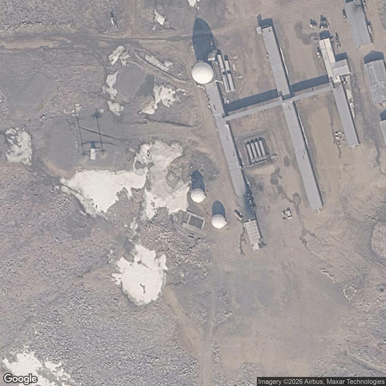
A high-ground radar watch and sector headquarters at the eastern end of the Canadian DEW Line.
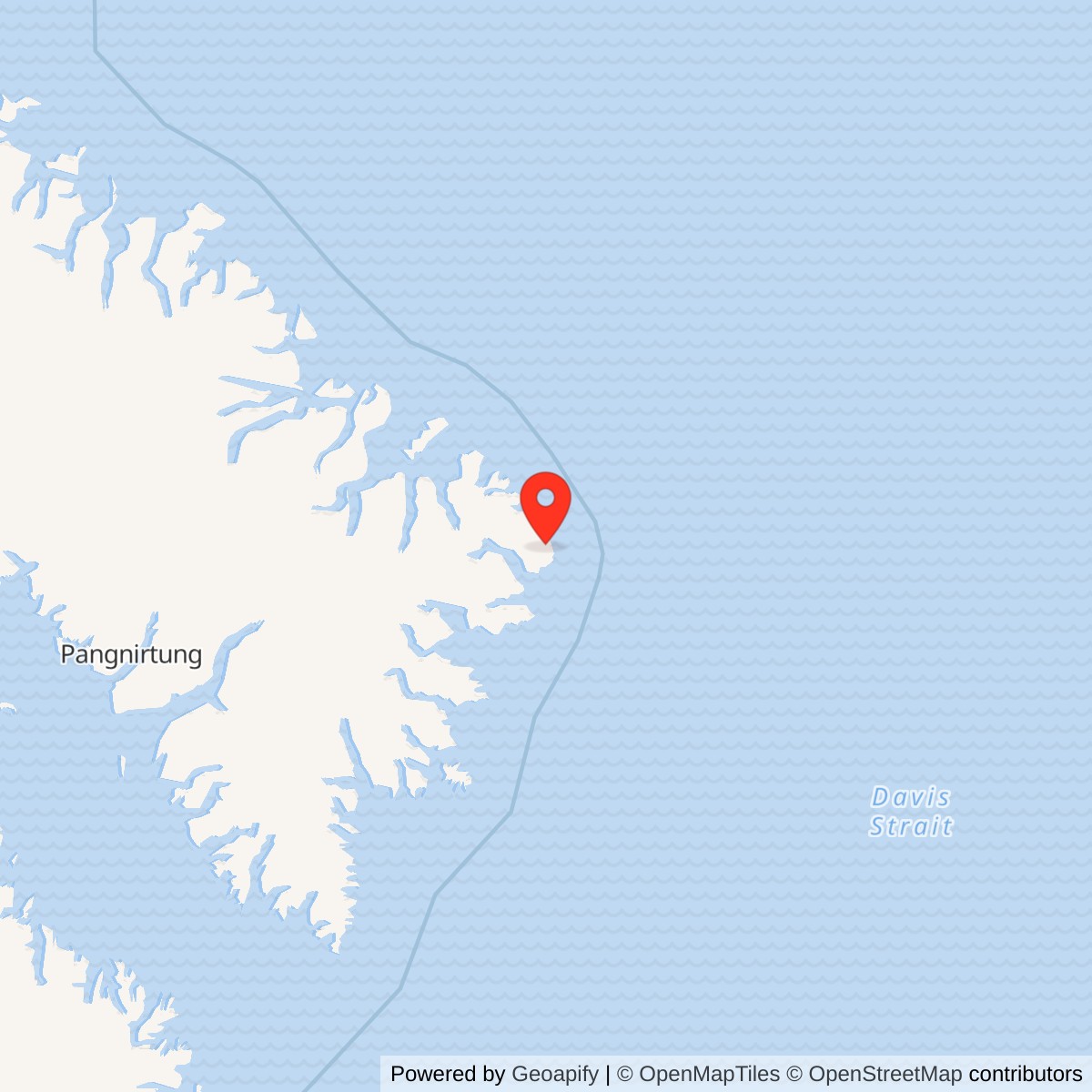
Longitude: -61.35750
Current Role: North Warning System successor radar site; legacy DEW facilities underwent remediation.
Radar-site reference point: 66.66444, -61.35750 (66°39′52″N, 61°21′27″W). View map [9]
- DEW Line code
- DYE-M / DYE-Main
- Role
- Main radar station and DYE sector data center
- Original radar
- AN/FPS-19 search radar and AN/FPS-23 Doppler receiver
- Successor radar
- AN/FPS-117 North Warning System long-range radar
- DEW operation
- 1957 to August 1989
- Location
- Cape Dyer, eastern Baffin Island, Nunavut, with separate upper radar and lower support camps
History
Cape Dyer was the eastern Canadian main station of the Distant Early Warning Line. Designated DYE-Main, it combined aircraft surveillance with a sector data center and communications connecting the Baffin Island chain to the Greenland extension. Its high-ground compound overlooked the Davis Strait side of Baffin Island, in what is now Nunavut. The original DEW mission began in 1957 and passed to the North Warning System in August 1989. [9] [11] [15]
The station belonged to the main-station tier of the original warning network. Smaller auxiliary and intermediate posts fed information toward these centers, where reports could be compared, aircraft movements assessed and warning passed onward. Cape Dyer consequently required both local radar equipment and the people and circuits needed to handle a sector watch. Its responsibilities extended beyond detecting an aircraft over its own horizon. [6]
Construction and the Two Camps
Cape Dyer developed during the 1955-57 construction of the original DEW Line. The project used prefabricated buildings and a coordinated system of aircraft, sealift and overland movement to establish isolated stations before the network entered service. Western Electric organized the construction program; Federal Electric subsequently operated and maintained the line under contract. At a main station the construction effort had to provide a data center as well as living accommodation, power and electronic equipment. [14]
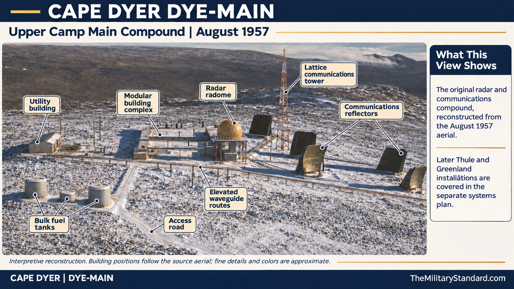
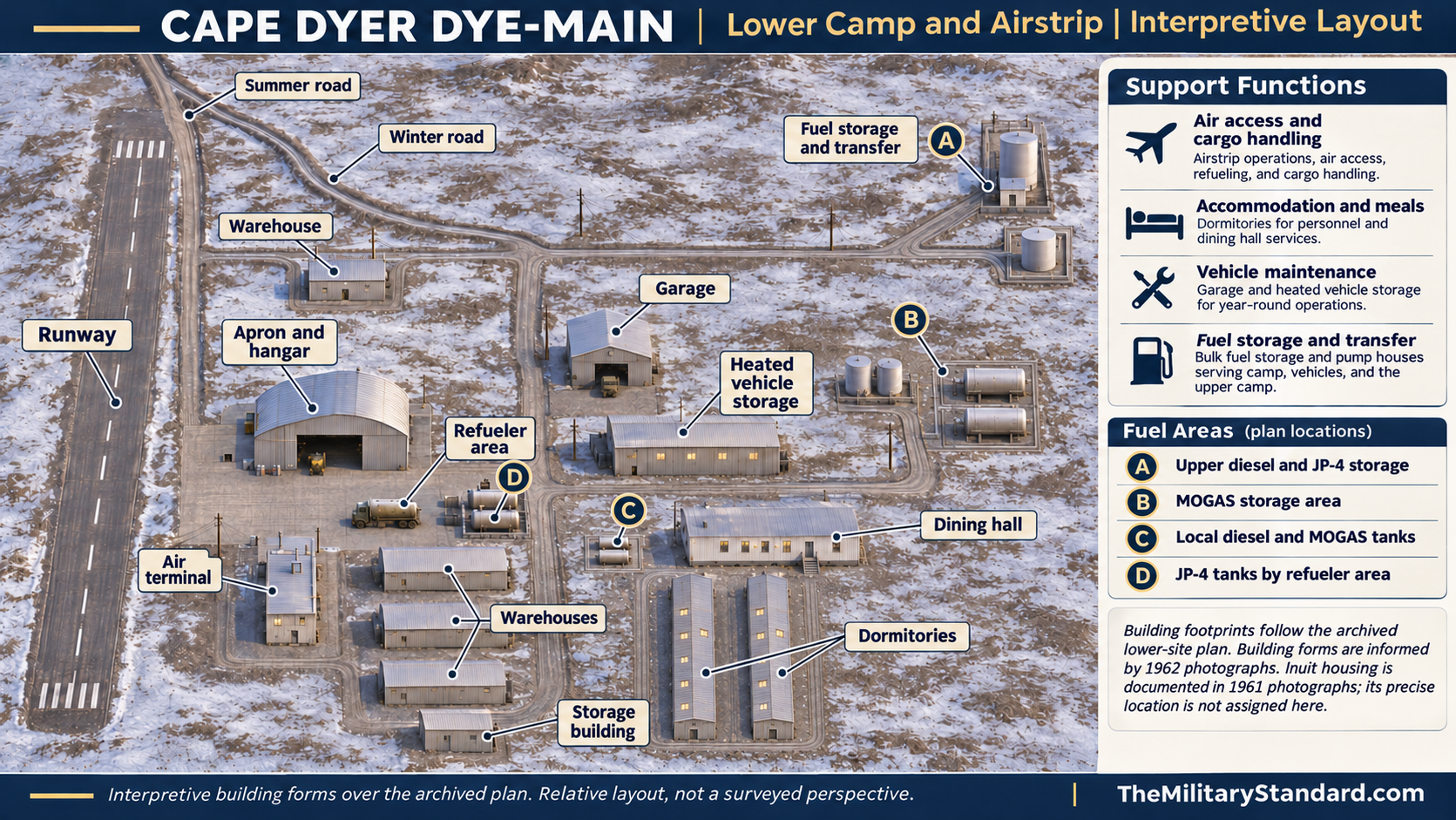
The upper camp stood about 2,300 feet above sea level; the lower camp and airstrip were roughly eight miles southwest, at about 1,200 feet. This separation gave the radar an elevated position while placing major aviation support elsewhere. Ron Fry recalled a middle construction camp near the upper modules and a 1957 sealift whose cargo was hauled inland by tracked vehicles. These were distinct working areas within a much larger support installation. [2]
The coastal geography imposed another division between the summit and the supply route. Canadian sailing directions locate former beaching and airstrip facilities in Sunneshine Fiord west of the cape, with the radar installations on high ground north-northwest of the cape itself. A delivery arriving at the shore therefore still needed inland transport before it could sustain the upper watch. The coastal landing facilities and elevated radar compound should be understood as parts of one installation, rather than as a single compact camp. [11]
Radar, Data Center and the Warning Watch
The original main-station equipment included AN/FPS-19 search radar and an AN/FPS-23 Doppler receiver. The search set provided surveillance around the station; the Doppler network addressed low-altitude passages between stations. Main-station personnel assembled reports and compared them with flight information. These functions made communications and identification work inseparable from the radar watch. [1]
Sector headquarters carried operational, administrative and logistical responsibilities. Civilian contractor personnel kept the equipment operating while military personnel supervised warning functions. Reports had to move from remote sensors to a data center, then onward to the air-defense command structure. The resulting warning depended on sustained communications and interpretation as well as a functioning transmitter and antenna. [6]
The work of a civilian radician combined radio, radar and electronics skills. At isolated stations, technical duties existed alongside the practical requirements of an enclosed working community. The same installation needed reliable diesel power, heat, food service, repair work and supplies. Prefabricated module accommodation reduced exposure during the working day, but outside maintenance and movement between facilities still depended on Arctic conditions. [7]
Canadian Command and NORAD Control
A USAF directive dated January 17, 1958 assigned ADC operational control of the Cape Lisburne-Cape Dyer line effective February 15. The directive also retained the existing contract-administration arrangement. Cape Dyer was thus part of a formally coordinated warning system whose operational chain and contractor support arrangements were specified separately. [3]
In February 1959, a revised main-station military establishment placed an RCAF squadron leader in the sector commander position, with five RCAF and two USAF officers at each Canadian main data center. The two American positions included a director and a liaison officer concerned with contractor and support-wing coordination. [1]
NORAD Operations Plan 3-59 took effect on October 1, 1959. It delegated control of the relevant DEW Line sections to the Alaskan and Northern NORAD regional commanders. ADC retained its responsibilities for contract administration, logistics and operation of the original line. The change brought the regional warning watch into NORAD's operational framework while preserving the support machinery required to keep remote stations functioning. [4]
Greenland, Thule and Project Dewdrop
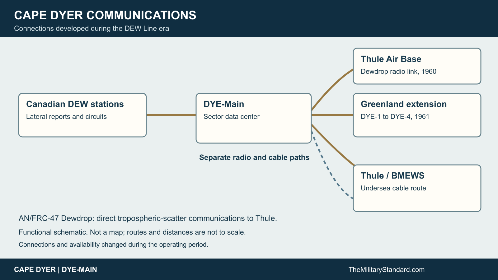
The Greenland extension became operational in 1961. Cape Dyer served as its western main-station connection, giving the DYE sector an important position at the transition from the Canadian chain to Greenland. The four Greenland radar stations reported to the Cape Dyer data center as its eastern auxiliary stations. Their new tropospheric-scatter terminals connected the extension with Cape Dyer and Iceland. [15] [16]
A separate link to Thule expanded Cape Dyer's communications role. Project Dewdrop entered service in autumn 1960, using AN/FRC-47 equipment on a single tropospheric-scatter hop. The contractor's published account gives the distance as 691 statute miles. This was a long communications circuit rather than an additional local surveillance radar. [5]
Dewdrop initially suffered serious equipment and spare-parts problems. Federal Electric reported 700 hours of circuit outage in its initial operating quarter after the link entered the reporting system in December 1960. The later improvement depended on resolving equipment defects and supply problems. Across the DEW system, better manuals, preventive maintenance, parts quality and procurement reduced outages as the equipment matured. [5]
Cape Dyer also lay on an undersea cable route associated with the Ballistic Missile Early Warning System at Thule. Canadian defence history records three incidents in 1961 in which Soviet trawlers were suspected of cutting the Cape Dyer-Thule cables. Intentional damage was not established. The incidents nevertheless show why a station built for bomber warning became part of the communications infrastructure supporting missile warning. [13]
Daily Life, Transport and Aviation Loss
Water had to be hauled to both camps: the historical station description gives round trips of six miles for the upper camp and four for the lower. Fry recalled rules requiring Arctic clothing, sleeping bags and vehicle transport for excursions. His account of becoming disoriented in fog illustrates how quickly an ordinary movement outside could become hazardous. [2]
The isolated watch brought technicians into a setting where accommodation, recreation and meals were part of the same station community. Supplies and replacement parts arrived through a seasonal transport system, and a technical failure could persist when the necessary component was unavailable. The contractor response included changes to preventive maintenance and the management of spares, linking everyday workshop practice directly to the availability of the warning network. [14] [7]
On May 15, 1967, Nordair Curtiss C-46 CF-NAD crashed while approaching Cape Dyer. The aircraft struck terrain short of the runway in whiteout conditions. Both crew members and both passengers were killed. The loss was a severe reminder of the aviation risks involved in sustaining the station. The flight was civilian support transport, not a combat aircraft loss. [8]
North Warning System Conversion and the Former DEW Facilities
The station inventory dates the end of Cape Dyer's DEW operations and the establishment of its NWS long-range radar site to August 1989. The successor equipment was AN/FPS-117. This was a conversion of the warning function at Cape Dyer, not the disappearance of radar coverage from the location. The NWS arrangement reduced dependence on the resident workforce required by the earlier system. [9] [10]
The obsolete DEW infrastructure also required environmental remediation. In its 2019-20 supplementary-estimates material, National Defence reported $105.9 million for the Cape Dyer DEW Main station. That expenditure concerned the legacy installation; it should not be read as a date for the termination of the successor radar mission. The surviving high-ground facilities and former coastal support areas preserve the physical distinction between the warning watch and the transport system that supported it. [11] [12]
Chronology
- 1955-57: The original DEW Line construction program establishes the main-station network. [14]
- 1957: Cape Dyer enters the original DEW Line warning network. [9]
- February 15, 1958: ADC assumes operational control of the original line. [3]
- February 1959: The Canadian main-station military staffing change takes effect. [1]
- October 1, 1959: NORAD Operations Plan 3-59 becomes effective. [4]
- Autumn 1960: Project Dewdrop adds the FRC-47 communications link to Thule. [5]
- 1961: The Greenland extension becomes operational. [16]
- May 15, 1967: Nordair C-46 CF-NAD crashes on approach, killing four people. [8]
- August 1989: Cape Dyer transitions from DEW operations to NWS long-range radar. [9] [10]
- 2019: National Defence reports Cape Dyer legacy-site remediation expenditure. [12]
Related Sites
Information sources (16)
- WEBThomas W. Ray, A History of the DEW Line 1946-1964, ADC Historical Study No. 31, June 1965
Official history of main-station equipment, personnel, command changes and the Greenland extension.
- WEBThe DEWLine, DYE-Main site description and contributor recollections
Cape Dyer terrain, construction, camp layout, water hauling and firsthand experiences.
- PDFNORAD/CONAD Historical Summary, July-December 1957, Volume III, USAF letter of January 17, 1958
The February 15, 1958 assignment of DEW Line operational control to ADC.
- PDFNORAD/CONAD Historical Summary, July-December 1959
Operations Plan 3-59, regional operational control and retained ADC support responsibilities.
- PDFWilliam G. Donaldson, Dewline After a Decade of Field Operation and Maintenance, Electrical Communication 40(3), 1965, pages 369-380
Contractor account of the FRC-47 Dewdrop link, its early outages and maintenance improvements.
- WEBDEWLine Museum, Operations, reproduced late-DEW-era overview
Sector headquarters responsibilities, civilian operations and the warning mission.
- WEBPaul Kelley, The DEWline - A Brief Introduction
Firsthand technical background on DEW Line station types, civilian radicians and station life.
- WEBBureau of Aircraft Accidents Archives, Cape Dyer, May 15, 1967
CF-NAD accident date, aircraft, occupants and approach location.
- PDFThe DEW Line: Bibliography and Documentary Resource List, station inventory
Cape Dyer identification and August 1989 DEW-to-NWS transition.
- WEBThe DEWLine, North Warning System station inventory
DYE-M identification and AN/FPS-117 successor radar.
- PDFCanadian Hydrographic Service, Sailing Directions ARC 402, Eastern Arctic, Chapter 3
Cape Dyer coastal geography, high-ground radar installations and former Sunneshine Fiord facilities.
- WEBDepartment of National Defence, Infrastructure et environnement, Supplementary Estimates A 2019-20
Federal reporting of Cape Dyer DEW Main remediation expenditure.
- PDFDepartment of National Defence, Exceptional Circumstances: Canada's Maritime Response to the Cuban Missile Crisis
BMEWS cable incidents in 1961 and uncertainty about their cause.
- WEBWestern Electric construction account, reproduced in Lynden T. Harris, The DEWLine Chronicles
Original construction program, transport, prefabrication and contractor arrangements.
- PDFNORAD/CONAD Historical Summary, July-December 1960
Cape Dyer data-center relationship to the Greenland auxiliary stations and extension communications.
- PDFNORAD/CONAD Historical Summary, January-June 1961
The revised August 1961 operational date for the Greenland extension.