
Naknek Army Air Base / Naknek Army Air Field, Alaska
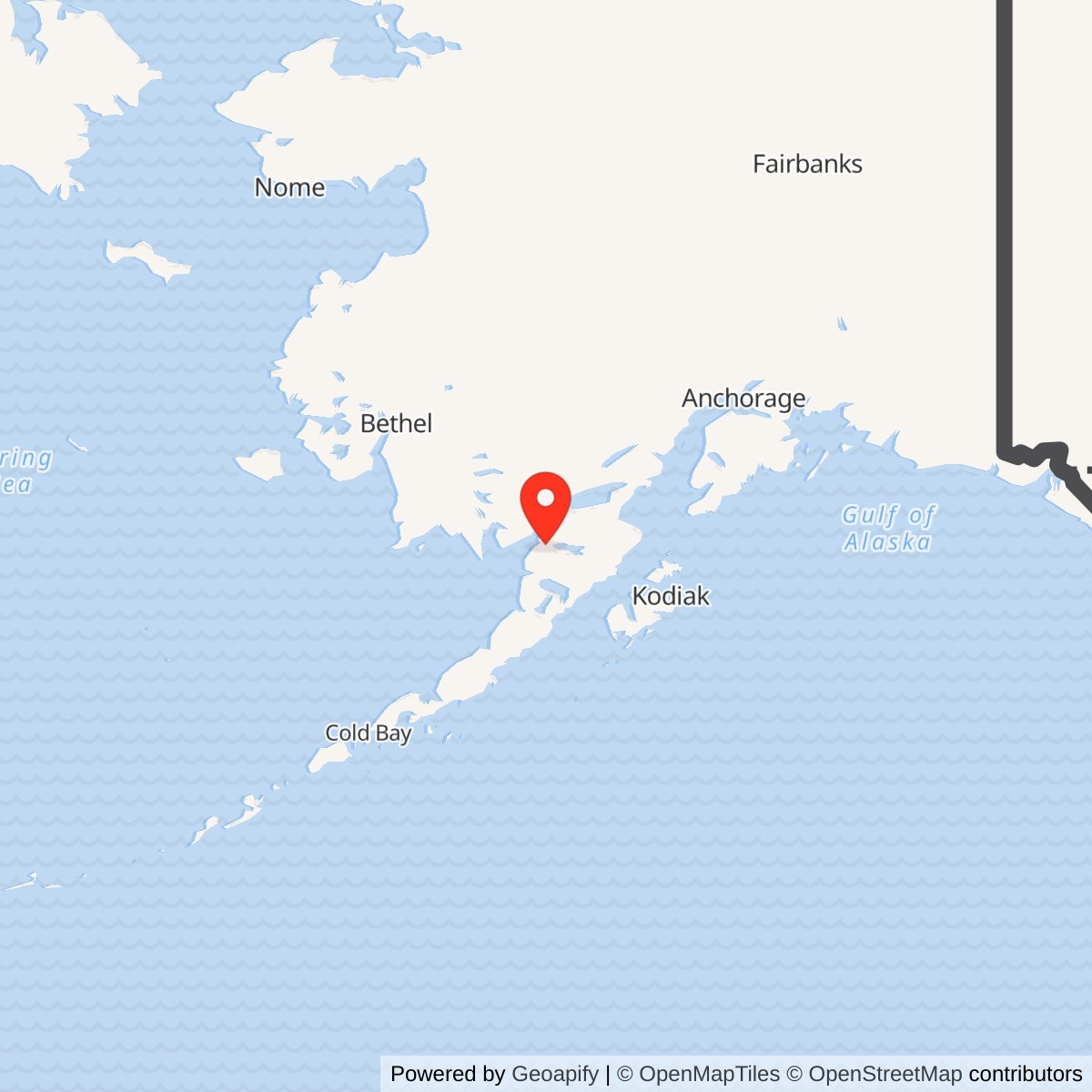
Longitude: -156.6491670
Current Role: Present King Salmon Airport on the wartime airfield landscape, with a later distinct U.S. Air Force forward operating location. The King Salmon radar station is a separate installation and physical site. Present ownership and environmental management vary by parcel.
- Identity
- World War II Army air base at today's King Salmon Airport
- Representative location
- 58.676667 N, 156.649167 W. 1997 FAA airport-location reference, not a wartime base centroid or property boundary.
- Related site
- King Salmon Air Station was the later Air Force airfield and fighter-alert use.
Identity and landscape
Naknek Army Air Base was the World War II Army installation at the airfield now known as King Salmon Airport. It was not at today's separate Naknek Airport near the village of Naknek, and it was not the Air Force radar station built at King Salmon after the war. The name described the Naknek region and its military aviation function, while the actual field stood near the Naknek River at the place that developed into King Salmon. The later Air Force forward operating location reused this airfield landscape, so the Army predecessor and Air Force successor occupy the same physical airfield site. The King Salmon Aircraft Control and Warning installation occupies a separate radar site.
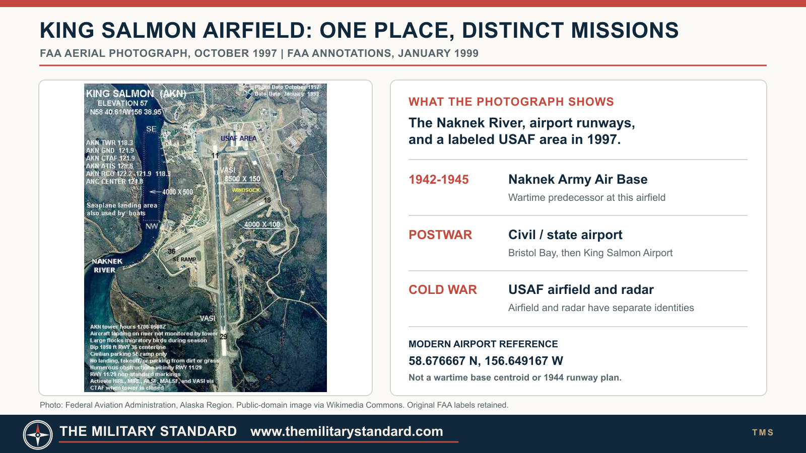
The modern King Salmon Airport reference shown on a 1997 Federal Aviation Administration aerial is approximately 58.676667 N, 156.649167 W. This is a modern airport-location reference and does not identify an Army headquarters doorway, wartime runway threshold, legal property corner, or surveyed wartime base centroid. The airfield lies roughly 15 miles east of the older settlement of Naknek, along the river corridor between Bristol Bay and Naknek Lake. That placement gave aircraft a relatively level operating surface and a practical link to the region's river and coastal supply routes. It also separated the airfield from the village whose name it carried, a distinction important when identifying photographs and maps.
Selection and construction
Federal civil aviation had established an airport and related facilities at King Salmon before the Army expansion. The Alaska State Historic Preservation Office dates the Civil Aeronautics Authority establishment to 1931 and transfer to Army use to 1941. A later Air Force environmental history instead describes CAA runway construction in 1940 and Army transfer in 1942. The accounts may be describing different stages of development and property control, but they cannot be made identical from the cited summaries alone. The defensible conclusion is that civil aviation preceded the wartime Army buildout. Neither 1931 nor 1940 should be used as the opening date of Naknek Army Air Base.
An Alaska Department of Fish and Game community study adds a revealing site-selection detail. In 1941 military planners first favored ground about half a mile north of Naknek, then consulted local residents and chose flatter land approximately 15 miles east. That decision helps explain why the wartime base was called Naknek yet the subsequent airport and community became King Salmon. It also shows that the installation was not simply dropped onto a blank map. Nearby residents knew the ground, its drainage, and its suitability for a large aviation project. The study describes a lightly developed landscape at the selected location, but that should not be read as saying the wider region was unoccupied or unused by Alaska Native communities.
Construction began on 1 July 1942. The physical station was considered complete on 22 September 1943, while airstrip paving and other improvements continued through 1944. These dates describe a construction sequence, not a claim that every building, runway surface, and support system appeared at once. The Army had to convert a remote civil field into a reliable place to land, refuel, inspect, service, and dispatch wartime aircraft. Fuel storage, maintenance and transportation functions, quarters, communications, medical support, and supply were necessary to make the strip a useful staging point. Available public histories establish those functional needs, but do not provide a verified building-by-building 1943 plan or a wartime surveyed boundary.
The war role
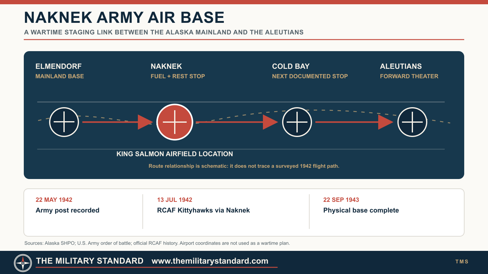
The state preservation history describes Naknek as a satellite of Elmendorf Army Air Base and a fuel and rest stop for aircraft moving toward the Aleutians. A 2017 Air Force restoration review calls it an advanced staging base and fuel stop for aircraft deploying to and from the islands. Those statements describe more than an emergency landing field. Naknek helped bridge the long distances and difficult flying weather between the Alaska mainland and forward bases. Transient crews could break a journey, obtain fuel and servicing, and continue toward a changing wartime operating area. Its contribution was logistical and operational support, not a documented independent bombing or fighter mission flown by a permanent Naknek combat wing.
One documented movement makes that staging role concrete. Canada's official history of the Royal Canadian Air Force says Wing Commander McGregor led the first group of six Kittyhawk pilots west on 13 July 1942 by way of Naknek and Cold Bay, with transports carrying additional pilots, ground crew, and support staff. This was early in the Army construction period, well before the 1943 physical-completion milestone. It demonstrates that aviation use and continuing construction could overlap. It also shows Naknek's utility to allied forces moving through the Alaska theater, without making the Canadian detachment a permanently assigned Naknek unit.
The broader Alaska aircraft-ferry network also appears in the source record. The Alaska Department of Fish and Game study says Naknek supported operations throughout Alaska, especially the Alaska-Siberia aircraft ferry route. That wording should not be transformed into a claim that King Salmon was the principal ALSIB handover field, that every Lend-Lease aircraft used Naknek, or that a specific unverified flight path passed through it. The well-documented Aleutian staging role is the firmer local description. Air Transport Command associations are plausible in this aviation system, but the available official material used does not establish a complete Naknek station-unit roster or an exact date when one service command displaced another. The route graphic supplied with this history is therefore a functional network schematic, not a flight chart.
Naknek also functioned as an Army post with people and services beyond aircraft crews. A U.S. Army order of battle records a Naknek, Alaska, U.S. Troops post activated on 22 May 1942, placed in inactive status on 1 December 1943, and notes that Naknek Post was redesignated Naknek Army Air Base on 15 August 1944. These administrative entries do not erase the 1 July 1942 air-base construction start, nor do they prove the airfield was closed during the 1943 post-status change. They describe changes in the Army ground-forces post record while the aviation facilities followed their own construction and operating history. A U.S. Army medical history maps a Naknek Post Station Hospital, confirming a local medical support function, although it does not by itself identify its buildings or prove continuous occupancy for every wartime month.
The Army Medical Department's supply history gives a rare glimpse of daily operating conditions: at Naknek, medical supplies froze on shelves even in heated buildings. That observation is not a weather statistic or a comprehensive building assessment, but it explains why remote support required more than a runway and a fuel pump. Heat, storage, insulation, shipping, and replacement supplies all affected whether the post could keep crews and support staff functioning. It also cautions against assuming that a completed construction report meant every service operated without friction in the Alaska climate.
People, community, and recreation
The war brought construction workers, military personnel, aircrews, and support employees into the Naknek-King Salmon area. Alaska State Library's 1944 Naknek Air Base photograph collection includes aircraft, buildings, personnel, activities, and aerial views. The collection is a valuable lead for identifying actual wartime structures and aircraft, but its access rules prohibit photocopying, so its images have not been reproduced in this deliverable. An Alaska historical study of Katmai also records military rest and recreation activity extending upriver. It says enlisted men used Naknek Recreation Annex No. 1 at Rapids Camp and officers used Annex No. 2 at Lake Camp in the war period. Later Air Force recreation facilities also existed in the same general area; the existence of both eras should not be collapsed into a single uninterrupted camp operation without parcel and document verification.
The nearby communities were not incidental background to the base. The 1941 site-selection account explicitly credits consultation with residents, and the later growth of King Salmon was tied to government aviation and services. The airfield also connected Bristol Bay communities to regional transportation beyond the war. Oral and local-history evidence may clarify the effect on work, land use, fishing, and settlement.
Transition from Army base to civil airport
The end of World War II did not mean the runway vanished. The Alaska preservation account says the airfield returned to the Civil Aeronautics Authority as Bristol Bay Airfield after the war. The 2017 Air Force environmental review dates the return of control to 1945, while the community study distinguishes the transferred runway from the rest of the physical station, which remained under military control. This is a useful warning against a single blanket transfer date for every building and parcel. A complete deed and jurisdiction chain for the entire wartime base has not been established here. The Army air-base mission ended in the postwar transition, but the aviation site endured as a civil airport with federal military interests nearby.
Alaskan Air Command began using the airport as a forward operating location in 1948. The Cold War Air Force subsequently added fighter-alert infrastructure and the King Salmon AC&W radar station, which opened in November 1951. The airfield and support complex took the King Salmon Air Station name in 1954, and the state assumed airport ownership in 1959 while the Air Force remained a tenant. These later installations are part of the site's reuse, not retrospective components of a 1942 Army base. The 1997 FAA aerial supplied as a contextual photograph shows the later airport runways, river, and labeled USAF area. It is explicitly not evidence of the precise WWII runway geometry or wartime building footprint.
Physical remains, environment, and present use
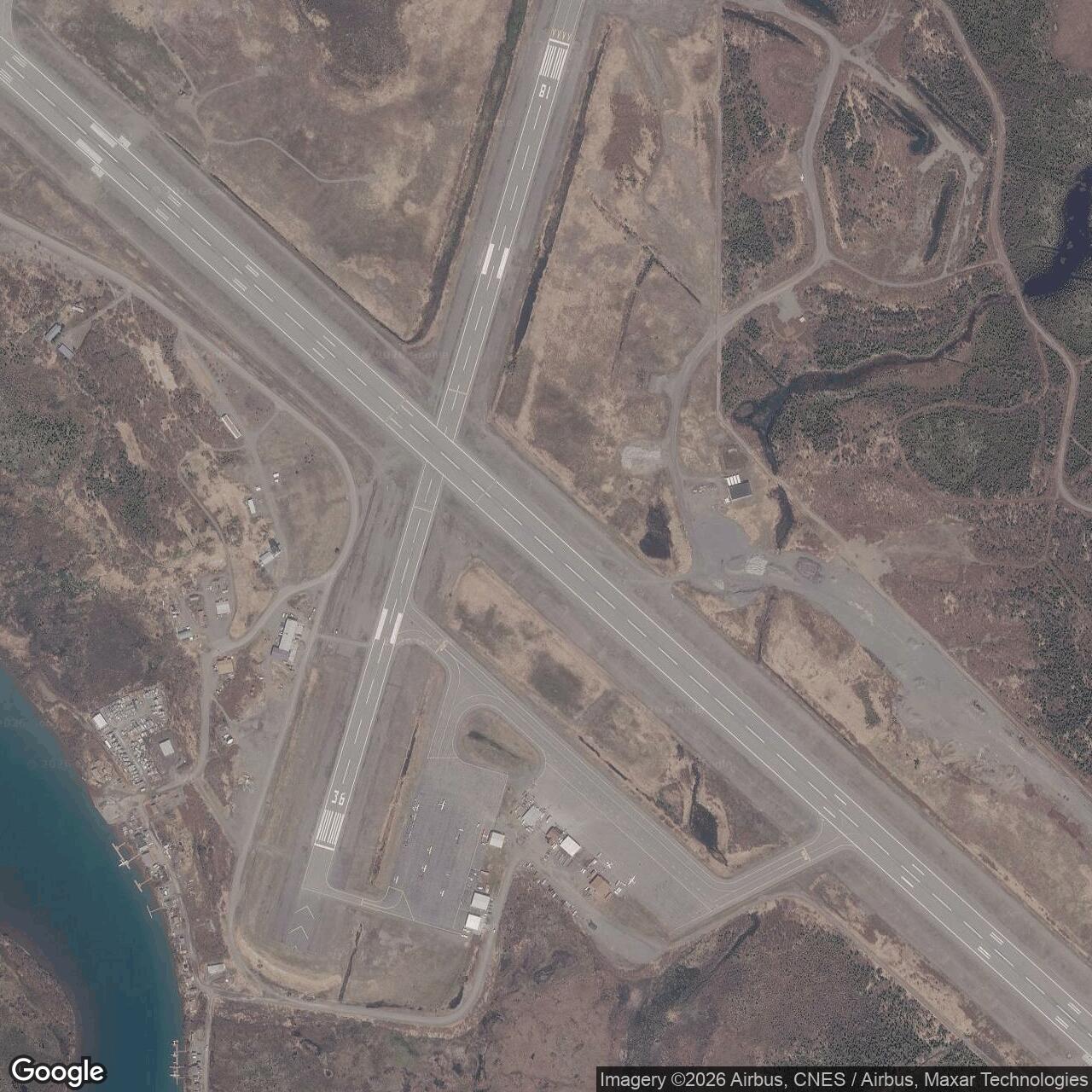
The 1942-1944 construction episode created the airfield nucleus of a place that was repeatedly rebuilt. Later runway paving, Cold War radar and fighter facilities, airport improvements, demolition, and environmental restoration make it difficult to identify a standing structure as specifically wartime Army work without a dated plan and architectural evaluation. The Alaska preservation study's 727-acre figure describes a later, wider King Salmon multi-area military installation and cannot be assigned to Naknek Army Air Base. No reliable wartime Army-only acreage or polygon was found. The modern state-run King Salmon Airport remains active; the Air Force radar site remains a separate active surveillance installation.
Environmental records are also organized by later King Salmon Air Station zones and named subsites, not by a clean line around the wartime Army base. The 2017 five-year review says Army facilities occupied areas corresponding to later Groundwater Zones 1, 2, and 4, but that statement is a land-use history, not a finding that every present contaminant originated in 1942-1945. Fuel storage, disposal, and subsequent decades of use overlap. Alaska Department of Environmental Conservation cases must be checked individually for status and controls before describing a particular parcel as remediated or unrestricted. The history therefore treats the wartime footprint as a predecessor landscape and avoids assigning a present-day contamination condition to all of it.
Role in the Wider Military Network
Naknek filled a distance problem in wartime Alaska. Elmendorf supplied the larger rear-area aviation base; Naknek gave aircraft heading southwest a place to stop and recover before or after the Aleutian leg. The Army post and its medical and supply functions supported the people who made that staging role possible. The airfield's continued utility explains its quick postwar civil reuse and its later selection for an Air Force forward operating base. Its relationship to the later King Salmon radar is chronological and geographic rather than functional continuity: the radar station did not operate during the Army air-base years.
Chronology
- 1931 Alaska preservation history dates the initial Civil Aeronautics Authority airport and associated facilities at King Salmon; a later environmental account gives 1940 for runway construction.
- 1941 Preservation history dates CAA transfer to Army use; local-history study describes relocation of the planned Naknek-area airfield about 15 miles east to flatter ground.
- 1942-05-22 Army ground-forces order of battle lists activation of the Naknek, Alaska, U.S. Troops post.
- 1942-07-01 Construction of the Naknek wartime air base begins.
- 1942-07-13 RCAF Kittyhawk pilots begin their movement west via Naknek and Cold Bay, documenting early wartime transit use.
- 1943-09-22 Physical station is reported complete, with further improvements still needed.
- 1943-12-01 Army ground-forces record places the Naknek, Alaska, U.S. Troops post in inactive status; this is not proof that airfield operations stopped.
- 1944 Airstrip paving and other base improvements continue; Alaska State Library's Naknek Air Base photo collection records the site and its people.
- 1944-08-15 Army order of battle records redesignation of Naknek Post as Naknek Army Air Base.
- 1945 Air Force environmental history says control of facilities returned to the CAA as Bristol Bay Airfield; another study distinguishes the runway from other military-controlled physical areas.
- 1948 Alaskan Air Command begins postwar forward operating use as an airport tenant.
- 1951-11 Separate King Salmon AC&W radar station becomes operational.
- 1954 Later airfield and military support complex takes the King Salmon Air Station name.
- 1959 Airport ownership passes to the State of Alaska while the Air Force retains a tenant interest.
- 1997-10 FAA aerial documents the later airport setting, not the 1944 layout.
- 2026 King Salmon Airport remains a civil aviation field; wartime Army-only boundary, acreage, complete building roster, and exact postwar deed chain remain unverified.
Information sources (11)
- PDFDefending Attack From the North: Alaska's Forward Operating Bases During the Cold War, Alaska State Historic Preservation Office / Argonne National Laboratory for the U.S. Air Force
Source for CAA predecessor, Army construction period, Elmendorf satellite and Aleutian fuel/rest role, postwar civil return, and later Air Force reuse.
- PDFKing Salmon Divert and Naknek Recreation Camps 2017 Five-Year Review, U.S. Air Force / Alaska Department of Environmental Conservation
Source for wartime staging role, Groundwater Zones associated with Army facilities, postwar CAA and Air Force phases, and subsite-specific environmental context.
- PDFTechnical Paper 470: Bristol Bay area community study, Alaska Department of Fish and Game
Source for Naknek-area airfield selection account, detailed construction milestones, runway paving, ALSIB mention, and qualified runway-versus-remaining-property transfer distinction.
- WEBOrder of Battle of the United States Army Ground Forces in World War II, Pacific Theater of Operations, Department of the Army, 1959
Source for Naknek U.S. Troops post activation and inactive-status dates and the recorded 15 August 1944 Naknek Post redesignation.
- PDFMedical Service in the War Against Japan, U.S. Army Center of Military History
Source for Naknek Post Station Hospital identification and medical-support context; not a building inventory.
- WEBMedical Supply in the War Against Japan, Chapter XII, U.S. Army Medical Department Center of History and Heritage
Source for the documented freezing of medical supplies on shelves at Naknek despite heated buildings.
- PDFThe Official History of the Royal Canadian Air Force, Volume II, Part Three: The Air Defence of Canada, 1939-1945, Department of National Defence Canada
Source for the 13 July 1942 Kittyhawk transit via Naknek and Cold Bay, with supporting transport aircraft.
- PDFTourism in Katmai Country, National Park Service historical study hosted by Alaska Department of Natural Resources
Source for wartime Naknek-area recreation annexes and military personnel activity; later camp phases require separate dating.
- WEBNaknek Air Base Collection, 1944, Alaska State Library Historical Collections
Source for existence, subject coverage, dating, and copying restrictions of the wartime photograph collection.
- WEBFAA King Salmon Airport annotated aerial, Federal Aviation Administration, October 1997 photograph and January 1999 labels
Source for the explicitly modern airport location reference, later runway landscape and public-domain contextual photograph.
- WEBKing Salmon Airport Runway 18-36 Rehabilitation, Alaska Department of Transportation and Public Facilities
Source for current state airport improvement activity, not wartime runway geometry.