Bishop Army Air Field / Bishop Airport / Eastern Sierra Regional Airport, California
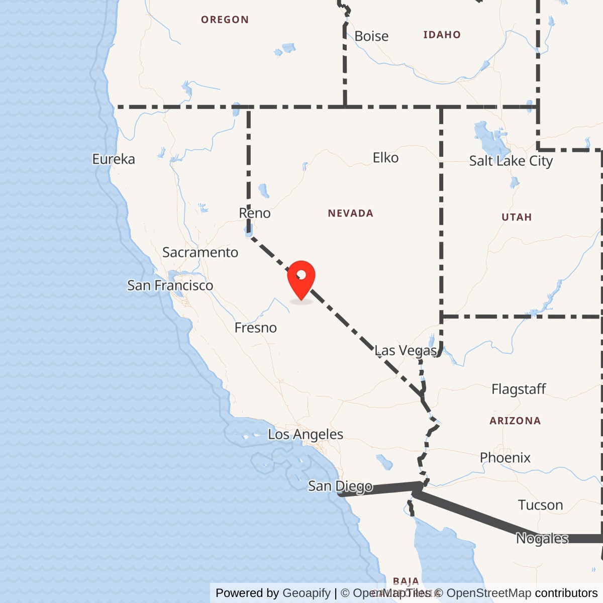
Longitude: -118.3636111
Airport ICAO ID: KBIH
Official Base Website: Bishop Airport
Current Role: Bishop Airport / Eastern Sierra Regional Airport, BIH/KBIH, active public airport operated by Inyo County on City of Los Angeles / Los Angeles Department of Water and Power-owned land.
Bishop Army Air Field was a World War II Army Air Forces use of a prewar civil airport in the Owens Valley, east of Bishop and below the wall of the Sierra Nevada. Its military value came from the same qualities that still make the airport useful today: clear inland flying space, long approaches, high-desert visibility, and enough room to expand a small civil field into a wartime training and support airfield. The field was not a permanent post in the style of a large Army camp or a later Air Force base. It was a wartime Army Air Forces field, tied to the Fourth Air Force training system and to nearby high-desert air installations, then returned to civil control after the war.
The modern airport is Bishop Airport, also marketed as Eastern Sierra Regional Airport. AirNav's FAA-derived airport record identifies the field as Bishop Airport, FAA identifier BIH. The same record identifies the owner as the City of Los Angeles and the public operator as Inyo County. The 2002 Bishop Airport Master Plan describes the airport as an 831-acre site approximately two miles east of Bishop, owned by the Los Angeles Department of Water and Power and leased to Inyo County for operation, maintenance, and development. That civil ownership and county operation are central to the site's identity. Bishop was a civil airport before World War II, became an Army Air Forces field during the emergency, and then resumed its civil airport role.
Mission Evolution
The Bishop airport story began before the war. Local aviation history places the beginning of Bishop airport construction on March 22, 1928, and the airport master plan states that the original airport lease arrangement dates to 1929. By the late 1930s, the Owens Valley's aviation value had increased because federal defense planners were looking for inland airfields that could support emergency expansion. The Friends of Lone Pine Airport history notes that Bishop and Lone Pine received Class 1 designations under the 1939 National Defense program, while Independence received an emergency-field designation. In 1941, Inyo County received substantial federal support to bring valley airports up to military specifications.
Pearl Harbor changed the value of the entire Owens Valley aviation landscape. With coastal and near-coastal private fields restricted or closed after the United States entered the war, inland fields such as Bishop became much more attractive for military training and support. Bishop offered distance from the coast, a relatively uncongested airspace environment, access to the desert aviation network, and a position between the Sierra Nevada and the Great Basin that exposed pilots to mountain-valley winds, high elevation, and long transit routes.
The Army Air Forces lease made the transformation official. Jack Fisher's article abstract, "BAAF: Bishop Airfield's Contribution to the 'Greatest Generation'," states that Bishop Air Field was leased by the Army from Inyo County effective June 10, 1942, and designated a tactical military facility. Local airport history describes Bishop Army Airfield as opened during the World War II period for use as a training and storage facility on land leased from Inyo County. In military terms, Bishop was a support and training field rather than a front-line combat base. Its mission was to support flight training, tactical aviation practice, aircraft movement, storage, and related regional airfield operations.
Bishop's exact command relationships shifted with the wartime aviation network. Secondary aviation histories and local sources place it in the orbit of Muroc Army Air Field and Tonopah Army Airfield, both of which were part of the western training and test environment. Bishop's role was especially useful because it could absorb activity from larger or more specialized fields and because it offered an inland high-valley field with long runways. In September 1943, when Tonopah Army Airfield underwent a major construction expansion, aviation histories of Tonopah note that roughly half of Tonopah's personnel temporarily moved to Bishop Army Air Field so that contractors could work at Tonopah. That short-term move shows that Bishop was not only a place to land airplanes. It also had enough wartime capacity to support personnel and organizational disruption elsewhere in the system.
After World War II, the Army Air Forces and its successor structures no longer needed Bishop as a wartime field. Local airport history states that in 1949 the Army canceled its lease with Inyo County and the airport was placed under civil control. From that point forward, Bishop's principal identity was again civil aviation, even though military and federal users continued to appear there. The later Air Force sublease history from roughly 1965 to 1985 involved intermittent use of runway rights, heliport space, and runway areas for performance testing of helicopters and other aircraft. That is an important later military layer, but it did not make Bishop a continuing Air Force base.
World War II Operations and Training Role
Bishop's World War II activity was shaped by practical training and support needs rather than by a single famous combat unit. The available public record is strongest on mission type and network role, and less complete on permanent unit stationing. The field supported training, storage, aircraft handling, and regional aviation support. It also served as a relief or auxiliary location for larger desert training installations whose own facilities were crowded, under construction, or specialized.
The Owens Valley was useful to military aviators because it provided a demanding but controlled flying environment. The airport sat at more than 4,100 feet elevation, surrounded by high terrain and exposed to winds moving through the valley. Training from Bishop could therefore expose pilots to conditions unlike lower coastal fields: density-altitude effects, mountain visibility, cross-valley winds, long visual approaches, and navigation across sparsely populated terrain. Those conditions were valuable for pilots who would later operate from improvised, remote, or high-performance airfields.
Local aviation history links Bishop Army Air Field to the F4U Corsair "bounce" problem, a landing and carrier-qualification issue associated with the aircraft's early service. Friends of Lone Pine Airport states that about 200 Marine pilots practiced bounce training at Bishop. That episode fits Bishop's larger wartime role. The field was useful not because it owned a major combat mission of its own, but because it could provide the space, runway environment, and local aviation support for specific training problems that did not require a large permanent base.
The field also supported the regional Army Air Forces network through temporary relocation and storage activity. The Tonopah construction episode in 1943 illustrates this role clearly. As Tonopah expanded, Bishop temporarily carried some of the personnel burden. That made Bishop a pressure-relief field inside a wider desert aviation system. Its value lay in flexibility: it could support aircraft, personnel, storage, practice operations, and specialized training without needing to become a major numbered-air-force headquarters.
Units, Organizations, and Systems
The most important organizational relationship for Bishop was its position inside the Army Air Forces western training system. Bishop was associated with the Fourth Air Force environment and with the larger network of California and Nevada airfields used for fighter, bomber, tactical, testing, and support work. Its likely parent or controlling relationships included Muroc Army Air Field and Tonopah Army Airfield at different points in the war, with postwar control or storage responsibilities tied to Air Technical Service Command channels.
From roughly 1965 to 1985, the Air Force reportedly subleased runway rights and used heliport and runway areas for performance testing of helicopters and other aircraft. That activity connected Bishop to Cold War flight-test work, but it did not erase the older Army Air Forces identity. The field had returned to county-operated civil aviation before that later test use, and the Air Force activity appears to have been intermittent use of airport facilities rather than the establishment of a standing Air Force installation.
Facilities and Physical Layout
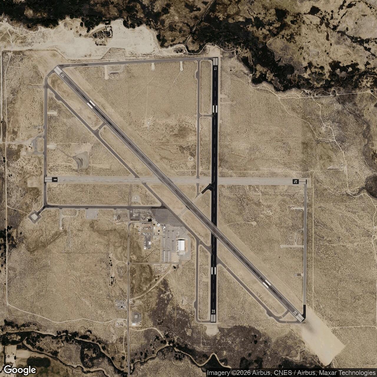
Bishop Airport's present physical plant preserves the most important physical legacy of the wartime field: long runways on an inland valley site. The current FAA-derived record lists three runways. Runway 12/30 is 7,498 by 100 feet. Runway 17/35 is 5,600 by 100 feet. Runway 8/26 is 5,567 by 100 feet. AirNav also records helicopter facilities, including H1 and H2. The 2002 airport master plan described the same three-runway system using then-current runway designations, with 12-30 as the primary runway and 16-34 and 7-25 as crosswind or secondary runways. The changed numbering reflects normal magnetic-heading updates over time rather than a different airport.
The field's layout is that of a civil airport enlarged for military utility and then retained for public aviation. The master plan describes an 831-acre site east of Bishop, leased for county operation. AirNav identifies the field as public, privately owned by the City of Los Angeles and operated through Inyo County. The airport's facilities include runways, taxiways, aprons, fueling, general aviation services, and associated airport buildings. Unlike many abandoned World War II airfields, Bishop did not disappear beneath agriculture, housing, or industrial reuse. It kept functioning as an airport, which means the runways themselves remain the most visible artifacts of the military period.
The military-era layout also reflected the training and storage mission. Bishop needed room for aircraft parking, service areas, personnel support, and the movement of aircraft associated with larger parent fields. Its inland location helped separate potentially hazardous aviation training from coastal population centers while still keeping it connected to a chain of western airfields. The physical setting also mattered. The airport sits in a valley where high terrain, weather, and elevation can be operational factors. That made the field valuable not simply as pavement, but as a training environment.
Role in the Wider Military Network
Bishop Army Air Field only makes full sense as part of the wartime western airfield network. The Army Air Forces did not build or lease each desert and valley field to operate in isolation. Fields were arranged as main bases, sub-bases, auxiliary landing fields, emergency fields, bombing and gunnery ranges, storage sites, ferrying points, and test-support locations. Bishop's place in that system was to support larger aviation missions in the eastern California and Nevada region while providing a capable inland runway complex in the Owens Valley.
That network role explains why Bishop's history is quieter than the histories of Muroc, Tonopah, or other famous western airfields, but still worth preserving. Muroc became a major test and training installation. Tonopah became a major bomber training field. Bishop supported the regional system by providing an additional tactical field, training site, storage location, and temporary support base. The 1943 Tonopah relocation episode is a particularly useful example because it shows the network working in real time. When one installation needed construction space, another field absorbed people and support activity.
Bishop also represents the wartime conversion of civil infrastructure into military capacity. The airport did not begin as a clean-sheet Army project. It began as a local airfield shaped by interwar civil aviation and county leasing arrangements. The Army then inserted that field into the national defense system. After the war, the same basic facility returned to local and regional aviation. That cycle was common across the United States, but Bishop's high-desert setting and survival as KBIH make the pattern unusually legible.
Closure, Civil Return, and Later Air Force Use
The Army's wartime lease did not become a permanent military reservation. Local airport history states that the Army canceled its lease with Inyo County in 1949 and that the airport was placed under civil control. That closure year is the best practical endpoint for Bishop as an Army Air Forces installation, even though the war had ended four years earlier and military drawdown began much sooner.
Civil reuse was not an afterthought. It was the airport's underlying identity. Inyo County continued to operate the field under lease arrangements, and the airport remained a regional aviation facility serving Bishop and the Eastern Sierra. General aviation, public-agency flights, search and rescue, firefighting, medical evacuation, charter aviation, and seasonal commercial service all fit naturally into a postwar airport that had retained long runways and an inland regional location.
Current Status
Bishop Airport, marketed in public-facing travel contexts as Eastern Sierra Regional Airport, remains an active public airport. AirNav identifies the field as BIH, with ICAO KBIH, two miles east of Bishop. The airport is publicly available, operated by Inyo County, and sits on land owned by the City of Los Angeles or its Department of Water and Power. Inyo County's airport page describes Bishop Airport as the gateway to the Eastern Sierra and links it to Mammoth, Bishop, Lone Pine, Independence, Big Pine, Death Valley, and Yosemite-area travel.
Current use reflects the airport's long-standing regional role. The field supports general aviation, visitor travel, private and charter aviation, public-agency operations, firefighting support, search and rescue, medical evacuation, and seasonal airline activity. The airport's long runways and open setting continue to give it more capability than many small regional airports. That capability is one reason military, federal, state, and emergency users have continued to appear there even after the formal Army field closed.
Chronology
- 1928-03-22 Local aviation history places the beginning of construction for the first Bishop airport on this date.
- 1929 The airport master plan states that the original lease agreement for Bishop Airport dates to 1929.
- 1939 Bishop and Lone Pine received Class 1 designations under the National Defense airport program, while Independence was identified as an emergency field.
- 1941 Inyo County received major federal support to improve Owens Valley airports to military specifications.
- 1941-12-07 The Japanese attack on Pearl Harbor and the entry of the United States into World War II increased demand for inland training fields in places such as the Owens Valley.
- 1942-06-10 Bishop Air Field was leased by the Army from Inyo County effective this date and designated a tactical military facility.
- 1942 Bishop Army Air Field entered wartime use as a training, storage, and support field within the Army Air Forces western aviation network.
- 1943-09 During major construction at Tonopah Army Airfield, roughly half of Tonopah's personnel were temporarily moved to Bishop Army Air Field, according to Tonopah aviation histories.
- 1943-11 Personnel temporarily relocated from Tonopah returned there as the construction pressure eased.
- 1944 Local Owens Valley aviation history links Bishop Army Air Field to Corsair landing or bounce training involving Marine pilots.
- 1945 The end of World War II reduced the Army Air Forces need for Bishop as a tactical and support field.
- 1949 The Army canceled its lease with Inyo County, and Bishop Airport returned to civil control.
- 1965-1985 The Air Force intermittently subleased runway and heliport areas for helicopter and aircraft performance testing, according to local airport history.
- 2002 The Bishop Airport Master Plan described the airport as an 831-acre site with three runways and continuing county operation under lease.
- Present Bishop Airport / Eastern Sierra Regional Airport remains an active public airport, FAA identifier BIH and ICAO KBIH, operated by Inyo County east of Bishop.