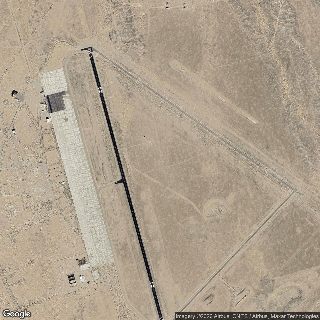
Tonopah Army Air Field, Tonopah Nevada
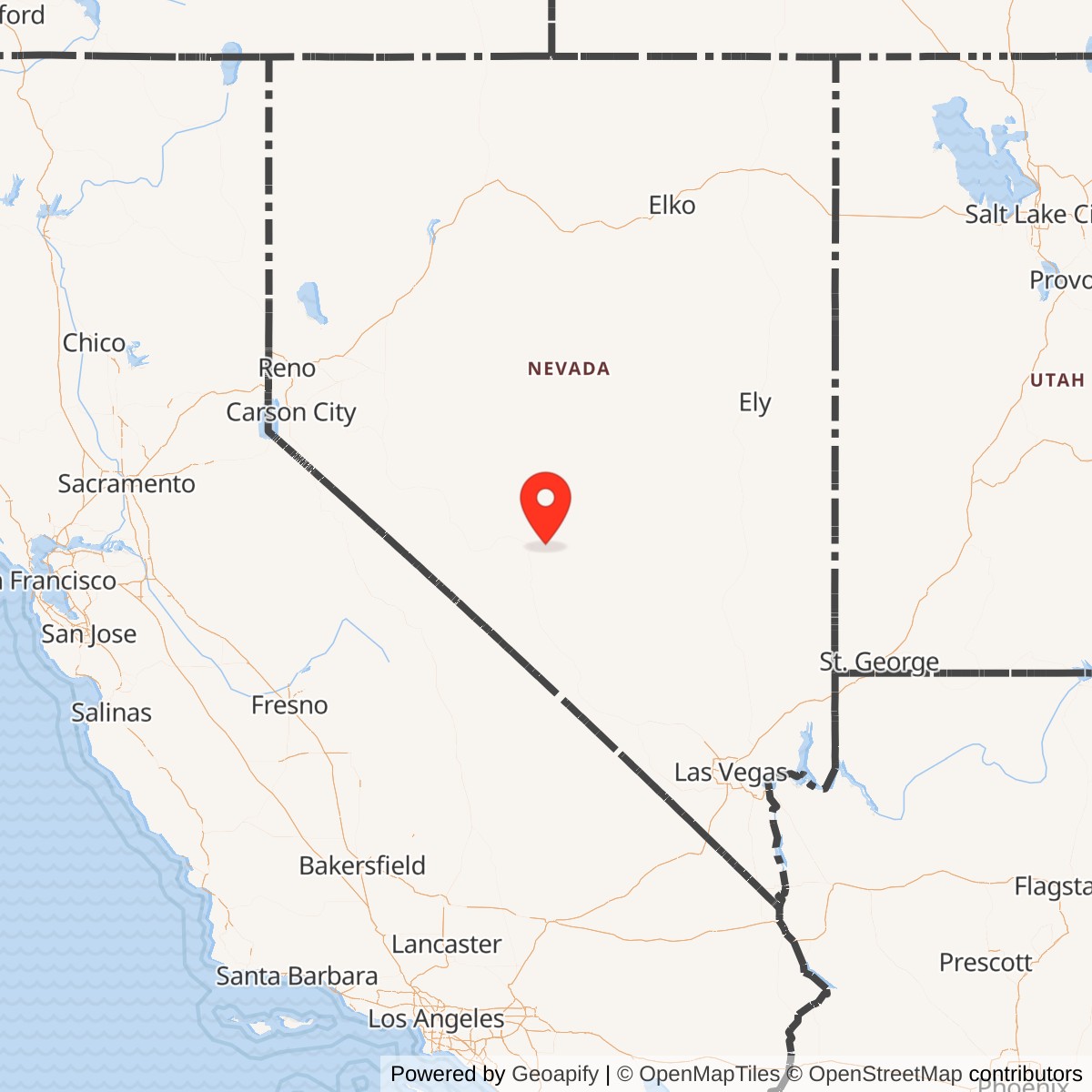
Longitude: -117.0866008
Airport ICAO ID: KTPH
Official Base Website: https://www.nyecountynv.gov/799/Tonopah-Airport
Current Role: Tonopah Airport, county-owned public-use airport; surviving or documented WWII-era hangars, bunkers, foundations, slabs, runways, airport operations, and brownfields/FUDS cleanup context.
Tonopah Army Air Field was a World War II Army Air Forces training base in central Nevada, built on an isolated high-desert airfield east of Tonopah and tied to an immense bombing and gunnery range that stretched across thousands of square miles of public land. It was not a permanent Regular Army post in the traditional sense. It was a wartime air-training installation, created to turn empty desert into a system for fighter training, bombardment training, B-24 heavy-bomber crew preparation, aerial gunnery practice, bombing practice, and specialized weapons testing.
The setting explains the field's importance. Tonopah stood far from the dense coastal and urban areas where flying safety, land acquisition, and public exposure limited training. The high desert offered wide clear airspace, sparse population, hard dry ground, and long visibility. At the same time, the town sat on U.S. highway routes and had a mining-era civic infrastructure that could support a surge of workers and military personnel. For the Army Air Forces, this made Tonopah a place where a complete air base and a massive range could be built quickly enough to serve the emergency expansion of air power after 1940.
The wartime military landscape had two related parts. The first was the airfield itself, with runways, hangars, barracks, mess halls, hospital facilities, administrative and operations buildings, warehouses, crash stations, utility systems, and later expanded aprons and support structures. The second was the larger range and auxiliary-field system around Tonopah, including bombing, gunnery, rifle, skeet, and navigation-training areas. The Nevada Division of Environmental Protection later summarized the former military property by noting that between 1941 and 1945 a total of 10,433 acres was transferred from the Department of the Interior to the U.S. Army for Tonopah Army Air Field, while the surrounding bombing and gunnery landscape was far larger.
Tonopah Army Air Field's military life was short but intense. The base became operational in 1942, shifted from fighter and mixed squadron training into B-24 Liberator crew training in 1943, supported replacement crew instruction through the end of the war, and was placed on inactive status in August 1945. Its active Army Air Forces training mission therefore lasted barely three years. During that time it became one of Nevada's largest wartime military operations and trained men and units for combat theaters overseas. It also left a postwar airport, an environmental and munitions-response record, surviving World War II-era hangars and foundations, and a direct connection to the later Nellis and Tonopah Test Range system.
Mission Evolution
The Tonopah mission began with land, airspace, and urgency. In September 1939, as the war in Europe widened after Germany's attack on Poland, General Headquarters Air Force at Langley Field was already considering whether Tonopah's existing aviation possibilities could be improved and whether a large nearby tract could be obtained for bombing and gunnery practice. The Army Air Forces needed training areas at a scale peacetime airfields could not provide. Western deserts, especially in Nevada, became central to that solution.
On October 29, 1940, more than three million acres of public land, roughly 5,000 square miles, were transferred from the Department of the Interior to the War Department for the Tonopah training range. Final land problems continued into 1941, but the strategic decision had already been made. Fourth Air Force would use the range to train combat units, and Tonopah would be the operating base. Construction on a new airfield seven miles east of town began in early 1940 under Civil Aeronautics Administration sponsorship, with Works Progress Administration funding involved and Army coordination built into the plan. This hybrid civil and military origin is important: Tonopah's airfield began as part of federal airport improvement and employment policy, but it was quickly absorbed into wartime air training.
The base was not ready for occupancy until July 1942. When the Army finally occupied it, the field already had the essentials of a wartime air base: runways, barracks, mess halls, hospital facilities, and other support structures. Ordnance, guard, quartermaster, supply, signal, weather, communications, finance, and other service elements moved in to make the place work. The first aircraft were Bell P-39 Airacobras, and by the beginning of 1943 the base had 227 officers and 1,779 enlisted men.
The first operational phase was mixed bombardment and fighter training. Tonopah hosted the 75th and 390th Bombardment Squadrons of the 42nd Bombardment Group, then squadrons of the 354th Fighter Group. Three 354th squadrons, the 255th, 353rd, and 356th, arrived on January 18, 1943. They were followed in March by squadrons of the 357th Fighter Group. By the end of November 1943, eight bombardment squadrons and twelve fighter squadrons had used the base to train for combat overseas. This early tempo shows that Tonopah was not an empty desert experiment. It was quickly integrated into the personnel pipeline that fed air combat organizations.
That first phase also revealed the limits of the site. The P-39 Airacobra was not an easy aircraft in Tonopah conditions. The base operated at high elevation, the desert produced difficult weather and density-altitude conditions, and Central Nevada Museum's history notes that planes and pilots were being lost in crashes at an unacceptable rate. Tonopah's very advantages, distance, isolation, and rugged training terrain, also made flying unforgiving. The Army therefore changed the mission rather than abandon the installation.
The decisive shift came in September 1943, when Tonopah was converted into a high-altitude B-24 Liberator bomber training base. About half the personnel moved temporarily to Bishop Army Air Field in California so contractors could carry out a major expansion program. The $3 million project extended runways, added aprons, expanded water storage, built more quarters and barracks, added a post exchange, supply buildings, day rooms, crash stations, warehouses, operations buildings, a hangar, a school building, and improved the range. By the beginning of November 1943, most of the expansion was complete, and Tonopah was ready for its mature role as a heavy-bomber crew training base.
The B-24 phase dominated the rest of the war. On November 1, 1943, the personnel who had temporarily moved to Bishop returned, and the 458th Bombardment Group arrived for training. When the 458th left in early January 1944, the 470th Bombardment Group arrived to serve as a replacement training unit for B-24 crews. On March 31, 1944, the 470th was disbanded and its training functions passed to the 442nd Army Air Force Base Unit. From that point forward, the base's central mission was replacement crew training for B-24 operations. In October 1944, Tonopah had 66 B-24 aircraft available for the training program and had 1,264 officers and 5,273 enlisted men assigned, plus a large civilian workforce.
Tonopah also developed a specialized test role. In summer 1944, a Field Test Unit from the special weapons test organization at Wright Field, Ohio, used the base and range to test glide bombs and other devices. This did not replace B-24 training, but it shows how Tonopah's large range, isolated airspace, and instrumentation potential made it useful beyond ordinary crew instruction. In miniature, the wartime field foreshadowed the later pattern of central Nevada military use: large restricted landscapes, advanced weapons work, desert targets, and a close relationship between aircraft, ranges, and test organizations.
Operational Role
Tonopah Army Air Field's operational role was to make air combat possible by absorbing units, crews, aircraft, and support personnel and pushing them through the last stages of preparation for war. A pilot or crewman who passed through Tonopah was not simply attending a classroom. He was operating at altitude, in desert weather, on long runways, over bombing targets, through gunnery exercises, and inside a military city built almost overnight.
The early fighter phase trained units that later became part of the American air war overseas. The 354th Fighter Group's squadrons used Tonopah in January and early 1943, and squadrons of the 357th Fighter Group followed in March. The 357th later became one of the well-known Eighth Air Force fighter groups in Europe after conversion to P-51 Mustangs, but its early P-39 training phase passed through Tonopah. Tonopah's contribution to these fighter groups was not glorious in the way later European combat was. It was harsher and more basic: learning aircraft, formation work, gunnery routines, navigation, maintenance rhythms, and the realities of flying from a remote desert base.
The safety cost was high. Central Nevada Museum's commemorative material lists 110 Army Air Force men who lost their lives in accidents related to Tonopah Army Air Field operations between 1942 and 1945, with most killed in P-39 and B-24 crashes. Those losses are central to the field's history. Wartime air training was dangerous everywhere, and at Tonopah the combination of high elevation, training pressure, mechanical demands, and bomber and fighter operations made the base deadly even before crews reached combat. The site's history is therefore not only about successful mobilization. It is also about the human cost of learning modern air war at wartime speed.
The B-24 mission gave Tonopah its mature operational identity. The Liberator was a four-engine heavy bomber with long range and a large crew, and training replacement crews required far more than flying circuits. Tonopah provided bombing practice, aerial gunnery, navigation, radio, turret, bombing, and crew-coordination training. The training equipment and areas included rifle and pistol ranges, skeet ranges, turret trainers, bomb trainers equipped with Norden or Sperry sights, flexible-gunnery trainers, navigation trainers, and schools for gunners and radio operators. The surrounding range allowed actual bombing and aerial gunnery practice. This was a complete training ecosystem, not merely a runway.
The 458th Bombardment Group's arrival in November 1943 marks Tonopah's move into full heavy-bomber work. The group trained at the base before departing in early January 1944. The 470th Bombardment Group followed as a replacement-training organization, and then the 442nd Army Air Force Base Unit took over those functions. Through 1944 and 1945, individual replacement crews and airmen passed through the base for B-24 instruction before assignment to overseas heavy-bomber units. A replacement-training base had a different rhythm than a unit activation base. It did not simply assemble one group and send it overseas. It repeatedly processed crews, instructors, aircraft, maintenance demands, and support systems to feed a continuing combat pipeline.
The base's size produced a full garrison life. Tonopah had one of the largest post exchanges in Fourth Air Force, a major bakery and doughnut shop, theaters, recreation facilities, and all the routine services needed for thousands of personnel living in the desert. In October 1944, the assigned strength of 1,264 officers and 5,273 enlisted men put the uniformed population at more than 6,500 before civilians are counted. In a remote Nevada community, that was a major temporary city. It changed Tonopah's economy, roads, housing, labor market, and daily life during the war.
The Field Test Unit's glide-bomb work added a weapons-development element. A large bombing range, an airfield with heavy-bomber capacity, and an isolated desert environment made Tonopah useful for experimenting with devices that could not be tested easily near populated areas. The base thus bridged training and testing. That relationship was not accidental. Wartime air power required proving grounds as well as schools, and Tonopah offered both.
Units, Organizations, and Systems
Tonopah Army Air Field was principally a Fourth Air Force installation. Its mission was tied to the West Coast and inland-west Army Air Forces training system that included major bases in California, Nevada, Idaho, and elsewhere. At various times the field was a sub-base linked to March Field, Hamilton Field, and later Castle Field, reflecting the administrative reshuffling common to wartime and immediate postwar air installations.
The first organization associated with the wartime base was the Bombing and Gunnery Range Detachment from Muroc Lake, California, which arrived as the field was being occupied in July 1942. This unit's presence illustrates the range-centered origin of the installation. Tonopah was never only an airport. It was an airfield attached to an enormous training landscape.
The early tactical users included the 75th and 390th Bombardment Squadrons of the 42nd Bombardment Group. They were followed by the 255th, 353rd, and 356th Fighter Squadrons of the 354th Fighter Group, which arrived in January 1943. Squadrons of the 357th Fighter Group followed in March 1943. By late 1943, the base had aided the training of eight bombardment squadrons and twelve fighter squadrons. These organizations tie Tonopah directly to the Army Air Forces' rapid expansion of deployable combat units.
The heavy-bomber phase centered on the 458th Bombardment Group, the 470th Bombardment Group, and the 442nd Army Air Force Base Unit. The 458th arrived for B-24 training on November 1, 1943. The 470th then served as a replacement training unit for B-24 crews until it was disbanded on March 31, 1944. The 442nd Army Air Force Base Unit then assumed the training function and remained the central operating organization until it was discontinued on October 15, 1945.
The support system was equally important. Ordnance, quartermaster, guard, supply, signal, weather, communications, finance, maintenance, crash, medical, transportation, and administrative functions kept the base operational. These units and sections were not secondary details. B-24 training depended on fuel, ammunition, bomb storage, engine maintenance, weather forecasting, runway repair, medical response, fire and crash crews, radio systems, and specialized school equipment. The aircrews may have been the visible product of the field, but the installation worked because support units could sustain a heavy technical mission in a remote desert environment.
The special weapons Field Test Unit from Wright Field represents another system connection. Wright Field was the Army Air Forces' major engineering and test center, and its use of Tonopah for glide-bomb testing shows that the field had value to the technical-development side of the service. Tonopah therefore sat at the intersection of three systems: combat-crew training, bombing and gunnery range operation, and experimental weapons testing.
Facilities and Physical Layout
The physical layout of Tonopah Army Air Field reflected its desert training mission. The main airfield lay east of Tonopah along what is now the public airport corridor. Its runways and aprons were the heart of the installation, but the wartime base included far more than pavement. It had barracks, mess halls, a hospital, theaters, a stockade, a gymnasium, maintenance buildings, hangars, warehouses, crash stations, operations buildings, school buildings, supply buildings, day rooms, post exchange facilities, water storage, utilities, and roads.
The 1943 expansion made the airfield capable of sustained B-24 operations. Heavy bombers required longer and stronger runways, larger parking aprons, more maintenance capacity, fuel storage, training buildings, and broader crash and fire-response capacity. The $3 million project in fall 1943 therefore changed the field's character. What had been a mixed fighter and bombardment training post became a high-altitude heavy-bomber training base.
The training landscape extended beyond the main airfield. Tonopah's ranges included bombing and aerial gunnery areas, plus rifle, pistol, skeet, turret, navigation, gunnery, and radio-operator training facilities. Auxiliary landing fields and bombing targets supported operations across a huge region. The main field was the administrative and technical hub. The range was the combat-training space.
Current Tonopah Airport preserves part of that layout. AirNav identifies Tonopah Airport, FAA identifier TPH, as a public-use Nye County airport, seven miles east of Tonopah, with an elevation of 5,430.3 feet. The airport has Runway 15/33 at 7,160 by 75 feet and Runway 11/29 at 5,660 by 50 feet. These current runways reflect continued aviation use on the former military airfield footprint. NDEP and brownfields documentation also identify surviving or formerly documented World War II-era features, including original 1940s hangars, bunkers, building remnants, and foundation slabs.
The site also contains environmental and infrastructure legacies. NDEP's Tonopah Airport fact sheet notes former underground storage tanks, oil pits, maintenance sites, ordnance operations locations, paint, oil and dope storage areas, former chemical-warfare operations and material storage areas, asbestos concerns at building sites, and a former landfill. These features are typical of a fast-built World War II air base, where fuel, solvents, paints, munitions, petroleum handling, vehicle maintenance, and temporary construction left postwar cleanup responsibilities.
Role in the Wider Military Network
Tonopah Army Air Field belonged to the larger Army Air Forces training network that transformed civilian pilots and new airmen into combat crews. In that network, fields were not interchangeable. Some specialized in primary flight training, some in advanced aircraft transition, some in gunnery, some in bombardment, and some in heavy-bomber crew preparation. Tonopah's role evolved from fighter and bombardment squadron training into B-24 replacement crew training because the desert range, expanded runways, and high-altitude environment made it especially suited to that mission.
It also formed part of Nevada's wartime military transformation. Las Vegas Army Air Field, Indian Springs, Tonopah, and the Tonopah and Las Vegas Bombing and Gunnery Ranges turned southern and central Nevada into one of the country's major aerial training landscapes. Sparse population was not incidental. It was the strategic resource. The Army could place targets, fly gunnery missions, test weapons, and train at scale because the federal government controlled large areas of desert and because the risk to civilian populations was comparatively low.
The Tonopah range also became part of the postwar military geography of Nevada. Sandia's Tonopah Test Range environmental history notes that after Tonopah Army Air Field was placed on inactive status in August 1945 and later declared excess, the airfield was turned over to Tonopah as Tonopah Airport, while the test and training space to the southeast was incorporated into Nellis Air Force Base. In the 1950s, the Cactus Flats area of that larger range region became the Tonopah Test Range for Sandia and Atomic Energy Commission work. The World War II field itself did not become the Cold War Tonopah Test Range airfield, but the wartime decision to militarize the Tonopah desert helped create the range architecture that later supported Cold War weapons testing and classified aviation.
That longer system context is essential. Tonopah Army Air Field's direct Army Air Forces mission ended soon after World War II, but the broader range logic survived. Nevada's empty airspace, federal land, remote dry lakebeds, and long sight lines remained valuable. Tonopah's wartime base was one early expression of a military geography that later included Nellis, Indian Springs, the Nevada Test Site, Sandia's Tonopah Test Range, and specialized Air Force testing.
Closure and Postwar Reuse
The war ended before Tonopah's B-24 mission could become permanent. By March 1945, War Department pressure to reduce manpower had already cut the base population to 437 officers, 3,707 enlisted men, and 184 civilians. On August 23, 1945, a little over a week after fighting ended in the Pacific, Fourth Air Force placed Tonopah Army Air Field on inactive status. Personnel and aircraft began leaving almost immediately.
On October 15, 1945, the 442nd Army Air Force Base Unit was discontinued, and the field became a sub-base of Hamilton Field, California. The base passed through additional postwar administrative arrangements and was declared excess in 1947. The airfield was later transferred from federal military use, and by 1949 ownership had passed to Nye County. The county operated the former military field as Tonopah Airport.
The postwar disposal process turned much of the air base into scrap, salvage, airport infrastructure, and later civilian reuse. Some buildings disappeared, some foundations remained, and some original hangars survived in various states of repair. The NDEP brownfields record notes that the Tonopah Airport property was used primarily as a municipal airport and that later development included airport operations, commercial and military aviation activity, a residential subdivision, an oil refinery, a sand and gravel quarry, a race track, and public works infrastructure. That layered reuse is typical of former World War II airfields. They rarely remained frozen in their 1945 form. Instead, runways, hangars, roads, utilities, and open land were adapted to local needs.
Environmental review became part of the later story. The U.S. Army Corps of Engineers identified Tonopah Army Airfield as a Formerly Used Defense Site, property number J09NV0969, with project categories including containerized hazardous, toxic, or radioactive waste, hazardous toxic or radioactive waste, and military munitions response. Separate entries also identify Tonopah Army Airfield Practice Bombing Ranges and Tonopah Rifle Range. NDEP's fact sheet records USACE removal of underground storage tanks and oil pits in 1998, a preliminary assessment in 2000, subsequent site investigation, and remediation actions at selected locations. The field therefore continued to carry Army responsibilities long after the aircraft left.
Current Status
Tonopah Army Air Field is closed as a U.S. Army Air Forces installation. The airfield core is now Tonopah Airport, a public-use airport owned by Nye County. The county's airport page lists Tonopah Airport at 101 Radar Road, and AirNav identifies it as FAA identifier TPH, open to the public, with Nye County as owner. Current airport facilities include two asphalt runways, fuel service, tiedown and ramp parking, aviation services, and instrument procedures.
The airport remains historically legible. The current runways sit on the former military airfield, and brownfields documentation identifies original 1940s hangars, original bunkers, building remnants, and foundation slabs on the airport property. The exact survival and condition of individual wartime structures vary, and some areas are operational or restricted airport property rather than open historic sites. Still, the relationship between the World War II base and current airport is unusually direct. This is not a former airfield buried under a subdivision. It remains an aviation landscape.
The present site should not be confused with Tonopah Test Range Airport, which is a separate active Air Force installation southeast of Tonopah on the Tonopah Test Range. The former Tonopah Army Air Field is the current public Tonopah Airport east of town. The Tonopah Test Range and its airport are part of a different Cold War and modern test-range system, though their location and origins are connected to the broader wartime and postwar military use of the Tonopah desert.
Chronology
- 1939-09 - Within weeks of Germany's attack on Poland, General Headquarters Air Force began considering the improvement of Tonopah's airdrome and acquisition of nearby land for bombing and gunnery practice.
- 1940-10-29 - More than three million acres of public land near Tonopah were transferred from the Department of the Interior to the War Department for bombing and gunnery range use.
- 1941 - Final land problems were resolved through condemnation proceedings, and the airfield and range plan moved toward wartime use.
- 1941-1945 - A total of 10,433 acres was transferred from the Department of the Interior to the U.S. Army for the Tonopah Army Air Field property.
- 1942-07 - Tonopah Army Air Field became ready for occupancy and military personnel began occupying the base.
- 1942 - The Bombing and Gunnery Range Detachment from Muroc Lake, California, arrived as one of the first operating organizations.
- 1942-08 - The post exchange opened and later became one of the largest in Fourth Air Force.
- 1943-01 - By the beginning of the year, Tonopah had 227 officers and 1,779 enlisted men.
- 1943-01-18 - The 255th, 353rd, and 356th Fighter Squadrons of the 354th Fighter Group arrived at Tonopah.
- 1943-03 - Squadrons of the 357th Fighter Group replaced the departing 354th Fighter Group squadrons.
- 1943-09 - Tonopah shifted toward a high-altitude B-24 Liberator bomber-training mission; about half of the personnel moved temporarily to Bishop Army Air Field during major construction.
- 1943-11 - Most of the $3 million airfield expansion was complete, including runway, apron, water, housing, operations, hangar, and range improvements.
- 1943-11-01 - The 458th Bombardment Group arrived at Tonopah for B-24 training.
- 1943-11 - By the end of the month, eight bombardment squadrons and twelve fighter squadrons had used the base to train for overseas combat.
- 1944-01 - The 458th Bombardment Group departed, and the 470th Bombardment Group arrived to serve as a replacement training unit for B-24 crews.
- 1944-03-31 - The 470th Bombardment Group was disbanded, and its training functions were taken over by the 442nd Army Air Force Base Unit.
- 1944 Summer - A Field Test Unit from the special weapons test organization at Wright Field used Tonopah to test glide bombs and other devices.
- 1944-10 - Tonopah had 66 B-24 aircraft available for the training program, with 1,264 officers and 5,273 enlisted men assigned.
- 1945-03 - Base strength had been reduced to 437 officers, 3,707 enlisted men, and 184 civilians.
- 1945-08-23 - Fourth Air Force placed Tonopah Army Air Field on inactive status.
- 1945-10-15 - The 442nd Army Air Force Base Unit was discontinued, and the field became a sub-base of Hamilton Field, California.
- 1947 - Tonopah Army Air Field was declared excess.
- 1948 - The former base was deactivated and sold for scrap while under postwar Air Force jurisdiction.
- 1949 - Ownership of the land was transferred to Nye County, and the former military field entered long-term use as Tonopah Airport.
- 1998 - USACE removed eleven concrete underground storage tanks, five metal underground storage tanks, and four concrete oil pits from the former airfield.
- 2000 - USACE conducted a preliminary assessment of the former Tonopah Army Air Field to determine whether further environmental action was needed.
- 2004 - NDEP prepared a draft decision document for the former Tonopah Army Airfield FUDS investigation.
- 2014 - Environmental assessment and brownfields planning addressed the former airport operations / FBO building area and related environmental issues.
- Present - The former Tonopah Army Air Field is closed as a military installation and operates as Nye County's public Tonopah Airport, while its former military history remains visible in surviving runways, hangars, foundations, bunkers, FUDS records, and local museum interpretation.