
Otis Air Force Base / Otis Air National Guard Base, Massachusetts
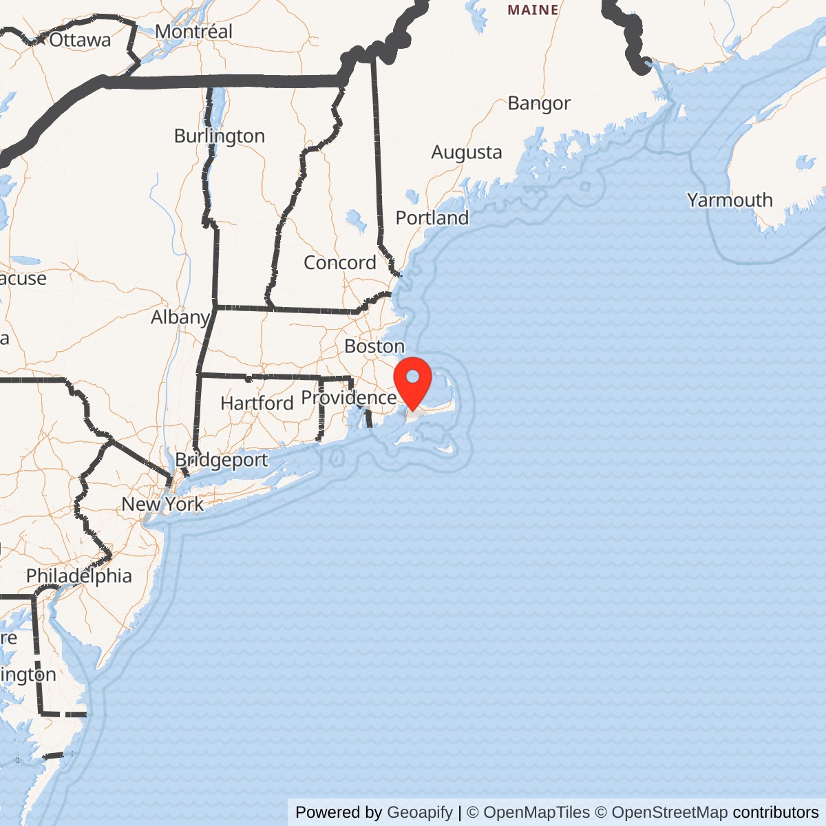
Longitude: -70.521389
Airport ICAO ID: KFMH
Official Base Website: Otis Air National Guard Base / Joint Base Cape Cod
Current Role: Active Otis Air National Guard Base within Joint Base Cape Cod. The 102nd Intelligence Wing provides precision intelligence, command and control, expeditionary support, and homeland-security capabilities. The 253rd Cyberspace Engineering Installation Group supports worldwide communications, cable, antenna, radar, airfield, and weather-system engineering. The Coast Guard operates the shared KFMH airfield and Coast Guard Base Cape Cod. Current Air Guard support extends to multiple joint-base tenants.
Otis Air Force Base, now Otis Air National Guard Base, is the principal military aviation installation within Joint Base Cape Cod in Barnstable County, Massachusetts. Its history reaches from a 1930s Massachusetts National Guard flying field through World War II patrol and training missions, postwar Air Defense Command fighter and radar operations, airborne early warning, Texas Tower support, BOMARC missile defense, and an Air National Guard fighter mission. Since 2008, its central Air Force mission has been intelligence, command and control, cyberspace engineering, expeditionary support, and homeland defense rather than operation of an assigned fighter wing.
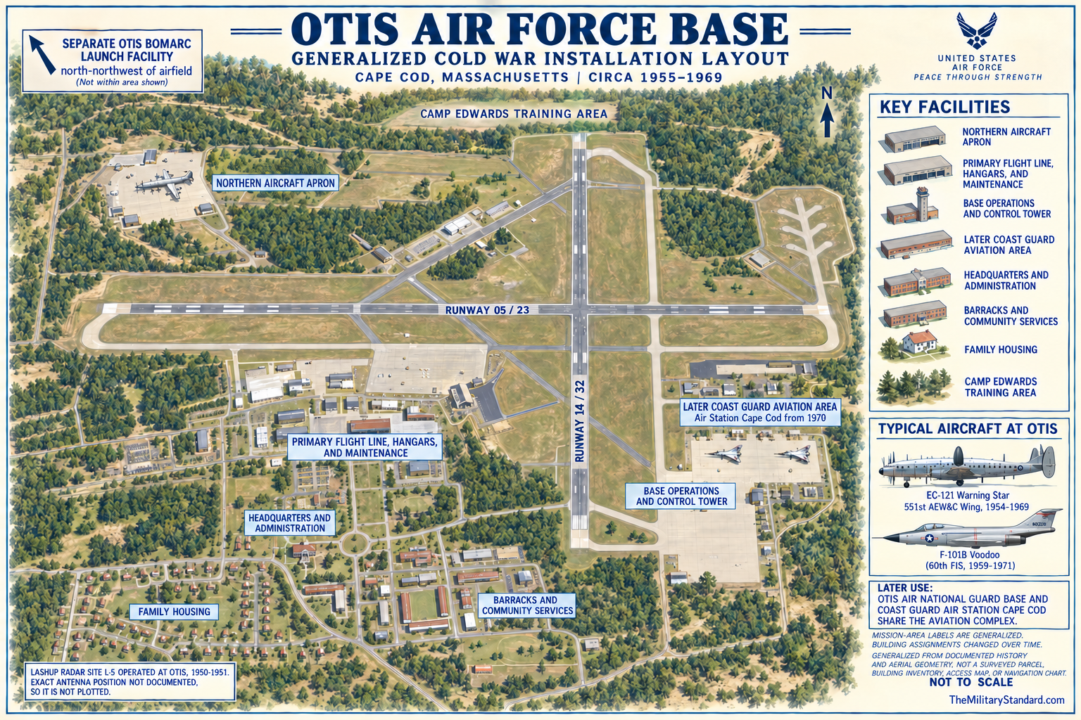
The installation is not synonymous with the entire former Massachusetts Military Reservation or present Joint Base Cape Cod. Camp Edwards is a distinct Army installation occupying most of the northern training area. Coast Guard Air Station Cape Cod and Base Cape Cod occupy and operate important parts of the aviation complex. Cape Cod Space Force Station is a separate 100.5-acre early-warning radar installation on Flatrock Hill. The former Otis BOMARC Missile Launch Facility was a separately located Air Force missile complex north-northwest of the airfield. Treating every activity on the reservation as Otis would obscure real boundaries, missions, chains of command, and environmental responsibilities.
Otis was one of the most consequential continental air-defense bases in New England. It hosted interceptor organizations, the 551st Airborne Early Warning and Control Wing and its radar picket aircraft, a temporary Lashup radar designated L-5, support organizations for the offshore Texas Towers, and the administrative and logistical base for a BOMARC surface-to-air missile squadron. Its aircraft and crews watched Atlantic approaches, supported the SAGE system, tracked Soviet reconnaissance aircraft, and later maintained alert for the northeastern United States. The base linked ground radar, airborne radar, fighter aircraft, missiles, communications, and command posts into a layered defensive network.
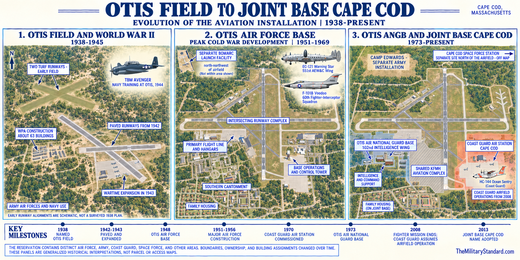
The installation also illustrates repeated reuse rather than a simple opening and closure. The Army and National Guard developed the field, the Army Air Forces expanded it in World War II, the independent Air Force established Otis Air Force Base in 1948, and Air Defense Command made it a large active-duty complex. In 1973 the aviation installation became Otis Air National Guard Base, but flying and air-defense missions continued. The Coast Guard assumed responsibility for airfield operations in October 2008, while the Massachusetts Air National Guard retained an active installation and transformed the 102nd Fighter Wing into the 102nd Intelligence Wing.
Identity, Names, and Boundaries
The field was named for First Lieutenant Frank Jesse Otis, a Massachusetts National Guard aviator of the 101st Observation Squadron who died after an aircraft accident on January 11, 1937. Official histories commonly call him Frank "Jesse" Otis. The landing field received the name Otis Field in 1938, and the Air Force installation became Otis Air Force Base in 1948. Otis Air National Guard Base became the formal designation in 1973. These names describe successive phases at the same aviation site, while Massachusetts Military Reservation and Joint Base Cape Cod describe the larger multi-installation reservation.
Joint Base Cape Cod extends across parts of Bourne, Falmouth, Mashpee, and Sandwich, and official sources use all four communities when describing the reservation. The airfield lies in the southern cantonment area, with facilities spread across municipal boundaries and mailing addresses that do not define ownership.
The original airfield and later base grew through multiple land and jurisdictional actions. A 1930s state and federal works program built the National Guard field within the military reservation. Wartime construction added permanent runways and facilities. Congress authorized transfer of the military airfield and much of the main-post area from the Army to the Air Force in 1954, while the Army retained training ranges. Later redistribution created Air Guard, Army, Coast Guard, federal cemetery, and radar holdings. No single published acreage represents Otis through every period, and current functional control does not necessarily match historic fee ownership.
Current sources describe Joint Base Cape Cod as approximately 21,600 or 22,000 acres. An official Coast Guard environmental manual assigns about 3,586 acres to Coast Guard responsibility and about 14,700 acres to Army responsibility, while an Air Force environmental memorandum describes a roughly 15,000-acre northern range, a roughly 7,000-acre cantonment, a 750-acre national cemetery, and a 100-acre Cape Cod radar station. These numbers use different dates and functional definitions and may overlap. They are valuable for joint-base context, but none can be entered as the acreage of Otis Air National Guard Base.
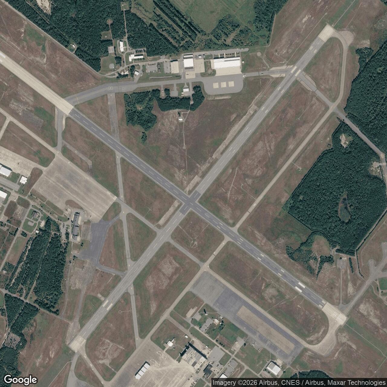
The airfield identifier KFMH also requires qualification. It identifies the joint-use military airfield historically associated with Otis, not an Air Force-only civil airport. The Federal Aviation Administration identifier FMH and ICAO identifier KFMH continue in aviation use, while the Coast Guard has operated and maintained the airfield since October 2008. Runways, lighting, the control tower, weather support, navigation aids, and snow removal serve multiple military users.
National Guard Origins and New Deal Construction
The Massachusetts National Guard established an aviation tradition well before Otis Field. The 101st Observation Squadron was organized in 1921 and operated from the Boston area, where it trained for reconnaissance, artillery adjustment, liaison, and support of ground forces. The need for a larger training location joined with development of the Massachusetts Military Reservation on Cape Cod in the 1930s. The new field gave the Guard room for flying, encampments, and combined training away from the congested metropolitan airport environment.
Between 1935 and 1940, Commonwealth, federal, and Works Progress Administration labor developed the reservation and airfield. The official Camp Edwards history credits more than 600 workers and calls the program the largest WPA project in Massachusetts. Approximately 63 buildings and two turf runways, each about 500 feet wide, formed the early field. This was substantial public infrastructure, not a temporary cleared strip. Roads, utilities, drainage, administration, storage, and living support allowed the field to become a durable military aviation installation.
Camp Edwards was dedicated in July 1938, and the airfield was named Otis Field that year. The naming connected the new physical plant to a specific Massachusetts National Guard airman and to the 101st Observation Squadron. Sources differ on when the 101st moved from the Boston area to Otis. The 102nd Intelligence Wing history places the move in 1940, while the Massachusetts National Guard history says 1941. The record supports a 1940-1941 transition, and this history preserves that discrepancy rather than forcing an unsupported exact date.
The prewar field occupied a strategic Cape Cod position. Aircraft based there could reach the Atlantic approaches, Cape Cod Canal, coastal shipping lanes, and southern New England. The same geography exposed operations to fog, salt air, winter storms, and strong coastal winds, all of which shaped runway, hangar, navigation, rescue, and maintenance requirements. Otis began as a Guard training field, but its location gave it immediate relevance when German submarines and the possibility of hostile action brought the Atlantic war close to the American coast.
World War II Service
After federal mobilization, the Army expanded Otis for wartime operations. Concrete runways replaced or supplemented the turf surfaces in 1942, and the runways were lengthened and widened in 1943. Hangars, aprons, barracks, shops, warehouses, communications, fuel systems, and administrative buildings converted the field into a large wartime base. These improvements established the durable runway geometry and cantonment pattern from which the postwar Air Force complex grew, although later construction repeatedly altered individual facilities.
The 14th Antisubmarine Patrol Squadron operated from Otis during 1941-1943 as the United States organized aerial protection of coastal waters. Crews searched for submarines, escorted or covered shipping, reported suspicious activity, and helped close the reconnaissance gap off New England. The mission demanded long overwater flights, weather judgment, navigation, radio discipline, and rapid maintenance. It also connected Otis to Navy, Coast Guard, civil maritime, and Army command networks rather than limiting the field to local training.
Responsibility for offshore antisubmarine aviation shifted as the Navy consolidated the mission. Official Massachusetts Guard history states that the Navy assumed reconnaissance responsibility in 1944 and used the field during the last two wartime years, including training related to carrier operations. This phase added a naval dimension to Otis without changing the underlying Army ownership of the field. It also foreshadowed the later multi-service character of the Cape Cod reservation and the Coast Guard's eventual role as airfield operator.
Wartime Otis supported training and staging beyond antisubmarine patrol. Observation, fighter, support, and transient aircraft used the field, while Camp Edwards trained large ground formations nearby. The airfield and camp shared roads, utilities, medical support, housing, and a labor force, yet their operational purposes remained distinguishable. Aircraft activity served continental defense and force preparation; Camp Edwards provided maneuver, weapons, and unit training. The modern registry preserves that distinction by retaining Camp Edwards as an Army installation and Otis as an Air Force installation.
At the end of the war, military demand contracted quickly. Camp Edwards and Otis entered inactive or caretaker conditions in 1946, but the airfield was not abandoned. A runway was extended to 8,000 feet, and Massachusetts National Guard aviation returned. The 101st was reactivated in the postwar Guard on July 29, 1946. These actions created continuity between the wartime field and the permanent Air Force base established two years later, while also showing why a single opening date cannot describe every phase of the site.
Establishment of Otis Air Force Base
The United States Air Force assumed control of the aviation installation in 1948 and designated Otis Air Force Base. The new service needed fighter bases from which Air Defense Command could protect Boston, southern New England, the Atlantic approaches, and the industrial and military complex of the Northeast. Otis combined long runways, coastal access, available reservation land, and room for radar, command, maintenance, and housing.
The 33d Fighter Wing moved to Otis in 1948 and became a central early interceptor organization. Its squadrons included the 58th, 59th, and 60th Fighter Squadrons during portions of the postwar period. Aircraft and designations changed as piston fighters gave way to jets and as day-fighter organizations became all-weather interceptor units. The 60th Fighter Squadron arrived on November 16, 1948, moved to Westover in August 1950, returned to Otis on August 18, 1955, and later became the first Air Defense Command squadron equipped with the F-101B in 1959.
The Korean War emergency accelerated expansion. Camp Edwards reactivated in 1950, Air Force construction spread across much of the main post, and Otis added hangars, alert facilities, shops, barracks, family housing, utilities, warehouses, and command buildings. Official reservation history places a major wave of Air Force construction between 1951 and 1956, especially south of the airfield. The result was not merely an airfield with a few squadrons, but a large, self-contained active-duty base capable of sustaining aircraft, radar, missile, communications, and support missions.
Congressional transfer in 1954 formalized the Air Force position. The military airfield and much of the main-post area passed from Army to Air Force jurisdiction, while the Army retained the northern ranges needed for Camp Edwards training. This division shaped later land-management problems because roads, utilities, housing, and environmental systems continued to cross organizational lines. The transfer also helps explain why sources sometimes call broad cantonment facilities Otis even when their later owners or operators were Army, Coast Guard, or another federal agency.
Interceptor and Air Defense Operations
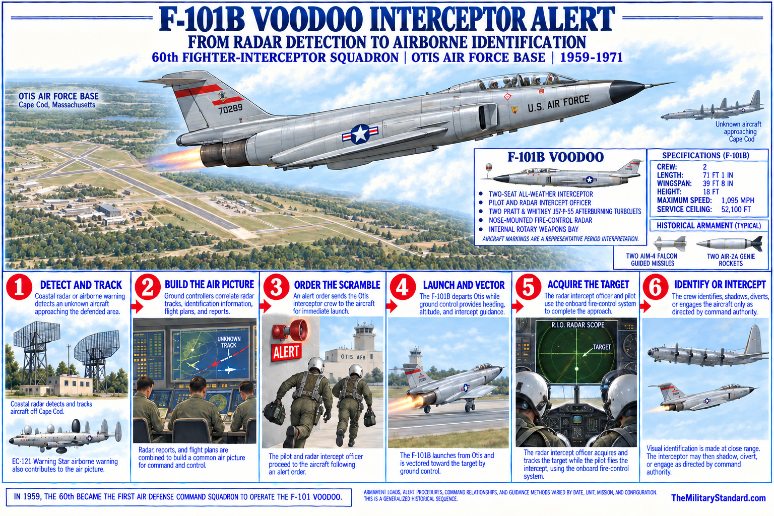
Otis interceptor units formed a ready response to unidentified aircraft approaching New England. Radar stations reported tracks, command centers evaluated them, and fighters launched to identify or intercept targets. All-weather operations required radar-equipped aircraft, trained controllers, alert crews, weapons teams, fuel, rescue, fire protection, and maintenance available around the clock. The base's coastal location shortened the route to offshore tracks and permitted interceptions before unknown aircraft reached the densely populated corridor from Boston to New York.
The 33d organization changed repeatedly as Air Defense Command reorganized. The 33d Fighter-Interceptor Wing and later 33d Air Defense Group periods included the 58th, 59th, and 60th fighter-interceptor lineages, while the 4707th Defense Wing and other higher headquarters administered the expanding defense force. Project Arrow restored historic fighter-group designations in August 1955, bringing the 33d Fighter Group back into the Otis structure. Unit dates must therefore be read as lineage and assignment changes, not as repeated opening or closure of the installation.
Aircraft at Otis traced the technical evolution of interception. Early postwar types gave way to the F-86D and F-94 all-weather interceptors and then to the supersonic F-101B Voodoo. The F-101 carried radar, missiles, and a two-person crew for rapid interception under ground or SAGE control. The 60th Fighter-Interceptor Squadron's 1959 conversion marked the first operational use of the F-101B within Air Defense Command. Other units and transient deployments contributed additional aircraft, so no single type represents the whole active-duty era.
Interceptor alert shaped the base physically. Hardened or protected alert areas near runway ends reduced launch time. Weapons-storage and maintenance facilities supported guided missiles and rockets. Radar and communications buildings connected the flight line to regional command networks. Fire stations, arresting equipment, crash rescue, medical support, and weather services protected continuous operations. Family housing, schools, recreation, a hospital, commissary, exchange, chapel, and clubs supported a large permanent community whose daily life was inseparable from the alert mission.
Lashup Radar Site L-5
Otis also hosted a temporary Air Defense Command radar function designated Lashup site L-5. The ADC historical data record lists L-5 as operational in July 1950 with AN/CPS-5 search radar and AN/TPS-10A height-finding equipment. Lashup sites used available radar sets to provide interim warning while the permanent network was being designed and built.
ADC records place L-5 inactivation in October 1951 and identify North Truro P-10 as its successor. North Truro occupied a separate site near the outer Cape and received its own squadron, permanent radar plant, housing, utilities, and later SAGE and Joint Surveillance System missions. The change therefore represented geographic and organizational replacement, not a renaming of the Otis radar. Otis retained fighter, airborne early warning, command, and support functions after its temporary ground radar closed.
The Lashup equipment record is specific but limited. AN/CPS-5 supplied search coverage, while AN/TPS-10A supplied height data. The historical compilation does not establish the precise antenna coordinates, buildings used, watch organization, acceptance date within July, or disposition of each set after October 1951. No separate acreage should be assigned to L-5, and the airfield coordinate should not be presented as the radar pedestal.
Airborne Early Warning and the 551st Wing
Ground radar could not see indefinitely beyond the coastline or beneath every horizon. Airborne radar picket aircraft extended surveillance seaward, detected aircraft at greater distance, and relayed tracks to the continental defense system. Otis became a major base for this mission when the 551st Airborne Early Warning and Control Wing was established in 1954 and began operating large Lockheed Warning Star aircraft. The wing's EC-121 variants, derived from the Constellation airliner, carried prominent dorsal and ventral radomes and extensive radar, communications, and operator stations.
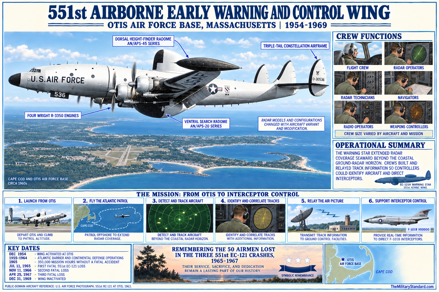
The 551st wing activated in December 1954 and expanded rapidly. Its flying squadrons and support organizations sustained continuous patrols over the Atlantic approaches, training, maintenance, and alert. A 1958 Air Force Association account described an organization with approximately 40 aircraft and roughly 3,000 personnel, an indication of the scale reached during the peak period. Aircrews, radar operators, radio operators, navigators, maintenance specialists, weather personnel, and ground controllers together turned the aircraft into moving extensions of the air-defense network.
Warning Star patrols were demanding. Aircraft flew long missions over cold water in changing weather, while crews monitored radar displays, maintained communications, identified tracks, and coordinated with direction centers and interceptor bases. Engines, pressurization, radar, electrical systems, and navigation equipment required intensive maintenance. Otis needed large hangars, ramps, supply stocks, engine shops, avionics work, survival equipment, rescue coordination, and crew-rest arrangements. The airborne mission therefore transformed both the tempo and physical scale of the base.
The 551st achieved an extraordinary operational record, including 350,000 mission hours without a fatal accident by March 2, 1965. That milestone did not eliminate risk. EC-121 crashes on July 11, 1965, November 11, 1966, and April 25, 1967, killed a total of 50 crew members. The losses deeply affected the Otis community and are central to the installation's human history. Memorialization at Joint Base Cape Cod preserves the names and service of the airmen rather than reducing the mission to equipment and sortie totals.
Technological and organizational change ended the wing's mission. Improved ground systems, satellites, changing threat assessments, and force reductions altered the requirement for continuous EC-121 picket operations. The 551st Airborne Early Warning and Control Wing inactivated on December 31, 1969. Its departure closed one of Otis's largest active-duty missions, but the base continued fighter interception, support, communications, and missile relationships. The former warning mission remains visible in photographs, unit records, survivor accounts, memorials, and the extensive flight-line plant that such aircraft required.
Texas Tower Support
Otis was the shore base for the Texas Tower program, which placed staffed radar platforms on Atlantic shoals to push warning coverage hundreds of miles seaward. The 4604th Aircraft Control and Warning Squadron, Texas Towers, activated at Otis on September 28, 1956. On October 8, responsibility for the developing offshore mission transferred from the 762d Aircraft Control and Warning Squadron at North Truro. The Otis unit was redesignated the 4604th Support Squadron in December 1956; available records conflict between December 1 and December 31, so only the month is asserted here.
The 4604th provided administrative, logistical, maintenance, supply, helicopter, and transportation support for Texas Tower No. 2 on Georges Shoal, Texas Tower No. 3 on Nantucket Shoal, and Texas Tower No. 4 off New Jersey. Otis received personnel and cargo, prepared equipment, scheduled airlift and sealift, maintained special systems, and coordinated replacements and emergencies. Helicopters connected the towers to shore when weather and platform conditions permitted, while ships carried heavier supplies. The offshore radar sites depended on this shore infrastructure even though each tower was a distinct installation.
Texas Tower support joined several Otis strengths. The base already had long runways, extensive maintenance and supply organizations, communications with regional air-defense centers, rescue capability, and access to Atlantic ports. North Truro remained operationally important to the tower network, and other bases contributed aircraft and marine support, but Otis became the program's principal administrative and logistics center. This relationship explains why histories of the towers repeatedly return to Otis even though the steel platforms stood far offshore.
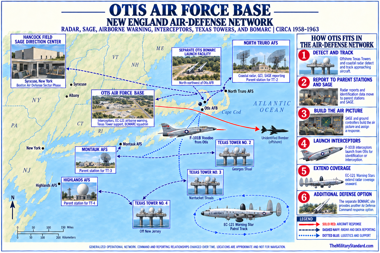
The collapse of Texas Tower No. 4 on January 15, 1961, killed 28 men and exposed the hazards of maintaining staffed radar stations at sea. Otis participated in the program's support and response network and shared the institutional consequences of the disaster. Texas Towers No. 2 and No. 3 left operational service in 1963, and the specialized support requirement ended. The 4604th history belongs within Otis, but the individual tower construction, operation, property, and casualty records remain in their separate installation histories.
SAGE, BOMARC, and the Regional Network
The Semi-Automatic Ground Environment integrated radar inputs, direction centers, communications, fighters, and missiles. Otis did not contain the permanent North Truro radar or a SAGE direction center, yet its interceptor aircraft, airborne warning tracks, communications, and missile squadron operated within the SAGE-controlled network. Computers consolidated reports and enabled controllers to assign targets and transmit guidance. Otis provided the mobile response and seaward sensing that complemented fixed radars and command centers across New England.
The 26th Air Defense Missile Squadron activated at Otis in 1959 to operate Boeing BOMARC long-range surface-to-air missiles. Its launch complex stood north-northwest of the airfield, within the broader reservation but treated as an off-base facility supported by Otis. Construction, missile shelters, hazardous-material history, separate fencing, and later Army reuse establish a distinct physical installation.
The BOMARC system offered a second means of engaging bombers after radar detection. The missile received guidance through the air-defense command network, used a ramjet during cruise, and could carry a conventional or nuclear warhead depending on model and assignment. Otis operated both A and B model phases, with the solid-fueled B model replacing the earlier liquid-fueled version. The 26th squadron ceased operations in April 1972 and inactivated on April 30, ending the launch mission shortly before the active-duty base drawdown.
Cape Cod Air Force Station represents another distinct network layer. PAVE PAWS construction began on Flatrock Hill in 1976, units activated in 1979, and the phased-array radar became operational on April 4, 1980. The site received the Cape Cod Air Force Station name in 1982, entered the Space Force in 2019, and became Cape Cod Space Force Station in 2021. Its current AN/FPS-132 radar provides missile warning, missile-defense support, and space surveillance.
Facilities, Community, and Presidential Support
At its active-duty peak, Otis functioned as a military town. The flight line included long runways, taxiways, aprons, hangars, alert facilities, fueling, fire and rescue, and specialized aircraft-maintenance buildings. The cantonment provided headquarters, barracks, family housing, dining, medical care, education, worship, retail, recreation, utilities, security, and transportation. Tenant organizations used shared services, and the surrounding Cape economy supplied labor, housing, contracting, and businesses. The base's social history includes military families and civilian employees as much as aircraft and radar.
Rapid construction left a layered architectural record. WPA-era structures, wartime buildings, standardized 1950s Air Force facilities, later Guard buildings, and modern intelligence and communications spaces coexist or replaced one another. Environmental cleanup and new missions have removed or altered many older structures. Determining which surviving building served a particular squadron requires real-property records, historic maps, and architectural surveys. General photographs can document the installation without proving a building-level identification, and captions should preserve that distinction.
Otis also supported presidential travel during the John F. Kennedy administration. The Kennedy family compound at Hyannis Port made Cape Cod a frequent destination, and Air Force One used Otis as a secure regional airfield. Official reservation history identifies Building 102 as an office associated with presidential support and Building 110 as the Kennedy Cottage. Communications, security, motor transport, medical readiness, and airfield operations supported these visits. The mission was highly visible but secondary to the continuing continental defense role.
The presidential phase illustrates the value of Otis beyond assigned units. A large, secure airfield near eastern Massachusetts could support national command movement, emergency response, distinguished visitors, exercises, and transient aircraft. Similar capabilities later aided disaster relief and homeland-security operations. These functions should not be converted into claims that every transient organization was based at Otis. The installation provided infrastructure and support, while operational control often remained with visiting commands or federal agencies.
Air National Guard Transition
Air Defense Command reductions changed Otis in the early 1970s. The 60th Fighter-Interceptor Squadron inactivated on April 30, 1971, the 26th Air Defense Missile Squadron followed on April 30, 1972, and other active-duty functions contracted. In 1973 the installation was redesignated Otis Air National Guard Base. Official 102nd Wing material characterizes the earlier Otis as the largest Air Defense Command base in the world, a description of its peak mission concentration rather than a surveyed acreage ranking.
The boundary redistribution was a process rather than a single closure. By 1977 the former active-duty base functions had been divided among Otis Air National Guard Base, Camp Edwards, and Coast Guard Air Station Cape Cod. The Army resumed direct control of Camp Edwards in 1975. The Coast Guard air station had already commissioned at Otis on August 29, 1970. Air Force active-duty personnel returned for PAVE PAWS in 1978, but at the separate Flatrock Hill radar site. These changes produced today's multi-service reservation.
The 102nd Tactical Fighter Wing moved from Logan International Airport to Otis in August 1968, before the active-duty drawdown was complete. It flew the F-84F through June 1971, then received F-100D aircraft returning from Southeast Asia. On June 10, 1972, the organization became the 102nd Air Defense Wing and entered the F-106 Delta Dart era. Its crews maintained continuous alert and took over a central part of the New England interceptor mission as active-duty units departed.
The Guard wing conducted real-world identifications as well as training. On April 25, 1975, its fighters intercepted a Soviet Tu-95 Bear D reconnaissance aircraft about 240 nautical miles off Long Island. Such missions demanded coordination with national radar and command systems, tanker and rescue support, weather forecasting, and disciplined rules of engagement. The intercept showed that the Guard transition did not end Otis's operational defense role. It transferred that responsibility to a state-based force available for federal missions.
Otis became the first Air National Guard air-defense unit to receive the F-15 Eagle. The first aircraft arrived in the fall of 1987, replacing the aging F-106 with a faster fighter, modern radar, and improved weapons. In April 1992 the organization became the 102nd Fighter Wing. The F-15 era included alert, exercises, deployments, and expeditionary operations while preserving the home-station air sovereignty mission. New aircraft also drove changes in maintenance, avionics, weapons, training, and support facilities.
Expeditionary Operations and Homeland Defense
The 102nd Wing supported operations beyond New England. Its record includes Coronet Nighthawk support in Panama from 1991 through 1995, deployments to Iceland from 1995 through 1998, Operation Northern Watch in Turkey in 1999, and Operation Southern Watch in 2000. These missions placed Otis personnel and aircraft within joint and allied command structures. They also tested the base's mobilization, maintenance, supply, medical, communications, and family-support systems while home alert obligations continued.
On September 11, 2001, two 102nd Fighter Wing F-15s launched from Otis in response to the developing hijacking crisis. They reached the New York City area about six minutes after the second World Trade Center impact. The timing reflects the speed of an alert launch but also the severe limits of warning and information available that morning. More than 600 wing members were mobilized, and the wing sustained around-the-clock combat air patrols until February 2002.
The wing's 2001 operational totals demonstrate the scale of the response. Official history credits 2,388 sorties and more than 3,750 flying hours during the year. Maintenance, weapons, fuel, security, communications, air traffic control, medical, and command personnel enabled those flights. The mission restored a wartime tempo to a base whose continental defense purpose dated to 1948. It also made Otis one of the most publicly recognized Air National Guard alert bases in the United States.
Later homeland-defense operations continued under evolving national command arrangements. Fighters at Otis participated in air sovereignty alert and exercises, while intelligence and communications personnel increasingly supported distributed missions. The installation's coastal position remained relevant, but modern data links, national sensors, and networked command allowed effects far beyond local radar range. Otis evolved from a place where aircraft and radar were physically concentrated into a node that could collect, analyze, communicate, and direct information worldwide.
2005 BRAC and the Intelligence Transformation
The 2005 Base Closure and Realignment process directed removal of the assigned F-15 aircraft from Otis. The decision ended the 102nd Fighter Wing's home-station flying mission but did not close Otis Air National Guard Base. Aircraft departed through transfers and retirements, and the final ceremonial F-15 sortie occurred in January 2008. The distinction is essential: a mission realignment can remove aircraft while leaving an active installation, personnel, facilities, and new missions in place.
On April 6, 2008, the 102nd Fighter Wing became the 102nd Intelligence Wing. Some official summaries use April 1 for the broad conversion period, but the wing lineage history identifies April 6, which this account uses for the formal redesignation. The new organization developed intelligence, surveillance, and reconnaissance exploitation capabilities, including a Digital Ground Station that processed data from remotely piloted aircraft and other sources. Personnel retrained from a flying-wing culture to around-the-clock distributed intelligence operations.
The transition also created command and control and cyber-related missions. An Air Operations Group activated in October 2008, providing capabilities connected to air operations, communications, and command systems. The 253rd Cyberspace Engineering Installation Group remained a major Otis tenant and leader in engineering and installing expeditionary communications infrastructure, cable and antenna systems, radar, airfield equipment, and weather systems. Its eight engineering and installation squadrons extend Otis expertise to missions around the world.
A purpose-built intelligence facility marked the institutional maturity of the new wing. The $17.6 million complex opened on October 8, 2015, giving analysts secure, modern space for distributed intelligence operations. The facility represented more than replacement construction. It anchored a mission in which information collected elsewhere could be received, processed, analyzed, and delivered from Cape Cod to operational commanders. The investment confirms that Otis remained an active Air Force installation after the loss of assigned fighters.
Current Missions and Joint Base Relationships
The 102nd Intelligence Wing's current mission is to provide worldwide precision intelligence and command and control, along with trained forces for expeditionary combat support and homeland security. Its structure includes intelligence and reconnaissance organizations, mission support, medical capability, and command functions. The mission can be operational without launching aircraft from KFMH because modern intelligence production and command support depend on secure networks, trained analysts, communications, and data rather than a locally assigned flying squadron.
The 102nd Mission Support Group sustains the installation and its tenants. An official commander biography describes more than 400 personnel providing engineering, contracting, supply, transportation, personnel, services, communications, calibration, logistics, and security support. The group supports 31 tenant organizations and about 5,000 personnel across Joint Base Cape Cod. These figures describe a current support responsibility, not 5,000 personnel assigned to the 102nd Wing or an Otis-only population.
The 253rd Cyberspace Engineering Installation Group provides another current Air Force mission. Its subordinate units can survey, design, install, test, and restore communications infrastructure in deployed and fixed environments. Work can include cable and antenna systems, radar, airfield systems, weather equipment, and related facilities. This mission creates a direct historical continuity with Otis's long association with radar and communications, but its modern purpose is global engineering and cyberspace support rather than local operation of the former L-5 radar.
Coast Guard Air Station Cape Cod has occupied the Otis aviation complex since its commissioning on August 29, 1970. Its aircraft and missions evolved from HH-52A helicopters and HU-16E amphibians to later HH-3F, HH-60, HU-25, and successor types. In October 2008 the Coast Guard assumed responsibility for operating the airfield, including maintenance, runway lights, tower, weather, navigation aids, and snow removal. Since August 2014, the air station has been a tenant of Coast Guard Base Cape Cod, another organizational change that does not end the airfield's Otis identity.
Joint Base Cape Cod was adopted as the reservation name in 2013. It is a cooperative multi-service installation rather than a Department of Defense joint base created through the standard 2005 BRAC consolidation model. Camp Edwards, Otis Air National Guard Base, Coast Guard Base Cape Cod, Cape Cod Space Force Station, the Massachusetts National Cemetery, and other tenants retain distinct commands and land responsibilities while sharing infrastructure and coordinating security, emergency services, environmental restoration, and planning.
Current access is controlled. Joint Base Cape Cod is a secure federal military installation, and official controlled access instructions limit entry to authorized personnel and approved visitors. Public roads and nearby recreation do not make former missile, radar, range, or airfield areas open for exploration. Historic photographs and maps can identify general locations, but they do not authorize access.
Environmental Restoration
Decades of aviation, fuels handling, fire training, landfills, maintenance, solvents, munitions training, and industrial support produced extensive environmental contamination across the reservation. The Otis Air National Guard Base/Camp Edwards area entered the National Priorities List in 1989, and a federal facility agreement followed in 1991 with later amendments. Contamination threatens the Sagamore Lens, a sole-source aquifer that supplies drinking water to Cape Cod communities. Environmental history is therefore a core part of Otis, not an appendix to operations.
Cleanup is divided into operable units, plumes, source areas, and responsible programs rather than assigned to a single installation label. Groundwater contaminants have included fuels, solvents, and other chemicals released from landfills, fire-training areas, fuel systems, maintenance operations, and spills. Some munitions-response work falls within the Camp Edwards impact area under separate authorities. The boundaries of an environmental study area may cross historic service boundaries, so a plume called Otis does not prove Air Guard ownership of every source or treatment facility.
The former BOMARC and Unit Training Equipment Site area, designated CS-10 and FS-24 in restoration records, illustrates this complexity. The approximately 38-acre source area lies near the northeastern reservation boundary and includes the former missile complex later used by the Army. Investigations addressed solvents, fuels, building materials, drains, leaching structures, and groundwater effects.
Firefighting foam introduced another environmental issue. A 2015 Air Force assessment identified 21 areas evaluated for aqueous film-forming foam use and 14 potential release locations within the joint-base setting. Subsequent investigation and response addressed perfluoroalkyl and polyfluoroalkyl substances, commonly called PFAS. The record continues to evolve as standards, sampling, treatment, and responsibility decisions change.
EPA reporting in 2025 described active treatment of four groundwater plumes at a combined rate of about 5.4 million gallons per day and completion of cleanup construction at six other plumes. Long-term monitoring, extraction and treatment, land-use controls, and reviews continue. These figures apply to the federal Superfund installation program and should not be read as an Otis Air Guard-only performance measure. They demonstrate the scale and duration of restoration and the need to preserve source-area distinctions.
Environmental restoration has affected demolition, land reuse, construction, and access. Buildings or utilities may be removed for remediation, while treatment plants and monitoring wells can remain after military missions change. Records of decision and five-year reviews document remedy selection and protectiveness but do not necessarily settle fee title or historic building identity.
Historic Resources, Memorials, and Legacy
Otis retains a layered legacy in surviving buildings, runway patterns, memorials, photographs, and unit traditions. The 551st memorial is especially important because it connects the EC-121 mission to the 50 airmen lost in three crashes. Presidential-support buildings, early cantonment structures, Cold War hangars, alert facilities, and later Guard buildings may also carry historic value. Each feature needs building-specific documentation before a caption assigns a date or function, because decades of renovation and reuse can conceal original purposes.
The base's aviation legacy continues even without an assigned Air Guard fighter squadron. Coast Guard aircraft operate from the field, military units train and deploy, and the Air National Guard performs intelligence, command, cyber engineering, medical, security, and installation-support missions. The runway complex remains a strategic regional asset. Otis history is therefore not a narrative of decline from a great Cold War base, but a record of adaptation from physical intercept systems to networked information and support operations.
The installation's community legacy extends throughout Cape Cod. Generations of service members, dependents, civilian employees, contractors, and local businesses participated in the base economy and culture. Housing, schools, medical services, recreation, and religious life shaped experiences that operational records rarely capture. At the same time, noise, land restrictions, crashes, cleanup, and changing employment affected neighboring towns.
Chronology
- 1921 The 101st Observation Squadron is organized in the Massachusetts National Guard, creating the aviation lineage later associated with Otis.
- 1935 Development of the Massachusetts Military Reservation and its aviation field begins through Commonwealth, federal, and Works Progress Administration activity.
- January 11, 1937 First Lieutenant Frank Jesse Otis dies after an aircraft accident; the Cape Cod field will be named in his honor.
- July 1938 Camp Edwards is dedicated as the principal Army training installation on the reservation.
- 1938 The landing area is named Otis Field.
- 1935-1940 More than 600 workers construct approximately 63 buildings and two broad turf runways in the reservation development program.
- 1940-1941 The 101st Observation Squadron moves from the Boston area to Otis; official histories disagree on the exact year.
- 1941-1943 The 14th Antisubmarine Patrol Squadron conducts offshore patrol activity from Otis.
- 1942 Concrete runways are built for wartime operations.
- 1943 Runways are lengthened and widened as the field expands.
- 1944 The Navy assumes the principal coastal reconnaissance responsibility and uses Otis during the remaining wartime period.
- 1945 The 101st Observation Squadron returns from wartime service overseas.
- 1946 Camp Edwards and Otis enter inactive or caretaker status after wartime demobilization.
- July 29, 1946 The 101st is reactivated in the Massachusetts National Guard.
- 1946-1948 An Otis runway is extended to approximately 8,000 feet during the postwar transition.
- 1948 The United States Air Force assumes control and establishes Otis Air Force Base.
- November 16, 1948 The 60th Fighter Squadron begins an Otis assignment within the 33d organization.
- July 1950 Lashup radar site L-5 is operational at Otis with AN/CPS-5 and AN/TPS-10A equipment.
- August 10, 1950 The 60th Fighter Squadron moves from Otis to Westover.
- 1950 Camp Edwards reactivates during the Korean War emergency, while Otis expansion accelerates.
- October 1951 L-5 is inactivated as North Truro P-10 assumes the permanent radar role.
- 1951-1956 A major Air Force construction program adds hangars, support buildings, housing, and infrastructure.
- 1954 Congress authorizes transfer of the military airfield and much of the main-post area from the Army to the Air Force.
- December 1954 The 551st Airborne Early Warning and Control Wing activates at Otis.
- August 18, 1955 The 60th returns to Otis, initially operating all-weather interceptors.
- August 1955 Project Arrow restores the historic 33d Fighter Group designation within the Otis air-defense structure.
- September 28, 1956 The 4604th Aircraft Control and Warning Squadron, Texas Towers, activates at Otis.
- October 8, 1956 Texas Tower program responsibility transfers from the 762d at North Truro to the Otis organization.
- December 1956 The 4604th becomes the 4604th Support Squadron; surviving sources conflict on the day.
- 1958 Published contemporary reporting describes the 551st as a roughly 40-aircraft, 3,000-person organization.
- 1959 The 26th Air Defense Missile Squadron activates at Otis, and construction of the BOMARC launch complex proceeds north-northwest of the airfield.
- 1959 The 60th becomes the first Air Defense Command squadron to operate the F-101B interceptor.
- 1960 The Otis BOMARC complex enters its operational era.
- January 15, 1961 Texas Tower No. 4 collapses, killing 28 men and transforming the offshore radar program.
- 1963 Texas Towers No. 2 and No. 3 leave operational service, ending the surviving staffed offshore stations.
- March 2, 1965 The 551st marks 350,000 mission hours without a fatal accident.
- July 11, 1965 A 551st EC-121 crashes with fatal loss of crew.
- November 11, 1966 A second fatal 551st EC-121 crash occurs.
- April 25, 1967 A third fatal 551st EC-121 crash occurs; the three accidents ultimately account for 50 deaths.
- August 1968 The 102nd Tactical Fighter Wing moves from Logan International Airport to Otis.
- December 31, 1969 The 551st Airborne Early Warning and Control Wing inactivates.
- August 29, 1970 Coast Guard Air Station Cape Cod commissions within the Otis aviation complex.
- April 30, 1971 The 60th Fighter-Interceptor Squadron inactivates.
- June 1971 The 102nd ends F-84F operations and transitions toward the F-100D.
- April 1972 The 26th Air Defense Missile Squadron ends operations at the separate BOMARC launch complex.
- April 30, 1972 The 26th Air Defense Missile Squadron inactivates.
- June 10, 1972 The 102nd becomes the 102nd Air Defense Wing and begins its F-106 era.
- 1973 Otis Air Force Base is redesignated Otis Air National Guard Base.
- April 25, 1975 Otis fighters intercept a Soviet Tu-95 Bear D about 240 nautical miles off Long Island.
- 1975 The Massachusetts Army National Guard resumes direct control of Camp Edwards.
- 1977 Official boundary redistribution recognizes Otis ANGB, Camp Edwards, and Coast Guard Air Station Cape Cod as distinct major components.
- 1978 Active-duty Air Force activity returns for PAVE PAWS at the separate Flatrock Hill radar site.
- October 1, 1979 The 6th Missile Warning Squadron and 2165th Communications Squadron activate for the PAVE PAWS mission.
- April 4, 1980 The Cape Cod PAVE PAWS radar becomes operational.
- January 5, 1982 The radar installation receives the name Cape Cod Air Force Station.
- 1986 Missile-warning units at Cape Cod are consolidated as the 6th Space Warning Squadron lineage.
- Fall 1987 The first F-15 Eagles arrive, making the Otis unit the first Air National Guard air-defense organization to receive the type.
- 1989 The Otis Air National Guard Base/Camp Edwards environmental site is placed on the National Priorities List.
- 1991 A federal facility agreement establishes the principal Superfund cleanup framework.
- April 1992 The 102nd Air Defense Wing becomes the 102nd Fighter Wing.
- 1991-1995 Otis personnel and aircraft support Coronet Nighthawk operations in Panama.
- 1995-1998 The wing conducts recurring deployments to Iceland.
- 1999 The 102nd supports Operation Northern Watch from Turkey.
- 2000 The 102nd supports Operation Southern Watch.
- September 11, 2001 Two Otis F-15s launch during the terrorist attacks; the wing begins sustained combat air patrol operations.
- February 2002 The initial continuous post-attack combat air patrol period concludes after months of around-the-clock activity.
- August 26, 2002 The Cape Cod radar land permit is extended through September 30, 2026.
- 2005 Base Closure and Realignment decisions direct removal of the 102nd Fighter Wing's assigned F-15 aircraft without closing Otis ANGB.
- January 2008 The 102nd conducts its final ceremonial F-15 sortie at Otis.
- April 6, 2008 The 102nd Fighter Wing is formally redesignated the 102nd Intelligence Wing.
- October 2008 The Coast Guard assumes responsibility for KFMH airfield operations and maintenance.
- October 2008 An Air Operations Group activates as part of the new intelligence and command structure.
- 2013 Massachusetts Military Reservation is renamed Joint Base Cape Cod.
- August 2014 Coast Guard Air Station Cape Cod becomes a tenant of Coast Guard Base Cape Cod.
- 2015 An Air Force assessment identifies 21 areas evaluated for firefighting-foam use and 14 potential release locations in the joint-base environment.
- October 8, 2015 The 102nd Intelligence Wing opens a $17.6 million intelligence facility.
- December 20, 2019 The 6th Space Warning Squadron enters the United States Space Force.
- July 24, 2020 The 6th Space Warning Squadron becomes part of Space Delta 4.
- June 11, 2021 Cape Cod Air Force Station is renamed Cape Cod Space Force Station.
- April 2025 EPA reporting describes four groundwater plumes under active treatment at about 5.4 million gallons per day and six completed plume cleanups.
- 2025 The 253rd Cyberspace Engineering Installation Group continues oversight of eight engineering and installation squadrons.
- 2026 The 102nd Intelligence Wing remains active at Otis and conducts combat-readiness training for intelligence, command, support, medical, and security missions.
Information sources (32)
- WEBOtis Air National Guard Base and Massachusetts Military Reservation Fact Sheet, 102nd Intelligence Wing
Official Air National Guard account of the Otis name, Air Force and Air Guard phases, 1977 redistribution, and PAVE PAWS return.
- WEBHistory of the 102nd Intelligence Wing, 102nd Intelligence Wing
Official wing lineage and narrative covering the 101st, move to Otis, aircraft transitions, September 11 response, and intelligence conversion.
- WEBHistory of the 102nd Intelligence Wing PDF
Official downloadable version of the wing history used to verify operational milestones and mission changes.
- WEB102nd Intelligence Wing About Page
Official current mission statement for precision intelligence, command and control, expeditionary support, and homeland security.
- WEBCamp Edwards History, Massachusetts National Guard
Official reservation history covering WPA construction, Otis Field, wartime expansion, Air Force transfer, interceptor units, BOMARC, and presidential support.
- WEBJoint Base Cape Cod Overview, Massachusetts National Guard
Official description of the joint-base setting, component missions, training area, and multi-service organization.
- WEBJoint Base Cape Cod Main Page, Massachusetts National Guard
Official portal for current installation organizations, environmental programs, and public information.
- WEBJoint Base Cape Cod Access Information
Official security and access guidance supporting the controlled-access qualification in the history.
- WEB102nd Intelligence Wing Opens State-of-the-Art Intelligence Facility
Official account of the $17.6 million facility opening on October 8, 2015 and the intelligence mission it supports.
- WEB253rd Cyberspace Engineering Installation Group Welcomes New Commander
Official 2025 description of the group's eight squadrons and expeditionary communications, cable, antenna, radar, airfield, and weather-system mission.
- WEBColonel Michael C. Kelley Biography, 102nd Intelligence Wing
Official source for the current Mission Support Group scope, more than 400 personnel, 31 tenant organizations, and support to approximately 5,000 personnel.
- WEB102nd Intelligence Wing Tests Mission Capabilities During Combat Readiness Inspection
Official 2026 evidence of current intelligence, support, medical, security, and readiness activity at Otis.
- WEB33rd Operations Group Fact Sheet
Official Air Force lineage source for the 33d move to Otis, its Air Defense Command role, and Project Arrow restoration.
- WEB60th Fighter Squadron Fact Sheet
Official source for the squadron's Otis assignments, F-94 period, first Air Defense Command F-101 operation, and 1971 inactivation.
- PDF33rd Fighter Wing Historical Pamphlet
Official unit history used to place the 33d organization and fighter squadrons within the postwar Otis mission.
- PDFADC Historical Data, 1946-1973 (17.67 MB)
Air Defense Command compilation used for L-5 equipment and dates, Otis and North Truro relationships, unit listings, and Texas Tower support chronology.
- PDFA History of Texas Towers in Air Defense, 1952-1964
Air Defense Command historical study documenting the 4604th organization, Otis shore support, tower relationships, and program chronology.
- WEBADC and Antibomber Defense, 1946-1972
Officially released Air Defense Command study used for strategic context, SAGE, fighter control, airborne warning, and BOMARC integration.
- WEBThe Stars Above, Air and Space Forces Magazine
Professional historical account used for the 551st Warning Star mission record, 350,000-hour milestone, three crashes, casualties, and inactivation.
- PDFAir Force Magazine, June 1958
Contemporary period publication used for the approximate scale of the 551st airborne-warning force at Otis.
- PDFSeagull, December 2017, 102nd Intelligence Wing
Official wing publication with a historical feature on the 26th Air Defense Missile Squadron and Otis BOMARC mission.
- PDFRecord of Decision, CS-10 and FS-24 Source Areas
EPA administrative record describing the 38-acre former BOMARC and fuel-spill area, reservation functional areas, contamination, and remedy context.
- WEBOtis Air National Guard Base and Camp Edwards Superfund Site Profile
EPA current site information used for National Priorities List status, federal agreement, aquifer risk, cleanup progress, treatment, and monitoring.
- PDFJoint Base Cape Cod Time-Critical Removal Action Memorandum, July 19, 2018
Official military environmental memorandum used for land-use chronology, functional acreages, Coast Guard transfer, PAVE PAWS, PFAS assessment, and 2013 renaming.
- WEBBase Cape Cod Environmental Management System Manual
Official Coast Guard source for reservation land context, Air Station commissioning, 2008 airfield responsibility, and 2014 Base Cape Cod relationship.
- WEBAir Station Cape Cod, Massachusetts, Coast Guard Historian's Office
Official Coast Guard station history and photo gallery documenting the August 29, 1970 commissioning, aircraft types, missions, and continued operation.
- WEB6th Space Warning Squadron Fact Sheet, United States Space Force
Official source for PAVE PAWS planning, construction, activation, land permit, Cape Cod station names, Space Force transfer, current AN/FPS-132 radar, and mission.
- WEBChief of Space Operations Visits 6th Space Warning Squadron
Official 2024 description of the current Cape Cod Space Force Station missile-warning and space-surveillance mission.
- PDFGAO Review of the 2005 Defense Base Closure and Realignment Selection Process
Government source used to frame the 2005 realignment decision and distinguish loss of assigned aircraft from installation closure.
- PDFNational Telecommunications and Information Administration Manual, Chapter 8
Federal frequency-management table independently identifying Cape Cod AFS and its representative phased-array radar coordinate.
- WEBOtis ANGB and Camp Edwards EPA Administrative Records Collection
Official index to federal cleanup records, decisions, reviews, and supporting documents for the installation complex.
- WEBDirections to Otis Air National Guard Base
Official 102nd Intelligence Wing visitor information supporting the current Otis name and controlled installation context.