
Texas Tower No. 4 / Unnamed Shoal Radar Station, New Jersey
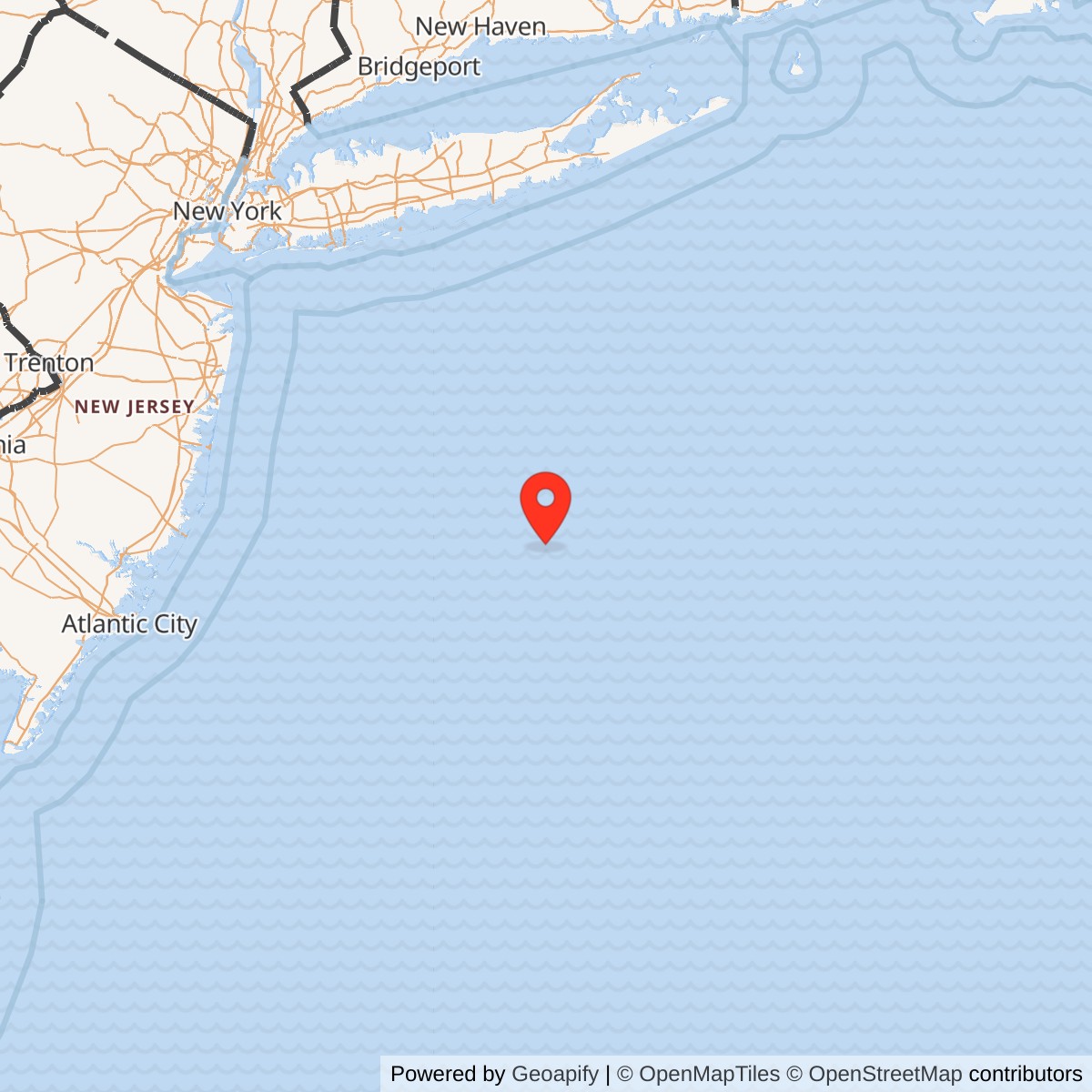
Longitude: -72.644
Site Number: TT-4
Official Base Website: Submerged wreck of Texas Tower No. 4 / Unnamed Shoal Radar Station
Current Role: Submerged wreck, unrecovered-grave site, advanced technical-dive hazard, and Cold War cultural resource in approximately 185 feet of Atlantic water. NOAA retains the name Texas Tower #4 for station 44066 at the representative wreck-area point, but reports the buoy recovered on 2024-04-16 and provides no current observations. No staffed radar installation remains. Exact wreck center, debris field, artifact custody, environmental condition, and seabed property status are unresolved.
Texas Tower No. 4 was a fixed offshore United States Air Force radar station on Unnamed Shoal in the Atlantic east of New Jersey. Air Defense Command built it to extend long-range search and height-finding coverage beyond the coast, increase warning time against bomber approaches, and feed seaward tracks into the continental air-defense network. The platform was constructed at South Portland, Maine, placed at its deep-water station in 1957, began documented manual radar operations in April 1959, entered the SAGE system in April 1960, and collapsed in a winter storm on January 15, 1961.
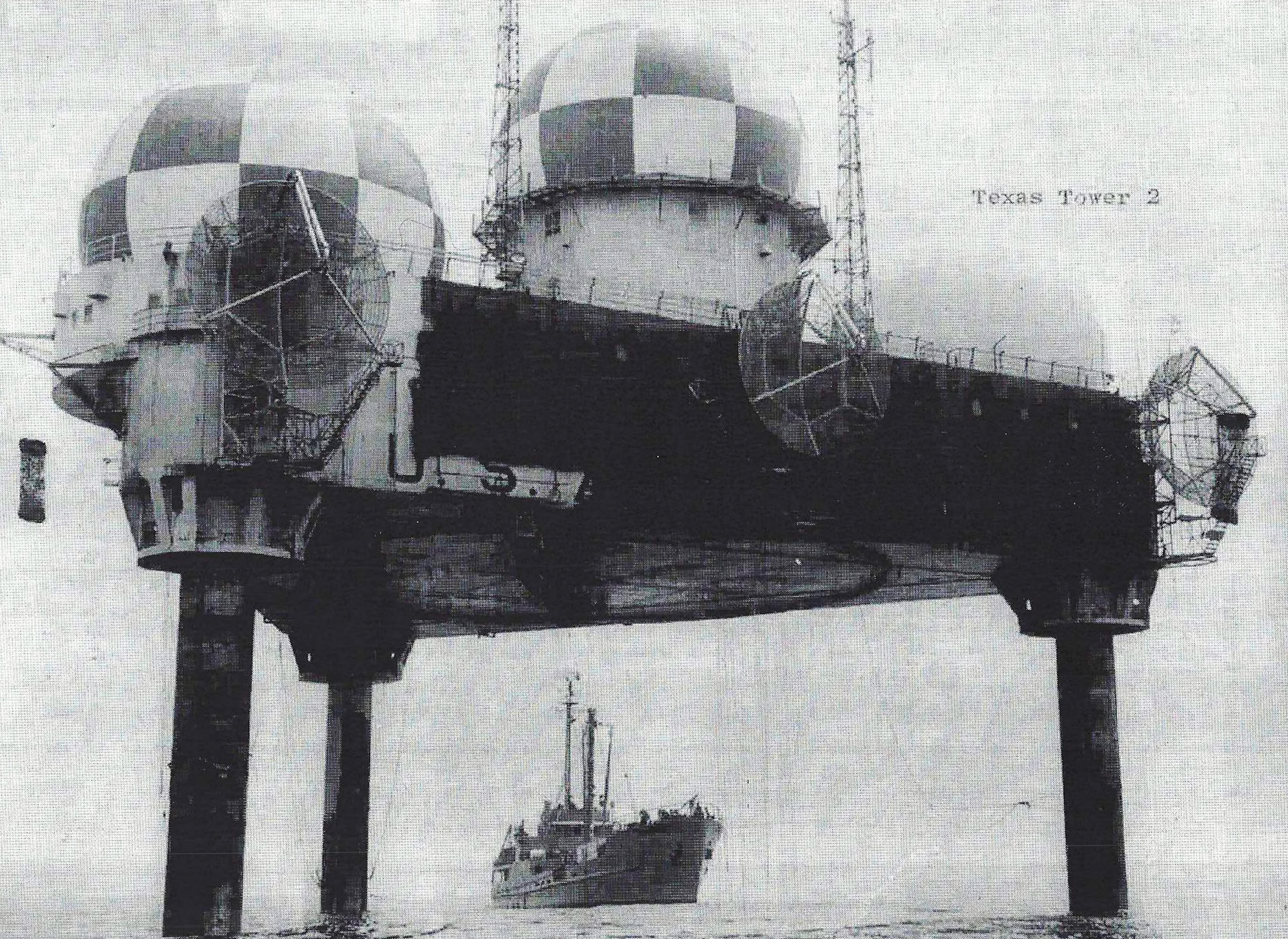
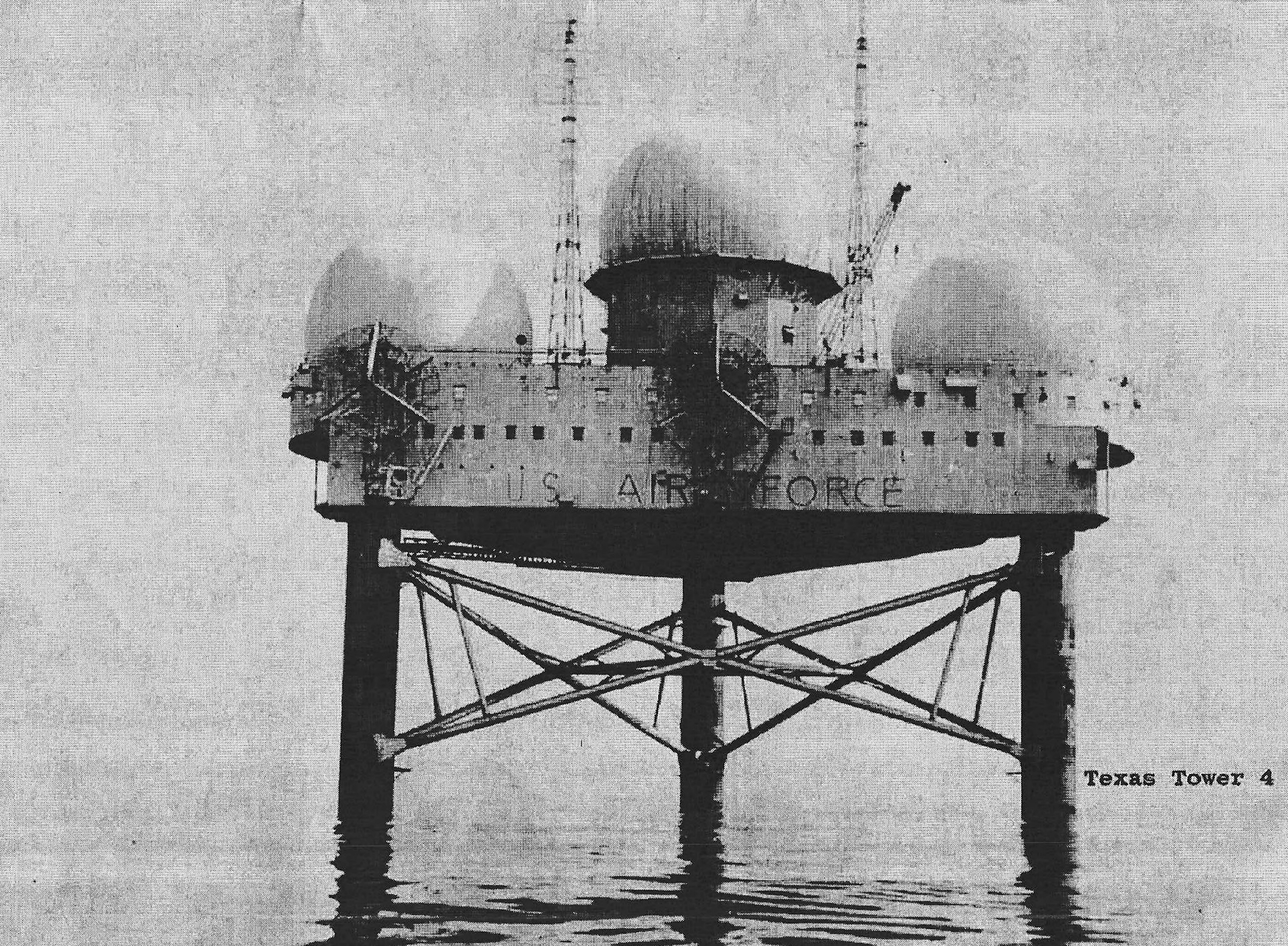
TT-4 was the deepest and most structurally demanding of the three completed Texas Towers. Its enclosed triangular platform carried radars, communications, diesel power generation, water production, machinery, shops, storage, living quarters, medical space, a galley, recreation rooms, and a helicopter deck. Three steel legs and a much larger underwater bracing system supported the station in about 185 feet of water. The operating mission therefore depended on marine construction, diving, corrosion control, weather forecasting, aircraft and vessel support, and continuous judgment about a structure whose movement became a persistent warning.
The installation is remembered principally for the loss of all twenty-eight men aboard: fourteen Air Force personnel and fourteen civilian repairmen. Two diagonal braces were lost during the 1957 tow and emplacement process, connection problems appeared later, repeated repairs did not end abnormal motion, and Hurricane Donna caused grave damage in September 1960. A December gale and a newly discovered broken lower brace further reduced confidence. On January 12, 1961, the design engineers declined to state the tower's remaining strength, yet the caretaker and repair party remained during the storm three days later.
The collapse produced a major Navy search and diving operation, an Air Force fact-finding investigation, a Senate Armed Services Committee inquiry, engineering reassessment, civil litigation, and lasting memorial work. The Senate Preparedness Investigating Subcommittee concluded that design criteria were inadequate, that construction and repair decisions left the tower compromised, and that the Air Force bore substantial responsibility for the loss of life because it did not obtain a reliable independent strength evaluation or evacuate in time. Those are official investigative conclusions, not a claim that every participant or later analyst agreed on every detail.
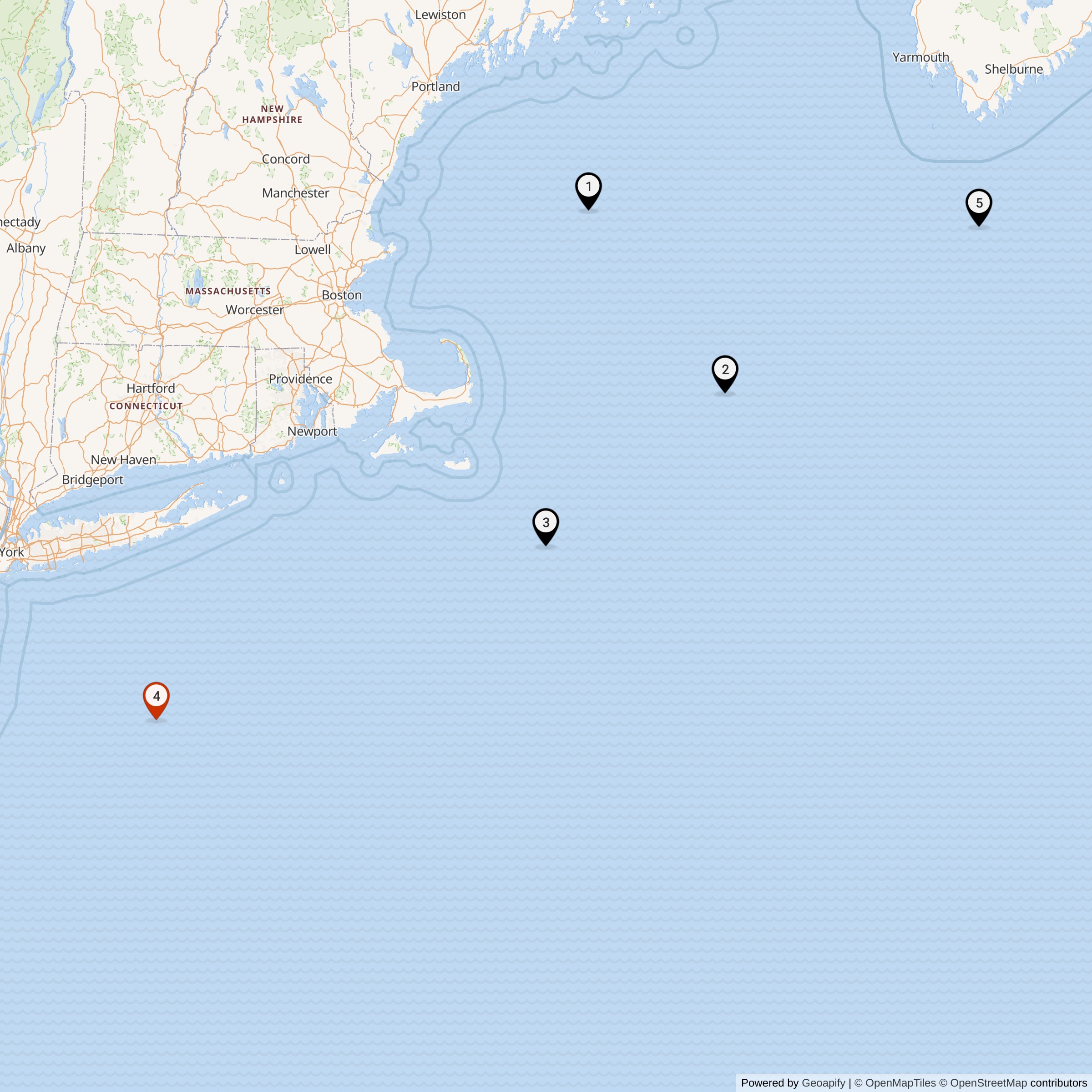
Today the installation is a submerged wreck and grave site rather than an operating base. NOAA retains the name Texas Tower #4 for data buoy station 44066 at 39.618 north latitude, 72.644 west longitude, but NOAA reports that the buoy was recovered on April 16, 2024 and provides no current observations. That buoy position is used here only as a representative wreck-area coordinate. It is not asserted to be the surveyed center of the former platform, the center of every scattered component, a legal boundary, a safe navigation point, or permission to dive or disturb the site.
Installation Identity, Name, and Scope
Texas Tower No. 4, Texas Tower 4, TT-4, Unnamed Shoal Radar Station, and the Unnamed Shoal Texas Tower identify the same operating Air Defense Command installation. The formal site code was TT-4. The Texas Tower name referred to the resemblance between the platforms and offshore oil structures first associated with the Gulf Coast. It did not indicate a location in Texas, an Army observation tower, a conventional land-based radar tower, or a Navy vessel.
The station must be distinguished from Highlands Air Force Station in New Jersey, Otis Air Force Base in Massachusetts, North Truro Air Force Station, and the 646th Radar Squadron and 4604th Support Squadron organizations connected with its mission. Highlands and the 646th supplied the operational parent relationship commonly documented for TT-4. Otis and the 4604th supplied specialized logistics, aviation, maintenance, and administrative support. Those mainland facilities were essential parts of the operating system, but they were not alternate names, detached parcels, or coordinate substitutes for the offshore station.
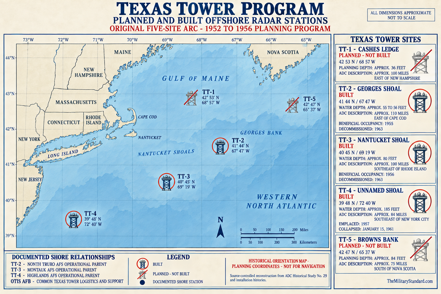
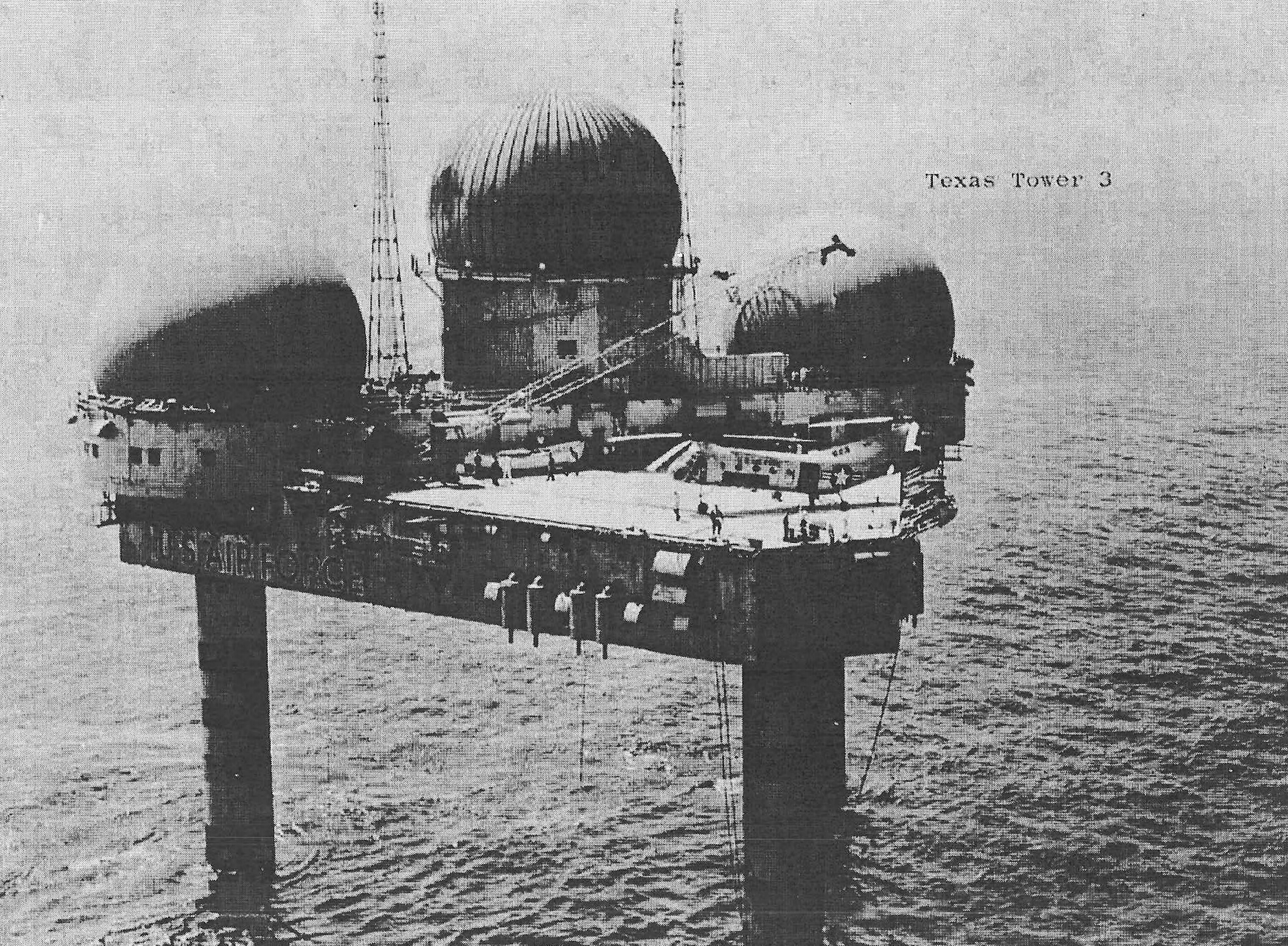
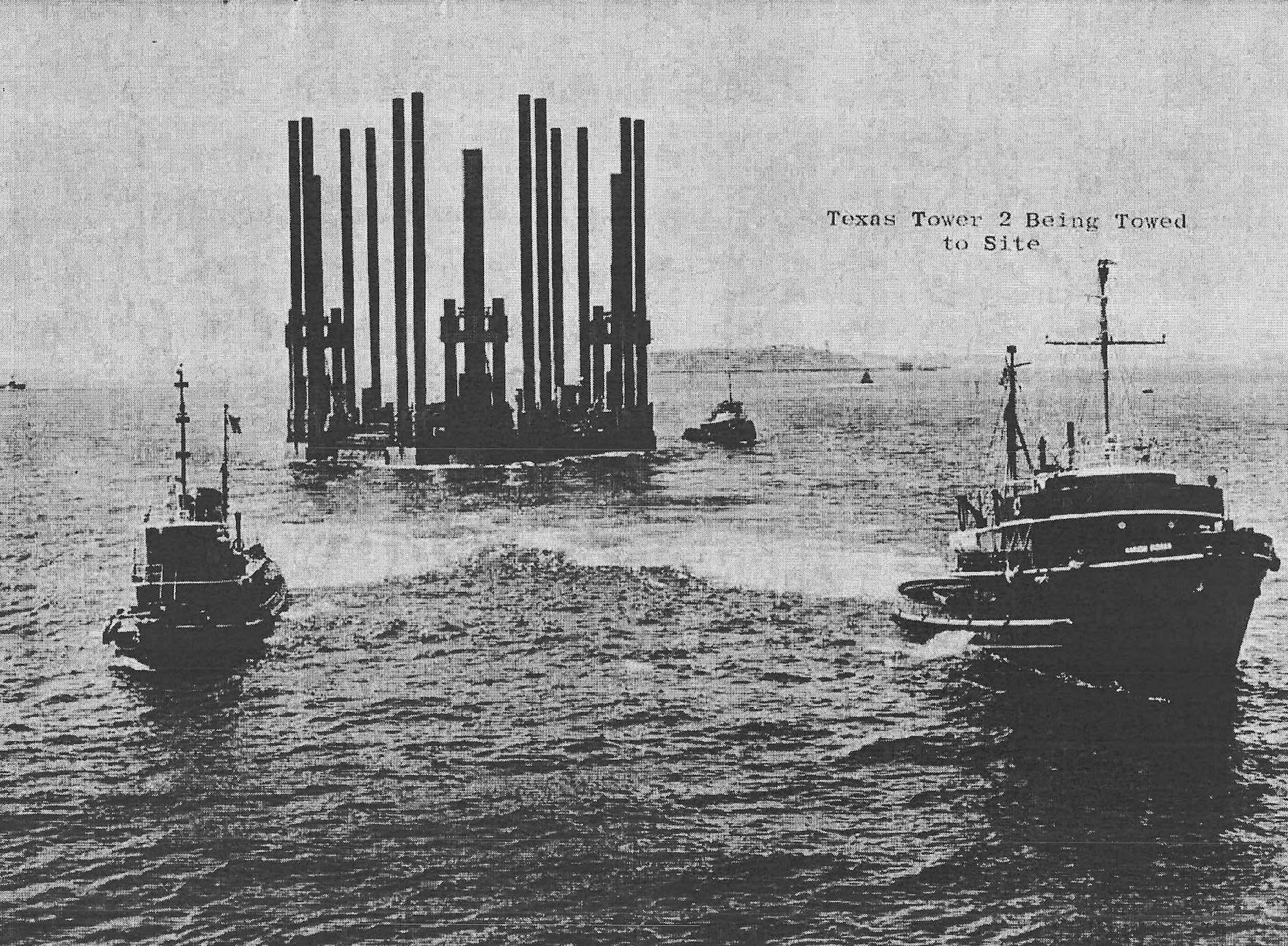
The record also requires separation from Texas Towers No. 1, 2, 3, and 5. TT-2 on Georges Shoal and TT-3 on Nantucket Shoal were completed installations with separate personnel, dates, units, equipment histories, and permanent identifiers. TT-1 at Cashes Ledge and TT-5 at Browns Bank were authorized or planned positions that never became operating platforms. Lessons, organizations, and program documents crossed the tower system, but each installation remains a distinct historical record.
The phrase Unnamed Shoal was the military site designation, not proof of a deeded Air Force parcel or a hydrographic feature whose entire area belonged to the station. The platform occupied a fixed point on the outer continental shelf, well beyond an ordinary county parcel. Public records reviewed do not establish a surviving Air Force boundary, current federal property polygon, or parcel acreage. The installation record therefore covers the platform, legs, immediate foundation and construction footprint, operational equipment, and direct support relationships rather than a speculative marine estate.
The 1962 federal decision in In re United States Air Force Texas Tower No. 4 described the position as about 80 miles east of Barnegat Inlet and 84 miles southeast of Coney Island. These orientation distances do not place the station inside a New Jersey municipality or county. They explain the selected state grouping while preserving the offshore character of the installation.
Location, Offshore Jurisdiction, and Coordinates
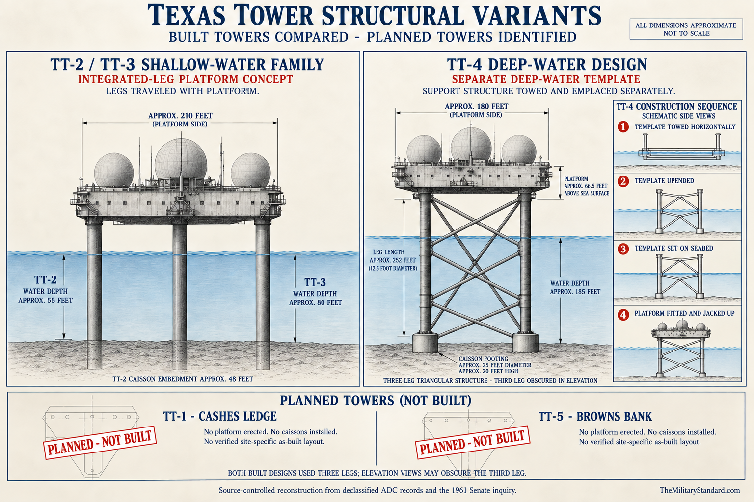
TT-4 stood in approximately 185 feet of Atlantic water on Unnamed Shoal. The deep position made it markedly different from TT-2 in about 56 feet and TT-3 in about 80 feet. Longer legs, additional underwater bracing, greater exposure, and a more difficult diving environment followed directly from that depth. The mission gained a far seaward vantage, but the structure also had to survive forces acting through a much taller and more flexible support system.
NOAA's National Data Buoy Center identifies station 44066 as Texas Tower #4 at 39.618 north latitude and 72.644 west longitude, approximately 75 nautical miles east of Long Beach, New Jersey. This is the representative coordinate retained in the master record because it is a current federal station listing tied explicitly to the tower name. NOAA reports no current data and says the buoy was recovered on April 16, 2024. The location therefore remains a federal reference point, not evidence that an active buoy now marks the wreck precisely.
Other published positions differ. A historical film catalog gives 39 degrees 48 minutes north and 72 degrees 40 minutes west, while general accounts describe the tower by distance and bearing from New Jersey or New York. Differences can arise from rounding, station reference conventions, separate buoy and wreck positions, navigation fixes, or transcription. This history does not silently average the coordinates or claim survey accuracy. A defensible wreck-center or debris-field map would require original construction control, Navy dive plots, and modern hydrographic or archaeological survey data.
The wreck lies at advanced technical-diving depth in open Atlantic conditions. USS Sunbird divers found twisted steel, broken windows, obstructed passages, large separated legs, and scattered framing in 1961. Those observations establish danger even before later corrosion, movement, burial, and fishing interaction are considered.
Strategic Requirement and Program Origins
The Texas Tower program grew from the early Cold War requirement to detect Soviet long-range bombers approaching the northeastern United States. Land radars provided an expanding continental screen, but radar line of sight left low-altitude gaps over the ocean. A hostile aircraft could remain below the horizon of a coastal station until it had crossed much of the distance to population centers, command installations, industrial regions, and Strategic Air Command bases. Air Defense Command therefore sought warning sensors farther seaward.
MIT Lincoln Laboratory examined fixed offshore radar stations while developing experimental air-defense and SAGE concepts. An August 1952 study proposed placing heavy long-range radar equipment on shallow Atlantic banks, using offshore petroleum engineering as a broad model. The proposed platform offered continuous presence and electrical capacity that radar picket aircraft and ships could not sustain at the same point indefinitely. Its purpose was not to replace every mobile sensor, but to add a stable outward layer to overlapping air-defense coverage.
The Air Force defined the warning mission and would operate the stations, while the Navy Bureau of Yards and Docks managed marine surveys, design, contracting, and construction supervision. Lincoln Laboratory and other technical organizations contributed network and equipment knowledge. This division of responsibility matched institutional specialties, yet it also divided authority over an unprecedented structure. Questions about who could certify strength, demand independent analysis, order repairs, or insist on evacuation later became central to the TT-4 inquiry.
Five tower positions entered the authorized program in 1953. TT-1 at Cashes Ledge, TT-2 at Georges Shoal, TT-3 at Nantucket Shoal, TT-4 at Unnamed Shoal, and TT-5 at Browns Bank formed a proposed Atlantic arc. The Navy completed common plans and specifications, conducted borings and surveys, and selected TT-2 as the prototype. Improvements in radar range, airborne warning, cost calculations, and operational priorities prevented TT-1 and TT-5 from being built, leaving three completed stations.
TT-4 was intended to watch approaches toward the New York-New Jersey region from a position beyond coastal radar horizons. Its tracks could support identification, interception, and wider regional warning through connections to the mainland air-defense system. The platform did not launch fighters or missiles. Its value lay in detection geometry, range and azimuth measurement, altitude reporting, communications, track continuity, and the time those functions could give commanders and interceptor forces ashore.
Design Changes for Deep Water
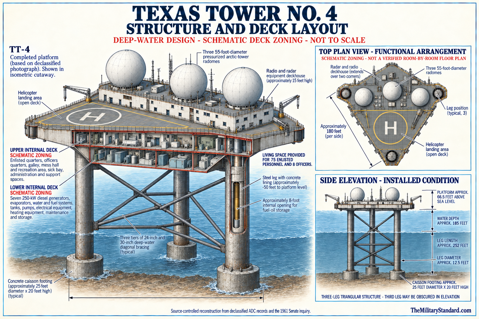
Texas Tower No. 4 used the familiar triangular platform and three-leg concept, but Unnamed Shoal forced major changes below the deck. The legs were much longer than those at the two northern towers, and the submerged structure incorporated pin-connected horizontal and diagonal bracing at several levels. Later engineering analysis described bracing levels near 25, 75, and 125 feet below the waterline. These members were intended to make the tall tripod act as a stable system while still permitting offshore assembly.
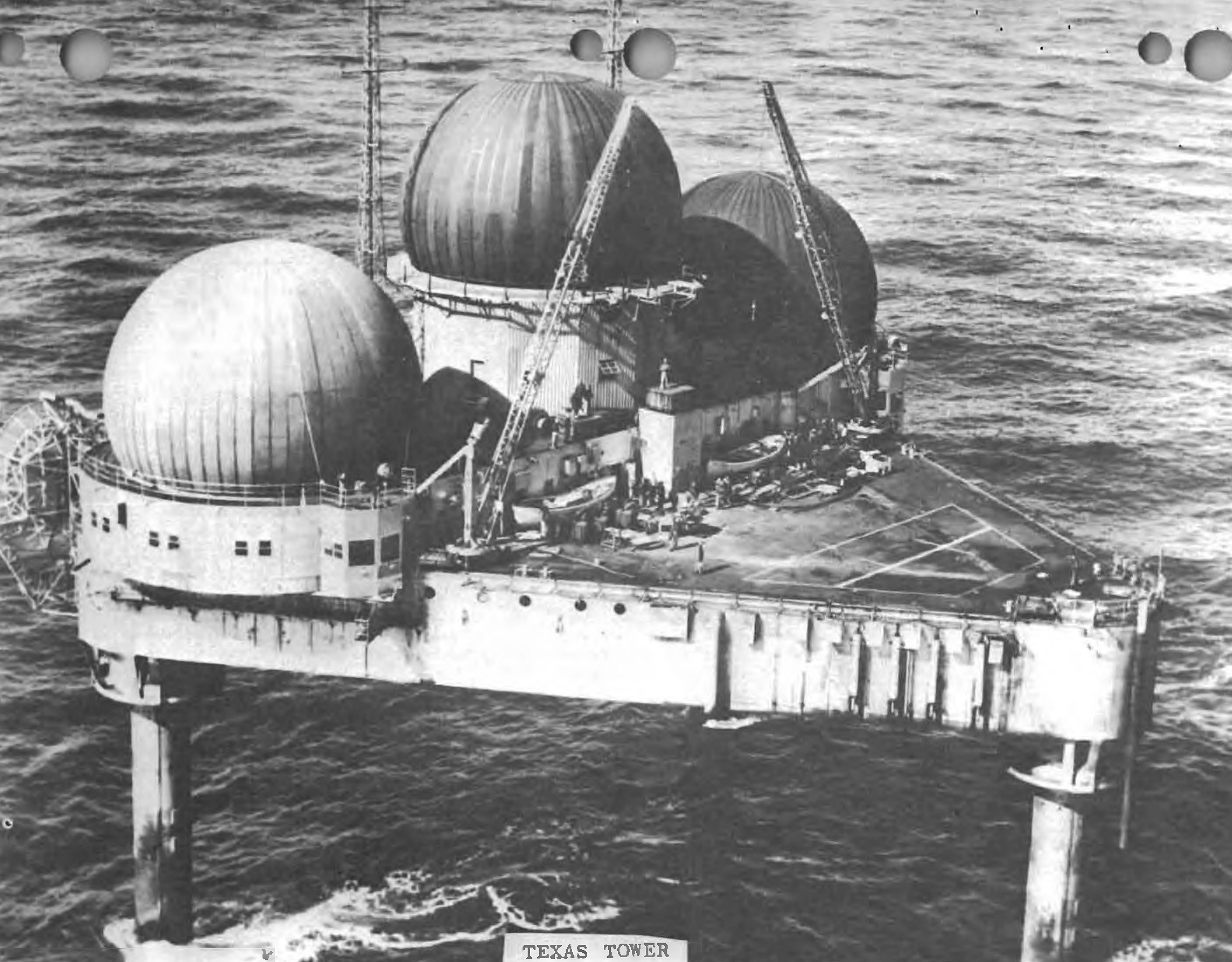
The completed platform was approximately 180 feet along each side and about 20 feet deep, with cropped corners and a raised central operating area. Three radar domes, communications antennas, a helicopter deck, and service equipment occupied the upper structure. The deck and enclosed spaces held operations rooms, machinery, generators, water plant, shops, storage, living quarters, galley, medical space, offices, and recreation facilities. The installation was an industrial building and barracks suspended above the sea, not simply antennas on a frame.
The foundation system used three large caissons seated on or embedded in the seabed. The 1962 federal court record described concrete caissons about 25 feet in diameter and 20 feet deep, with the steel legs fixed into them. The template and leg assembly could float during transport through buoyancy in cylindrical members, while the platform itself was also designed to float for towing. At the site, the pieces were brought together and the platform was jacked clear of the water.
Design criteria commonly discussed in the congressional record included winds near 125 miles per hour and breaking waves about 35 feet high. A design number is not a guarantee of survival, because actual resistance depends on load combinations, member condition, connections, construction tolerances, prior damage, soil response, and the direction and period of waves. The Senate subcommittee later found the original criteria inadequate for the location. It also doubted that the completed and repaired structure ever possessed the strength those criteria assumed.
The deep-water brace system created inspection and repair problems that did not exist in the same form above water. Divers had to find loose pins, damaged collars, cracks, or displaced members in cold, moving water with limited visibility and working time. A repair that restored local geometry did not necessarily restore the original global load path. The inability to measure remaining structural capacity reliably became as important as the visible damage itself.
Construction, Tow, and Emplacement
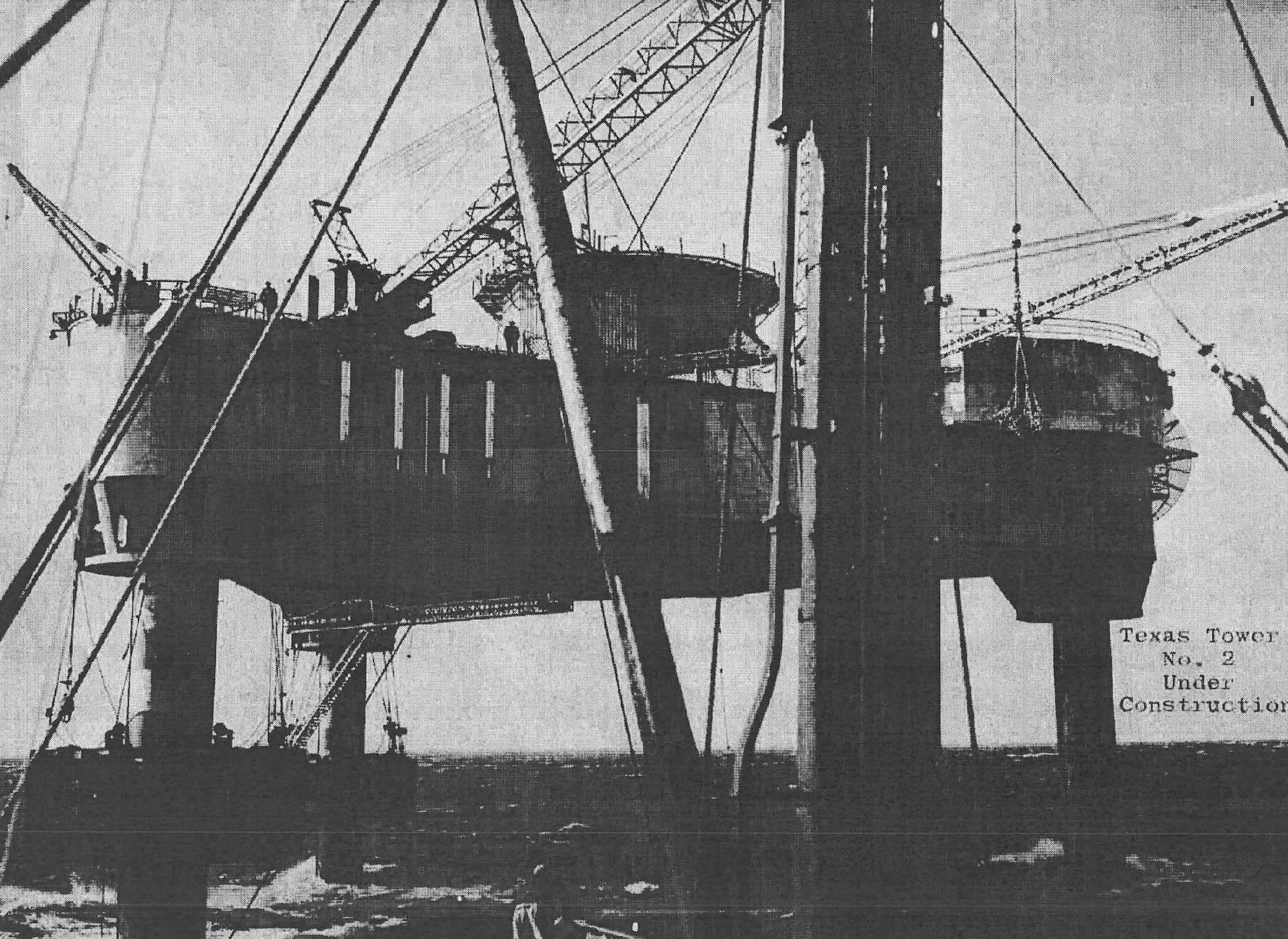
TT-4 construction began at South Portland, Maine, in late 1956. A joint venture of J. Rich Steers, Inc. and Morrison-Knudsen Company performed the construction work under Navy Bureau of Yards and Docks supervision, while Moran, Proctor, Mueser & Rutledge served as the principal design engineering firm. Contemporary and later photographs show the enormous platform and separate support structure in the former shipbuilding environment. South Portland, not Portsmouth Naval Shipyard, is the documented fabrication location.
The tower components were completed by mid-1957. Starting on June 28, the platform and supporting structure began the roughly 350-mile tow to Unnamed Shoal. The federal court record says two seagoing tugs moved the floating platform, which drew only about six or seven feet while under tow. Moving a structure designed for permanent installation exposed temporary transport configurations to Atlantic loads that differed from the final operating condition.
Two vital diagonal braces were lost during the June and July tow and emplacement process. The contractor, design engineers, and Navy representatives chose to repair or replace the damaged members at sea instead of returning the structure to shore for full reworking. Later official and engineering reviews treated this choice as a foundational weakness in the tower's history. Contemporary decision makers believed the field repair could be adequate, but the later Senate record and technical studies concluded that the original strength was not restored.
At Unnamed Shoal, crews positioned the three legs and template, established the caissons, floated the platform into place, and used jacks to raise it above the sea. The 1962 federal court decision gives July 8, 1957 as the date the platform was jacked clear of the water. This day-level construction milestone is more precise than general summaries that say only June or July. It does not mean the radar station was complete or operational on that date, because fitting-out, utilities, electronics, testing, and correction continued.
Air Defense Command gained beneficial occupancy in November 1957. Beneficial occupancy meant the Air Force could possess and use the structure while remaining work and correction continued; it was not the date of radar combat readiness. Official ADC data place manual radar operations in April 1959 and SAGE operation in April 1960. Treating the November 1957 turnover as the sole opening date would hide roughly seventeen months of installation, repair, testing, and technical preparation.
Radar, Communications, and Sage
The official ADC equipment table records an AN/FPS-20 search radar and two AN/FPS-6A height finders entering service at TT-4 in April 1959. Later unit compilations commonly identify the search set as AN/FPS-20A. The family relationship is clear, but the exact suffix should be tied to dated equipment records rather than assumed from photographs.
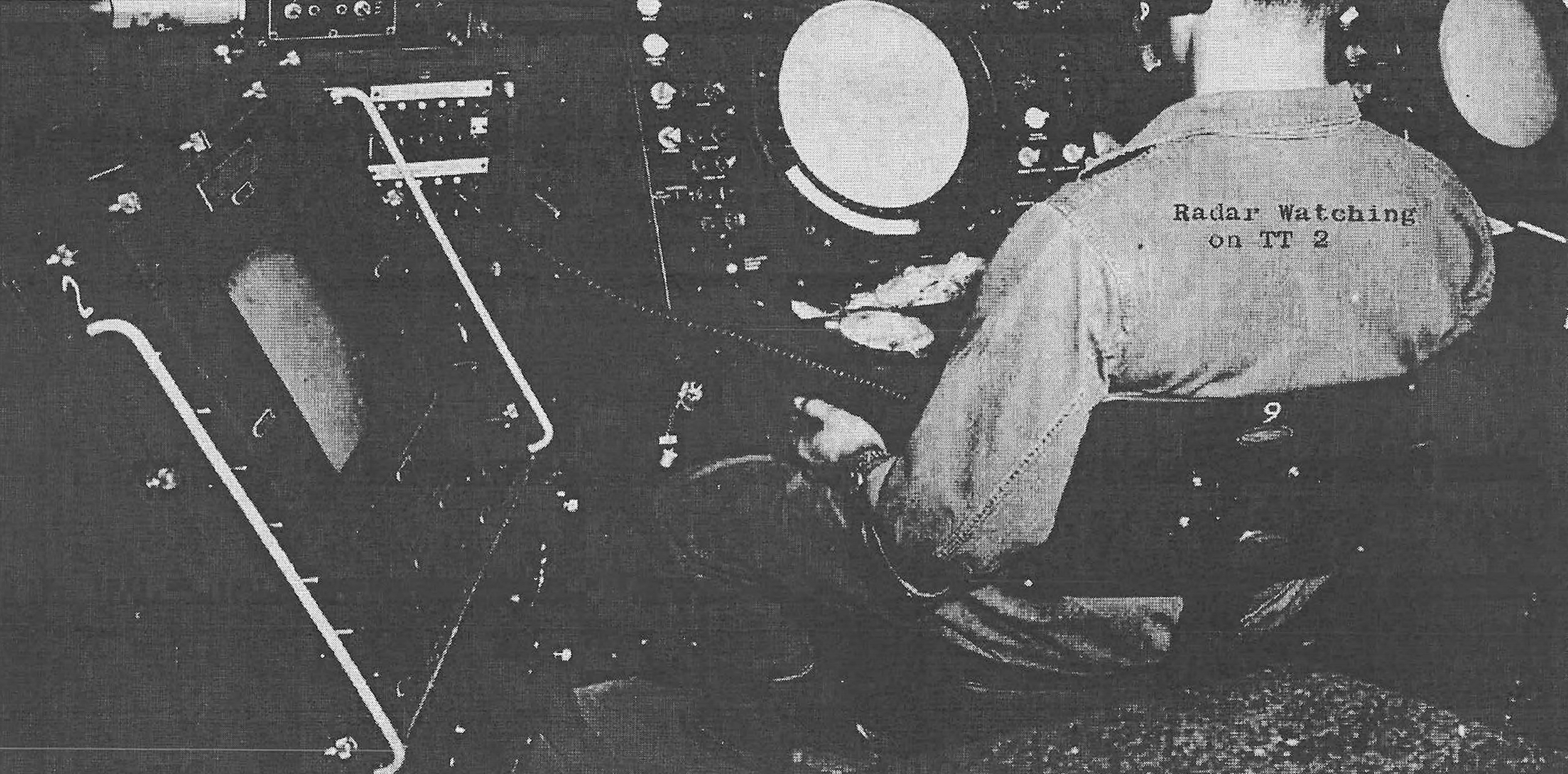
The search radar measured range and azimuth over a broad volume, while the height finders provided altitude information by mechanically scanning aircraft returns in elevation. Operators combined these measurements with identification, plotting, communications, and track-reporting procedures. A long-range search return without altitude or identification was incomplete for interception. The paired equipment gave the tower a genuine surveillance and weapons-control-support role even though fighter direction and final command authority remained part of the wider mainland network.
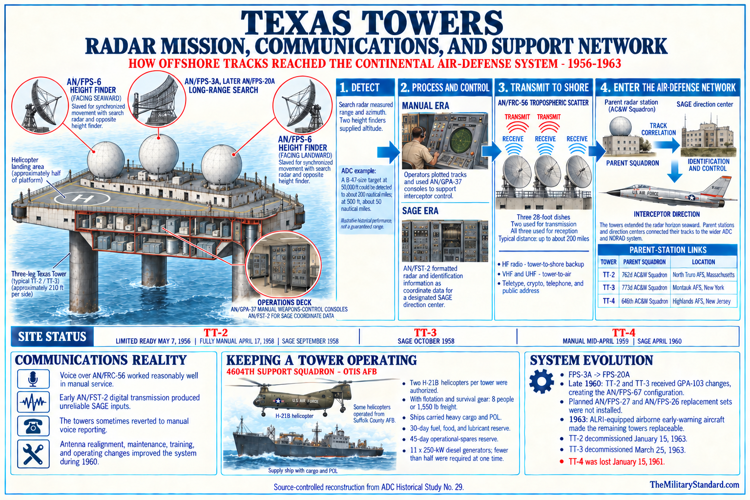
Three radomes protected the principal antennas from Atlantic wind and weather. The radomes did not eliminate vibration, salt contamination, maintenance, electrical faults, or the effects of platform motion on equipment and crews. Power came from a large diesel generating plant, and communications depended on radio and microwave links rather than a simple landline. Radar readiness therefore depended on fuel, parts, ventilation, dehumidification, antenna drive service, calibration, and reliable shore contact.
TT-4 began manual operation in April 1959. Operators observed and plotted targets locally, passed reports to shore, and maintained coordination through voice and data channels. The 646th Radar Squadron relationship connected the tower to Highlands Air Force Station and the New York air-defense sector. Manual service mattered in its own right; it was not merely a rehearsal for automation, because the tower contributed warning while SAGE integration was still being completed.
The tower entered SAGE operation in April 1960. SAGE combined radar inputs, digital computers, communications, direction centers, and weapons-control procedures into a regional system. TT-4 added a remote seaward sensor, but it did not house an entire SAGE direction center. Its observations moved through communications and organizational links to mainland centers where tracks could be correlated and interceptor action coordinated.
SAGE integration gave TT-4 greater network value just as structural concern was worsening. Technology and engineering readiness did not advance together. The station achieved its most sophisticated operational status only about five months before Hurricane Donna, and it remained fully connected for less than a year before destruction. That short overlap explains why TT-4 could be strategically useful yet operationally judged expendable once the structure itself became an unacceptable risk.
Organization, Command, and Support
The 646th Aircraft Control and Warning Squadron, later redesignated the 646th Radar Squadron (SAGE), was the principal operational parent organization associated with TT-4. The squadron's mainland station was Highlands Air Force Station, New Jersey, site P-9. Highlands supplied command, administration, personnel rotation, radar context, and the organizational link through which the offshore data entered the regional system. The tower crew was therefore part of a larger squadron mission rather than an isolated independent unit.
The 4604th Support Squadron at Otis Air Force Base provided the specialized support structure for all completed Texas Towers. Air Defense Command first shifted support responsibility from a North Truro organization to the 4604th Aircraft Control and Warning Squadron at Otis on October 8, 1956. The unit had been activated on September 28 and was redesignated the 4604th Support Squadron on December 31. Its mission included supply, transportation, maintenance coordination, administration, and the aviation and marine connections needed by offshore stations.
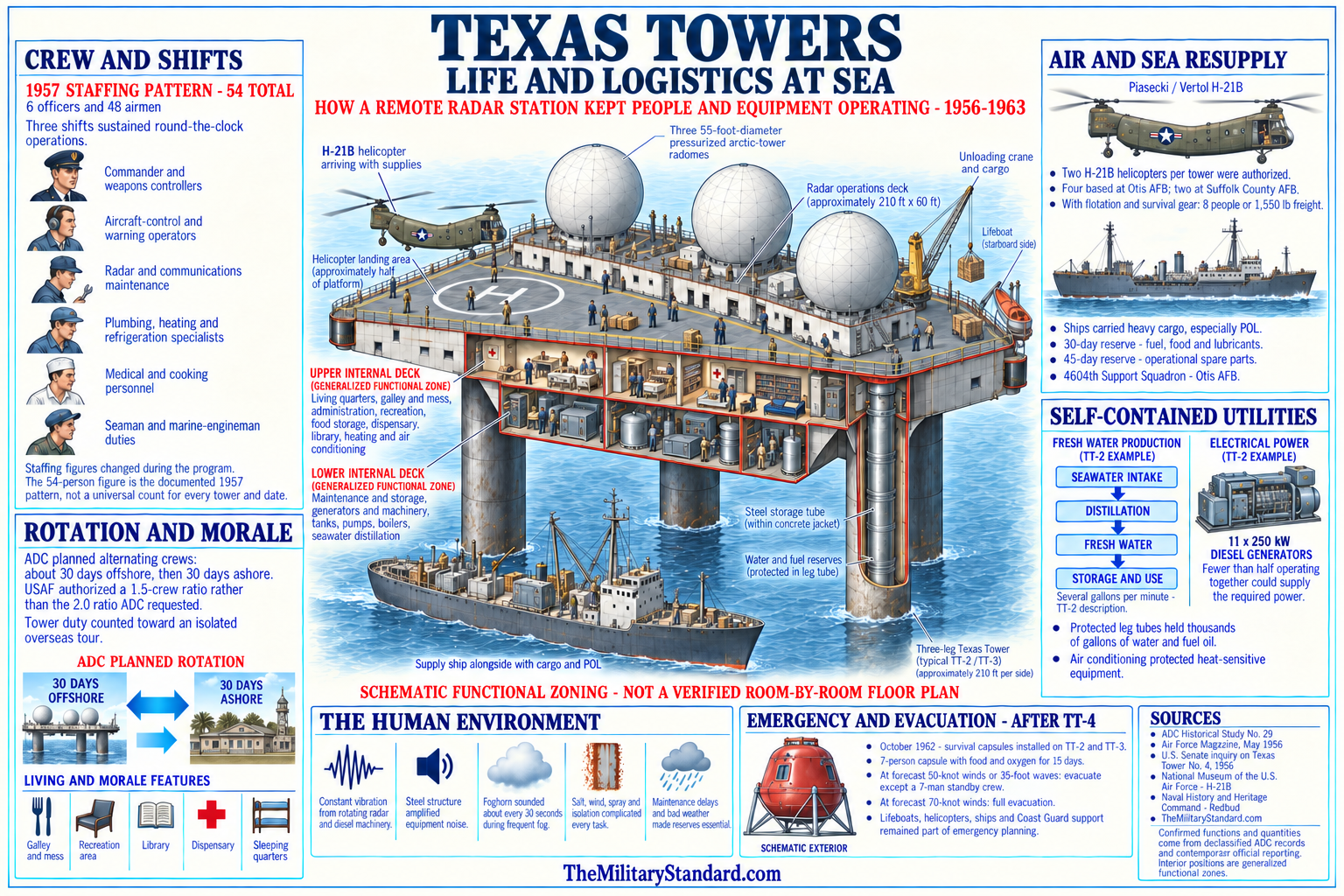
Helicopters were essential because routine personnel exchange, mail, light cargo, and urgent movement could not depend solely on vessels. Otis served as the main Texas Tower support base, while weather, aircraft availability, deck condition, weight, visibility, and sea state constrained each flight. Ships handled heavier loads, fuel, large components, and work that helicopters could not safely carry. The tower's impressive self-sufficiency was therefore measured in days or weeks, not permanent separation from shore.
The Navy Bureau of Yards and Docks remained central to structural engineering, construction supervision, and many repair questions. Civilian contractors supplied design, construction, diving, and repair expertise. Air Force organizations operated the mission and controlled personnel aboard. This shared system made sense for a novel offshore project, but responsibility could become fragmented when structural evidence did not fit a clear operational threshold.
TT-4's final complement was not the normal full operating force. After Hurricane Donna and the operational standdown, personnel were reduced to fourteen Air Force members and fourteen civilian repairmen. They formed a caretaker and repair party preparing or carrying out emergency structural work. Calling them simply the radar crew obscures why half the men were civilian specialists and why a damaged, partly inactive platform still held a substantial work force.
Facilities, Utilities, and Life Aboard
The tower's enclosed decks combined military operations with the necessities of an isolated settlement. Radar scopes, plotting equipment, communications racks, offices, and technical shops occupied spaces close to diesel generators, pumps, water treatment, storage, and living quarters. The crew ate, slept, trained, maintained equipment, and stood watches inside a structure that moved and vibrated. Every mission system shared the same dependence on a sound platform and functioning utilities.
Diesel generators supplied continuous power for radars, transmitters, antenna drives, lighting, heating, cooling, ventilation, galley equipment, pumps, and workshops. Fuel storage had to support long periods between deliveries and allow for storm delays. Distillation equipment converted seawater into fresh water, and tanks preserved reserve capacity. Failure of power or water production could force mission reduction or evacuation even if the radar electronics remained repairable.
Living spaces included sleeping quarters, mess and galley, sanitation, medical facilities, recreation areas, and administrative rooms. Programs attempted to reduce isolation with mail, films, reading material, communications, and scheduled rotation. Yet the environment produced seasickness, fatigue, noise, apprehension, and restricted movement. On TT-4, pronounced motion turned those ordinary offshore hardships into a continuing signal that the structure behaved differently from a stable land station.
The helicopter deck was a lifeline but not an all-weather escape system. Aircraft could operate only when wind, visibility, icing, deck movement, and fuel range permitted. Boats and ships also faced the same storm that endangered the platform, and transfers in heavy seas were hazardous. Evacuation planning therefore had to act before forecast conditions closed transportation options. Waiting until structural distress became unmistakable could make a technically authorized evacuation physically impossible.
Maintenance extended well beyond electronics. Crews fought salt corrosion, water intrusion, mechanical wear, vibration, loose fittings, leaks, structural movement, and damage to exterior antennas and platforms. Contractors and divers inspected members that operators could not see. This dependency meant that an Air Force commander might receive reports from operating personnel, Navy engineers, design consultants, construction firms, and dive teams, each using different measures of urgency.
The station's culture developed around competence and endurance, but the later nickname Old Shaky recorded more than routine humor. Operating personnel complained of abnormal motion as early as 1958. A nickname is not an engineering instrument, yet repeated lived experience can reveal a system problem before formal analysis defines it. The Senate inquiry treated the familiar motion as evidence that deserved stronger institutional response.
Structural Trouble, 1957 to 1960
TT-4 entered service with the consequences of the lost towing braces and the offshore repair decision already embedded in its support system. From the time of erection, personnel observed motion under conditions that should not have produced alarming behavior. Waves of moderate height could interact with the tall flexible structure in ways that made movement uncomfortable and difficult to interpret. The problem was not only whether one storm exceeded a design number, but whether prior damage and connection wear had changed how loads traveled through the tower.
Complaints by operating personnel became prominent in July 1958. Navy underwater surveys later that year found collar bolts at repaired connections sheared or loose. A defective connection weakened its immediate panel and transferred stress into members that had not been designed to carry the altered load alone. Repairs had to address both visible damage and a structural system whose actual stiffness and reserve strength were uncertain.
The construction contractor worked from late 1958 into May 1959, with at least six storm interruptions. Field repairs to collar connections were completed in May, and a June diver inspection certified the work. Reports said the effort stabilized tower motion for several months. Manual radar operations also began in this period, which meant structural repair and mission activation overlapped rather than occurring as neatly separated phases.
Four storms during the winter of 1959 and 1960 revived complaints of excessive movement. A February 1960 diver examination found substantial deterioration in pin-plate connections and loose pins. The condition was judged dangerous, and above-water X-bracing was treated as an emergency project to be installed before hurricane season. Engineers faced the difficult task of strengthening the tower without removing it from service or rebuilding the inaccessible underwater structure.
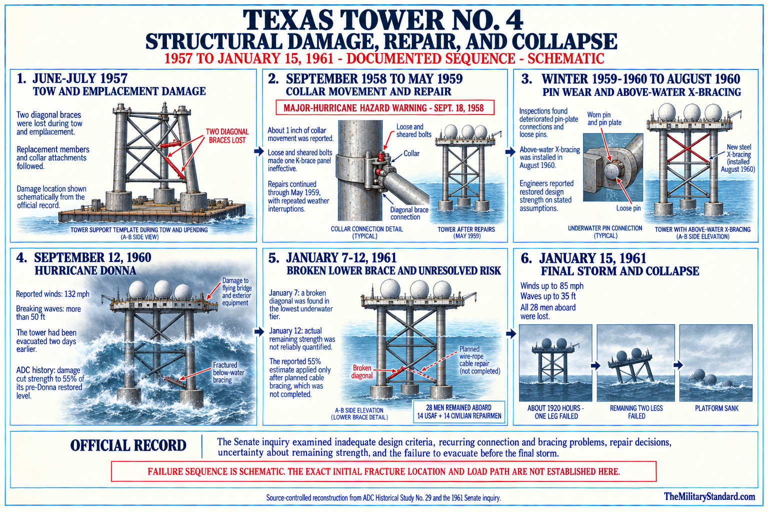
The X-bracing was installed in August 1960 between the legs above the water. Design engineers certified that the tower had been restored to original strength. Later critics argued that the additional members increased wave area and did not correct the underlying pin-connected bracing weaknesses. The conflict illustrates why a certification should be read with its assumptions, inspection limits, and subsequent evidence rather than treated as proof that the structure had become equivalent to an undamaged design.
Hurricane Donna and the Repair Program
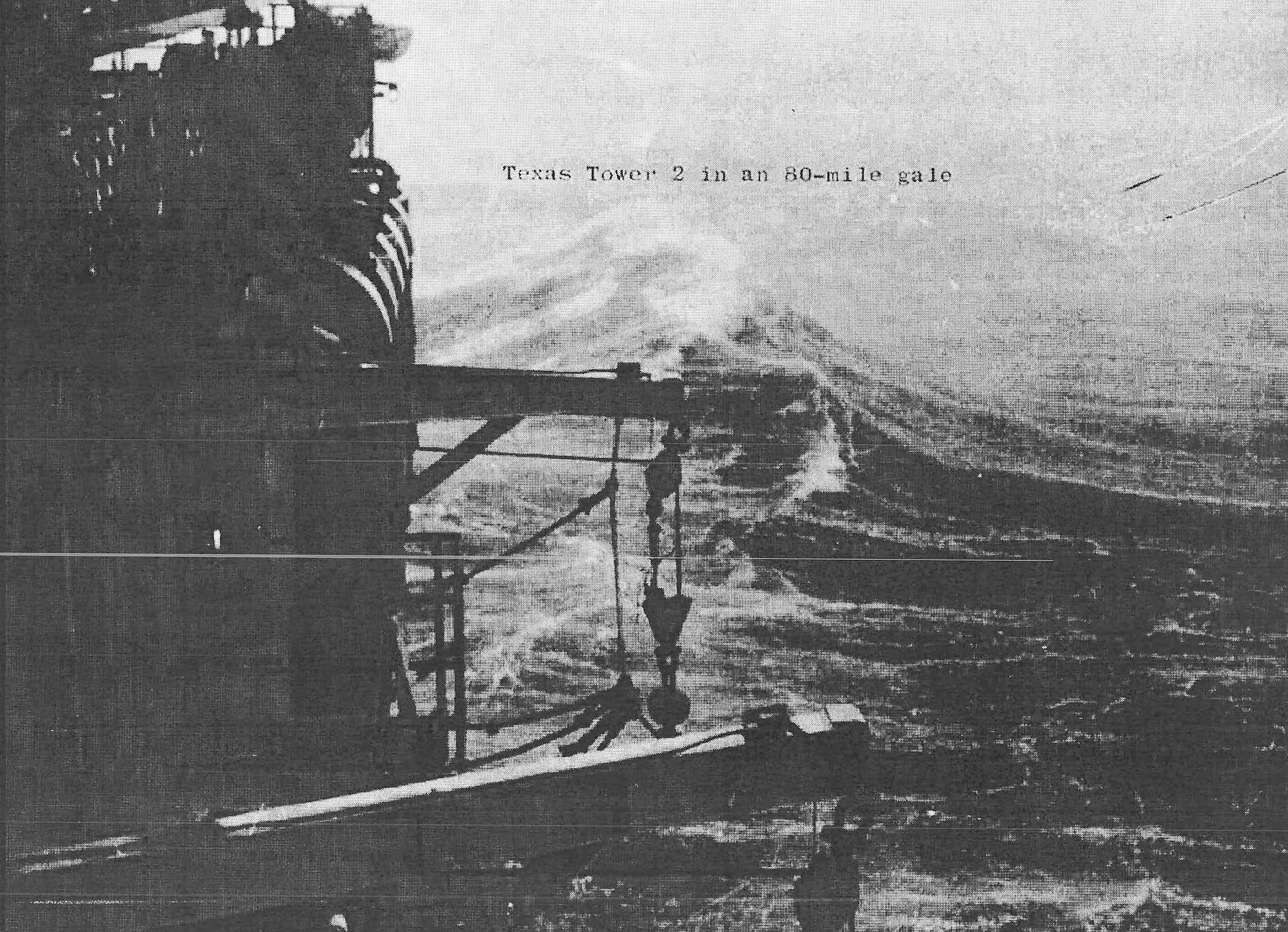
Hurricane Donna struck the TT-4 area on September 12, 1960 with forces reported above the tower's design assumptions. Later technical accounts cite gusts near 132 miles per hour and breaking waves exceeding 50 feet. The revolving maintenance platform, commonly called the flying bridge, was torn loose beneath the main structure. Exterior and communications equipment also suffered, and the tower underwent severe motion.
The tower survived Donna, but survival did not establish retained strength. Inspections found extensive damage above and below the waterline, including cracked or failed bracing on the A-B side. The operating mission stood down and the normal crew was removed, leaving a reduced maintenance party. A repair contract addressed the flying bridge and required further inspection of the supporting structure.
By November 1960, the flying bridge had been repaired and divers were examining the braces. The repair scheme called for three crossed wire-rope cable strands on the A-B side to substitute for the upper two damaged bracing panels. Planners initially assumed the lowest panel remained intact. This was an emergency stabilization method, not a restoration of all original steel members and connections.
A North Atlantic gale in December brought winds reported at 87 knots and high seas. It caused more damage before the cable scheme was complete. In January 1961, workers finished a sleeve repair near the 75-foot level, and installation of the wire-rope bracing began on January 1. Each new finding narrowed the margin between a damaged tower and the weather conditions it might encounter before full spring work.
On January 7, divers discovered a broken diagonal in the lowest underwater bracing tier, presumed to have failed during the December storm. That discovery invalidated the earlier assumption that the lower A-B panel remained intact. The Congressional chronology says that on January 12, Air Force officials, the construction contractor, and design engineers met in New York. The design engineer declined to state the remaining strength, although a statement suggested the tower with completed cable bracing and the broken lower diagonal might possess only about 55 percent of the original design strength.
Plans called for complete evacuation by February 1, followed by major renovation or other structural action. The fourteen airmen and fourteen civilian specialists remained to maintain the station and install temporary repairs before that date. A scheduled future evacuation did not answer the immediate question of what weather the damaged structure could survive. The three-day interval from the inconclusive January 12 meeting to the fatal storm became the central operational failure examined by Congress.
The Final Storm and Collapse
A winter storm developed over the Atlantic during January 14 and 15, 1961. Forecasts warned of high winds, while the actual site experienced strong wind, high seas, poor visibility, and icing conditions that constrained helicopters. Coast Guard recollection places winds up to about 85 miles per hour and waves near 35 feet; some later accounts give waves around 40 feet. These figures are approximate environmental reports, not a reconstructed load analysis at every moment.
During January 15, men aboard reported growing motion and structural noise. Later narratives place a particularly loud sound in the late morning, consistent with another failure but not directly identifying which member broke. Communications continued while Air Force authorities considered evacuation. By the time a removal decision was made late in the afternoon, conditions prevented helicopters from safely reaching and clearing the deck.
Surface vessels and aircraft moved toward the station, but distance and weather imposed unavoidable travel time. The carrier USS Wasp and destroyers joined the emergency response, while other ships and aircraft searched the approaches. Radio traffic conveyed worsening distress. Around 7:20 to 7:28 p.m., the radar image and communications from TT-4 disappeared as the platform collapsed into the Atlantic.
The official congressional chronology gives approximately 7:25 p.m. The 1962 federal court decision also uses about 7:25. USS Sunbird divers later recovered a suitcase clock stopped at 7:28, offering a physical but not absolute indication of collapse time. Some contemporary and secondary accounts use 7:20 or 7:33. The history retains 7:25 as the official approximate time and 7:28 as the strongest artifact-based refinement rather than pretending the sources are identical.
No organized abandonment succeeded, and no survivor was found. The platform descended into 185 feet of water with all twenty-eight men. The main structure settled with two corners at or near the seabed and the third elevated within the wreckage. Radar domes, masts, exterior fittings, boats, fuel, machinery, and interior spaces were crushed, torn away, or submerged in seconds.
The tragedy was not simply the result of a large storm striking a sound station. Known transport damage, connection problems, repeated abnormal motion, incomplete emergency repairs, Hurricane Donna damage, the December gale, the January 7 brace discovery, and the absence of a reliable strength assessment formed a cumulative chain. The storm supplied the final load, but the investigations focused on why people remained on a platform whose capacity could not be stated.
Search, Recovery, and Wreck Investigation
Rescue efforts began immediately, although aircraft and ships initially had to fight the storm that had destroyed the tower. USS Wasp, destroyers, Coast Guard resources, Air Force aircraft, and civilian divers searched the sea for rafts, wreckage, survivors, and bodies. The first hours still allowed hope that an air pocket or floating craft might contain survivors. Debris, fuel odors, damaged boats, and a body on the surface soon showed the violence of the collapse.
The January 16 congressional chronology records one military body recovered from the sea and a second body sighted but not recovered at that time. Contemporary reporting identifies the recovered man as Master Sergeant Troy F. Williams. Later memorial and diving accounts state that only two bodies were ultimately recovered from the twenty-eight victims, although the exact sequence and identification of the second recovery varies among summaries. The history therefore does not convert an early search report into a complete recovery roster.
The Navy assigned USS Sunbird, a submarine rescue vessel equipped for deep diving, to investigate the wreck and continue the search. Commander Alan B. Crabtree's later professional account describes ice, current, poor weather, deep water, entanglement hazards, damaged passageways, and the physical strain of repeated dives. Sunbird's work was not a recreational wreck survey. It combined possible body recovery, structural reconnaissance, evidence retrieval, and safe conduct of divers in a lethal industrial ruin.
Divers found that the platform had not disintegrated completely. The B and C corners rested near the bottom, while the A corner remained roughly 100 feet above the seabed. The shallowest portions of the main structure lay about 65 feet below the surface, and the top of one radio mast was reported near 25 feet. Exterior doors, hatches, and windows were blown out; much of the central radome house was gone; passages were blocked by furniture, wiring, machinery, and broken steel.
Sunbird crews completed about one hundred dives by February 1. They recovered documents and personal effects, including a suitcase with a clock stopped at 7:28. They found large separated structural members and eventually located the leg field about 200 yards from the main wreck on a bearing reported as 070 degrees true. The B and C legs could be identified, and the B leg was broken just above its bottom footing, which remained in place.
The dive account also explains why a comprehensive body recovery was impossible. Penetration required movement through sharp, unstable, dark, debris-filled compartments at extreme depth, with limited bottom time and decompression obligations. Sections could shift, and a diver's air hose or lifeline could catch on wreckage. The decision to end intensive interior searching reflected risk to the living as well as respect for the dead.
Navy observation contributed evidence for the Air Force board, the Senate inquiry, and later structural analysis, but the dives could not reconstruct every failure in sequence. The separated legs, bracing field, platform attitude, and visible fractures showed a catastrophic system collapse. Determining which connection failed first and how dynamic loads propagated required drawings, testimony, inspection reports, weather data, and engineering models in addition to underwater observation.
The Twenty-Eight Men
Fourteen Air Force personnel died aboard TT-4. They were Captain Gordon T. Phelan, Master Sergeant Roald Bakke, Master Sergeant Troy F. Williams, Technical Sergeant Bishop O. Foster, Technical Sergeant Donald R. Wait, Staff Sergeant Kenneth H. Green, Staff Sergeant Wilbur L. Kovarick, Staff Sergeant Harry M. Shaffer, Airman First Class William E. Krause, Airman First Class Larry V. Woolford, Airman Second Class Domenic V. Giurastante, Airman Second Class Leland H. Jones, Airman Second Class Louis M. Laino, and Airman Second Class David K. Parker.
Fourteen civilian repairmen also died. They were David W. Abbott, Vincent G. Brown, Samuel Buccheri, Chester J. Cudnik, Thomas J. Evans, Aram Haroutunian, William C. Ide, Milton D. Leo, Raymond D. Martell, Anthony Opalka, Edward T. Robertson, Henry Schutz, William Smythe, and Vincent A. Yavoroski. Their presence reflects the unfinished structural emergency: the tower carried a repair force equal in number to its reduced military complement.
The names above are reconciled against the Texas Towers memorial plaque, which includes additional men who died in other tower-related accidents. Captain Lewis V. Barker and Chief Warrant Officer Owen L. Morgan died in a TT-2 helicopter accident on November 24, 1959; Staff Sergeant John R. Bradstreet was lost from TT-3 on March 6, 1959; and Arsen S. Haroutunian died during TT-2 construction on August 16, 1955. They belong to the wider program memorial but not to the January 15 TT-4 casualty count.
Captain Phelan commanded the reduced party. The airmen maintained communications, utilities, readiness, safety, and the military installation while civilian specialists performed structural repair work. Their exact duties differed, but all were exposed to the same narrowing evacuation window. The Senate later described them as men who died at their posts in national service, a recognition that joins civilian and military labor rather than treating the repairmen as peripheral contractors.
The small number of recovered remains shaped remembrance. For most families there was no conventional burial of an identified body, and the wreck itself became a grave site. That fact changes how historical access should be discussed. The value of photography, archaeological documentation, and technical research must be balanced against danger, legal restrictions, artifact ownership, and respect for a place holding the unrecovered dead.
Air Force Fact-Finding and Senate Inquiry
The Air Force convened a board of officers immediately after the collapse. Congress also opened a broader inquiry because the tragedy involved design, contracting, construction, inspection, operational authority, and twenty-eight deaths. The Senate Committee on Armed Services Preparedness Investigating Subcommittee held public hearings on May 3, 4, 10, 11, and 17, 1961. Testimony and exhibits examined the program from the 1952 concept through the January 12 meeting and final storm.
The Senate inquiry did not reduce the failure to one broken brace. It examined original environmental criteria, the untried deep-water erection method, the two braces lost during towing, at-sea repairs, loose and sheared collar bolts, repeated motion, the 1959 certification, the 1960 deterioration, emergency X-bracing, Hurricane Donna, underwater damage, cable repair, and the broken lower diagonal found on January 7. This chronology made organizational judgment inseparable from structural mechanics.
The subcommittee concluded that the design criteria were inadequate for the site and that the tower probably had never met even the intended design strength. It assigned responsibility for design deficiencies to the Navy Bureau of Yards and Docks and Moran, Proctor, Mueser & Rutledge, and it criticized construction and repair decisions involving the responsible organizations. These findings should be attributed to the subcommittee because they emerged from an adversarial investigation rather than a universally accepted single-cause analysis.
The subcommittee placed substantial blame for the loss of life on the Air Force. In its view, the using service failed to obtain a timely independent evaluation of remaining strength and failed to evacuate completely while transportation was still possible. The design engineers had not supplied a usable relationship between known damage and forecast weather during the four months after Donna. Congress argued that independent experts not involved in design, construction, or repair should have assessed the danger.
One especially important management lesson concerned uncertainty. On January 12, the tower's remaining capacity could not be stated, and the proposed cable repair had not restored the broken lower bracing panel. Uncertainty was treated operationally as a reason to continue planned work until a defined limit was crossed, even though no reliable limit existed. The Senate's criticism effectively reversed that logic: when failure would be catastrophic and evacuation options were weather-dependent, inability to establish safety should itself have triggered removal.
The inquiry's cutoff date was January 12, three days before the collapse. This choice concentrated responsibility on what decision makers knew before the storm rather than allowing hindsight about the exact January 15 wave sequence to dominate. The committee did not need to prove the first member that fractured in order to evaluate whether continued occupancy was reasonable. That distinction remains important in reading the hearing record.
Later engineering papers revisited TT-4 with structural models and offshore experience unavailable in 1961. A 2002 Offshore Technology Conference failure analysis emphasized the compromised A-B bracing, loose pin connections, storm damage, and questionable effect of added X-bracing. Such retrospective work helps explain collapse mechanics, but it should not erase the contemporary evidentiary limits or be mistaken for the Senate report itself. The history keeps official findings, witness testimony, and later analysis in separate categories.
Legal Aftermath
The collapse generated claims by families and disputes among the United States, contractors, and design firms. On July 18, 1961, the United States petitioned in federal court for exoneration from or limitation of liability as owner of what it called a public vessel. Claims filed in the proceeding exceeded five million dollars by early 1962. The government theory depended in part on the tower's having floated during transport.
In In re United States Air Force Texas Tower No. 4, decided March 9, 1962, the federal district court held that the completed fixed tower was not a vessel for purposes of the maritime limitation statute. The platform and template had floated to the site, but the assembled station was intended as a permanent and integral radar installation. The court dismissed the government's limitation petition. This decision supplies valuable construction facts while also defining the installation's legal character.
Related wrongful-death litigation included Abbott v. United States and Williams v. Moran, Proctor, Mueser & Rutledge. Those cases addressed jurisdiction, government responsibility, contractor allegations, and procedural questions arising from the same casualty. A history of the installation need not resolve every later claim to show the significance of the litigation: TT-4 challenged the boundary among public works, offshore structures, vessels, federal immunity, contractor duty, and compensation for civilian deaths.
TT-4 was a fixed military installation after erection, even though major components were temporarily buoyant during construction. Its later wreck is not transformed into a shipwreck in the operational sense merely because admiralty courts considered maritime statutes. Cultural-resource and dive literature may use the word wreck naturally, while installation history retains its Air Force base identity.
Role in the Wider Military Network
TT-4 occupied one layer of a continental system rather than operating as a self-contained fortress. Its outward search radar extended detection eastward; height finders supplied altitude; identification and communications procedures passed usable tracks ashore. Highlands Air Force Station and the 646th Radar Squadron connected those observations to the New York-area air-defense organization. Direction centers, fighter squadrons, communications nodes, coastal radars, and command staffs converted warning into coordinated action.
SAGE strengthened this relationship by automating parts of track transmission, correlation, display, and weapons direction. MIT Lincoln Laboratory's computer and communications work made remote radar inputs valuable across a larger region. TT-4 did not replace human operators or local reporting, and it did not become a SAGE direction center. It supplied a seaward sensor stream whose value depended on successful integration with many land-based elements.
Otis Air Force Base and the 4604th Support Squadron formed a parallel logistics network. Personnel rotation, helicopter support, supply, administration, equipment movement, and emergency response tied the New Jersey tower to Massachusetts. Navy engineering and ships added another service relationship, while civilian construction and diving firms supplied specialized knowledge. This network enabled the mission but also distributed responsibility across geographic and institutional boundaries.
The tower supplemented radar picket aircraft, Navy ships, and mainland stations rather than replacing all of them. Fixed radars offered continuous heavy-power operation and a stable geographic reference, but they could not move around weather or structural danger. Aircraft could reposition and extend low-level coverage, but required crews, fuel, maintenance, and rotation. Later Airborne Long Range Input EC-121 aircraft helped make the remaining towers less necessary by offering flexible seaward data for SAGE.
TT-4's brief SAGE period shows the rapid pace of air-defense change. The platform concept originated when a fixed offshore station seemed the practical way to carry large radars beyond the coast. By 1961, improved land radars, airborne warning, communications, and changing threat analysis were altering that calculation. The collapse accelerated scrutiny, but the program was already being evaluated against newer systems, high maintenance cost, and danger to personnel.
Program Aftermath
The TT-4 disaster forced immediate examination of TT-2 and TT-3. Authorities reviewed structural condition, evacuation planning, weather thresholds, support arrangements, and the cost of keeping crews offshore. The remaining stations did not fail in the same way, but TT-4 demonstrated that an uncertain marine structure could turn a radar mission into a mass-casualty risk. Continuing operation now required a stronger justification than strategic usefulness alone.
TT-2 remained in service until January 15, 1963, and TT-3 until March 25, 1963. The Joint Chiefs of Staff directed TT-2's immediate inactivation and retained TT-3 only temporarily while Airborne Long Range Input approached readiness. Severe seabed scour and evacuation at TT-3 in November 1962 added another structural warning. The transition therefore combined the TT-4 lesson with specific defects, cost, and technological replacement.
Demolition and salvage of the surviving towers created further engineering challenges. TT-2 was cut from its legs in 1963, sank during the attempt, and had to be recovered and scrapped. TT-3 was filled and sealed with urethane foam before explosives separated it in August 1964; it resurfaced and was towed away. These operations showed that the platforms were difficult to remove even under controlled conditions and after their radar missions ended.
The canceled TT-1 and TT-5 projects acquired added historical meaning after the collapse. They were not half-built towers awaiting completion, but planned sites whose abandonment avoided additional fixed offshore exposure.
The wider lesson extended beyond air defense. TT-4 became a case study in offshore structural design, temporary construction loads, pin connections, cumulative damage, inspection, contractor-government responsibility, emergency repair, and evacuation under uncertainty. Later offshore engineering benefited from more developed standards, fatigue analysis, environmental modeling, underwater inspection, and explicit risk management. The tower remains historically useful because technical failure and organizational decision-making cannot be separated.
Current Wreck, Environment, and Access
The main platform and large structural components remain on the Atlantic seabed. Sunbird's 1961 survey documented a recognizable platform with parts at varying depth and separated legs nearby. Subsequent corrosion, storms, sediment movement, fishing gear, biological growth, and human visitation have altered the site. Public sources located do not provide a complete modern multibeam map, artifact inventory, or condition assessment sufficient to define every surviving element.
NOAA station 44066 preserves the Texas Tower #4 name and gives the representative coordinate used in the master record. The National Data Buoy Center status report says the buoy was recovered on April 16, 2024 and currently has no reports. A maintenance schedule may describe future service activity, but it does not establish that an observing hull is presently on station. Current use is therefore stated as submerged wreck and grave site, with an inactive or recovered NOAA buoy reference rather than an active weather station.
The New York State offshore cultural-resources study identified TT-4 as a Cold War wreck with potential to illuminate a dominant national historical theme. That finding does not by itself assign legal protection, ownership, or eligibility under the National Register of Historic Places. It does establish that the wreck has archaeological and interpretive value beyond a recreational dive destination. The structure embodies radar history, federal engineering, labor, disaster, and memorial significance in one site.
The wreck is an advanced technical dive, not a public base tour. Depth near 185 feet, decompression, Atlantic current, cold, visibility, entanglement, sharp corroded steel, overhead penetration, and distant emergency support create severe hazards. Historic accounts of Navy divers operating with a dedicated rescue vessel should not be read as evidence that an ordinary expedition can duplicate the work.
Memorialization and Historical Legacy
Veterans, families, radar historians, divers, and local organizations preserved TT-4 when official attention receded. Photographs, newsletters, rosters, oral histories, and personal records kept the twenty-eight names connected with the station. The Texas Towers Association and Radomes archives became important finding aids, especially for images and recollections absent from concise official summaries. Their material is used with source labels and cross-checking rather than treated as a replacement for government records.
A Texas Towers memorial plaque was dedicated and placed on July 14, 1999. It honors the twenty-eight men lost aboard TT-4 and also identifies four other deaths associated with the wider tower program. The distinction matters: the memorial is broader than the January 1961 casualty roster. Its placement made the program's human cost visible even though the principal grave lies far offshore and most remains were never recovered.
Otis Memorial Park at Joint Base Cape Cod preserves the Texas Tower story near the support base from which the 4604th sustained the platforms. Memorialization at Otis connects radar operators, aircrews, support personnel, contractors, and families to the logistics center of the program. It also corrects the impression that the towers were isolated curiosities with no mainland community. The stations depended on people and infrastructure across New England and New Jersey.
In 2011, national attention marked the fiftieth anniversary and brought presidential recognition to the families. The long delay itself is historically significant. The dead were performing national-defense work, but the accident occurred outside combat and involved an equal number of civilians, making traditional military commemoration less automatic. Modern remembrance increasingly treats them as a single duty party lost in public service.
The New Jersey Maritime Museum and other interpretive organizations have presented the tower as a regional maritime and Cold War tragedy. Divers have supplied images that show how a massive air-defense station became a deep-water ruin. Responsible interpretation must resist two distortions: romanticizing the wreck while neglecting the men, and reducing the entire installation to its final minutes while neglecting its technology, labor, and operational mission.
Chronology
- August 1, 1952 MIT Lincoln Laboratory outlined a fixed offshore radar-platform concept for extending seaward warning.
- August 1952 Early planning compared fixed platforms with radar picket ships and other approaches to low-altitude warning.
- 1952 through 1953 Air Force, Navy, and technical staffs refined mission, manning, communications, and site concepts.
- Autumn 1953 The Air Force authorized a five-tower program that included Unnamed Shoal as TT-4.
- November 16, 1953 Air Force planning guidance set implementation assumptions for the offshore radar system.
- January 1954 Five Atlantic positions remained in the approved concept.
- March 1954 The Navy Bureau of Yards and Docks completed common plans and specifications.
- June 1954 BuDocks design work and contractor relationships for the tower program were formalized.
- Summer 1954 Marine surveys, borings, and feasibility studies examined proposed offshore sites.
- October 1954 A feasibility report supported fixed-tower construction while identifying demanding marine conditions.
- December 1954 TT-2 was selected as the first tower and prototype for later work.
- November 1955 Contracts and construction arrangements for TT-3 and TT-4 were advancing under Navy supervision.
- 1955 through 1956 Experience constructing and emplacing TT-2 generated lessons for later towers.
- September 28, 1956 The 4604th Aircraft Control and Warning Squadron activated at Otis Air Force Base for tower support.
- October 8, 1956 Support responsibility transferred from the North Truro organization to the 4604th at Otis.
- December 1956 TT-4 construction began at South Portland, Maine.
- December 31, 1956 The Otis organization was redesignated the 4604th Support Squadron.
- Early 1957 J. Rich Steers and Morrison-Knudsen continued platform and support fabrication under Navy supervision.
- May 1, 1957 A Woods Hole Oceanographic Institution photograph documents TT-4 construction at South Portland.
- June 28, 1957 The completed components began their tow from South Portland toward Unnamed Shoal.
- June through July 1957 Two diagonal braces were lost during towing and emplacement operations.
- June through July 1957 The responsible organizations chose field repairs instead of returning the structure to shore.
- July 8, 1957 The platform was jacked above the water on its three legs at Unnamed Shoal.
- Summer and autumn 1957 Contractors fitted utilities, machinery, communications, and radar systems and corrected construction problems.
- November 1957 TT-4 was completed sufficiently for beneficial occupancy and turned over to the Air Force.
- Late 1957 through 1958 Air Force and contractor personnel occupied, tested, repaired, and prepared the station for operations.
- July 1958 Operating personnel made prominent complaints about excessive or unusual platform motion.
- Late 1958 Navy underwater surveys found collar bolts at repaired connections sheared or loose.
- Late 1958 through May 1959 Contractors repaired connections while storms interrupted the work at least six times.
- April 1959 ADC records manual operation and activation of AN/FPS-20 search radar and two AN/FPS-6A height finders.
- May 1959 Field repairs to collar connections were completed.
- June 1959 A diver inspection certified the completed repairs.
- 1959 Repairs reduced movement for several months while manual radar service continued.
- Winter 1959 to 1960 Four successive storms renewed concern about tower stability.
- January 1960 Operating personnel again reported excessive movement.
- February 1960 Diver examination found deteriorated pin-plate connections and loose pins.
- February 1960 Authorities judged the condition dangerous and ordered emergency above-water X-bracing before hurricane season.
- April 1960 TT-4 became operational in the SAGE network.
- August 1960 Contractors installed above-water X-bracing between the legs.
- August 1960 Design engineers certified that the tower had been restored to original strength.
- September 12, 1960 Hurricane Donna struck with reported wind and wave forces above design assumptions.
- September 12, 1960 Donna tore away the flying bridge and damaged superstructure, antennas, and underwater bracing.
- September 1960 The operating mission stood down and personnel were reduced.
- Autumn 1960 Fourteen Air Force personnel and fourteen civilian specialists remained as the caretaker and repair party.
- November 1960 The flying bridge was repaired and divers reported extensive damage above and below water.
- November 1960 A wire-rope cable scheme was selected to replace the upper two damaged A-B bracing panels.
- December 1960 A North Atlantic gale with reported 87-knot winds and high seas struck the damaged tower.
- January 1961 Workers completed a sleeve repair near the 75-foot bracing level.
- January 1, 1961 Installation of crossed wire-rope bracing began on the A-B side.
- January 7, 1961 Divers found a broken diagonal in the lowest underwater tier.
- January 12, 1961 Air Force, contractor, and design representatives met in New York about remaining strength.
- January 12, 1961 The design engineer declined to state the tower's remaining capacity in light of known damage.
- January 14, 1961 A winter storm developed and began affecting the offshore station.
- January 15, 1961 Wind, waves, icing, motion, and structural noise worsened while evacuation was considered.
- Late afternoon, January 15, 1961 Evacuation was authorized too late for helicopters to operate safely in the storm.
- Approximately 7:25 p.m., January 15, 1961 TT-4 collapsed, killing all fourteen airmen and fourteen civilian repairmen.
- 7:28 p.m., January 15, 1961 A suitcase clock later recovered by Navy divers stopped at this time.
- January 15 through 16, 1961 Navy, Coast Guard, Air Force, and civilian resources searched for survivors and wreckage.
- January 16, 1961 One military body was recovered; another was sighted but not recovered during the initial search.
- January 1961 The Air Force convened a fact-finding board.
- January and February 1961 USS Sunbird conducted prolonged deep-diving searches and wreck reconnaissance.
- February 1, 1961 Sunbird's operation reached approximately one hundred dives; this had been the planned complete-evacuation date before the collapse.
- February 10, 1961 Divers located major separated leg and bracing wreckage about 200 yards from the main platform.
- May 3, 4, 10, 11, and 17, 1961 The Senate Preparedness Investigating Subcommittee held public hearings.
- June 15, 1961 The Senate subcommittee issued its report and findings on design, construction, responsibility, and evacuation.
- June 28, 1961 The Senate placed findings and a detailed TT-4 chronology in the Congressional Record.
- July 18, 1961 The United States filed a federal petition seeking limitation of liability as alleged owner of a public vessel.
- March 9, 1962 The district court held that the completed fixed tower was not a vessel and dismissed the limitation petition.
- January 15, 1963 TT-2 was inactivated exactly two years after the TT-4 loss.
- March 25, 1963 TT-3 was decommissioned, ending operation of the surviving tower system.
- 1963 through 1964 The Air Force and Navy removed or demolished the remaining completed towers.
- March 1963 Commander Alan B. Crabtree's professional account of the Sunbird dive operation appeared in U.S. Naval Institute Proceedings.
- Late twentieth century Veterans, families, divers, and radar historians preserved photographs, rosters, and recollections.
- July 14, 1999 A Texas Towers memorial plaque was dedicated and placed.
- 2002 An Offshore Technology Conference paper published a later structural failure analysis of TT-4.
- 2011 The fiftieth anniversary brought renewed national and presidential recognition for the twenty-eight men.
- 2017 A New York offshore cultural-resources study identified TT-4 as a potentially significant Cold War wreck.
- April 16, 2024 NOAA reports recovery of data buoy station 44066.
Information sources (39)
- PDFADC Historical Data, 1946-1973. (17.6 MB)
The Texas Towers table establishes TT-4 beneficial occupancy, April 1959 manual operation and radar activation, April 1960 SAGE operation, January 15, 1961 inactivation, squadron relationship, and Otis support footnote.
- PDFA History of Texas Towers in Air Defense, 1952-1964, ADC Historical Study No. 29
Principal official program history for requirements, engineering, construction, equipment, operations, support, structural trouble, collapse, investigation, and program aftermath.
- PDFSeaward Extension of Radar, 1946-1956, ADC Historical Study No. 10
Official source for Lincoln Laboratory's concept, five-site authorization, Navy plans, surveys, feasibility work, and prototype selection.
- WEBInquiry into the Collapse of Texas Tower No. 4. U.S. Senate Committee on Armed Services, Preparedness Investigating Subcommittee, 1961. (256 MB)
Official testimony, exhibits, design and repair record, findings, and organizational accountability.
- WEBInquiry into the Collapse of Texas Tower No. 4, Internet Archive access copy
Digitized full hearing used for page-level research where the official PDF is exceptionally large.
- PDFCongressional Record, Senate, June 28, 1961
Official publication of the subcommittee's findings and detailed chronology through January 16.
- WEBIn re United States Air Force Texas Tower No. 4, 203 F. Supp. 215, S.D.N.Y. 1962
Federal decision establishing construction, tow, erection, casualty, claims, fixed-installation character, and the rejection of vessel status for limitation purposes.
- WEBAbbott v. United States, 207 F. Supp. 468, S.D.N.Y. 1962
Related wrongful-death litigation and jurisdictional context.
- WEBWilliams v. Moran, Proctor, Mueser & Rutledge, 205 F. Supp. 208, S.D.N.Y. 1962
Related contractor and design-firm litigation preserving allegations and repair chronology.
- WEBDiving on the Wreck of Texas Tower No. 4, Commander Alan B. Crabtree, U.S. Naval Institute Proceedings, March 1963
Primary professional account of USS Sunbird search, dives, hazards, wreck condition, clock recovery, and separated legs.
- WEBUSS Sunbird ship history. Naval History and Heritage Command
Official record confirming assignment to the TT-4 search and recovery mission.
- WEBU.S. Coast Guard Oral History Program, Texas Tower No. 4 account
Official Coast Guard historical recollection of the storm, water depth, casualty count, and response.
- PDFEstablishing Independence
Official Air Force history with Texas Tower origins, construction responsibilities, and program context.
- PDFAir Force Contribution to U.S. Public Works
Air Force historical study describing Navy construction management and the towers as major public works.
- WEBAir Defense Command and Antibomber Defense, 1946-1972, ADC Historical Study No. 39
Official strategic context for seaward radar, SAGE, airborne warning, and program phase-down.
- WEBHistorical Review of North American Aerospace Defense, 1946-1970
NORAD historical study for continental-defense organization and technology context.
- WEBSAGE: Semi-Automatic Ground Environment Air Defense System
MIT Lincoln Laboratory official history of the computer and communications system receiving remote radar inputs.
- PDF646 Radar Squadron unit history
Air Force unit-lineage compilation used cautiously for the Highlands and TT-4 organizational relationship, equipment, and dates.
- PDF4604 Support Squadron unit history
Air Force unit-lineage compilation for the Otis-based Texas Tower support organization.
- WEBNational Data Buoy Center station 44066, Texas Tower #4
Official current station name, representative coordinate, distance description, and no-current-reports status.
- WEBNational Data Buoy Center station status
Official report stating that station 44066 was recovered on April 16, 2024.
- WEBNational Data Buoy Center maintenance schedule
Official planning route used cautiously because scheduled deployment is not proof of a buoy presently on station.
- PDFNew York State Offshore Wind Master Plan: Cultural Resources Study
State-sponsored study identifying TT-4 as a Cold War wreck with potential national historical significance.
- PDFHydrographic Survey F00192 descriptive report
NOAA survey record used as a research route for offshore New Jersey wreck and seabed context.
- WEBWrecks and Obstructions. NOAA Office of Coast Survey
Official explanation of current charted-feature research and the retirement of AWOIS as an actively maintained service.
- WEBNOAA Electronic Navigational Charts
Official route for current charted features and navigation information.
- PDFFailure Analysis of Texas Tower No. 4, Offshore Technology Conference paper OTC 14193, 2002
Later engineering reconstruction of cumulative brace and connection failures, used separately from the Senate findings.
- WEBThe Construction
Texas Towers veterans and preservation archive synthesis for South Portland fabrication, tow date, beneficial occupancy, platform layout, and photographs.
- WEBThe End Is Near for TT-4
Texas Towers archive synthesis of ADC Historical Study No. 29 material on brace loss, repairs, movement, storms, and inspections.
- WEBThe Recovery
Texas Towers archive synthesis and image collection for the immediate search, ships, civilian divers, debris, and body recovery.
- WEBThe Memorial Plaque
Texas Towers archive with the complete program casualty inscription and footnotes distinguishing TT-4 victims from other tower deaths.
- WEBThe Wreckage of Texas Tower 4
Texas Towers archive with later dive images and wreck observations, used cautiously for present-condition leads.
- WEBTexas Towers archive home
Veterans, family, document, photograph, yearbook, film, and memorial research route.
- WEBTexas Towers index. Radomes, Inc
Archive route for official-history excerpts, photographs, veteran recollections, and site-specific pages.
- WEBTower 4 Goes to Sea, Summer 1957
Radomes photograph set acquired from a construction-crew collection.
- WEBTexas Tower No. 4 construction
Woods Hole Oceanographic Institution ImageSource photograph dated May 1, 1957.
- WEBThe Doomed Tower: Texas in the Sea
New Jersey Maritime Museum program page for modern regional interpretation and wreck remembrance.
- WEBPresidential recognition finally comes for 28 who died in Texas Tower 4 collapse in 1961. Washington Post, February 2011
Fiftieth-anniversary family and national-recognition context.
- WEBOtis Memorial Park
Otis Civilian Advisory Council page for the mainland memorial setting at Joint Base Cape Cod.