
Titan I 851-A Missile Silo Beale AFB California
Titan I 851-A
Squadron: 851st SMS
Date Activated: February 1st 1961
Date Deactivated: March 25th 1965
Air Force Base: Beale
State: California
Nearest Town: Lincoln
Coordinates:
Latitude: 38°52'54.90"N
Longitude: 121°15'56.62"W
Decimal:
Longitude: -121.265728
Latitude: 38 52.915
Longitude: -121 15.9436666666667
3 silos
Former Titan I Missile Complex with the 851st Strategic Missile Squadron
Read about the Titan I at Beale AFB
List of all Titan I site Coordinates
Detailed information about the Titan I Intercontinental Ballistic Missile can be found here.


Overview
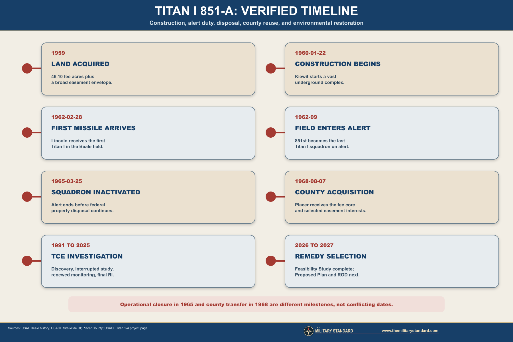
The Lincoln complex is especially well documented because it became a county property and later a major federal environmental-restoration project. Official records identify a roughly 46-acre fee parcel surrounded by a much larger envelope of safety, access, and other easements. They also preserve unusual construction detail, including hard granite, shallow groundwater, about 470,000 cubic yards of excavation, an on-site concrete batch plant, and approximately 90,000 cubic yards of concrete attributed to this facility. Those figures describe a civil-engineering undertaking as much as a weapons installation.
The operational era was brief. The first missile reached the Lincoln complex on February 28, 1962, the Beale field achieved alert status in September, and Titan I phaseout began little more than two years later. The first Beale Titan left alert on January 4, 1965, and the 851st was inactivated on March 25. By June 1965 the federal government was transferring the fee land and easement interests into the disposal process, and by 1968 Placer County had acquired the core property.
Postmilitary reuse produced a second, complicated history. County functions included a corporation yard, California forestry and fire facilities, road-maintenance activity, and pistol and trap or skeet ranges. Trichloroethene, usually abbreviated TCE, was identified in groundwater during environmental investigation, while lead contamination came from the later county ranges. The U.S. Army Corps of Engineers is responsible for the FUDS groundwater and soil-vapor response; Placer County is separately responsible for the gun-range lead cleanup. Keeping those two programs distinct is essential to an accurate present-day account.
Installation Identity and Permanent Record
The permanent project identity is Titan I Missile Complex 851-A, installation_uid MBH-USAF-CA-0054, and site_uid MBH-SITE-CA-0313. The parent installation is Camp Beale / Beale Air Force Base, installation_uid MBH-USAF-CA-0021. Although the missile crews, security structure, maintenance system, and higher command led back to Beale, the Lincoln property was a geographically separate operating installation with its own acquisition, construction, disposal, environmental, and local-government history.Several official names refer to this same place. Air Force historical writing uses 851-A and Complex 4A, while Corps documents use Former Beale AFB Titan 1-A Missile Facility, Beale AFB Facility S-1, property number J09CA1108, property identifier CA99799F599600, and HTRW project J09CA1108-01. County records often shorten the name to the former Titan 1-A missile site or Lincoln former missile facility.
The letter and number systems can be confusing. The squadron designation was 851st, the field's western site was A, and contemporary Air Force narrative calls it Complex 4A. Modern FUDS usage says Titan 1-A, in which the numeral identifies the missile system and the letter identifies the Lincoln complex. This history preserves the established public-page name 851-A while listing all authoritative aliases so that records can be matched without inventing a new identity.
Location, Coordinates, and Boundary Limits
Official environmental documents place the facility about 1.6 miles east of Lincoln and about 20 miles northeast of Sacramento. Historical records use 401 Oak Tree Lane, while the county gun-range remedial plan uses 351 Oak Tree Lane. Those addresses arise from different property, access, and program records within the former federal holding.The official disposal schedule separates fee ownership from easements. The United States reported 46.10 fee acres and 227.59 easement acres sent to the General Services Administration on June 22, 1965, while another 1.30 acres of easements were terminated. The combined fee and transferred-easement figure is 273.69 acres, close to the approximately 275 acres often used in Corps summaries. It would be misleading to enter 275 acres as if the government owned every acre in fee or as if the missile plant physically occupied that entire envelope.
The approximately 46-acre core also should not be confused with the underground footprint. The three launcher areas, control center, power house, antenna silos, terminals, tunnels, access portal, and surface support occupied only portions of the fee property. The easement belt served isolation, safety, access, utilities, and restrictions beyond the structural core. Later county parcel divisions created park, mixed-use, and corporation-yard parcels without changing the historical fact that the original military interests were broader and legally varied.
Why Beale Received Titan I
Titan I entered deployment while Strategic Air Command was moving from a bomber-centered retaliatory force toward a mixed force of bombers and intercontinental missiles. The missile offered long range and a powerful nuclear payload, but its cryogenic liquid-oxygen system, radio-inertial guidance, above-ground launch requirement, and large underground support plant made each operational site complex and labor intensive. The Air Force placed early Titan squadrons at widely separated western and central bases to complicate enemy targeting and to build a survivable first-generation missile force as quickly as technology allowed.Beale offered strategic and geographic advantages. Its inland California location supported dispersed sites away from the coast, while the Sacramento Valley provided access to transportation, construction labor, utilities, and a major Air Force support base. The three complexes were separated from Beale and from one another, reducing the chance that one attack or one accident would disable the entire field. Beale supplied the institutional center for personnel, training, logistics, nuclear support, administration, maintenance, and communications while the remote complexes performed the alert mission.
The missile assignment also fit Beale's transformation. The former wartime Army installation was becoming a Strategic Air Command base with expanding bombardment, tanker, missile, and later reconnaissance responsibilities. Official Beale history places the Titan support era between 1959 and 1965. The 851st was assigned first under the 4126th Strategic Wing, which SAC had activated at Beale, and then under the 456th Strategic Aerospace Wing after the 4126th was redesignated on February 1, 1963.
Site Selection and Land Acquisition
The government acquired the Lincoln property from Floyd R. Bonnifield and other interests in 1959. Site selection had to satisfy far more than a distance circle around Beale. Engineers needed a defensible location with sufficient land for safety restrictions, suitable approaches for heavy construction, access to electrical and communications systems, workable geology, and separation from population centers as they existed at the end of the 1950s. The later expansion of Lincoln and nearby residential development should not be projected backward onto that initial rural setting.The fee-and-easement pattern shows how Titan deployment shaped land control. The Air Force needed direct ownership of the structural core but could protect the complex through easements across a much larger surrounding area. These interests could limit incompatible development, provide access, or support utilities without requiring federal purchase of every surrounding parcel. The pattern also explains why disposal took several transactions: fee land could be conveyed to a public agency, some easements could revert to prior owners, and restrictive interests could remain or be assumed separately.
Site choice proved technically demanding. Corps accounts describe hard, shallow granite and groundwater encountered only 20 to 30 feet below ground. Those conditions increased drilling, blasting, pumping, and mud-control work. The Lincoln site was therefore not merely a standard plan placed into an empty field. Local geology dictated the actual pace, methods, temporary works, and risk of construction, and it helps explain the extraordinary excavation and concrete quantities recorded in the site history.
Contract and Construction Management
Peter Kiewit Sons Company began construction on January 22, 1960, under the U.S. Army Corps of Engineers Beale Area Office. The Beale Titan undertaking was described as the largest Corps project in California at that time. As the national missile program expanded, the Corps created the Corps of Engineers Ballistic Missile Construction Office, known as CEBMCO, on August 1, 1960. Oversight of the Beale work shifted to that specialized organization on November 1, carrying 95 Construction Branch personnel into the new arrangement.The management change reflected the exceptional demands of first-generation ICBM construction. A Titan complex combined heavy underground civil works with precision missile equipment, cryogenic propellant systems, high-capacity electrical generation, protected communications, and exacting installation tolerances. The builder could not treat the site as a conventional industrial project, because structural completion had to connect with weapons-system installation, acceptance testing, crew training, and Strategic Air Command operational certification. Schedule pressure was intense while design changes and field discoveries continued.
Parish Brothers of Benicia performed excavation work, and open-cut excavation was reported complete on June 27, 1960. Silo shafting had begun on March 10.
Excavation, Granite, and Groundwater
Approximately 470,000 cubic yards of material were removed at Lincoln. The excavation exposed granite close to the surface, requiring drilling and blasting rather than simple earthmoving. Groundwater at 20 to 30 feet created muddy working conditions long before crews reached the approximately 160-foot launcher depth. Construction therefore required continuous management of slopes, access ramps, haul routes, pumps, temporary drainage, and blast sequencing while crews shaped multiple deep structures connected by underground passages.Backfilling began in September 1960 as major concrete structures rose within the excavations. The sequence was deliberate: builders excavated a huge open complex, constructed reinforced cylinders and rooms, installed or protected embedded systems, and then returned material around the hardened plant. The completed installation concealed much of the work below a comparatively sparse surface. That contrast between modest surface appearance and massive underground volume is one of the defining characteristics of Titan I sites.
The groundwater encountered during construction foreshadowed later environmental and structural concerns, but it should not be equated automatically with contamination. Natural groundwater entered the deep excavations because the facility extended far below the water table. Decades later, environmental investigations addressed TCE in groundwater and soil vapor, while the submerged or flooded underground plant presented separate access and engineering hazards. The existence of water in the silos does not by itself identify the source or concentration of a chemical release.
Concrete, Forms, and Site Production

The Lincoln work used a portable Noble concrete batch plant rated at roughly 80 cubic yards per hour. Aggregates came from the Richter and Harm Bear River plant near Sheridan. Slip-form operations extended from August 26 through October 29, 1960, allowing crews to construct tall cylindrical reinforced-concrete features with continuously moving forms. The specialized forms fabricated for Lincoln were then used at the Beale field's B and C complexes, giving 851-A an important role in the construction sequence beyond its own boundary.
The form reuse also helps explain why field construction was a networked program. Lessons, tooling, crews, and production methods moved from one complex to the next. A problem solved at Lincoln could benefit Sutter Buttes and Chico, while design changes at a later site could affect acceptance or retrofit work across the field. The three installations shared a weapons mission, but the sequence of construction created practical dependencies among them before any missile went on alert.
Standard Titan I Physical Plant
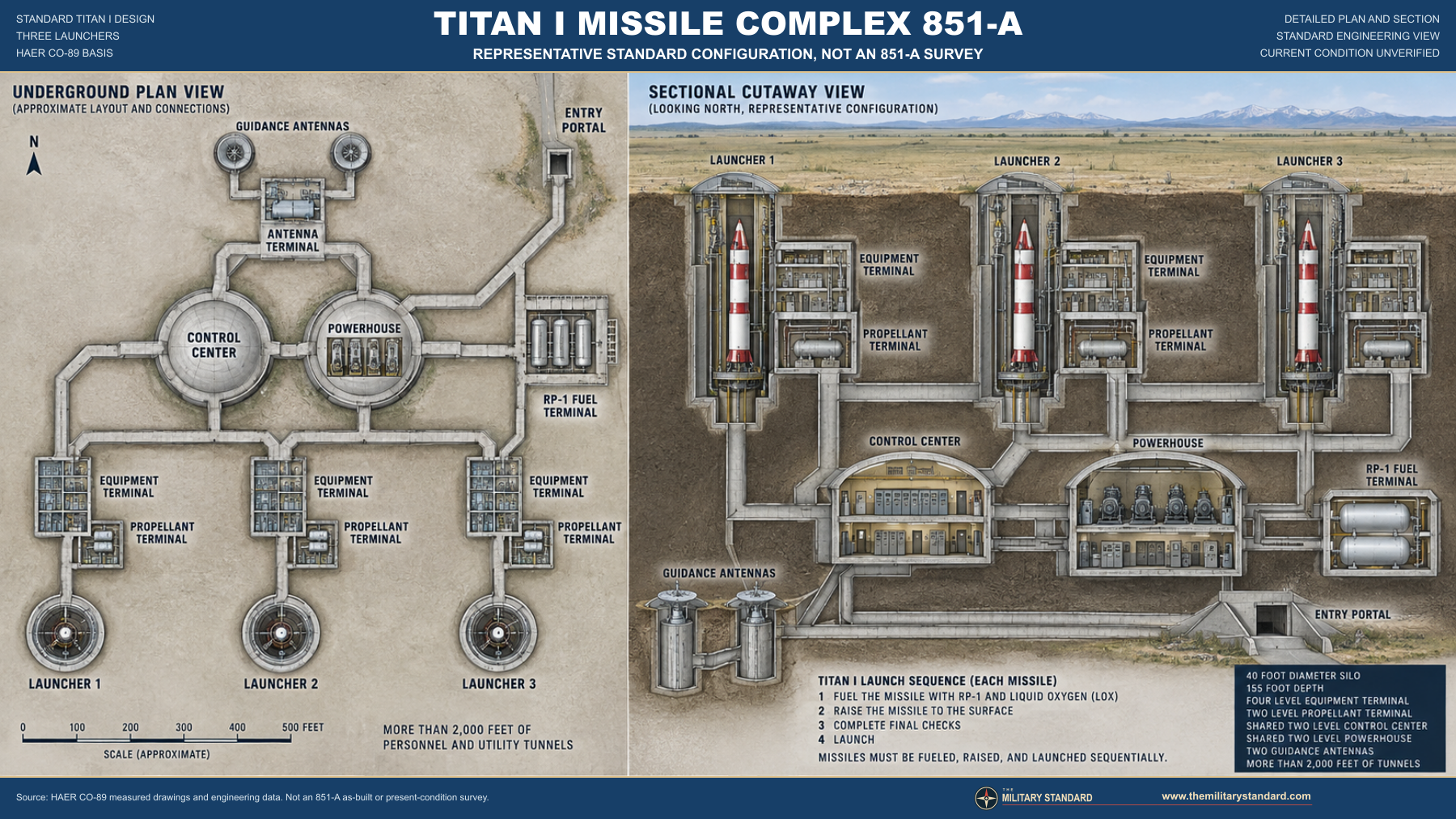
Each launcher branch functioned as part of one integrated plant rather than as an independent hole in the ground. Electrical power, communications, environmental control, propellant service, guidance data, and command authority had to reach the launcher through protected spaces. The control center supported combat-crew operations and authentication. The power house maintained electrical continuity. Antenna equipment connected the site to the external guidance and command network, while the terminals managed the hazardous fluids required to ready a missile for launch.
The surface plan was intentionally understated. Roads, vents, portals, covers, support buildings, fencing, security zones, and utility features marked the site, but most operational volume lay below ground. The silos protected missiles during alert storage; they were not launch tubes in the later Minuteman sense. Before launch, Titan I had to be fueled, raised to the surface by elevator, and launched from the exposed position. That sequence imposed time, machinery, and vulnerability penalties that later solid-fueled missiles avoided.
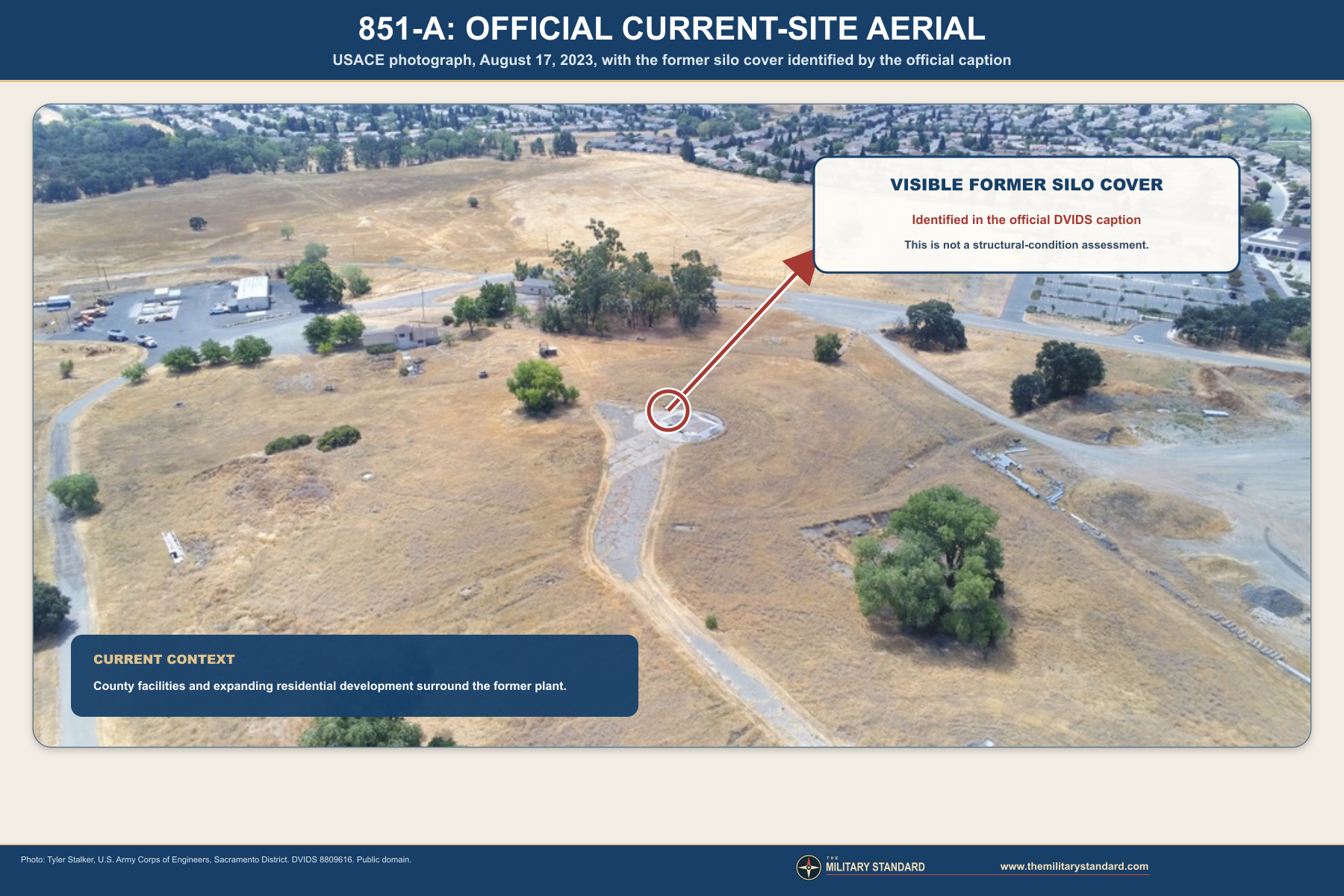
The standard-layout graphic accompanying this history is therefore labeled as a verified standard engineering interpretation, not a surveyed Lincoln as-built plan. It shows functional relationships supported by Titan I engineering documentation without pretending to reproduce every local road, grade, fence, or postmilitary alteration. The current aerial photograph is kept separate so viewers can distinguish the Cold War system diagram from what remains visible today.
Missile System and Launch Method
The HGM-25A Titan I was the United States' first operational multistage intercontinental ballistic missile. It used kerosene-type fuel and liquid oxygen, with liquid oxygen loaded during launch preparation because it could not be stored indefinitely in the missile. Radio-inertial guidance relied on a ground-based system that tracked and updated the missile during the early flight. These characteristics made the weapon a major advance over earlier single-stage designs while also creating a large support burden at each complex.An alert sequence required verified command messages, crew coordination, system checkout, propellant operations, guidance readiness, opening the silo cover, raising the fueled missile, and completing launch from the surface. The crew did not simply press a button beside a permanently fueled missile. Multiple mechanical, electrical, communications, and procedural systems had to work in order. The elaborate complex was a physical expression of that chain, and the short service life reflected how rapidly the Air Force improved beyond it.
The Titan I carried a nuclear reentry vehicle and served a deterrent mission rather than a routine firing program. No missile was launched from the Lincoln facility. Operational success was measured by secure alert time, readiness inspections, crew proficiency, maintenance, and the ability to execute a valid order if national command authority required it. The absence of a launch is not evidence that the installation was inactive; continuous alert without use was the purpose of the deterrent.
The 851st Strategic Missile Squadron
Official lineage and public-history sources describe the squadron's beginning with slightly different administrative dates. Air Force lineage records activate the 851st Strategic Missile Squadron on August 25, 1960, and organize it on February 1, 1961, while Beale public history says the squadron was activated April 1, 1961. These dates can represent separate establishment, activation, organization, and effective-operating milestones. The history retains the distinctions rather than selecting one date and making the other sources appear wrong.The squadron's mission required much more than launch crews. Missile maintenance specialists, facilities personnel, communications technicians, security forces, supply functions, trainers, evaluators, and headquarters staff linked the remote sites to Beale. Each complex had to sustain crews underground, maintain the missile and its support equipment, control access, and communicate through protected channels. Beale handled many functions that did not need to be duplicated at every launcher location, while the sites maintained the equipment and personnel that had to remain close to the weapons.
The squadron belonged to Strategic Air Command's larger missile structure. It was assigned to the 4126th Strategic Wing from organization in 1961 until February 1, 1963, when the 456th Strategic Aerospace Wing replaced the 4126th and assumed its mission, personnel, and equipment. That relationship placed the dispersed field inside a base organization already responsible for strategic missions. The installation history therefore cannot be understood by looking only at the 46-acre Lincoln parcel; it was one node in a wider chain of command, logistics, nuclear custody, training, and communications.
First Missile at Lincoln
The first missile moved to Complex 4A at Lincoln on February 28, 1962. That date is the strongest site-specific operational milestone and demonstrates that Lincoln led the field's missile emplacement sequence. The last of the Beale field missiles was lowered at Chico on April 20, 1962. Movement into a launcher did not by itself equal full operational alert, because checkout, acceptance, crew certification, guidance integration, and command-system readiness still had to follow.The Lincoln emplacement also marked a transition from construction project to weapons installation. Responsibility shifted gradually among contractors, Corps engineers, Air Force acceptance teams, maintenance personnel, and operational crews. Deficiencies could require correction after structural work appeared complete. The site's readiness depended on both the physical plant and the Titan weapon system, so published dates for completion, turnover, control, and alert describe different phases rather than interchangeable versions of a single opening day.
Turnover, Alert, and Operational Readiness
The 851st entered field alert in September 1962 and was the last Titan I squadron to do so. A secondary chronology gives September 8 as the date nine Beale launchers were turned over to Strategic Air Command and declared operational, but the reviewed official Air Force accounts support only the month at that precision.Two months after the entire squadron became fully operational, it became the first Titan I unit to pass an Operational Readiness Inspection. That achievement reflected crew performance, maintenance, security, communications, technical orders, and the reliability of the full support system. It did not erase the difficulties of first-generation missile technology, but it shows that the Beale field developed into a credible operational force after the compressed construction and activation period.
The timing placed the new field inside one of the most dangerous periods of the Cold War. The Cuban Missile Crisis unfolded in October 1962, shortly after the squadron reached alert. The Lincoln complex was therefore not a completed facility waiting for some future mission; it was part of the national strategic force during an immediate confrontation. Exact crew actions at 851-A during the crisis were not located.
Relationship to 851-B and 851-C
The three Beale complexes were operational siblings, but their histories diverged. Lincoln received the field's first missile. The Sutter Buttes or Live Oak complex formed the central geographic member. Chico received the last missile and suffered a destructive accident on May 24, 1962, when a blocked vent and blocked valve contributed to an explosion that destroyed a missile and damaged the silo. Repairs returned Chico to operational status on March 9, 1963.The Chico accident mattered to Lincoln even though it occurred at another complex. A serious event at one site affected the squadron's total launcher count, technical procedures, safety awareness, investigation workload, and public understanding of the field. It also illustrates the reason for geographic dispersal: damage at one complex did not physically destroy all nine launchers. At the same time, common equipment and procedures meant that findings could have implications beyond the damaged site.
Construction tied the field together in a different way. Forms produced at Lincoln were reused at the other complexes, and program management applied across all three. Beale public affairs later summarized the total cost of the three sites as more than $40 million. Because the sites shared contracts, support systems, and standardized engineering, some surviving totals are field-wide rather than cleanly divisible among A, B, and C. Site-specific and program-level figures are labeled accordingly throughout this history.
Role in the Wider Military Network
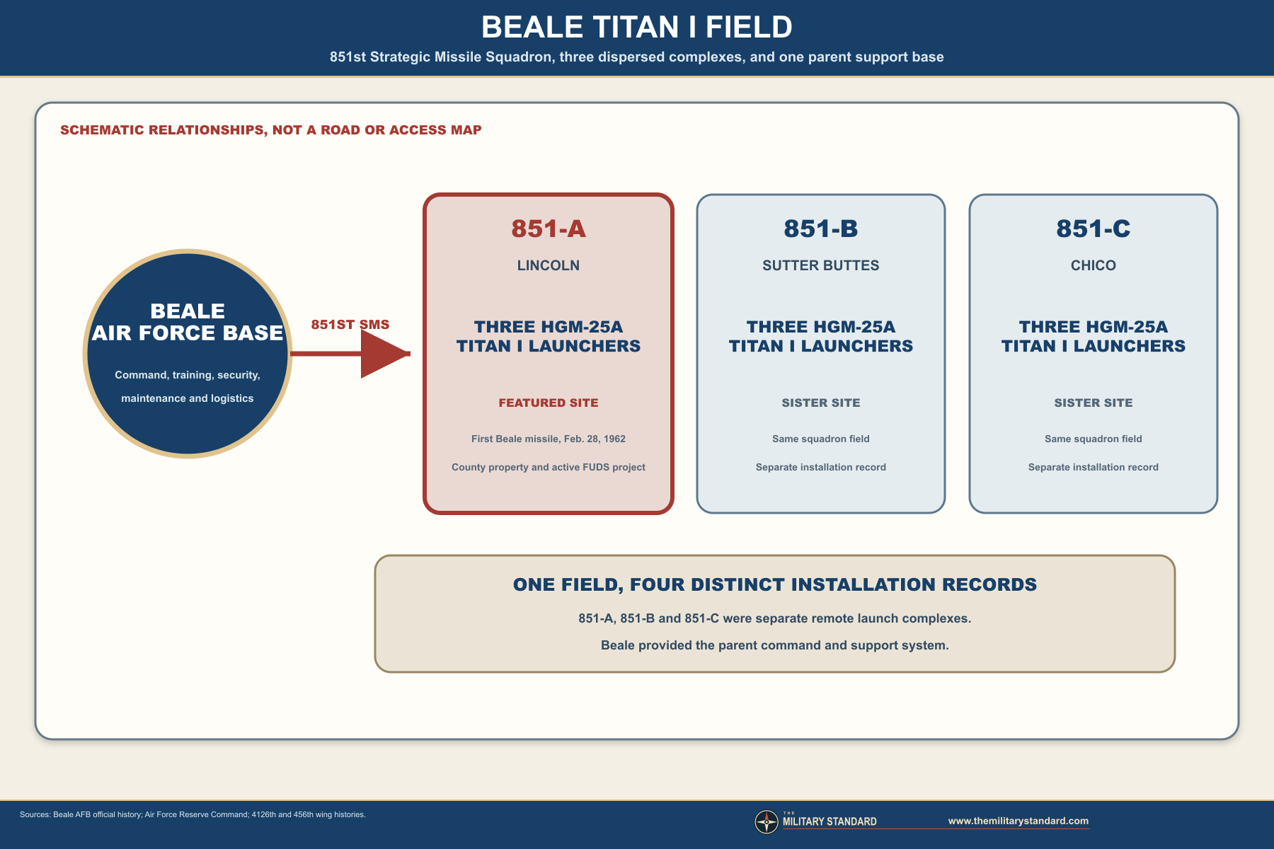
The complex also depended on civilian infrastructure and regional geography. Roads carried oversized construction loads and later missile and support equipment. Commercial suppliers furnished aggregate, concrete inputs, cable, piping, and thousands of components. Local property interests carried easements and restrictions. After closure, the same site entered county road, fire, recreation, and land-planning systems, showing how a secretive strategic facility could become deeply entangled with ordinary regional government.
Phaseout and Deactivation
On May 16, 1964, Secretary of Defense Robert McNamara directed accelerated phaseout of Titan I. The decision reflected the arrival of solid-fueled Minuteman and more capable Titan II systems, which reduced reaction time, simplified alert operations, and improved survivability. Titan I was not removed because Lincoln had failed. It was retired because the strategic-missile technology and force structure had advanced beyond a first-generation system that required fueling and elevation before launch.The first Beale Titan was removed from alert on January 4, 1965. Public sources do not identify that missile conclusively as a particular Lincoln launcher, so this history treats January 4 as a field milestone rather than claiming an unsupported silo-level event. The 851st Strategic Missile Squadron was inactivated March 25, 1965. Those dates distinguish alert termination from unit inactivation, and neither should be confused with later property disposal or the date on which every missile component had physically left the complex.
The missiles were removed by March 1965, dismantled, and shipped to the San Bernardino Air Materiel Area at Norton Air Force Base. Salvage and system removal stripped the facility of military equipment with reuse or material value. Later launcher-disablement actions are sometimes described in relation to Strategic Arms Limitation requirements, but SALT I came years after the immediate 1965 retirement. The original phaseout resulted from weapons modernization; later treaty-verification or disablement practices belong to a separate chronology.
Federal Disposal and 1968 County Transfer
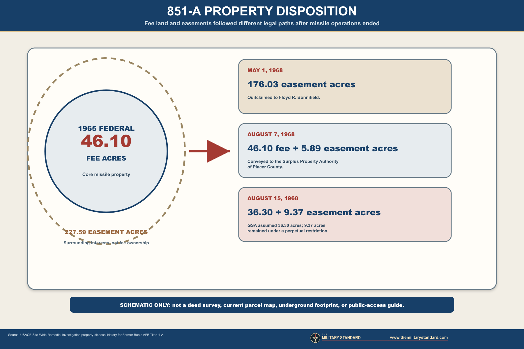
On August 15, 1968, GSA assumed 36.30 acres of easements, while 9.37 acres remained under a perpetual restrictive easement according to the property account. The reviewed sources do not provide a modern title opinion tracing every one of those interests to the present. They do establish that federal disposal was a staged legal process and that Placer County became owner of the core former missile property in 1968.
The disposal chronology also resolves an apparent date conflict in municipal summaries that call the site decommissioned in 1968. Military alert and squadron operations ended in 1965; federal property disposition and county acquisition continued through 1968. Both dates are meaningful, but they answer different questions.
County Reuse and Changing Land Context
Placer County adapted the property to several public uses. Official environmental records identify a California Division of Forestry fire station or trailer, a road-maintenance equipment yard and shop, fuel-storage and wash areas, a trap and skeet club, and a pistol range with a large earthen berm. County records confirm continued corporation-yard use on part of the property. These uses occupied or overlaid the former missile parcel without turning the underground plant into a public museum or routine-access facility.The county closed the gun ranges in 1999. By 2016 it described the property as a 46-acre site and continued to use part as a corporation yard. A recorded parcel map divided the property into park, mixed-use, and corporation-yard parcels while preserving the exterior boundary. Later agreements conveyed road right-of-way and related easements to the City of Lincoln for new roads, utilities, and landscaping connected with Village 1 development around the site.
Lincoln's growth transformed the setting. Land that had been selected for rural isolation now lies next to expanding residential development, including Sun City Lincoln Hills. This change did not move the historical installation, but it increased the importance of precise environmental communication, wildfire and field-work controls, property planning, and public participation. It also means that historic photographs showing open countryside cannot be used as a current land-use map.
TCE Discovery and Early Investigation
Environmental investigation found TCE in groundwater in 1991. TCE is a chlorinated solvent historically used for cleaning and degreasing, and Corps documents associate the restoration project with contamination from former military operations. Early reported groundwater detections ranged from 86 to 490 micrograms per liter, well above the federal drinking-water maximum contaminant level of 5 micrograms per liter. Those historical values describe particular samples and dates, not a uniform concentration across the entire property or community.Investigators sampled flooded underground structures in 1993 and conducted additional work in the mid-1990s. A later pilot treatment in the 2000s removed about ten pounds of TCE. Field work stopped in 2009 for more than a decade while the government examined causation and eligibility under the FUDS program, then investigative work resumed in 2018 with additional monitoring wells and soil-vapor probes. This interrupted chronology helps explain why a contamination first identified decades ago remained in the investigation and remedy-selection process in 2026.
TCE occurrence and the deep underground plant are related but not identical subjects. Water in a silo may provide a sampling medium or pathway, while contamination in groundwater and soil gas is evaluated through monitoring networks, geology, concentration trends, exposure assumptions, and regulatory standards. A photograph of a flooded opening cannot define the plume. Conversely, an environmental program status does not certify the stability of old underground structures.
The Fuds Remedial Investigation
The U.S. Army Corps of Engineers leads the federal response through the Formerly Used Defense Sites program, with the California Central Valley Regional Water Quality Control Board serving as lead regulator. The property identifier is CA99799F599600, the property number is J09CA1108, and the hazardous, toxic, and radioactive waste project is J09CA1108-01. The site is not on the National Priorities List. Those identifiers should remain attached to the record because they distinguish the Lincoln project from the two other Beale Titan complexes.The modern monitoring network included 33 groundwater wells and 24 soil-vapor probes. Additional wells and probes were installed to improve definition of the western or northern edges and to investigate soil-vapor findings. The final Remedial Investigation, released in February 2025, concluded that the extent of contamination above drinking-water standards was largely understood and that groundwater and soil vapor could create unacceptable future risk if left unaddressed. That future-risk conclusion is compatible with the current statement that nearby residents face no imminent risk.
USACE says groundwater at the project location is not used as a drinking-water source. It also reports that current monitoring data do not indicate an imminent risk to neighboring communities. Those statements do not mean that no cleanup is necessary, because remedy selection considers future land and water use, vapor pathways, plume behavior, and long-term protectiveness. Accurate public history must preserve both parts: no imminent current community risk and a documented contaminant problem requiring continued federal action.
Feasibility Study and 2026 Status
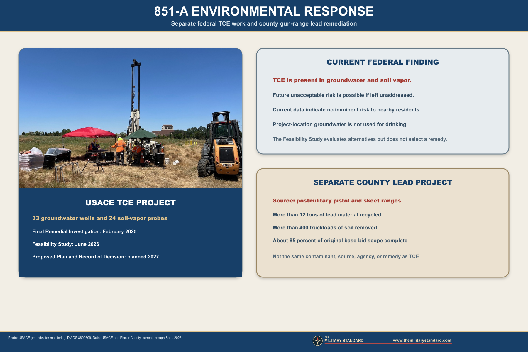
The Corps schedules a Proposed Plan and Record of Decision for 2027. The Proposed Plan will identify a preferred alternative and open a public-comment period. The Record of Decision will document the selected remedy and respond to comments, after which remedial design and remedial action can proceed. These are planned dates, not completed milestones, and they should not be rewritten as guarantees that cleanup construction will start or finish in a particular year.
Treatability work evaluates whether in-situ chemical oxidation and enhanced bioremediation can reduce contamination under actual site conditions. Monitoring rounds were scheduled for the weeks of May 11 and September 7, 2026, with a draft treatability report due to the regulator in March 2027. Separate semiannual groundwater monitoring was being contracted for late 2026. These activities show that remedy development remained technically active after completion of the main investigation and feasibility reports.
Restoration Advisory Board and Community Role
USACE approved a Restoration Advisory Board in 2023 and began meetings in 2024. The board provides a structured forum for community members, regulators, local governments, and the federal project team to exchange information and raise concerns. It does not select the legal remedy or replace the Corps and Water Board authorities. The distinction matters because public participation influences understanding and comment while formal environmental decisions still follow the federal process.As of September 2026, the next listed meeting was October 15, 2026. The Corps selected a new community co-chair in April 2026 and continued newsletters, presentations, meeting records, and technical updates. Public concern has focused on plume direction, nearby development, health, property values, monitoring coverage, project pace, and site hazards. The record benefits from this engagement because it produces dated explanations that can be checked against technical reports rather than leaving the history dependent on rumor.
Separate County Gun-Range Lead Cleanup
Lead contamination at the former pistol and skeet ranges resulted from postmilitary county use, not from the Titan missile system. Placer County is managing that project separately from the Corps TCE response. The county's remedial plan identifies the range property at 351 Oak Tree Lane within the roughly 46 fenced acres, documents the former firing lines and berms, and targets residential cleanup standards. The different responsible agencies, contaminants, sources, and remedies must not be merged into one generic missile-site cleanup.By July 2026, county work had recovered and recycled more than 12 tons of lead material, sent more than 400 truckloads of soil to hazardous-waste facilities, and completed about 85 percent of the original base-bid scope, including full removal of the pistol-range berm. The Board of Supervisors approved an updated contract that brought the project total to about $8.6 million. Work was scheduled to continue during summer and early fall.
County material says the property could eventually support a park or another use, but such possibilities are not a completed reuse decision. Environmental cleanup, land planning, road construction, and the continuing corporation yard affect what can happen next. This history therefore records the verified present use and active cleanup while labeling possible future park use as planning context rather than a current status.
Surviving Features, Safety, and Access
Deep flooded structures, confined spaces, deteriorated concrete and steel, buried voids, environmental monitoring equipment, excavation areas, and work traffic can create serious hazards. County ownership and public-agency activity do not make the former launch plant an open park. Coordinates and historical diagrams are supplied for identification and interpretation only. They are not instructions for entering the property, locating openings, or bypassing controls.
The available public record does not provide a current professional structural survey of every underground component. Statements such as intact, demolished, or filled can therefore be misleading unless attached to a particular feature and date. The defensible conclusion is that major Titan I structures remain as subsurface or surface remnants, the exact condition varies and is not fully documented publicly, and both environmental and redevelopment work continue to change parts of the site.
Present Status
Titan I Missile Complex 851-A is a decommissioned strategic-missile installation owned by Placer County. Part of the approximately 46-acre core continues in corporation-yard use, while former range areas and other portions are involved in cleanup and land-planning activity. The federal FUDS response addresses TCE in groundwater and soil vapor. The county project addresses lead associated with the former gun ranges. Neither project should be presented as complete as of September 2026.The final Remedial Investigation and Feasibility Study are complete, but remedy selection is not. USACE schedules the Proposed Plan and Record of Decision for 2027 and continues treatability and groundwater-monitoring work. Current data indicate no imminent risk to nearby residents, and project-location groundwater is not used for drinking. Those reassuring current findings coexist with the need to address potential future groundwater and vapor risks.
The property is also part of a rapidly changing urban edge. New roads, easements, nearby subdivisions, and possible future park or mixed-use decisions place the former military site within Lincoln's long-range development context. Its historical importance, environmental obligations, county operations, and physical hazards all remain relevant to any future reuse.
Chronology
- 1959 The United States acquires the Lincoln complex property from Floyd R. Bonnifield and other interests. The military holding includes a 46.10-acre fee core and a much larger easement envelope.
- 1960-01-22 Peter Kiewit Sons Company begins construction under the U.S. Army Corps of Engineers Beale Area Office.
- 1960-03-10 Silo shafting begins at the Lincoln complex.
- 1960-06-27 Open-cut excavation is reported complete after removal of approximately 470,000 cubic yards of material.
- 1960-08-01 The Corps of Engineers Ballistic Missile Construction Office is established to manage the expanding ballistic-missile program.
- 1960-08-26 to 1960-10-29 Slip-form concrete operations build major cylindrical structures. Forms fabricated for Lincoln are later reused at the B and C complexes.
- 1960-09 Backfilling begins around completed or advancing underground structures.
- 1960-11-01 Management of the Beale Titan project transfers to the specialized ballistic-missile construction organization, including 95 Construction Branch personnel.
- 1960-08-25 Air Force lineage records activate the 851st Strategic Missile Squadron.
- 1961-02-01 Air Force lineage records organize the 851st Strategic Missile Squadron. A Beale public-history source separately uses April 1, 1961 as its activation date.
- 1962-02-28 The first Titan I missile in the Beale field is moved to Complex 4A at Lincoln.
- 1962-04-20 The last missile in the three-complex field is placed at Chico.
- 1962-05-24 An explosion at sister complex 851-C destroys a Titan I and damages a Chico silo. The event does not physically damage Lincoln but affects the squadron's field readiness and technical program.
- 1962-09 The 851st Strategic Missile Squadron enters alert, the last Titan I squadron to achieve that status. A secondary chronology gives September 8, but reviewed official sources support the month rather than that exact day.
- Late 1962 Two months after full operational status, the 851st becomes the first Titan I unit to pass an Operational Readiness Inspection.
- 1963-03-09 The repaired Chico complex returns to operational status, restoring the damaged sister site to the field.
- 1964-05-16 Secretary of Defense Robert McNamara directs accelerated phaseout of Titan I.
- 1965-01-04 The first Beale Titan I is removed from alert. The reviewed public record does not identify the particular launcher.
- 1965-03 Titan missiles are removed and sent through the San Bernardino Air Materiel Area at Norton Air Force Base for dismantling and disposition.
- 1965-03-25 The 851st Strategic Missile Squadron is inactivated.
- 1965-06-22 The United States reports 46.10 fee acres and 227.59 easement acres to GSA and terminates another 1.30 acres of easements.
- 1968-05-01 GSA quitclaims 176.03 acres of easements to Floyd R. Bonnifield.
- 1968-08-07 GSA conveys 46.10 fee acres and 5.89 easement acres to the Surplus Property Authority of Placer County.
- 1968-08-15 GSA assumes 36.30 acres of easements; 9.37 acres remain under a perpetual restrictive easement in the property account.
- After 1968 Placer County develops public uses including a corporation yard, fire or forestry facilities, road-maintenance functions, and pistol and trap or skeet ranges.
- 1991 Environmental investigation identifies TCE in groundwater, beginning the documented modern restoration chronology.
- 1993 Investigators sample water associated with flooded underground structures.
- 1999 The county gun ranges close, leaving lead-impacted soil and range features for later remediation.
- 2000s A pilot environmental treatment removes approximately ten pounds of TCE.
- 2009 Field investigation pauses while federal agencies examine causation and FUDS eligibility questions.
- 2016 Placer County records a parcel map dividing the former property internally while retaining corporation-yard use and the exterior property boundary.
- 2018 Environmental field work resumes with monitoring wells and soil-vapor probes.
- 2021 County and city records address road right-of-way and infrastructure easements around the former site within the Village 1 development area.
- 2022 The county gun-range Remedial Action Plan documents the 351 Oak Tree Lane range area, postmilitary lead source, corporation yard, and growing residential surroundings.
- 2023 USACE approves a Restoration Advisory Board for the Titan 1-A environmental-restoration project.
- 2024-03-26 The first Restoration Advisory Board meeting is held.
- 2024-05 USACE installs additional monitoring wells, including MW-61 through MW-64. A proposed MW-65 is not installed according to the 2025 public-question record.
- 2025-02 USACE completes the Final Remedial Investigation and treatability-study work plan.
- 2025 The monitoring network includes 33 groundwater wells and 24 soil-vapor probes. Investigation and semiannual monitoring continue.
- 2026-04 A new community co-chair is selected for the Restoration Advisory Board.
- 2026-06-26 USACE announces completion of the Feasibility Study, which evaluates alternatives but does not select a remedy.
- 2026-07 Placer County approves continued gun-range lead remediation. More than 12 tons of lead have been recycled, more than 400 truckloads removed, and the original base-bid scope is about 85 percent complete.
- 2026-09 USACE continues treatability and monitoring work. Current data indicate no imminent risk to nearby communities, and project-location groundwater is not used as drinking water.
- 2026-10-15 USACE lists Restoration Advisory Board Meeting 8 for this date. It is a scheduled future event as of the research cutoff, not a completed milestone.
- 2027 planned USACE schedules publication of a Proposed Plan and Record of Decision, followed by remedial design and action after remedy selection.


Sources & References
- WEB Cold War Relics: Deactivated Titan 1 Missile Silos Surround Beale SOURCE FOR: Official Air Force field identity, construction start, equipment quantities, first and last missile emplacement, Chico accident, September 1962 alert, readiness inspection, phaseout, and 2013 ownership summary.
- WEB Titan 1 Missile Facility Provides Glimpse into Beale's Past SOURCE FOR: Official Air Force Reserve account of the 851st, the Lincoln, Live Oak, and Chico complex network, and the supported relationship to Beale.
- WEB Beale's History: Past to Present SOURCE FOR: Official Beale history and the base's 1959 to 1965 support of Titan I sites near Lincoln, Chico, and the Sutter Buttes.
- WEB Cold War Relics: Beale's Bombing History SOURCE FOR: Official Beale account of the 4126th Strategic Wing, the base's Strategic Air Command activation, and the later 456th wing redesignation context.
- PDF To Defend and Deter: The Legacy of the United States Cold War Missile Program SOURCE FOR: National Titan I program, standard engineering, Beale field, construction program, phaseout context, and Cold War missile-site interpretation.
- WEB Titan I Intercontinental Ballistic Missile SOURCE FOR: National Park Service explanation of Titan I development, liquid propellants, underground storage, surface launch, guidance, and replacement.
- WEB National Museum of the United States Air Force Titan I Fact Sheet SOURCE FOR: Official Air Force missile characteristics, two-stage design, liquid-oxygen requirements, development, and operational role.
- PDF Site-Wide Remedial Investigation Report, Former Beale AFB Titan 1-A Missile Facility SOURCE FOR: Site location, acquisition, construction management, excavation, geology, groundwater, concrete production, facility components, operating period, missile removal, property disposal, county reuse, and environmental history.
- PDF Beale AFB Titan 1-A Continuing Remedial Investigation Work Plan SOURCE FOR: 401 Oak Tree Lane reference, approximately 46-acre fee property, approximately 227-acre easement envelope, three 160-foot silos, supporting structures, no site launch, 1968 county acquisition, and postmilitary facilities.
- WEB Former Beale AFB Titan 1-A Missile Complex Project Page SOURCE FOR: Current USACE status, no-imminent-risk statement, groundwater-use statement, monitoring and treatability schedule, 2027 Proposed Plan and Record of Decision schedule, RAB meetings, and administrative-record links.
- WEB USACE Releases Final Remedial Investigation Report SOURCE FOR: Completion of the 2025 Remedial Investigation, monitoring network, contamination extent, soil-vapor and groundwater findings, and next-step context.
- WEB USACE Completes Feasibility Study for Former Titan 1-A Missile Site SOURCE FOR: June 26, 2026 Feasibility Study completion, alternatives evaluated, distinction between evaluation and remedy selection, and anticipated 2027 Proposed Plan.
- PDF Public Questions and Answers from April 24, 2025 Restoration Advisory Board Meeting SOURCE FOR: Federal funding, lead agency and regulator roles, monitoring-well status, dye-test explanation, priority process, and site-specific response limitations.
- WEB Titan 1-A Missile Site Information SOURCE FOR: City of Lincoln overview, 1991 TCE discovery, 2018 field-work resumption, local responsibility statement, and community-information context. Current schedule statements are superseded by the 2026 USACE page.
- WEB Lincoln Former Titan 1-A Missile Facility Site Minor Land Division Memorandum SOURCE FOR: Placer County's 1968 acquisition, APN 021-274-031, approximately 46-acre property, corporation-yard use, and 2016 parcel action.
- WEB Village 1 Road Right-of-Way Easements Purchase and Sale Agreement SOURCE FOR: County ownership, 46-acre scale, 2016 three-parcel division, park, mixed-use and corporation-yard parcel identities, and road and infrastructure easements.
- WEB Former Placer County Gun Ranges Draft Remedial Action Plan SOURCE FOR: 351 Oak Tree Lane reference, range location within the 46 fenced acres, corporation-yard history, postmilitary lead source, surrounding development, and remediation planning.
- WEB Lincoln Gun Range Lead Cleanup Project SOURCE FOR: Current county lead-remediation status, 12 tons of recovered lead, more than 400 truckloads, 85 percent base-scope completion, and separation from the federal TCE project.
- WEB Communication, Transparency Are Key Elements in Remediation Plan for Former Nuclear Missile Site SOURCE FOR: Official USACE public-engagement account, current community context, TCE description, monitoring program, and proximity of modern residential development.
- WEB Cold War Cleanup, Aerial View, August 17, 2023 SOURCE FOR: Official public-domain aerial image of the former Lincoln complex, visible circular silo cover, and neighboring Sun City Lincoln Hills.
- WEB Cold War Cleanup, Groundwater Monitoring, October 24, 2024 SOURCE FOR: Official public-domain photograph of groundwater sampling within the 33-well project monitoring network.