
Bethel Radio Relay Station / Bethel White Alice Communications Site, Alaska
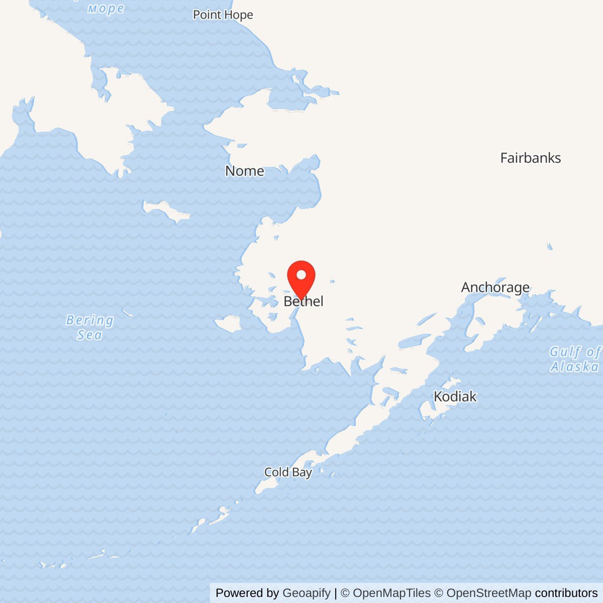
Longitude: -161.885805
Current Role: Unoccupied former relay tract owned and managed by the U.S. Air Force according to the 2022 Five-Year Review; active environmental monitoring and land-use controls, with no standing White Alice antenna.
Coordinate note: 60.778282 N, 161.885805 W is Alaska DEC's WGS84 environmental-site marker. It is not a surveyed installation center, antenna location, property boundary, or visitor access point.
Identity and setting
Bethel Radio Relay Station was a White Alice Communications System (WACS) tropospheric-scatter installation west of Bethel, Alaska. It was the junction of three long-distance radio paths, not the nearby Bethel Air Force Station radar installation, the former Bethel airport military property, or the later Bureau of Indian Affairs (BIA) headquarters property. These places were operationally and geographically related, but their facilities, land transactions and environmental cases cannot be treated as a single interchangeable site.
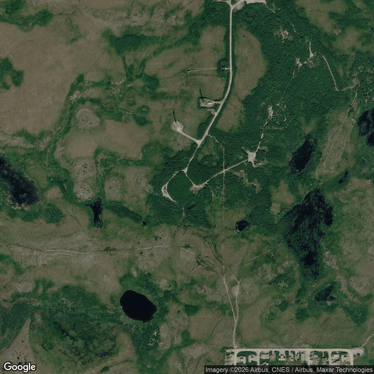
Alaska's Department of Environmental Conservation (DEC) identifies the relay station at approximately 60.778282 N, 161.885805 W, WGS84. This is DEC's representative contaminated-site point, not a surveyed installation center, an antenna location or a legal property corner. DEC describes an approximately 14-acre RRS installation surrounded by wetlands and roughly five miles west of Bethel. The Air Force's 2022 five-year review likewise places the relay buildings on a 14-acre parcel, says the site is reached by road from Bethel, and identifies it as unoccupied Air Force-owned land. The separate former BIA headquarters case covers a 27-acre administrative property with a different DEC point and environmental history.
Why the link was built
Alaska's aircraft-warning and interceptor system depended on passing radar plots, orders and voice traffic across immense distances. Ordinary line-of-sight microwave paths required many intermediate towers, while earlier radio circuits were not adequate for the dependable, high-capacity network the Air Force wanted. White Alice used powerful radio transmissions directed toward the lower atmosphere, allowing a small scattered portion of the signal to be recovered far beyond the ordinary radio horizon. The system used diversity and redundancy to keep a usable circuit when propagation changed. Bethel's position on the lower Kuskokwim made it a practical junction between western coastal warning stations and inland routes toward Alaska's command centers.
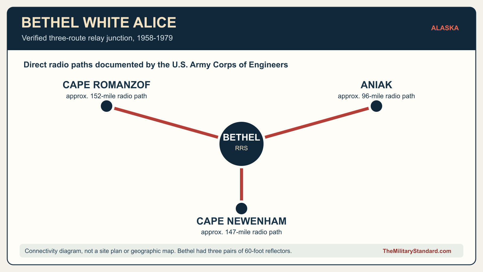
The first White Alice network contained 31 stations, some carrying tropospheric-scatter traffic and others using microwave. Bethel was one of the original troposcatter sites. Its purpose was to relay, not itself generate, the radar picture from remote warning stations. It linked Aniak to the east and Cape Romanzof and Cape Newenham toward the western and southwestern approaches. The U.S. Army Corps of Engineers' historical inventory gives approximate route lengths of 96 miles to Aniak, 152 miles to Cape Romanzof, and 147 miles to Cape Newenham. Those figures describe radio paths between stations, not road distances or a claim about the exact placement of each antenna.
Construction, facilities and operation
The Corps' White Alice inventory says Bethel's construction took place in 1957 and dates activation to 18 January 1958. An Air Force account independently confirms construction in 1957 and activation in 1958, though it does not give the day. This is a distinct event from the June 1958 start of the nearby permanent Bethel radar station. A later Corps cultural-resource survey calls 18 January the completion date, illustrating that construction-completion and activation labels can differ even when the recorded day is the same. The history therefore uses 18 January 1958 as the documented White Alice opening milestone without claiming that every circuit began full service on that exact day.
Three pairs of 60-foot billboard reflectors gave the Bethel station six large antennas, one pair oriented toward each remote partner. The historical inventory says the reflectors were deiced, an important feature where ice could change their effective shape and reduce link performance. It identifies a 6,720-square-foot equipment and power building and says the relay station had no separate dormitory because its personnel used facilities at the nearby aircraft-warning site. The Air Force's later environmental review adds an equipment/power building, facility-support and vehicle-maintenance buildings, a water tank, a pump house and fuel storage/distribution equipment to the site inventory. These descriptions come from different dates and purposes; they support the station's working infrastructure without proving that all listed structures were erected on the same day.
A 1977 Environmental Protection Agency survey chose Bethel as a representative troposcatter station and recorded six reflectors, roughly 1,000 yards of elevated conduit, two 100,000-gallon tanks, three support buildings and a small landfill containing vehicles, barrels and other debris. Its simplified 120-by-40-foot main-building measurement does not match the Corps' 6,720-square-foot equipment/power-building figure. The survey may have measured a different structure, a building before or after alteration, or used an approximation; the available evidence does not resolve this. The same caution applies to the Corps' single 6,500-barrel POL-tank description versus the EPA's two 100,000-gallon tanks. The history preserves both dated observations rather than merging them into an invented final count or capacity.
Bethel's relay function depended on more than its prominent reflectors. Equipment and power rooms converted and sustained the signals; diesel fuel and the distribution pad kept power available in a remote setting; conduit carried connections between buildings and antennas. The Corps' history of the Alaska District notes that near Bethel an aircraft-warning site, a White Alice station and an Alaska Communications System facility were designed and built during the 1955-1960 period. It describes difficult wet, ice-lensed ground. This physical setting helps explain the need for carefully engineered foundations, roads and utilities, though a Bethel-specific foundation drawing is needed before attributing any one method to a particular RRS building.
People, neighboring property and land status
The relay station was integrated with the nearby Bethel Aircraft Control and Warning station but outlived its radar mission. The state cultural-resource survey dates the radar station's closure to 15 May 1963. The BIA was permitted to use the former radar property, and the General Services Administration transferred it to BIA on 29 October 1964. White Alice continued until 1979. The Corps inventory's statement that RRS personnel used facilities at the AC&W station is strongest for the overlapping operational period; it does not establish that the former radar quarters remained in Air Force use unchanged after the BIA transfer. Later accommodation and staffing arrangements require additional unit or property records.
Public Land Order 1173 in 1955 withdrew a much larger Bethel area for Air Force use. Public Land Order 3956, published in March 1966, revoked a 1,467.31-acre portion while expressly describing the Bethel White Alice site as Air Force-reserved property beside a separate administrative tract. The land order does not make the entire withdrawn area a 14-acre relay installation. DEC's BIA case likewise distinguishes the 27-acre former administrative property from the 14-acre RRS. Some contaminated soil from the former BIA parcel was later treated at the RRS, creating an environmental connection without erasing their separate property identities.
Role in the Wider Military Network
Bethel's three directions made it a hub rather than a dead-end relay. The Aniak route connected it to further interior traffic, while the Cape Romanzof and Cape Newenham routes carried information from isolated coastal radar and warning locations. In the larger White Alice system, those paths helped move aircraft-warning information and command communications toward major Alaska Air Command nodes and North American air-defense authorities. The specific path topology matters: a failure at Bethel could have affected more than one western route, but the evidence reviewed here does not document a particular outage, alternate routing episode or measured traffic volume. The relay should not be described as a radar station simply because it carried radar-related communications.
The installation was also part of a broader Alaska communications transformation. The state historic context explains that the completed White Alice network connected the aircraft-warning and distant-warning systems with interceptor squadrons, Elmendorf and Eielson Air Force Bases, and continental defense command. The same network also supported other government and civilian communications. By the 1970s commercial leasing and new satellite-based telecommunications altered the value of fixed troposcatter routes. An Air Force account attributes Bethel's 1979 shutdown to technological obsolescence; the available sources establish the closing year but not a day-level deactivation order or the precise replacement circuit for each of Bethel's three paths.
Shutdown, demolition and preservation
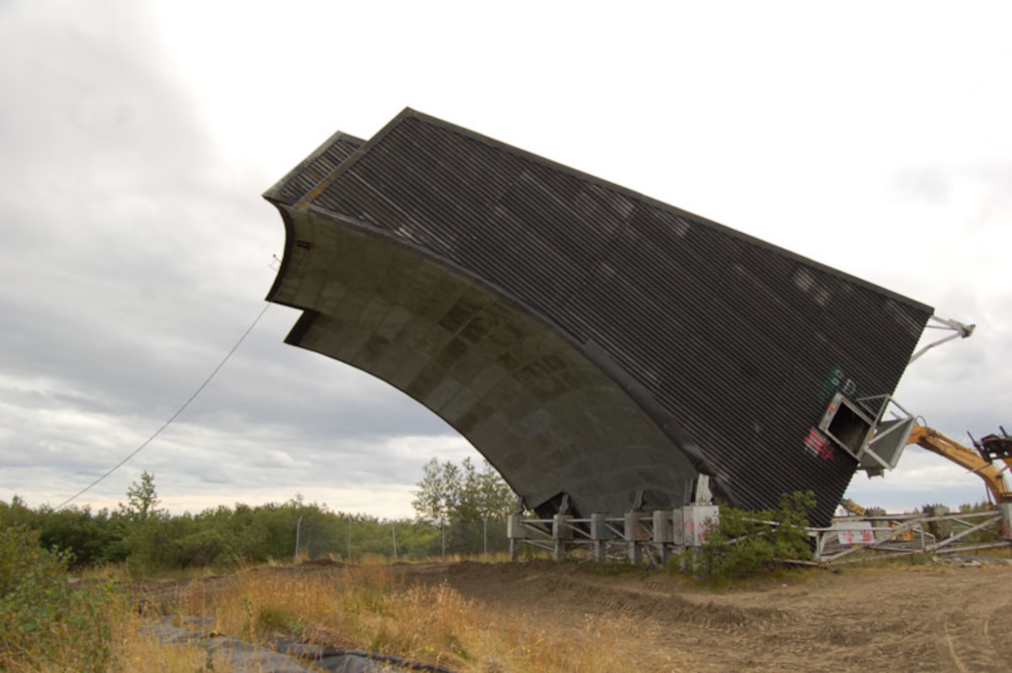
The station was deactivated in 1979, ending about 21 years of service from its 1958 opening. A Corps inventory written before final disposition considered whether some improvements might be taken over by KYUK, the regional educational broadcaster. That was a prospect, not evidence that a transfer occurred. Later Air Force and DEC records document demolition of buildings and most antennas in 1989 and 1990, with some debris buried beneath the former pad or landfill. One billboard antenna was retained at community request as a visual navigational aid, and its survival explains why photographs from different decades show different numbers of Bethel antennas.
On 26 August 2011 the 611th Civil Engineer Squadron felled the last standing Bethel White Alice antenna as part of a demolition and cleanup project. The Air Force says the 2011 work also removed about 70 cubic yards of PCB-contaminated soil for off-site disposal. DEC's later review confirms the tower and stockpile removal. The Alaska cultural-resource study marks the Bethel White Alice installation demolished. That finding is consistent with the removal of its historic radio structures, but it does not mean the land was restored to unrestricted use or that buried material vanished.

Environmental history and present condition
DEC's Bethel RRS case is active. It identifies petroleum-contaminated soil and shallow groundwater near former fuel facilities, an on-site landfill, and historic DDT and PCB concerns. A 1994 preliminary assessment recorded contaminated soil and groundwater as well as debris buried after the 1989-1990 demolition. During cleanup of the adjacent 27-acre BIA property, approximately 9,000 cubic yards of petroleum-affected soil were brought to a bioremediation cell at the RRS in the late 1990s. DEC expressly cautioned in 2003 that approval of a landfarming plan for that imported soil was not a cleanup plan for the RRS itself. Treating the BIA soil action as proof of RRS closure would invert the agency's own distinction.
After additional investigation and removal actions, the Air Force signed a Record of Decision in 2011. The remedy used a protective cap, land-use controls and monitoring rather than declaring all residual contamination removed. DEC's 2022 five-year review, approved in March 2023, found the remedy protective in the short term but identified matters affecting future protectiveness, including fence damage, cap erosion and the need for clearer recorded controls and community outreach. Its maps warn that control boundaries were preliminary and not a reliable substitute for a surveyed property polygon. DEC approved a 2025 Explanation of Significant Differences concerning the cap and fence, and it approved the final 2025 long-term monitoring report in January 2026 and the 2026 monitoring work plan in May. The case remains active; individual annual groundwater readings do not establish a simple monotonic improvement or cleanup-complete determination.
The 2022 Air Force review says the unoccupied RRS land remains Air Force owned and that neighboring land belongs to several other entities. It says the Air Force expects to retain management because the landfill prevents unrestricted use and the adjacent refuge did not accept the property on those terms. DEC notes that Bethel residents use the broader area for hunting and berry picking. The current historical resource is therefore a former communications tract with no standing White Alice antenna, continuing environmental management and land-use limits. Any visit, redevelopment claim or map should distinguish DEC's representative point and preliminary control area from surveyed ownership boundaries.
Historical significance and research limits
Bethel is unusually well documented as a three-route White Alice junction, a technological installation physically dependent on the neighboring radar complex but with a longer service life and a separate land record. Its equipment and fuel infrastructure show the scale required to keep a remote troposcatter network operating. Its 1977 waste inventory, later demolition and still-active DEC case also show why the history of a communications station does not end when the signal stops. The Air Force's 2011 photographs of the final antenna provide direct visual evidence of a Bethel structure.
Open issues remain. The original system drawings and unit records could identify exact Bethel equipment models, staffing, building alterations and any post-1963 living arrangements. Surveyed deeds or plats could settle the RRS boundary and the relationship between the 14-acre site and later environmental-control zones. Dated site photographs could show how the three antenna pairs were positioned. These gaps limit fine-grained claims but do not undermine the verified station identity, principal routes or broad chronology.
Chronology
- 1955-06-24 Public Land Order 1173 withdraws a larger Bethel area for Air Force purposes; the later relay tract is not equivalent to the whole withdrawal.
- 1957 Construction of the Bethel White Alice relay facilities and six billboard reflectors proceeds.
- 1958-01-18 Corps historical inventory records the Bethel White Alice opening milestone.
- 1958 The nearby Bethel Air Force Station radar installation begins operations; it is a separate mission and property record.
- 1963-05-15 The neighboring Bethel radar station closes while the White Alice relay continues.
- 1964-10-29 Former AC&W property is transferred to BIA; no equivalent transfer of the RRS is established.
- 1966-03-22 Public Land Order 3956 is published, releasing much of the original withdrawal while recognizing an Air Force-reserved White Alice site.
- 1977 EPA inventories Bethel as a representative operating troposcatter station, including six reflectors, fuel tanks, support buildings and a landfill.
- 1979 Bethel White Alice service ends; no exact day-level deactivation order was found for this version.
- 1989-1990 Most relay structures are demolished and debris is placed beneath the pad or landfill; one antenna remains at community request.
- 1994 Preliminary environmental assessment documents petroleum, DDT and buried-debris concerns.
- 1996-1998 Contaminated soil from the separate BIA parcel is moved into a bioremediation cell at the RRS.
- 2003 DEC approves landfarming of imported BIA soil but explicitly says this does not complete RRS cleanup.
- 2011-08-14 Air Force Record of Decision selects the RRS remedy and long-term controls.
- 2011-08-26 The last Bethel White Alice antenna is felled; associated PCB-contaminated soil is removed for off-site disposal.
- 2023-03-21 DEC approves the 2022 five-year review, finding short-term protectiveness with outstanding long-term issues.
- 2025-07-30 DEC approves the Explanation of Significant Differences for the SS001 remedy.
- 2026-01-14 DEC approves the final 2025 long-term monitoring report.
- 2026-05-19 DEC approves the 2026 long-term monitoring work plan; the contaminated-site case remains active.
Information sources (10)
- PDFPublic Land Order 1173, Federal Register, U.S. Department of the Interior
Source for the 1955 military withdrawal later partly revoked by Public Land Order 3956; it does not by itself define the later 14-acre RRS parcel.
- PDFHistorical Overview and Inventory, White Alice Communications System, U.S. Army Corps of Engineers, Alaska District
Source for Bethel's 18 January 1958 milestone, three links and distances, reflector pairs, deicing, equipment building, fuel inventory and personnel's use of nearby AC&W facilities.
- PDFThe Cold War in Alaska: A Management Plan for Cultural Resources, U.S. Army Corps of Engineers, Alaska District
Source for Bethel White Alice and radar histories, their separate closing dates, BIA transfer, historic-property context and Alaska network significance.
- PDFThe Coldest Front: Cold War Military Properties in Alaska, Alaska Office of History and Archaeology
Source for the original White Alice network classification, troposcatter method, military communications role and Bethel's demolished status.
- WEBSolid Waste on Federal Lands in Alaska: Executive Summary Report, U.S. Environmental Protection Agency
Source for the contemporary 1977 Bethel station inventory, including six reflectors, elevated conduit, support buildings, tanks and landfill.
- PDFPublic Land Order 3956, Federal Register, 31 Fed. Reg. 4767, U.S. Department of the Interior
Source for the 1966 land-release description and express distinction of the Air Force-reserved Bethel White Alice site from surrounding administrative land.
- WEBBethel Radio Relay Station Site Report, Alaska Department of Environmental Conservation, Hazard ID 2831
Source for the representative WGS84 coordinate, approximately 14-acre RRS, separate restoration actions, 2011 demolition, active environmental status and 2026 monitoring decisions.
- WEBBethel BIA Headquarters Site Report, Alaska Department of Environmental Conservation, Hazard ID 2899
Source for the distinct 27-acre former BIA/AC&W property, its different coordinate and the transfer of soil to the RRS for treatment.
- PDFFinal 2022 Five-Year Review for Site SS001 at Bethel Radio Relay Station, U.S. Air Force Civil Engineer Center
Source for original and later facility inventory, 14-acre parcel, Air Force ownership, neighboring ownership, current land-use controls and protectiveness qualification.
- WEBCold War Era White Alice Communication System Antenna Felled for a Clean and Safe Dismantling, 611th Civil Engineer Squadron, U.S. Air Force
Source for 1957 construction, 1958 activation, three served sites, 1979 shutdown, 1990 demolition, final 2011 antenna demolition and Air Force photographs.