
The communications problem
In the early Cold War, Alaska's radar stations, interceptor bases, and distant outposts needed to exchange warnings and orders reliably. Mountains, water, severe weather, and long distances limited the reach of ordinary line-of-sight radio. Existing military and civilian circuits did not offer enough dependable capacity for a growing air-defense system. A radar contact was useful only if its information could reach controllers and command centers in time to act.
Air Force planners tested several approaches. A 1954 study group asked the Bell System for a practical long-distance solution. The resulting plan paired a newer technique, forward-propagation tropospheric scatter, with conventional microwave links where direct paths and road access made microwave practical. White Alice would carry military voice, teleprinter, and digital traffic while also improving long-distance service for Alaskan communities. It was a communications network supporting radar and command, not a radar system itself.
Building the original network
Western Electric received the principal contract in 1955. The U.S. Army Corps of Engineers surveyed the original sites and built 11 of them; Western Electric built 20 and installed electronics across the system. Remote mountain locations required temporary test equipment, access work, foundations, fuel storage, power, and buildings before the permanent radios could function. The first two stations, Boswell Bay and Neklasson Lake, opened in 1956. The original system was dedicated at Elmendorf Air Force Base on March 26, 1958, although station activation and acceptance dates varied.
Federal historic records identify 31 original stations: 22 troposcatter, six microwave, and three combining both methods. Fourteen were co-located with other military facilities. One narrative sentence in the Historic American Engineering Record says 33, but its enumerated original-station table and the Alaska state historical study both give 31; this page follows the enumerated roster. A White Alice name does not automatically justify a second installation record beside an existing radar station. Conversely, a dedicated relay tract may merit its own identity. The station directory follows those distinctions rather than treating every radio component as a separate base.
How the links worked
A troposcatter station fed a radio signal into a large, shallowly concave billboard reflector aimed near the horizon. Most of the energy was lost, but a small portion scattered through the lower atmosphere and reached a receiving station beyond normal line of sight. Multiple receivers and diversity paths helped preserve a usable signal despite fading. The visually distinctive reflectors were antennas, not radar dishes. They relayed communications; they did not search for aircraft.
TD-2 microwave stations used smaller antennas on towers and a clearer line-of-sight path. They were usually less extensive than remote troposcatter sites. Some nodes combined the two methods, and a station's equipment could change when the network expanded. The original 31 therefore include distinct technical categories rather than one uniform layout. A typical isolated site needed an equipment and power building, generators, fuel, access, and often living space. At co-located sites, the host radar station might provide some of those services.
Beyond the first 31
After the original network was built, White Alice took on new strategic tasks. The Ballistic Missile Early Warning System at Clear required redundant rearward communications toward command authorities in the continental United States. A coastal A Route extended toward southeast Alaska and an undersea cable connection. An interior B Route ran toward the Canadian network. Existing White Alice nodes could gain new circuits, while other links required new relay stations. A name appearing in both the original roster and a BMEWS route is one place used in more than one phase, not evidence for two installations.
Operation Stretchout extended air warning along the Alaska Peninsula and Aleutian chain. White Alice communications were incorporated at the associated Cold Bay, Port Heiden, Port Moller, Cape Sarichef, Driftwood Bay, and Nikolski radar stations. Project Bluegrass later extended the network toward Adak and Shemya. Selected nodes, including Big Mountain, Kalakaket Creek, Pedro Dome, and Neklasson Lake, gained switching functions that made them important network junctions.
Operating in remote Alaska
The value of White Alice depended on maintaining working links in places where fuel, parts, and personnel could be difficult to move. A remote station could include a radio and power plant, fuel tanks, warehouse, security fence, and dormitory. Some stations were attended; others, especially smaller microwave relays, could be unattended. Staffing and power needs were greater than early projections at many remote troposcatter sites. The network also had a civilian dimension: it increased voice and teleprinter capacity for communities that had lacked reliable long-distance connections.
Site-specific buildings and antenna arrangements varied. The surviving record includes general plans, radio schedules, photographs, transfer files, and environmental investigations, but not every station has an equally complete public record. Individual histories should use those site-specific records rather than assigning one standard equipment list or construction date to every station.
Transfer, replacement, and closure
Congress passed the Alaska Communications Disposal Act in 1967, allowing federal long-haul communications assets to move toward private operation. The Alaska Communications System and White Alice followed related but distinct transfer paths. RCA Alaska Communications, later Alascom, became the White Alice buyer after prolonged negotiations, leases, and real-property work. The Air Force's final system sale was completed in 1983, although particular stations or circuits had already changed hands or stopped operating.
Satellite communications and newer electronics steadily reduced the need for expensive long-range troposcatter hops. The Air Force began closing tropo sites in the late 1970s. The Cape Yakataga to Boswell Bay connection, identified in a state historical study as the final troposcatter link, went offline in 1984. Microwave relays and particular successor facilities could continue serving communications needs, so the end of White Alice as an Air Force system should not be mistaken for one uniform shutdown date at every station.
What remains, and how the sites are identified
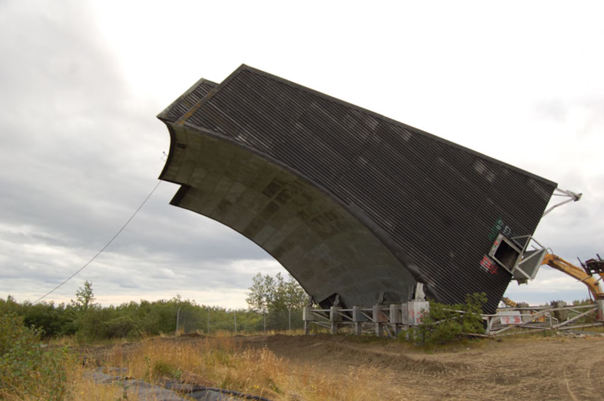
Some White Alice compounds were demolished, some reused, and some became environmental cleanup sites. Historic American Engineering Record teams documented examples such as Rabbit Creek and Boswell Bay with photographs and drawings. The original antennas and buildings can be especially hard to interpret when a relay shared property with an air-defense radar station or when an earlier Army communications reservation carried a similar name.
The station directory therefore separates a documented physical installation from a route name or equipment component. The White Alice and Army repeater relationship at Sheep Mountain remains unresolved. Published coordinates on this site are source-qualified points, not necessarily surveyed boundaries. These cautions are part of the history, not gaps to fill with invented precision.
Chronology
- 1954 The Alaska Communications Study Group seeks a dependable long-distance network for military and civilian traffic.
- 1955 Western Electric receives the original White Alice contract; construction and technical testing advance.
- 1956 Boswell Bay and Neklasson Lake open as the first two original stations.
- 1958-03-26 The original network is dedicated at Elmendorf Air Force Base.
- Late 1950s to 1960s BMEWS rearward routes and Operation Stretchout expand the network.
- 1961 Project Bluegrass extends White Alice communications toward Adak and Shemya.
- 1967 Congress passes the Alaska Communications Disposal Act.
- 1970s Transfer arrangements, satellites, and newer systems progressively change White Alice operations.
- 1977 The Air Force begins closing troposcatter stations, according to the Alaska historical study.
- 1983-08-14 The final White Alice system sale to Alascom is completed, according to the state historical study.
- 1984 The Cape Yakataga to Boswell Bay troposcatter connection goes offline.
Information sources (5)
- WEBHistoric American Engineering Record, Rabbit Creek White Alice Site, HAER AK-23
Source for: system origins, construction, operating methods, phase rosters, transfer context, and historic documentation
- PDFAlaska Office of History and Archaeology, The Coldest Front: Cold War Military Properties in Alaska
Source for: original 31-station breakdown, later routes, project phases, sale and closure chronology, and preservation context
- WEBU.S. Air Force, Cold War Era White Alice Communication System Antenna Felled for a Clean and Safe Dismantling
Source for: 2011 Bethel demolition photograph and its original caption and credit
- WEBLibrary of Congress, Rabbit Creek White Alice Site, HAER AK-23-A
Source for: official photo set for a documented microwave relay installation
- WEBLibrary of Congress, Boswell Bay White Alice Site, HAER AK-23
Source for: official historic photographs and drawings for a troposcatter installation