
Naval Auxiliary Air Facility Eureka (LTA), California
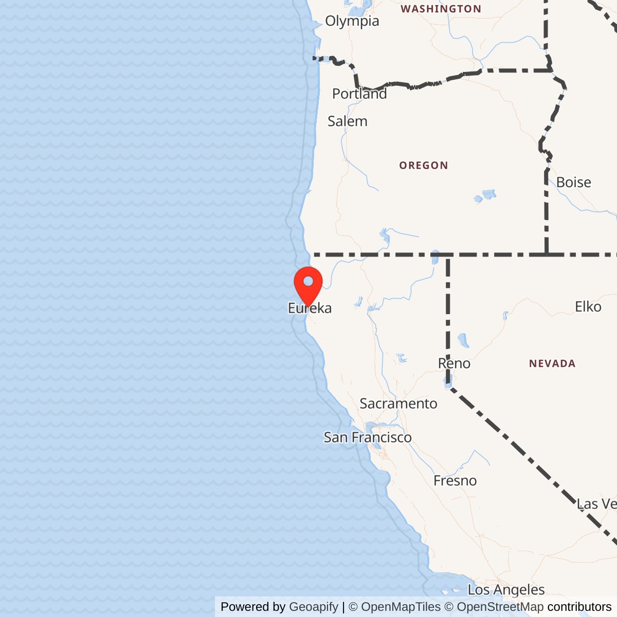
Longitude: -124.2122778
Current Role: Former 429-acre Navy LTA patrol and associated seaplane facility; now city-owned Samoa Field Airport with surviving wartime airship features
Naval Auxiliary Air Facility Eureka was a World War II Navy lighter-than-air operating base on the Samoa Peninsula, the narrow barrier landform separating Humboldt Bay from the Pacific Ocean. The installation was commonly called the Eureka LTA Base, Eureka Auxiliary Field, or Eureka Naval Air Facility. It supported patrol blimps, a small associated seaplane activity, and the coastal-defense system protecting shipping near Humboldt Bay. The property later became Eureka Municipal Airport and survives as Samoa Field Airport.
The installation was distinct from Naval Auxiliary Air Station Arcata at McKinleyville, which was a heavier-than-air station developed around the present California Redwood Coast-Humboldt County Airport. It was also separate from Murray Field east of Eureka and from the earlier Navy Section Base on Humboldt Bay. These activities served related regional-defense purposes, but they occupied different properties and had different command, aircraft, and facility requirements. Combining them would obscure how the Navy distributed wartime aviation and harbor-defense functions around Humboldt Bay.
The official Navy activity inventory identified a Naval Auxiliary Air Facility, lighter-than-air, at Eureka. Humboldt County planning records describe a 429-acre installation near the former Rolph School with a paved blimp mat, mooring circles, conventional runway, and nearby seaplane dock. Those features define a specialized airship outpost rather than a general naval air station. The base did not need the carrier-aircraft training infrastructure found at Arcata because its central task was to stage slow, long-endurance patrol craft close to the northern California shipping lanes.
The facility's parent relationship changed in operational practice even though the completed field was commissioned as an auxiliary of Moffett Field. Navy aircraft-location reports show Airship Patrol Squadron 33, based at Naval Air Station Tillamook, operating a blimp from Eureka before and after formal commissioning. By February 1944 the Eureka aircraft was reported under Airship Patrol Squadron 32 at Moffett Field. The surviving records therefore describe an early ZP-33 detachment followed by integration into the Moffett-centered ZP-32 coastal network.
Strategic and Local Defense Context
Humboldt Bay was a strategically useful but exposed wartime harbor. The bay supported lumber shipping, fishing, coastal traffic, and maritime access to communities on California's northern coast. Its entrance opened directly onto Pacific sea lanes used by tankers, freighters, fishing vessels, and naval craft. The surrounding coastline included long stretches where hostile submarines could approach shipping routes while remaining distant from the major naval aviation concentrations around San Francisco Bay and Puget Sound.The regional threat was not imaginary. Japanese submarines operated off the West Coast during the opening months of the Pacific War, attacked merchant shipping, and created uncertainty about the safety of coastal routes. Even when direct attacks became less likely, the Navy could not assume that the approaches to Humboldt Bay were secure. Persistent surveillance, convoy observation, harbor reporting, and rapid investigation of unidentified contacts remained necessary tasks throughout the period when the United States was moving personnel and materiel through Pacific ports.
The Navy Section Base at Eureka and Coast Guard Station Humboldt Bay formed the earliest organized local maritime-defense elements. The section base coordinated harbor and coastal-security responsibilities, while the Coast Guard maintained lifesaving, patrol, and entrance-control capabilities. The later airship field added an aerial layer that could extend observation far beyond the harbor bar. Its position on the Samoa Peninsula placed aircraft beside the bay entrance and allowed crews to reach patrol areas without crossing the inland terrain surrounding Eureka.
The choice of lighter-than-air aircraft reflected a specific operational problem. K-class blimps could remain airborne for extended periods, travel slowly enough to inspect vessels and suspicious surface activity, and maintain radio contact with shore commands. They could carry search equipment and depth weapons while escorting convoys or investigating submarine reports. Their endurance made them particularly useful for areas where the Navy wanted continuous presence but did not have enough landplanes and airfields to keep every coastal sector under observation.
Construction and Commissioning
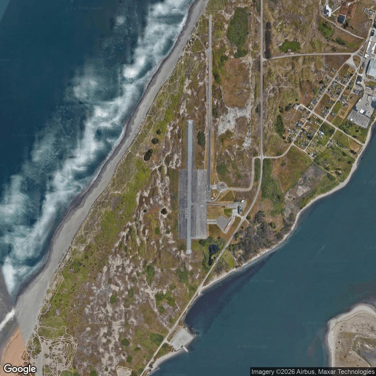
Public planning records state that the Navy built the airfield in July 1943 along the southern part of the Samoa Peninsula project area, immediately north of the Coast Guard station. The field occupied 429 acres near the Rolph School and was commissioned as an auxiliary of Moffett Field. Construction transformed low coastal terrain into a military aviation property with a large paved operating surface, mooring facilities, a conventional runway, roads, utilities, and support areas suitable for an isolated patrol detachment.The documented 700-by-1,400-foot blimp operating mat was the installation's defining feature. Airships did not use runways in the same manner as airplanes. Ground crews needed a broad, relatively unobstructed surface where they could handle the large, wind-sensitive envelope during landing, takeoff, fueling, inspection, and movement to a mast. The mat reduced the problems presented by sand, grass, and wet coastal ground and gave crews enough room to work around the airship without bringing it close to buildings or trees.
Two mooring circles provided controlled areas around fixed or mobile masts. A moored blimp had to turn freely with changing wind direction, which required a clear circular space rather than a conventional parking apron. The circles were operational safety features, not decorative geometry. They kept the envelope, control car, cables, and tail surfaces away from obstacles while ground crews serviced the aircraft and prepared it for another patrol.
The Navy also built a 2,400-foot asphalt runway for conventional aircraft. This runway supported liaison, transport, training, and administrative flights that could not be performed by the blimp detachment alone. County records additionally identify a small seaplane base with a wooden dock at the southern end of the area. The surviving evidence does not establish a separate commissioned command for that water facility, so it is treated as an associated aviation element rather than a second installation.
Secondary histories give 1943-08-06 as the formal commissioning date, but Navy aircraft-location reports prove that operational use began earlier. A ZP-33 blimp was reported at Eureka by February 1943, and local history dates an early patrol by K-47 to 1943-05-22. The apparent conflict is best explained as a distinction between interim detachment operations and completion or commissioning of the permanent NAAF.
Mission Evolution
The field's mission remained centered on coastal antisubmarine patrol, convoy escort, vessel identification, and air-sea rescue support. Its organizational placement evolved as the Navy adjusted the Pacific Coast airship system. Early Eureka operations belonged to ZP-33, whose headquarters and major support base were at Tillamook, Oregon. This arrangement extended southern coverage from the Pacific Northwest while the permanent Eureka facility was being constructed and the Moffett network was still expanding.By early 1944 Navy location reports placed the Eureka aircraft under ZP-32. Moffett Field served as the squadron headquarters, training center, heavy-maintenance base, and principal logistics node for northern and central California airship operations. Eureka became one of the forward locations that allowed ZP-32 to distribute aircraft over a longer coastline. The operating field supplied local berthing, handling, fuel, communications, and routine servicing while major maintenance and squadron administration remained concentrated at Moffett.
The mission was continuous rather than episodic. A patrol field had to be prepared to launch when weather, shipping schedules, or submarine reports required coverage. Ground crews handled the airship in wind, inspected the envelope and control car, serviced engines, loaded equipment, maintained communications, and secured the craft after flight. Aircrews then spent long periods over water observing shipping routes and maintaining contact with shore stations. Most of the base's military value came from this repeated operational cycle.
The field did not become a postwar naval aviation station. As the war ended and the submarine threat disappeared, the Navy dismantled the temporary coastal patrol network. The Eureka LTA and associated seaplane activities closed in October 1945. The site then shifted directly into civilian aviation use, ending its naval mission rather than receiving a new military specialty or permanent active-duty tenant.
World War II Operations
The earliest documented squadron at Eureka was Airship Patrol Squadron 33. Navy aircraft-location records from 1943 repeatedly show one ZNP airship at Eureka while the remainder of ZP-33 operated from Tillamook and other Pacific Northwest locations. The designation ZNP was the administrative aircraft category used in the reports for nonrigid patrol airships. These records are important because they establish an actual deployed aircraft at Eureka rather than merely a planned facility or local recollection.Local history identifies K-47 as the airship that began a patrol from Eureka on 1943-05-22 under Lieutenant W. W. Bemis. The account places this mission before the formal commissioning date, consistent with the Navy location reports showing ZP-33 already operating from Eureka. The patrol illustrates how the Navy used temporary or incomplete bases during wartime expansion. Operational need could place an aircraft and detachment on a site before every permanent facility and administrative action was complete.
A typical Eureka sortie was intended to search the ocean approaches, inspect surface contacts, and remain available for escort or rescue tasks. The aircraft's low speed was useful because crews could circle suspicious vessels and maintain visual observation. Long endurance allowed a single blimp to cover a sector for many hours, while radio communications connected the patrol to Moffett, Tillamook, the section base, Coast Guard personnel, and other naval commands. The blimp therefore functioned as a mobile observation and reporting platform.
K-class patrol airships were equipped for more than passive observation. Wartime examples carried machine guns and depth bombs, and their crews trained to attack a surfaced or detected submarine when conditions allowed. Humboldt County's planning history describes the Eureka blimps as capable of carrying six bombs and having a range exceeding 1,900 nautical miles. Those figures describe the general aircraft capability, not proof that a particular Eureka patrol expended weapons against an enemy contact.
No official record found confirms that an Eureka-based blimp sank or damaged a Japanese submarine. A later local narrative associated the field with a submarine kill near Trinidad, but the claim was not corroborated in Navy operational or loss records reviewed for the history. The event is therefore not presented as fact. The absence of a confirmed engagement does not diminish the patrol mission, whose purpose included deterring attack and making covert submarine operations more difficult.
The patrol system also supported convoy movement and maritime rescue. Airships could accompany merchant or naval vessels through exposed coastal sectors, report hazards, and remain over a disabled craft or survivor position while surface units approached. The nearby Coast Guard station and seaplane dock gave Eureka a local rescue network that could combine aerial observation with boats and conventional aircraft. The facility's design and geography made these cooperative missions practical even though no major site-specific rescue was documented.
Weather shaped every operation at the base. The Samoa Peninsula is exposed to Pacific winds, fog, rain, salt air, and rapidly changing visibility. Blimp handling was especially demanding because the envelope presented a large surface to crosswinds. Mooring circles, a broad operating mat, trained ground handlers, and accurate weather observation were essential. The field's built form reflects the difficulty of operating a large nonrigid airship from a narrow coastal peninsula rather than from a sheltered inland station.
Navy reports show the detachment transition by early 1944. In January, ZP-33 still reported one aircraft at Eureka. By 1944-02-15, ZP-32 reported one at Eureka and two at Watsonville, while ZP-33's aircraft were concentrated at Tillamook. This shift placed both California auxiliary fields under the same Moffett-based squadron and created a more coherent north-south patrol system for the California coast.
The installation remained small compared with Moffett or Tillamook. A single deployed blimp required aircrew, ground handlers, mechanics, radiomen, weather support, supply personnel, security, and administrative assistance, but not a full squadron headquarters. Personnel likely rotated with the assigned aircraft and depended on the parent station for replacements and specialized maintenance. No reliable public roster or peak permanent complement for Eureka was found, so the history does not assign a numerical garrison.
The operational record contains no confirmed fatal aircraft accident, combat casualty, destructive fire, sabotage incident, major spill, or public protest at the NAAF. A postwar Navy blimp accident near Humboldt County occurred after the wartime base had closed and is not treated as an installation event. The most defensible site-specific narrative is therefore the sustained patrol and support mission rather than an isolated disaster or battle.
Units and Organizations
Airship Patrol Squadron 33 was the first documented operating squadron at Eureka. ZP-33 had its headquarters at Tillamook and used auxiliary locations along the Oregon, Washington, and northern California coasts. Aircraft-location reports place one of its blimps at Eureka through much of 1943 and into January 1944. The squadron's role was to maintain antisubmarine patrol coverage over sectors too distant for efficient continuous operation from one main base.Airship Patrol Squadron 32 became the principal parent operational organization for Eureka by February 1944. ZP-32 was based at Moffett Field and used Eureka and Watsonville as forward patrol locations. Moffett provided training, major repair, hangar storage, command, and supply support that the smaller auxiliaries could not duplicate. The arrangement allowed the squadron to place aircraft closer to assigned patrol sectors without constructing a complete airship station at every coastal point.
Fleet Airship Wing organizations provided the higher operational framework. The wing coordinated squadrons, patrol sectors, aircraft availability, and relationships with naval districts and other aviation commands. Eureka's single-airship presence made sense only within this larger system. The field was valuable because the wing could combine its patrol hours with those flown from Moffett, Watsonville, Tillamook, North Bend, Astoria, and other stations to create overlapping coastal coverage.
The Coast Guard station immediately south of the NAAF was a major local partner rather than a Navy tenant unit. Coast Guard crews understood Humboldt Bay's bar, surf, weather, and maritime traffic. The county history explicitly states that the LTA base worked with the Coast Guard station. That relationship connected the airborne patrol to local rescue craft, harbor information, and entrance-control activity.
The Humboldt Bay Navy Section Base was another distinct partner. It represented the naval district's harbor-defense and local security structure and predated the airship field. The section base should not be counted as a unit assigned to NAAF Eureka, but its communications and maritime awareness would have supported the same regional defense mission. The NAAF added reach beyond the harbor, while the section base and Coast Guard maintained local control and response capability.
Facilities and Physical Layout
The 429-acre naval tract lay on low coastal land between Humboldt Bay and the Pacific. Its size allowed the Navy to separate the airship operating surface, mooring circles, runway, support buildings, roads, and associated seaplane activity. The surrounding dunes and open land reduced obstruction hazards, but the narrow peninsula also exposed the station to wind, salt, fog, flooding, and tsunami risk. The installation's physical layout was therefore a compromise between clear airship handling space and a difficult marine environment.The paved blimp mat measured approximately 700 by 1,400 feet. This rectangular surface gave ground crews a central working area for landing and launching the airship and for moving it toward a mast. Unlike an airplane apron, the mat had to accommodate an aircraft whose envelope was much longer and more vulnerable to wind than its control car. Its large dimensions were directly tied to the handling characteristics of the K-class craft.
The two mooring circles were broad cleared areas centered on masts. Their circular form allowed a secured airship to weathervane as wind direction changed. Ground crews could approach the control car, engines, and envelope while maintaining clear space around the tail and cables. One northern circle remained sufficiently legible in later cultural-resource studies to convey the property's wartime significance, making the former operational geometry one of the site's most important surviving historical features.
The 2,400-foot asphalt runway gave the base a conventional aviation capability. Small airplanes could deliver personnel, parts, mail, and administrative traffic without requiring the blimp to perform duties outside its patrol mission. The current Samoa Field runway is longer and reflects postwar airport modification, so its dimensions should not be read as an unchanged wartime facility.
The seaplane facility at the southern end included a wooden dock on Humboldt Bay. It worked in conjunction with the LTA base and Coast Guard station, giving the local aviation complex direct water access. The available public record does not identify its aircraft complement, commissioning order, or independent command status. It is therefore described as an associated facility whose precise boundary and administrative relationship remain unresolved.
Support facilities would have included operations and communications spaces, fuel storage, maintenance shops, power and utility systems, crew quarters or temporary housing, security positions, fire protection, and vehicle access. No complete wartime station plan or building inventory was found in the reviewed public sources.
Role in the Wider Military Network
Eureka filled the northern California gap between the San Francisco Bay airship complex and Pacific Northwest bases. Moffett Field was too distant to keep every patrol efficiently over Humboldt Bay, while Tillamook's aircraft also had broad responsibilities farther north. A forward operating field on the Samoa Peninsula reduced transit time and placed an aircraft beside the patrol sector. This geographic economy was the installation's principal contribution to the larger network.The field's changing squadron association demonstrates how the Navy managed that network. ZP-33 initially extended operations south from Tillamook, then ZP-32 incorporated Eureka into a Moffett-centered group that also included Watsonville. The shift did not change the physical location or basic mission. It changed which squadron supplied the aircraft, crews, maintenance support, and operational reporting chain.
Eureka also connected naval aviation to harbor and coastal-defense organizations. The Coast Guard station, Navy Section Base, seaplane dock, local radio links, and surface vessels gave the airship crew sources of information and potential rescue or interception support. The blimp could observe far offshore, but it depended on shore stations and surface craft to turn reports into coordinated action. The base was therefore a sensor and patrol node rather than an independent combat command.
The installation belonged to a nationwide wartime pattern of auxiliary airfields. Major stations concentrated hangars, schools, maintenance, supply, and headquarters, while smaller auxiliaries placed aircraft closer to patrol sectors. Watsonville performed the same general function south of Moffett, while Eureka extended coverage northward. The system gave the Navy persistent coastal presence without reproducing Moffett's expensive infrastructure at every location.
Closure, Transfer, Environment, and Current Status
The Navy closed the blimp base on 1945-10-15, according to the City of Eureka's community history, and transferred the aviation property for civilian use. Humboldt County records describe the LTA and associated seaplane base as closing in October 1945. This date represents mission termination and property conversion rather than a prolonged caretaker phase. No later active-duty naval unit or recurring postwar military mission at the field was identified.The former NAAF became Eureka Municipal Airport and later Samoa Field Airport. Civil use preserved the basic aviation function but changed the scale and configuration of the property. The City of Eureka remains the owner of the public-use airport, which is in unincorporated Humboldt County. Current federal airport information identifies the field as O33.
The present airport has one asphalt runway measuring approximately 2,700 by 60 feet and operates as a small, unattended general-aviation field. Current planning records also describe aircraft parking, lodging or hospitality facilities, and a drag strip used for recreational racing. These activities occupy part of the former naval landscape, but the present airport property should not automatically be equated with the full 429-acre wartime tract.
Cultural-resource studies found that a portion of the former NAAF retained historical significance under California Register criteria associated with World War II coastal defense and specialized airship design. The northern mooring circle remains readable enough in the landscape to explain how the base functioned. This survival is important because many small wartime auxiliary facilities lost their defining operational features completely after disposal.
Chronology
- 1941-12-08 The Navy Section Base and other Humboldt Bay defense organizations entered wartime operations following the attack on Pearl Harbor.
- 1942 The Navy expanded West Coast lighter-than-air patrol planning to cover gaps between major bases.
- 1942-12 Airship Patrol Squadron 33 began operations from Naval Air Station Tillamook.
- 1943-02-24 A Navy aircraft-location report recorded one ZP-33 patrol airship at Eureka.
- 1943-03-11 Navy records continued to show a ZP-33 airship operating at Eureka.
- 1943-05-05 ZP-33 reported two airships, one at Eureka and one at Tillamook.
- 1943-05-22 Local history records K-47 beginning an early patrol from Eureka under Lieutenant W. W. Bemis.
- 1943-06-15 A Navy aircraft-location report continued to list a ZP-33 airship at Eureka.
- 1943-07 Humboldt County records date construction of the permanent Navy airfield on the Samoa Peninsula to this month.
- 1943-08-06 Secondary station histories give this as the formal commissioning date of Naval Auxiliary Air Facility Eureka.
- 1943-08-09 Navy aircraft-location records continued to identify an airship at Eureka during the commissioning period.
- 1943-10-19 ZP-33 reported one of its airships at Eureka and the remainder at Tillamook.
- 1943-11-02 Navy records still showed the ZP-33 Eureka detachment in operation.
- 1944-01-11 ZP-33 continued to report one aircraft at Eureka shortly before the squadron transition.
- 1944-02-15 Navy records placed one Eureka airship under ZP-32 at Moffett Field and concentrated ZP-33 at Tillamook.
- 1944-07-04 Navy aircraft-location reporting continued to list ZP-32 airship operations at Eureka.
- 1944 Eureka functioned as a Moffett-supported forward patrol site for northern California coastal coverage.
- 1945 The NAAF continued patrol, escort, and rescue-readiness activity as the Pacific war approached its end.
- 1945-08-14 Japan accepted Allied surrender terms, ending the strategic emergency that had sustained the coastal airship network.
- 1945-09 The Navy's lighter-than-air station summary places the end of Eureka auxiliary operations in this period.
- 1945-10-15 The Navy closed the Eureka blimp base and transferred the property for civilian airport use.
- 1945-10 Humboldt County records state that the associated seaplane activity also closed.
- 1945 The former NAAF was recommissioned for public use as Eureka Municipal Airport.
- 1946 Postwar Navy aviation planning no longer listed Eureka as an active lighter-than-air facility.
- 1950s Civil airport operations continued while naval support buildings and specialized features were altered or removed.
- 1993 Humboldt County airport planning included Samoa Field among the region's public-use airports.
- 2015 Eureka planning documents described Samoa Field as a city-owned public-use airport on the peninsula.
- 2018 A county cultural-resource study documented the 429-acre Navy base history and surviving mooring-circle significance.
- 2021 Coastal planning records described the airport as city-owned, with one paved runway, aircraft parking, hospitality uses, and a recreational drag strip.
- Present Samoa Field Airport remains a public general-aviation facility preserving part of the former NAAF landscape.
Sources & References
- WEB U.S. Navy, "U.S. Naval Activities, World War II, by State: California" Source for the official separate listing of Naval Auxiliary Air Facility (LTA), Eureka.
- WEB Naval History and Heritage Command, "Building the Navy's Bases in World War II, Volume I" Source for West Coast lighter-than-air base development and antisubmarine patrol doctrine.
- PDF Naval History and Heritage Command, "Pre-World War II Blimps and Evolution of the K-Class" Source for Eureka's early ZP-33 operations and Navy airship development.
- PDF Naval History and Heritage Command, "Fleet Airship Wings and ZP-32 Operations" Source for Moffett-based ZP-32 operations and the California auxiliary network.
- PDF Naval History and Heritage Command, "Location of U.S. Naval Aircraft, 1943-02-24" Source for the earliest reviewed primary record of a ZP-33 airship at Eureka.
- PDF Naval History and Heritage Command, "Location of U.S. Naval Aircraft, 1943-05-05" Source for the ZP-33 detachment at Eureka during early operations.
- PDF Naval History and Heritage Command, "Location of U.S. Naval Aircraft, 1943-10-19" Source for continued ZP-33 airship operations at Eureka after commissioning.
- PDF Naval History and Heritage Command, "Location of U.S. Naval Aircraft, 1944-01-11" Source for the last reviewed ZP-33 reporting period at Eureka.
- PDF Naval History and Heritage Command, "Location of U.S. Naval Aircraft, 1944-02-15" Source for transfer of the reported Eureka detachment to ZP-32.
- WEB County of Humboldt, "Samoa Peninsula Wastewater Project Draft EIR, Cultural and Tribal Cultural Resources" Source for acreage, construction, facilities, seaplane association, closure, and current-airport succession.
- WEB City of Eureka, "Community Background Report" Source for the 1945-10-15 Navy closure and transfer to the city for general aviation.
- WEB County of Humboldt, "2021 Airport Land Use Compatibility Plan" Source for current Samoa Field runway, airport configuration, and land-use context.
- WEB Federal Aviation Administration via AirNav, "O33, Samoa Field Airport" Source for current representative coordinates, ownership, status, and runway dimensions.
- PDF California Coastal Commission, "Samoa Peninsula Wastewater Project Staff Report" Source for current airport ownership, facilities, surrounding uses, and coastal-hazard context.
- WEB Clarke Historical Museum, "Civil Defense in Humboldt County During World War II" Source for the distinct Navy Section Base and Humboldt Bay defense context.
- WEB Lost Coast Outpost and Humboldt Historian, "When Blimps Once Dotted the North Coast Skies" Source for local K-47 patrol history, personnel detail, and archival photographs.
- WEB Airship and Blimp Resources, "Airship Patrol Squadron ZP-33" Source for the broader Tillamook squadron auxiliary-base network.