
AN/FPQ-16 PARCS: Perimeter Acquisition Radar Attack Characterization System
Equipment designation: AN/FPQ-16
Common name: PARCS
Type: Fixed UHF phased-array
radar
Location: Cavalier Space Force Station, North Dakota
Primary missions: Ballistic-missile warning, attack
characterization, and space-object tracking
Identification and Scope
AN/FPQ-16 is the Joint Electronics Type Designation System identity applied to the Perimeter Acquisition Radar Attack Characterization System, commonly PARCS, at Cavalier Space Force Station in northeastern North Dakota. It is a fixed, single-face, electronically steered UHF phased-array radar built by the United States Army for the Safeguard anti-ballistic missile system and retained after Safeguard ended. The surviving radar became a United States Air Force missile-warning sensor in 1977 and later a United States Space Force system. No second operational AN/FPQ-16 installation has been verified.
The equipment and the installation are related but not interchangeable records. The radar began as the Perimeter Acquisition Radar portion of the geographically dispersed Stanley R. Mickelsen Safeguard Complex. Its physical plant near the former community of Concrete was later called Concrete Missile Early Warning Station, Cavalier Air Force Station, and Cavalier Space Force Station. The separate Missile Site Radar complex near Nekoma and the remote Sprint launch sites were fellow Safeguard components, not AN/FPQ-16 locations.
PARCS is not a mechanically rotating search antenna and does not have multiple outward-looking faces. Its north-facing array forms and steers radar beams without moving the building or antenna. That architecture supported rapid search, verification, discrimination, and tracking within the fixed face's field of regard. It also explains both the radar's great strength toward the polar approach and the importance of stating azimuth and elevation limits instead of implying full 360-degree coverage.
Designation, Expansion, and Name Control
The original Army name was Perimeter Acquisition Radar, or PAR. After the Air Force transition, official sources used PAR Attack Characterization System, Perimeter Acquisition Radar Characterization System, Perimeter Acquisition Radar Attack Characterization System, and Enhanced PARCS. Current Space Force usage favors Perimeter Acquisition Radar Attack Characterization System. These variations describe the same surviving Cavalier radar through changing missions and modernization states; they are not evidence of several separate AN/FPQ-16 sets.
The expanded title carries operational meaning. Perimeter Acquisition described Safeguard's distant acquisition of incoming objects before they entered the Missile Site Radar's engagement volume. Attack Characterization reflects the later warning task: derive launch and predicted-impact information, identify the number and type of objects within coverage when possible, and forward time-critical assessment to the national warning system. The common acronym remained PARCS even where a source omitted the word Attack.
AN/FPQ-16 must not be confused with AN/FPQ-15. AN/FPQ-15 is a C-band precision tracking designation associated with mechanically steered dish systems, including Ascension Island radar 12.15 and a later official attribution in Australia. AN/FPQ-16 is a one-of-a-kind UHF building-integrated phased array in North Dakota. Adjacent designation numbers do not indicate common frequency, antenna, manufacturer, mission, or development lineage.
Strategic Origins
PAR grew from the United States Army's effort to defend the nation against intercontinental ballistic missiles. Nike Zeus had demonstrated a complete radar, computer, interceptor, and nuclear-warhead engagement concept, but planners expected larger attacks, decoys, and multiple independently targetable reentry vehicles to overwhelm a system that handled targets in a more serial fashion. Nike-X therefore emphasized faster computers, phased-array radars, and a layered interceptor defense able to manage many objects at once.
Bell Laboratories and the Army began examining phase-controlled scanning arrays in 1960. The Multifunction Array Radar prototype at White Sands Missile Range established the foundations that mattered to PAR: high power, broad bandwidth, rapid electronic steering, centralized digital control, and simultaneous handling of search and tracking functions. The Army history emphasizes that an electronically formed beam could be redirected in millionths of a second, removing the inertia and settling time of a large rotating antenna.
The earliest PAR concept was a less hardened VHF warning adjunct, but the Sentinel deployment decision of 1967 changed the requirement. The operational radar became a hardened UHF sensor responsible for initial detection, discrimination, and long-range tracking. When Sentinel's mission shifted from city defense to the Safeguard defense of strategic missile forces, PAR retained its northern surveillance role while feeding the shorter-range, four-face Missile Site Radar that controlled Spartan and Sprint engagements.
From Nike-X to Sentinel and Safeguard
Nike-X originally envisioned the more capable L-band Multifunction Array Radar as the principal sensor. Cost and deployment studies favored a less expensive perimeter radar derived from demonstrated technology. Army historians describe PAR as comparable to the White Sands MAR-I configuration and built with available UHF components, which led planners to classify much of its technology as available rather than requiring a full operational prototype. The only tactical PAR was consequently constructed in North Dakota without a complete duplicate prototype elsewhere.
Sentinel, announced in 1967, proposed a broad network of PAR and Missile Site Radar installations. Publicly announced locations included Boston, Detroit, Seattle, and Grand Forks, with other MSR locations. Political opposition, cost, and changing strategy prevented that network from becoming operational. President Richard Nixon redirected the effort as Safeguard in 1969, placing the first deployment around the Minuteman fields associated with Grand Forks Air Force Base and authorizing a second site near Malmstrom Air Force Base.
The 1972 Anti-Ballistic Missile Treaty permitted each signatory two ABM deployment areas, later reduced to one by the 1974 protocol. The United States selected its ICBM-defense site in North Dakota. Construction at the Montana Safeguard location stopped at an early stage and was removed or buried. The treaty constrained the deployed architecture, but it did not itself order the North Dakota system's immediate closure. Congressional judgments about cost, effectiveness against evolving Soviet MIRV forces, and the limited value of operating the completed system drove the 1975 and 1976 deactivation decisions.
The North Dakota Complex
The deployed Safeguard installation was a network rather than one compact base. The PAR site stood near Concrete in Pembina County. The Missile Site Radar, command building, and central interceptor field stood near Nekoma, while remote Sprint launch sites near Hampden, Dresden, Concrete, and Fairdale extended short-range protection. The Army formally named the distributed tactical facilities the Stanley R. Mickelsen Safeguard Complex on 21 June 1974 to emphasize their geographical integration.
PAR's task was to watch the northern approach, detect and verify ballistic objects at long distance, develop tracks, and pass target data to the Missile Data Center. Spartan could engage objects outside the atmosphere, while the much faster Sprint provided lower-altitude terminal defense. The Missile Site Radar tracked targets and interceptors and generated guidance commands. PAR therefore did not launch or guide an interceptor by itself; its long-range acquisition and tracking data gave the downstream engagement system time and target structure.
The Army stationed the United States Army Surveillance Battalion, Grand Forks, at the PAR site. Army history gives the battalion an authorized population of about 400 and a mission of long-range surveillance and early warning. The United States Army Safeguard Command, Grand Forks, coordinated the broader defense. Although Army organizations manned and administered the complex, operational control of the netted system passed through Continental Air Defense Command and later Aerospace Defense Command, showing that the Army weapon and continental aerospace-warning structure were connected from the beginning.
Construction and Acceptance
Construction began in 1970 amid severe northern Plains conditions. The radar building required a massive nuclear-hardened shell, a sloping north face, internal radio-frequency equipment, extensive computer rooms, cooling, electromagnetic-pulse protection, and a separate hardened power plant connected by tunnel. Historic American Engineering Record documentation identifies Ammann & Whitney, the United States Army Corps of Engineers, and General Electric among the principal design and equipment contributors, while Morrison-Knudsen and associates performed major construction.
The principal PAR building is approximately 128 feet high, 198 feet wide, and 208 feet long. Army accounts describe roughly 58,000 cubic yards of concrete and 17 million pounds of reinforcing steel. Its base occupies approximately one acre within a PAR installation documented at about 279 acres during the Safeguard period. A later Air Force account gives Cavalier Air Force Station as 278 acres. The one-acre building footprint, 278-acre current installation figure, and 279-acre historical PAR-site figure are different measurements and should not be combined.
The separate hardened power plant began construction in April 1970. Five Cooper-Bessemer diesel-generator units supplied a combined installed capacity of 15 megawatts. The plant incorporated switchgear, transformers, protected communications, and electromagnetic-pulse shielding, and a hardened tunnel connected it to the radar building. The Army Corps account records completion on 8 November 1972 at an approximate cost of $40.703 million. The generating plant was not merely backup convenience; Safeguard required the radar to survive disrupted commercial power during attack.
The complex reached equipment readiness on 1 October 1974, meaning construction and equipment installation were complete enough for formal Army acceptance and dedication. This was not the same as tactical initial operating capability. Integrated testing, crew qualification, communications certification, nuclear surety work, and missile installation continued. Safeguard reached initial operating capability on 1 April 1975 and full operational capability on 28 September 1975.
Technical Architecture
AN/FPQ-16 is a pulsed UHF phased-array radar. The transmitter chain generates short, high-power radio-frequency pulses and distributes their energy to thousands of radiating elements across the sloped antenna face. Controlled phase differences among elements cause the wave fronts to reinforce in one selected direction and cancel in others. Adjusting those phase relationships redirects the beam electronically while the array remains physically fixed.
The receiver measures the time between transmission and returned energy to determine slant range. Monopulse and array-processing techniques estimate angular position, while repeated measurements allow the computers to form tracks, estimate velocity, reject false returns, discriminate among objects, and predict future position or impact. Because a ballistic missile can release warheads, penetration aids, booster debris, and other objects, PAR's value depended on managing a scene containing many returns rather than reporting only that one target existed.
The radar's control system assigned time and energy among search, verification, tracking, calibration, and test functions. A phased array can place successive pulses in different directions, revisit established tracks according to priority, and use different dwell strategies without waiting for a dish to rotate. That flexibility made one fixed face a multifunction sensor, but it did not eliminate resource limits. Transmitter power, element condition, processor capacity, interference, target geometry, and competing track demands still constrained performance.
The original central computer and logic system occupied rows of large cabinets. A 2012 official account described 48 legacy cabinets replaced by a modern computer and emulation software occupying a much smaller room. Emulation preserved required interfaces and behavior while removing hardware that had become difficult to sustain. That change illustrates how the surviving system remained AN/FPQ-16 even though its processors, controls, displays, power regulation, and software evolved substantially after the 1970s.
Antenna Face and Field of Regard
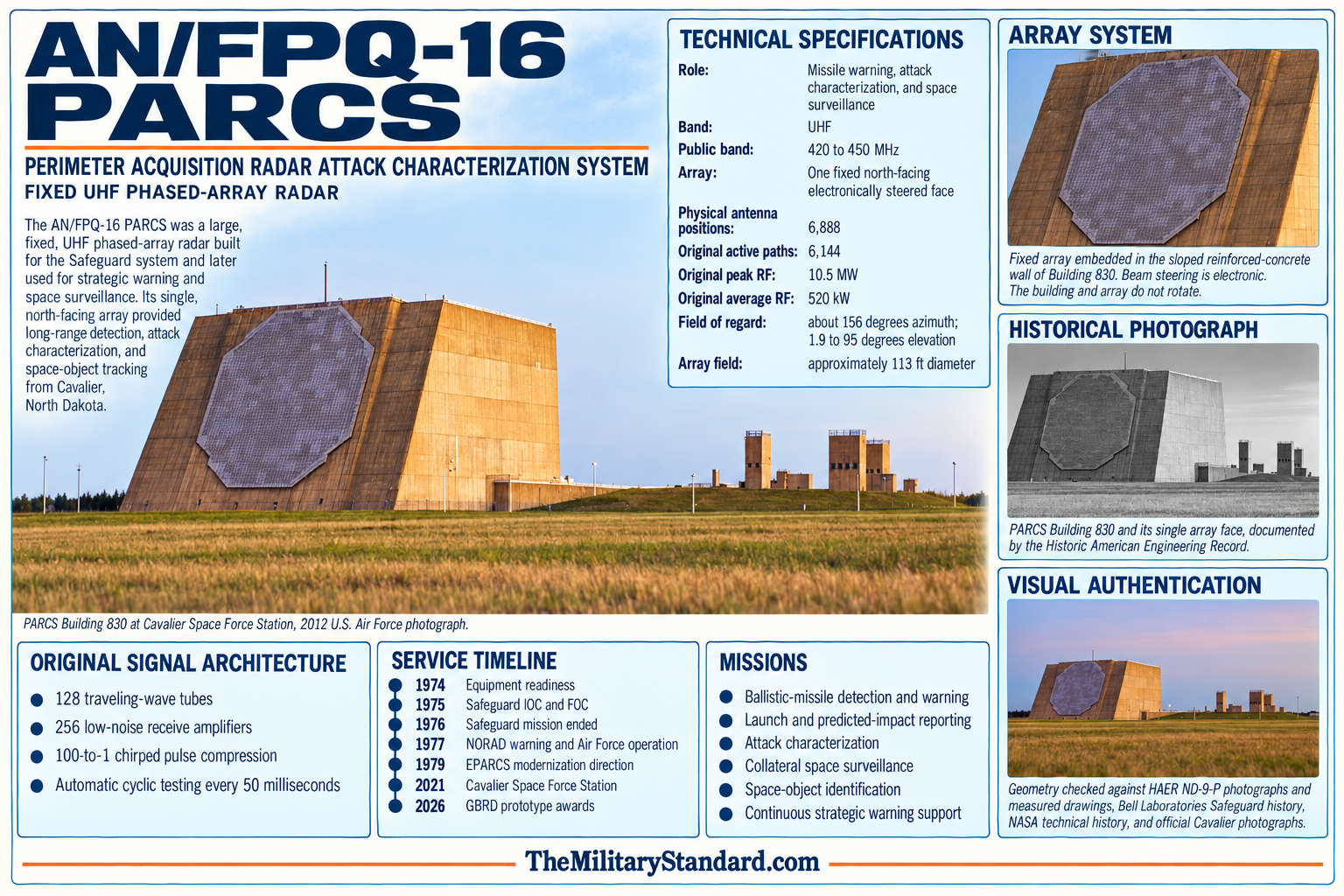
The visible array is built into the large north-facing sloped wall. The Air Force's 2011 equipment reference gives maximum azimuth field of regard of approximately 156 degrees, elevation coverage from about 1.9 degrees to 95 degrees, and approximate range of 2,300 statute miles. For the aperture, the controlling engineering description is 6,888 physical external element positions, including 6,144 originally active transmit and receive paths and several hundred electrically representative dummy elements. These are design and installed-aperture counts, not a claim that every active path is operating in a current configuration.
Historic photographs show that the face is not a flat painted panel. Thousands of antenna assemblies occupy a large circular area contained within the lighter-toned section of the sloping reinforced-concrete wall. Library of Congress documentation includes close views of a radar element and coaxial arrangement, as well as an as-built typical antenna-section drawing. Those details distinguish the surviving array from a rotating dish radar.
The fixed northern orientation reflects the original threat geometry. Intercontinental trajectories from the Soviet landmass toward North America approached through polar regions, and the Grand Forks Minuteman fields lay behind the defended sector. In the later warning mission, the broad northern field continued to cover important ICBM and submarine-launched ballistic missile trajectories. The system cannot look equally well south through the back of the building, so network coverage depends on other sensors with different positions and faces.
Antenna Element Count Reconciliation
The 1975 Bell Laboratories project history prepared for the Army states that the north-facing wall supported a phased array of 6,888 antenna elements. Its subsystem description independently establishes the active feed count. The transmitter had 128 traveling-wave tubes, and each tube fed two 24-element subarrays, giving 128 times 48, or 6,144 active transmit paths. The receiver had 256 low-noise amplifiers, each serving a 24-element receive subarray, again giving 256 times 24, or 6,144 active receive paths. Because PAR used one common transmit and receive aperture, these calculations describe the same 6,144 active physical positions rather than separate transmit and receive faces.
The Historic American Engineering Record confirms that workers installed approximately 6,888 external elements on the A-wall and that several hundred were dummies placed so active elements would see the same electrical environment. NASA's history of orbital-debris work likewise describes PARCS as an array of 6,144 north-facing sensors. Subtracting the independently supported active count from the installed-face total gives 744 dummy or nonfed edge positions. The figure 744 is a transparent arithmetic inference from the two documented totals; the reviewed sources do not directly label a list of exactly 744 units as dummies.
A 2017 Army public-history article states 6,192 elements. That value is preserved as a published error but no longer treated as an equally supported configuration. It conflicts with the contemporaneous Bell Laboratories total, the HAER installed count, the NASA active-sensor count, and both independent transmitter and receiver feed calculations. No primary configuration record was found showing a 6,192-element PAR aperture. The controlled equipment statement is therefore 6,888 physical external positions, 6,144 originally active feed paths, and an inferred 744 dummy positions. Current failed, disabled, spare, or modernized paths remain a separate configuration-health question.
Frequency, Power, and Cooling
Public official sources identify PARCS as a UHF-band radar. A National Telecommunications and Information Administration spectrum compendium places the Cavalier PAR among the important federal radar installations using the 420 to 450 MHz band, and the United States and Canadian coordination rules specifically protect the radar at Concrete from interference. These records support a public allocation and operating-band statement, but they do not disclose a current assigned channel, channel plan, tuning limits, waveform schedule, or protected operating mode.
Army history gives an original design capability of 10.5 megawatts peak and 520 kilowatts average. A 2012 Air Force article describes 16 transmitters capable of 25 megawatts cumulatively and more than 100 traveling-wave tubes, each capable of 200 kilowatts peak pulsed radio-frequency output. These figures do not measure the same point or condition. Original array peak and average values, the sum of transmitter capability, individual-tube ratings, and effective radiated power are distinct quantities.
The traveling-wave tubes and associated high-voltage equipment create severe heat and maintenance demands. The Air Force reported tube operating temperatures as high as 1,100 degrees Celsius and an approximate cost of $130,000 per tube in the 2012 configuration. New filament regulators and vacuum ion pumps reduced damaging conditions and extended component life by up to 25,000 hours. The building's mechanical plant included three 660-ton chillers and heat exchangers for precise water-temperature control, showing that cooling was part of the radar architecture rather than ordinary building air conditioning.
Technical Baselines by Era
AN/FPQ-16 has no single timeless public technical specification. The Safeguard design record describes the original tactical radar, the 1976 space test describes one experimental observation geometry, the 2011 and 2012 Air Force publications describe later operational capabilities, and current budget records describe sustainment requirements rather than detailed signal parameters. The values can be reconciled when each is labeled by date, measurement boundary, mission, and source instead of being combined into a synthetic present-day configuration.
The 1974 to 1976 tactical baseline used a common UHF transmit and receive aperture. Sixteen groups of eight traveling-wave tubes produced 128 transmitter channels, each feeding two 24-element subarrays, while 256 low-noise transistor amplifiers each served one 24-element receive subarray. A common exciter generated a chirped pulse with a 100-to-1 compression ratio. The public Bell Laboratories history calls the combined peak radiated power multimegawatt and the duty cycle unusually high, while an Army summary separately gives 10.5 megawatts peak and 520 kilowatts average for the original design.
Original beam and control details are unusually well documented. The radar could change both operating frequency and beam direction rapidly, used an asymmetrical transmit phase taper at low pointing angles to reduce ground-directed sidelobes, and used receive amplitude tapering to reduce near-in sidelobes and interference. The Digital Data Group, Radar Data Processor, and Beam Steering Computer controlled timing and pointing through two simultaneously operating channels. Automatic cyclic tests ran every 50 milliseconds, with battle-performance tests interleaved with tactical programs and commanded tests available for beam-shape and beam-forming alignment work.
The Army's acceptance record says electrical performance met or exceeded required values and that the overall radar performed about 4 dB better than specified because of higher transmitter power, better receiver sensitivity, and slightly higher antenna gain. Exact classified requirements, angle accuracy, range accuracy, discrimination thresholds, and simultaneous track limits were not released in the public chapter. Passing or exceeding a classified requirement cannot be converted into an invented numerical accuracy or capacity value.
NASA's account of the 31 July to 1 August 1976 small-satellite experiment describes 6,144 north-facing sensors tracking many objects simultaneously within a 65-degree-wide sector extending about 4,000 kilometers north. The radar detected 8,445 objects during the roughly 12-hour experiment, but that total is accumulated detections rather than a simultaneous-track capacity. The 65-degree experimental sector is likewise not the same measure as the approximately 156-degree maximum azimuth field of regard published by the Air Force in 2011.
The dated 2011 Air Force baseline gives a single face, approximately 156 degrees maximum azimuth, 1.9 to 95 degrees elevation, about 2,300 statute miles of range, and 6,888 physical face elements. A separate 2012 operational account reports nearly 3,300 nautical miles for tracking near-Earth objects, up to 100,000 observations per day, and coverage of about 75 percent of catalogued orbiting objects. These range and workload figures reflect different missions, targets, thresholds, geometry, and reporting definitions, so none should be treated as a universal detection radius or simultaneous-track limit.
The 2012 processing and transmitter description belongs to another configuration boundary. Forty-eight legacy computer cabinets had been replaced by a much smaller modern computer running emulation software, and the article described 16 transmitters with a cumulative capability of 25 megawatts plus more than 100 traveling-wave tubes capable of 200 kilowatts peak pulsed output each. The article does not establish that all tubes transmit simultaneously at rated output or that cumulative transmitter capability equals array peak radiated power, effective radiated power, facility consumption, or the 1970s design rating.
The current public baseline is intentionally less detailed. Space Force documents retain the single-face multifunction UHF identity and the warning, attack-characterization, and space-domain-awareness missions, while fiscal year 2026 budget material states a 98-percent operational-availability requirement and identifies a mixture of unique custom-built and increasingly difficult-to-maintain components. Exact current frequencies, waveform library, duty factors, beam schedules, processor configuration, accuracy, sensitivity, discrimination performance, track capacity, and path-health figures remain unverified in releasable official sources.
Hardening and Survivability
Safeguard was intended to function in a nuclear environment. Reinforced concrete protected equipment and personnel against blast, while embedded steel and specialized penetrations helped control electromagnetic pulse and radio-frequency interference. Air intakes, exhausts, doors, utilities, communications paths, and the power tunnel required protective design. The building's unusual shape reflects both array geometry and hardening needs, not an aesthetic attempt to resemble a pyramid.
Hardening also shaped internal layout. Transmitter areas, operations rooms, central logic, maintenance spaces, utilities, and communications occupied protected zones within the mass. The HAER survey documents the Perimeter Acquisition Radar Operations Center, transmitter rooms, traveling-wave-tube storage, maintenance and repair center, mechanical spaces, and antenna sections. Those records provide the strongest open-source basis for reconstructing interior functional relationships.
The radar was designed for degraded conditions, but nuclear hardening should not be described as invulnerability. A sufficiently close or repeated attack, loss of fuel, blocked cooling, damaged communications, or internal equipment failure could prevent useful operation. The value of hardening was to increase the probability that the sensor would continue long enough to warn, characterize, and support a response during the most demanding phase of attack.
Safeguard ABM Operations
The PAR tracked its first satellite on 20 July 1973 according to one Army public history, while the Army's published chronology records 5 August 1973. The difference may represent an initial test and a later formally recorded event, but the reviewed sources do not explain it. Both dates are preserved. Satellite tracking before full tactical readiness demonstrated that the array, computer, and tracking chain could acquire and follow real orbital objects and foreshadowed the radar's later collateral mission.
During Safeguard operations, PAR searched outward, initiated tracks, and transmitted data to the Missile Data Center associated with the MSR site. The netted system linked North Dakota to the Ballistic Missile Defense Center in Cheyenne Mountain. Exercises and operational-experience work tested communications, software management, command procedures, nuclear surety, contractor maintenance, and the ability to move from surveillance to interceptor engagement.
The complex achieved full operational capability on 28 September 1975, three days early. It then included 30 Spartan and 70 Sprint interceptors distributed among the central and remote fields. The House Appropriations Committee recommended deactivation that same day, and the House agreed on 2 October. Congress ultimately funded continued PAR operation but directed rapid termination of the remainder. The Joint Chiefs ordered the BMD mission ended on 10 February 1976, stopping MSR radiation and interceptor launch capability.
Transition from Interceptor Sensor to Warning Radar
PAR survived because its long-range polar coverage had value outside the terminated ABM system. Congress explicitly excepted operation and maintenance of PAR from the deactivation restriction. The radar could supplement national missile warning while the remaining Safeguard missile and MSR facilities entered deactivation. That decision transformed a specialized acquisition sensor into a permanent warning asset rather than merely preserving an empty Cold War building.
The detailed Army chronology is more precise than later summaries. With its link to the NORAD Combat Operations Computer complete, PAR joined the NORAD early-warning sensor system on 3 January 1977. The Air Force assumed tactical responsibility on 22 August. The entire PAR complex transferred to the Air Force on 1 October as the PAR Attack Characterization System, and space-track capability became operational in December.
The site was first called Concrete Missile Early Warning Station under Air Force operation. The name referred to the nearby settlement, not construction material. When the Concrete post office closed in 1983, the installation became Cavalier Air Force Station, using the name of the larger town about 12 to 15 miles east. On 30 July 2021 it became Cavalier Space Force Station. The radar remained at the same PAR site through those changes.
Missile Warning and Attack Characterization
PARCS continuously watches its field of regard for intercontinental and submarine-launched ballistic missiles directed toward North America. Detection starts a sequence of verification, tracking, and trajectory estimation. Launch and Predicted Impact data describe where a threat appears to have originated, where it is heading, and when effects may occur. That information supports North American Aerospace Defense Command, United States Strategic Command, regional combatant commanders, and national decision-makers.
Attack characterization is more demanding than a simple alarm. The radar must separate credible ballistic objects from clutter and nonthreat events, estimate the number and type of objects entering coverage when possible, maintain tracks, and report with very low delay. The Air Force has described PARCS as able to provide earliest and next time-of-impact metrics and as a source of attack assessment for national command decisions. Those statements should not be expanded into a claim that one radar independently determines the entire national attack picture.
PARCS contributes to the Integrated Tactical Warning and Attack Assessment system. It works alongside infrared launch-detection satellites, other ground-based early-warning radars, command centers, communications networks, and human assessment. Correlation across independent sensors reduces false warning and improves confidence. The network also covers sectors that the single north-facing Cavalier array cannot observe.
Space Surveillance and Space Domain Awareness
The radar's secondary mission is collateral space surveillance. PARCS receives tasking or detects objects within coverage, generates metric observations, and forwards data for catalog maintenance, orbit determination, event assessment, and space-object identification. Current official material states that it sends satellite-track data to the Combined Space Operations Center. Earlier sources refer to the Joint Space Operations Center, Cheyenne Mountain, the Space Control Center, or the 18th Space Control Squadron as organizations changed.
Official percentages vary with catalog size, tasking, definitions, and date. The Space Force fact sheet says PARCS monitors and tracks more than half of all Earth-orbiting objects. A 2012 Air Force article said it could track 75 percent of cataloged objects and contributed nearly 40 percent of Air Force phased-array observations, up to 100,000 per day. A 2019 official account again cited about 100,000 data points daily. These are dated workload and coverage statements, not a permanent fraction of all objects.
The space mission benefited from a radar designed to distinguish and track many ballistic objects quickly. PARCS has supported launch detection, lost-object searches, conjunction assessment, collision-avoidance analysis, and resolution of unusual space events. After the Air Force Space Surveillance System ceased operations in 2013, modified operating modes helped cover part of the resulting surveillance gap. That adaptation did not turn the north-facing sensor into a continent-spanning fence; it changed tasking and use within its physical field of regard.
Organizations and Command Relationships
The Army Surveillance Battalion operated the original PAR, while the Safeguard Command managed the larger North Dakota defense. Operational control passed through Continental Air Defense Command and Aerospace Defense Command during the short ABM phase. After the 1977 transfer, the Air Force warning organization began within Aerospace Defense Command. The mission moved to Strategic Air Command in December 1979, then to Air Force Space Command in 1983 as Detachment 5, 1st Space Wing.
The unit became the 10th Missile Warning Squadron on 1 August 1986 and the 10th Space Warning Squadron on 15 May 1992. The latter change accompanied activation of the 21st Space Wing and consolidation of missile-warning and space-surveillance missions. The installation and its radar entered the new Space Force enterprise after the service was established on 20 December 2019. The 10th SWS transferred to Space Delta 4 on 24 July 2020 and remains a geographically separated unit.
Current staffing combines Guardians, Airmen, civil servants, and contractors. Military operators perform missile-warning and space-track duties in the Missile Warning Operations Center, while government personnel supervise support and quality assurance. Contractors provide substantial operations, maintenance, and technical support. The 2023 InDyne contract, valued at approximately $62.97 million and extending through August 2029, documents the continuing contractor role without implying that command authority is privatized.
Enhanced PARCS and System Modernization
Enhanced PARCS, or EPARCS, was already under Air Force consideration in 1978, not merely an undated 1980s modernization. A declassified Aerospace Defense Command history records that work paused while Air Force Systems Command awaited an Air Staff decision on whether to terminate the project. Direction received in early March 1979 authorized the program to proceed. Headquarters USAF then sought a three-phase configuration tied to funds from fiscal years 1978, 1980, and 1981, demonstrating that EPARCS was planned as sequenced increments rather than one instantaneous conversion.
Phase I used remaining fiscal year 1978 funds for range extension. Phase II was intended to restore traffic capacity and improve impact prediction with fiscal year 1980 funds, while Phase III was to increase traffic capacity with fiscal year 1981 funds. Aerospace Defense Command insisted that range extension not degrade traffic capacity, impact prediction, Spacetrack performance, or the delivery of real-time data to the 427M system at Cheyenne Mountain. Headquarters USAF advised that the planned $20 million program included those requirements.
The program was briefed to Headquarters USAF on 17 May 1979, and Program Management Directive R-98043(5) was changed in early June. The declassified history divides the planned cost into $13 million for design-to-cost basic range-extension work, a $5 million enhancements option, and $2 million already spent on contract definition. Bell Telephone Laboratories received a contract in September 1979. The directive targeted completion in December 1980, but an early 1980 funding delay threatened that schedule.
Contemporary Air Force Magazine acquisition reports provide useful configuration-status checkpoints. The July 1979 report called EPARCS conceptual and listed no contractor. The July 1980 report called it an acquisition program under Bell Telephone Laboratories and described beam-forming reorganization, mainly through software, to concentrate more energy in a smaller region, extend range, and improve impact prediction for more reentry vehicles. It forecast completion in early 1981. The July 1981 report still classified EPARCS as acquisition, so the reviewed record does not support declaring the December 1980 target or early 1981 forecast an accepted operational milestone.
The defensible chronology is therefore a phased improvement effort authorized and contracted in 1979, under acquisition through at least July 1981, which produced the later Enhanced PARCS configuration. No reviewed public record establishes a single test-complete, government-acceptance, IOC, FOC, or full-conversion date for all increments. The equipment history treats EPARCS as an evolving upgraded configuration, not a separate AN designation or a complete one-time replacement, and keeps final acceptance records as an open research requirement.
Later modernization attacked obsolescence layer by layer. Central logic cabinets gave way to software emulation. Computer memory and reliability improved. Traveling-wave-tube regulators and ion pumps extended component life. Displays, communications, timing, security, and facility systems changed. These modifications retained the array face and much of the hardened plant while replacing equipment whose manufacturers no longer supported it.
Current budget documents still describe a mixture of unique custom hardware and obsolete commercial subsystems, with a 98-percent operational-availability requirement for the warning sensors. This is the central sustainment challenge: PARCS remains uniquely capable, but a one-of-a-kind 1970s physical architecture offers no fleet of identical radars from which to draw spares. Maintenance must combine stockpiles, repair, reverse engineering, emulation, selective replacement, and rigorous configuration control.
Ground-based Radar Digitization
Recent acquisition activity points toward deeper digital modernization. The Ground Based Radar Digitization program is a joint Space Force and Missile Defense Agency effort addressing eight aging ground radars, including PARCS. The government's 2026 solicitation calls for a modular open-systems architecture to improve space domain awareness, missile warning and tracking, and missile defense while reducing dependence on obsolete proprietary subsystems.
Digitization does not necessarily mean replacing the concrete face or every radio-frequency component. It can move signal processing, control, interfaces, data distribution, testing, and sustainment onto supportable hardware and software while retaining usable apertures, transmitters, or infrastructure. The final architecture and fielding schedule remain acquisition matters, so the history records the program as active modernization rather than a completed AN/FPQ-16 replacement.
Facilities and Installation Support
Cavalier's mission depends on more than Building 830. The hardened power plant, fuel storage, cooling water, electrical distribution, communications, security systems, maintenance shops, warehousing, roads, fire protection, water treatment, sewage systems, housing, dormitories, and community facilities keep a remote continuous operation functioning. An Air Force account documented 14 privatized houses, a community activity center, gym, security alert facility, and dormitory. A new eight-person dormitory opened in 2018 to replace temporary housing that had served for roughly 45 years.
The remote location imposes unusual personnel and logistics burdens. Cavalier lies about 15 miles south of Canada and west of the city of Cavalier. Severe winter temperatures, limited nearby services, and long supply lines affect maintenance and family life. In 2020, the Air Force announced assignment incentive pay for members at the isolated station. These conditions matter to equipment readiness because trained operators, maintainers, security forces, and support staff must be retained at a site that cannot draw quickly on a large neighboring base.
Power resilience remains an active investment. A federal energy report described a project to expand emergency diesel storage to approximately 648,000 gallons because older storage was far smaller than required for extended critical-load operation. In September 2024 the government awarded a $19.129 million power-plant construction contract for work at Cavalier, scheduled for completion in December 2026. These projects show that the original hardened plant remains strategically valuable but requires modern capacity and infrastructure work.
Environment, Safety, and Regulatory Status
High-power UHF operation requires controlled radio-frequency zones, access procedures, warning systems, occupational monitoring, and maintenance lockout. High voltage, heavy electrical equipment, diesel generation, stored fuel, cooling chemicals, and confined hardened spaces create additional hazards. Public descriptions of open houses show that visitors were guided through controlled areas including the power plant, operations center, and transmitter spaces rather than given unrestricted access.
The Environmental Protection Agency identifies Cavalier under facility registry 110006866953 and CERCLA identifier ND9210022779. The site appears in federal hazardous-waste, air, drinking-water, and storm-water systems. EPA lists the CERCLA site as not on the National Priorities List and records a no-further-federal-action determination. That status does not mean the installation has no regulated materials or no continuing compliance duties; it means the available Superfund evaluation did not require further federal response under that program.
The 2011 Air Force Civil Engineer record identified the munitions-response program at Cavalier as installation complete. Because the active PAR installation was part of a former nuclear-armed Safeguard complex, environmental records can intermingle Army ownership, Air Force operation, and legacy-complex names. Parcel-level responsibility must therefore be taken from a specific program document rather than inferred from the current Space Force name.
Current status
AN/FPQ-16 remains active at Cavalier Space Force Station in 2026. The 10th Space Warning Squadron operates it around the clock as a missile-warning, attack-characterization, and space-domain-awareness sensor. It is the only operational ground-based phased array remaining from Safeguard and the only verified AN/FPQ-16 site. Current official references continue to call the equipment PARCS even when using the Enhanced PARCS description for its modified configuration.
The radar's longevity does not make it static. Operations and maintenance contracting extends through 2029, new power work continues, and the Ground Based Radar Digitization acquisition is intended to address obsolete hardware and new threat demands. Congressional hearings have highlighted the difficulty older warning radars face against maneuvering and hypersonic systems. The responsible conclusion is that PARCS remains operationally important while its future configuration is still being determined.
Preservation and Historic Significance
The Library of Congress Historic American Engineering Record documented the radar building with 58 photographs, 30 data pages, five caption pages, and as-built drawings. The survey identifies the facility as a unique, nuclear-hardened, north-facing phased-array structure and records its continued warning mission. The documentation is unusually valuable because most equipment remains within an active controlled installation and cannot be studied casually.
Federal Cold War heritage work has identified the operational PAR building as the sole surviving active component of the United States Safeguard deployment and as historically significant. Historic significance does not override the current defense mission, nor does a heritage-study recommendation prove formal National Register listing. The strongest preservation action to date is detailed federal documentation combined with continued operational use.
Chronology
- 1960 Bell Laboratories and the United States Army began work on phase-controlled scanning-array radar concepts that informed Nike-X.
- 1961-06 The Army authorized development of the Multifunction Array Radar prototype at White Sands Missile Range.
- 1965 The early perimeter-radar concept was described as an unhardened VHF warning adjunct to Nike-X.
- 1967-09 The Johnson administration announced Sentinel deployment, changing the tactical perimeter radar to a hardened UHF acquisition, discrimination, and tracking sensor.
- 1967-11-01 The Department of Defense announced the first Sentinel site locations, including PAR and MSR facilities for Grand Forks.
- 1969-03 President Nixon redirected Sentinel as Safeguard, emphasizing defense of United States retaliatory missile forces.
- 1969 The Safeguard charter assigned deployment management to the Army and anticipated Army Air Defense Command as the ultimate user.
- 1970-04 Construction began on the hardened Perimeter Acquisition Radar power plant in northeastern North Dakota.
- 1970 Major construction proceeded on the PAR building, Missile Site Radar complex, and remote launch sites.
- 1971-07 The first of five major diesel generators was installed at the PAR power plant.
- 1971-12 All five PAR power-plant generator units had been installed and the plant was roofed.
- 1972-05-26 The United States and Soviet Union signed the Anti-Ballistic Missile Treaty, permitting two deployment areas per country.
- 1972-11-08 Construction of the PAR power plant was completed according to HAER documentation.
- 1973-07-20 An Army public history dates PAR's initial satellite test to this day.
- 1973-08-05 The Army's published missile-defense chronology records the Grand Forks PAR tracking its first satellite on this date.
- 1973-09-01 The United States Army Surveillance Battalion, Grand Forks, and Safeguard Command had their organizational date.
- 1974-03-01 The Surveillance Battalion was reorganized at Cavalier to provide long-range surveillance and early warning.
- 1974-05-30 The Army completed 721 Safeguard PAR subsystem tests.
- 1974-06-21 General Order 21 designated the dispersed North Dakota tactical facilities the Stanley R. Mickelsen Safeguard Complex.
- 1974-07-03 The United States and Soviet Union signed the protocol reducing each country to one ABM deployment area.
- 1974-09-27 An acceptance ceremony was held for the Safeguard tactical complex.
- 1974-10-01 The Army formally accepted and dedicated the complex at equipment readiness.
- 1975-04-01 Safeguard reached initial operating capability and the fully netted system passed to Continental Air Defense Command operational control.
- 1975-06-30 Continental Air Defense Command inactivated; Aerospace Defense Command assumed the relevant operational responsibility.
- 1975-09-28 The Stanley R. Mickelsen Safeguard Complex reached full operational capability.
- 1975-09-28 The House Appropriations Committee recommended deactivation of Safeguard on the same day it reached full capability.
- 1975-10-02 The House voted to discontinue operation.
- 1975-11-18 A Senate amendment restricted Safeguard operation and maintenance funds other than those required for PAR.
- 1975-12 Missile and warhead removal began, while PAR was retained for warning use.
- 1976-02-09 President Ford signed the appropriations law containing the Safeguard limitation.
- 1976-02-10 The Joint Chiefs of Staff terminated the ballistic-missile-defense mission; MSR radiation and interceptor launch capability ended.
- 1976-07-31 to 1976-08-01 A roughly 12-hour NORAD small-satellite experiment used the 6,144-sensor PARCS array within a 65-degree-wide sector extending about 4,000 kilometers north and accumulated 8,445 object detections.
- 1976-09 Removal of Safeguard missiles and warheads was completed.
- 1977-01-03 PAR joined the NORAD early-warning sensor system after completion of its combat-operations-computer link.
- 1977-08-22 The Air Force assumed tactical responsibility for the PAR site.
- 1977-10-01 The PAR complex transferred to the Air Force as the PAR Attack Characterization System and operated as Concrete Missile Early Warning Station.
- 1977-12 The radar's Air Force space-track capability became operational.
- 1979-12 The site and mission transferred from Aerospace Defense Command to Strategic Air Command.
- 1983 The organization joined Air Force Space Command as Detachment 5, 1st Space Wing.
- 1983 Concrete Missile Early Warning Station became Cavalier Air Force Station after the Concrete post office closed.
- 1978 Air Force reporting identified an Enhanced PARCS effort to improve the former Safeguard radar for ballistic-missile warning.
- 1979-03 Air Staff direction authorized EPARCS to proceed after Air Force Systems Command had paused work pending a termination decision.
- 1979-05-17 The planned EPARCS configuration was briefed to Headquarters USAF.
- 1979-06 Program Management Directive R-98043(5) was changed to support a three-phase, $20 million program using fiscal year 1978, 1980, and 1981 funds.
- 1979-07 A contemporary acquisition survey classified EPARCS as conceptual and listed no contractor.
- 1979-09 Bell Telephone Laboratories received the EPARCS contract. The program directive targeted completion in December 1980.
- 1980-02 A delay in congressional release of $5 million in fiscal year 1980 funding threatened the planned EPARCS schedule.
- 1980-07 Contemporary reporting classified EPARCS as acquisition, identified Bell Telephone Laboratories, described range extension through beam-forming changes that were mainly software, and forecast completion in early 1981.
- 1981-07 Contemporary reporting still classified EPARCS as acquisition. No reviewed record establishes a single acceptance, IOC, FOC, or full-conversion date.
- 1986-08-01 The unit was redesignated 10th Missile Warning Squadron.
- 1992-05-15 The unit became the 10th Space Warning Squadron under the newly activated 21st Space Wing.
- 1994 Historic American Engineering Record documentation recorded the radar building, power plant, support facilities, equipment, and as-built drawings.
- 1998 GAO listed Cavalier's phased-array radar as a collateral near-Earth Space Surveillance Network sensor.
- 2007-09 A current Space Force fact sheet records a transfer of the installation and PARCS to the Air Force; this is treated as a later property or administrative transfer, not the 1977 operational handover.
- 2012-10-09 The Air Force published details of central-logic emulation, transmitter capability, and traveling-wave-tube life-extension work.
- 2013 Modified PARCS operating modes helped mitigate coverage lost when the Air Force Space Surveillance System ceased operation.
- 2018-02 The Air Force documented Cavalier's 278 acres, 14 privatized houses, community facilities, transmitter room, and $1.6 billion system description.
- 2018-12 A new eight-person dormitory opened, replacing long-used temporary accommodations.
- 2019-12-20 The United States Space Force was established and the 10th SWS entered the new service's operational enterprise.
- 2020-01-10 The first Chief of Space Operations visited Cavalier and described PARCS as the only operational ground-based phased array remaining from Safeguard.
- 2020-07-24 The 10th Space Warning Squadron transferred to Space Delta 4.
- 2021-07-30 Cavalier Air Force Station was renamed Cavalier Space Force Station.
- 2023-01-30 InDyne received the PARCS operations and maintenance support contract extending through August 2029.
- 2024-02 The Space Operations Command commander visited Cavalier and emphasized the station's large contribution to Space Force viewing coverage.
- 2024-09-26 The government awarded a $19.129 million Cavalier power-plant construction contract scheduled through December 2026.
- 2026-04-15 The government updated the Ground Based Radar Digitization solicitation covering PARCS and seven other aging radar systems.
- 2026-05-29 Offers were due under the 2026 Ground Based Radar Digitization solicitation schedule.
Historic Photographs and Drawings
The Library of Congress Historic American Engineering Record documents the radar building, antenna elements, interior operations room, and associated power plant. These primary records allow the architecture and surviving physical evidence to be checked against the system history.
- Perimeter Acquisition Radar Building, HAER ND-9-P, including 58 historic photographs and as-built drawings.
- Antenna element close-up and drawing documenting the array face construction.
- Perimeter Acquisition Radar Power Plant, HAER ND-9-R, documenting the hardened generator plant and tunnel.
Sources & References
- WEB United States Space Force, Perimeter Acquisition Radar Attack Characterization System fact sheet Current official mission, single-face UHF phased-array identity, missile-warning data, space-surveillance role, users, and more-than-half tracking statement; current as of October 2020.
- WEB United States Space Force Combat Forces Command, PARCS fact sheet Current-name version placing PARCS at Cavalier Space Force Station and describing present missile-warning, attack-characterization, and CSpOC support.
- PDF Department of the Air Force, Airman 2011 equipment reference Official dated AN/FPQ-16 specifications for single-face architecture, approximate 156-degree azimuth, 1.9-to-95-degree elevation, 2,300-mile range, and 6,888 elements.
- PDF National Telecommunications and Information Administration, 420 to 450 MHz federal spectrum compendium Federal spectrum record placing the Cavalier Perimeter Acquisition Radar among significant installations in the 420 to 450 MHz band; supports the public band statement but not an exact current channel or waveform.
- PDF United States Army Space and Missile Defense Command, Seize the High Ground Official Army history of Nike-X, phased-array development, Sentinel, Safeguard, PAR architecture, deployed layout, organizations, operation, deactivation, and 1977 transfer.
- WEB United States Army, SMDC History: PAR conducts initial satellite test Official account of early PAR concepts, UHF redesign, building dimensions, original power values, array count variant, and July 1973 satellite test.
- WEB United States Army, SMDC History: Safeguard achieves full operational capability Official 2017 account of the 28 September 1975 milestone, radar construction quantities, 6,888 elements, Safeguard operations, congressional action, and February 1976 termination.
- WEB National Security Archive, declassified Aerospace Defense Command History of ADCOM and ADC for 1979 Official Air Force history released by United States Northern Command, documenting the March 1979 proceed decision, three funded phases, requirements, 17 May briefing, June directive change, September Bell contract, $20 million structure, December 1980 target, and early 1980 funding delay.
- PDF Air Force Magazine, July 1978 Contemporary Air Force Association program survey identifying ESD work to upgrade the former Safeguard perimeter radar for Aerospace Defense Command ballistic-missile warning.
- PDF Air Force Magazine, July 1979 Contemporary acquisition survey classifying EPARCS as conceptual, listing no contractor, and defining range, accuracy, traffic-handling, and launch-under-attack improvement goals.
- PDF Air Force Magazine, July 1980 Contemporary acquisition survey identifying Bell Telephone Laboratories, beam-forming and mainly software changes, range and impact-prediction improvements, and an early 1981 forecast rather than a verified acceptance date.
- PDF Air Force Magazine, July 1981 Contemporary acquisition survey still classifying EPARCS as acquisition under Bell Telephone Laboratories, establishing that the earlier target and forecast cannot be treated as verified completion milestones.
- WEB Bell Laboratories, ABM Research and Development Project History, Part II, Chapter 8, Perimeter Acquisition Radar Contemporaneous 1975 system history prepared for the United States Army, establishing aperture and feed architecture, chirped pulse compression, transmit and receive tapering, processor redundancy, 50-millisecond cyclic testing, and approximately 4 dB performance margin over specification.
- WEB National Aeronautics and Space Administration, NORAD's PARCS Small Satellite Tests, 1976 and 1978 Federal technical history describing 6,144 north-facing sensors, simultaneous tracking within a 65-degree-wide experimental sector extending about 4,000 kilometers north, and 8,445 accumulated detections during the 1976 test.
- WEB Library of Congress, HAER ND-9-P Perimeter Acquisition Radar Building Federal architectural and engineering survey with significance statement, 58 photographs, data pages, captions, equipment rooms, antenna details, and as-built drawings.
- PDF Library of Congress, HAER ND-9-R Perimeter Acquisition Radar Power Plant Federal engineering record for the hardened 75,015-square-foot plant, five diesel generators, 15-megawatt capacity, EMP protection, tunnel, construction, and cost.
- WEB United States Space Force, 10th Space Warning Squadron fact sheet Official current unit mission, personnel structure, command relationships, and Air Force to Space Force organizational chronology, used with documented error cautions.
- WEB United States Air Force, Cavalier Air Force Station: Instant to Watchful Instant Official 2012 installation and radar account for near-3,300-nautical-mile dated capability, Concrete name, 1983 Cavalier redesignation, and service transition.
- WEB United States Air Force, Cavalier innovation provides cutting-edge space surveillance Official 2012 technical description of 16 transmitters, 25-megawatt cumulative capability, more than 100 traveling-wave tubes, central-logic emulation, observations, and tube-life work.
- WEB United States Air Force, 10th SWS in constant support of 21st SW Official 2018 source for GE AN/FPQ-16 Enhanced PARCS terminology, 278-acre installation, $1.6 billion characterization, facilities, housing, and continuous mission.
- WEB United States Space Force, Cavalier AFS renamed as U.S. Space Force installation Official record of the 30 July 2021 Cavalier Space Force Station renaming, Space Delta 4 relationship, mission continuity, and ceremony photographs.
- PDF Space Operations Command, Mission Directive 401 Official current mission directive identifying 10 SWS operation and maintenance of AN/FPQ-16 for SLBM and ICBM warning, space observations, and installation-command responsibilities.
- WEB United States Space Force, New Space Force Leader Visits Crew at Cavalier Air Station Official 2020 record identifying the remaining operational Safeguard ground array, remote-station conditions, incentive pay, and activation of a new intelligence facility.
- WEB United States Space Force, Gen. Miller visits Cavalier SFS Official 2024 account of current command attention, mixed Guardian and Airman staffing, operational readiness, and the station's large viewing contribution.
- WEB United States Air Force, End of an era for AFSSS Official account of the 2013 Space Surveillance System shutdown and use of modified PARCS modes to mitigate lost coverage.
- WEB United States Air Force, Cavalier Air Force Station opens new dormitory Official 2018 source for the $3 million, eight-person, 5,700-square-foot dormitory and replacement of long-used temporary housing.
- WEB United States Air Force, 10th Space Warning Squadron hosts open house Official public-access account confirming guided tours of the power plant, Missile Warning Operations Center, and transmitter room.
- PDF United States Government Accountability Office, Space Surveillance: DOD and NASA Need Consolidated Requirements Federal 1998 inventory identifying Cavalier's phased-array radar as a collateral near-Earth Space Surveillance Network sensor.
- WEB United States Environmental Protection Agency, Cavalier Air Force Station Superfund site profile Current federal record for EPA ID ND9210022779, Pembina County identity, non-NPL status, and no-further-federal-action determination.
- WEB United States Environmental Protection Agency, Cavalier Air Force Station Facility Registry Service profile Federal facility record for current and historical names, addresses, regulated environmental programs, drinking water, air, storm water, and responsible organizations.
- PDF Federal Communications Commission, FCC 04-98 Federal table giving a Cavalier radar-site coordinate of 48 degrees 43 minutes 12 seconds north, 97 degrees 54 minutes west, used as a qualified representative radar coordinate.
- WEB United States Department of Defense, Contracts for January 30, 2023 Official award record for the $62,968,088 InDyne PARCS operations and maintenance contract through 31 August 2029.
- WEB United States Department of Defense, Contracts for September 26, 2024 Official $19,129,000 Cavalier power-plant construction award with work scheduled through 9 December 2026.
- WEB Department of the Air Force, Fiscal Year 2026 budget justification for missile warning radars Official current sustainment description for AN/FPQ-16, launch and predicted-impact mission, collateral SDA, 98-percent availability, unique hardware, and obsolescence.
- WEB United States Government, Ground Based Radar Digitization solicitation Current 2026 federal acquisition record for modular open architecture modernization of PARCS and seven other radars across warning, tracking, defense, and space-domain-awareness missions.
- PDF Department of Defense, Fiscal Year 2023 Annual Energy Performance Report Federal report describing the Cavalier critical-load emergency-power project and planned expansion to approximately 648,000 gallons of diesel storage.
- PDF Department of the Air Force, United States Space Command basing environmental assessment Official 2019 classification of Cavalier as a DoD space installation with missile-warning responsibilities.
- PDF Air Force Civil Engineer, Volume 19 Number 4 Official 2011 record identifying Cavalier's military-munitions-response program as reaching installation-complete status.
- PDF United States Space Force, official chronology Service chronology independently confirming the 30 July 2021 Cavalier Space Force Station renaming ceremony.
- PDF Aerospace Defense Command, Historical Data 1946-1973 Required negative cross-check; no AN/FPQ-16, PARCS, Safeguard, or Concrete entry was found in the Aerospace Defense Command source.
- WEB Library of Congress, HAER ND-9-P full Perimeter Acquisition Radar Building collection Primary federal set of 58 exterior, interior, equipment, detail, and drawing images for the only operational AN/FPQ-16 installation.
- WEB Library of Congress, HAER ND-9-P photograph 1 Primary north-face view showing the sloped array wall, circular element field, Hercules tracker shelter, and utility tunnel toward the power plant.
- WEB Library of Congress, HAER ND-9-P photograph 33 Primary interior view of the Perimeter Acquisition Radar Operations Center and historic space-track monitor console.
- WEB Library of Congress, HAER ND-9-P photograph 41 Primary close detail and drawing of a radar element, aluminum ground plane, coaxial connectors, cable, backup ring, and concrete wall.
- WEB Library of Congress, HAER ND-9-P photograph 26 Primary transmitter-area view showing a power-supply assembly and amplifier modulators inside Building 830.
- WEB Library of Congress, HAER ND-9-P photograph 39 Primary maintenance and repair center view showing stored traveling-wave tubes and tactical support equipment.
- WEB Library of Congress, HAER ND-9-P photograph 19 Primary mechanical-room view documenting three 660-ton chillers used for the radar plant.
- WEB Library of Congress, HAER ND-9-P photograph 17 Primary mechanical-room view of heat exchangers used for precise electronic-equipment cooling-water temperature control.
- WEB Library of Congress, HAER ND-9-P photograph 42 Primary view of the plaque commemorating the 1 October 1977 Army to Air Force transfer.
- WEB Library of Congress, HAER ND-9-P photograph 56 Primary reproduction of a 10 July 1973 as-built fourth-level partition plan for verified interior layout work.
- WEB Library of Congress, HAER ND-9-R power plant data and photographs Primary federal engineering control for the mounded hardened generator building, stacks, tunnel, and power-system arrangement.
- PDF United States Army Space and Missile Defense Command, Seize the High Ground figures 2-21 and 2-33 through 2-36 Official artist concept, PAR and MSR site plans, operational building view, and dispersed Safeguard layout photographs.
- WEB United States Space Force, PARCS fact-sheet high-resolution photograph Official modern full-building view suitable for present exterior proportions and color, not a substitute for HAER element detail.
- WEB United States Air Force, 2012 Cavalier radar photograph and article gallery Official dated view of the operational building for comparison with the 1994 HAER record and current mission context.
- WEB United States Air Force, 2012 PARCS innovation photograph and article gallery Official dated system view tied to the central-logic and traveling-wave-tube modernization account.
- WEB United States Space Force, 2021 Cavalier renaming gallery Official contemporary photographs of the station entrance, personnel, and ceremony, useful for current-name and installation-context panels.
- PDF Federal Communications Commission, Cavalier radar coordinate table Official mapping control for the qualified representative coordinate 48.720000 north, 97.900000 west; it is not a surveyed property corner.
- WEB Google Maps, Cavalier PAR representative coordinate Modern map context centered on the qualified federal radar coordinate, not a public entrance or parcel boundary.
- WEB OpenStreetMap, Cavalier PAR representative coordinate Independent current map context for the radar complex, access roads, and separation from Cavalier and the former Concrete settlement.