
From Ground Observers to Integrated Aerospace Warning
The Evolution of U.S. Air Defense Radar and Continental Warning
Long before radar, air defense began with a basic problem: an aircraft could only be intercepted if someone detected it early enough to identify its direction, estimate its course, report it to a command center, and give defending fighters or antiaircraft units time to react. During World War I, visual observers learned to recognize aircraft silhouettes and report approaching airplanes. Between the wars, the increasing speed, altitude, range, and payload of bombers made that warning problem more serious. Geography that had once protected the continental United States could no longer be treated as an absolute shield once aircraft could cross oceans, approach at night, and attack from directions that could not be watched continuously by patrol aircraft alone.
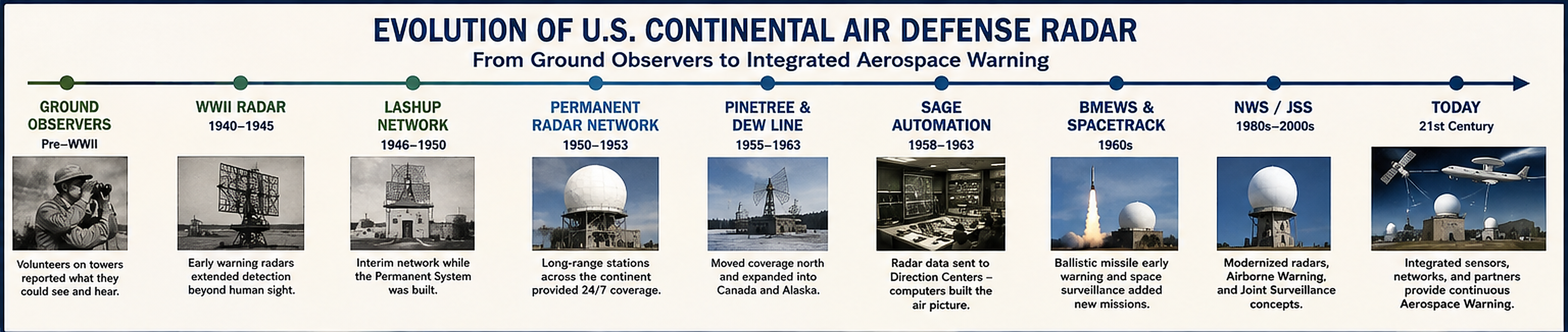
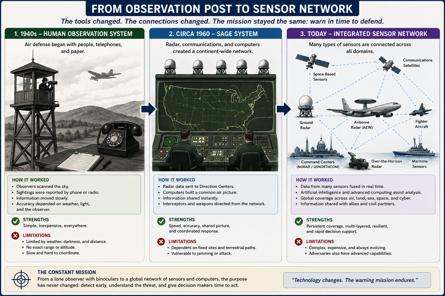
The United States therefore developed an Aircraft Warning Service built around two complementary methods. One was the human observer. Civilian volunteers at observation posts watched the sky with the naked eye or binoculars, identified aircraft as best they could, and telephoned reports to filter centers where tracks were assembled on maps. The other was electronic detection. During the late 1930s the Army tested coastal warning organizations while the Signal Corps developed radar sets capable of detecting aircraft beyond visual range. The Army's official World War II history records Aircraft Warning Service exercises in 1937 and 1938 and notes that the emerging SCR-270 long-range radar caused the War Department in 1940 to revise warning plans around electronic detectors.
Human observation could cover enormous areas cheaply, and during World War II more than a million civilian volunteers participated in the Ground Observer Corps and Aircraft Warning Service. But the method had strict limits. Observers could not see through solid cloud, darkness, haze, or terrain. They could not see far beyond their local horizon. Estimates of altitude, range, and speed were approximate. Reports moved by telephone and had to be filtered manually. A fast aircraft could cross a large distance while a sighting was being identified, reported, plotted, and passed to a fighter unit. Visual observation remained useful, especially for filling gaps, but increasingly fast aircraft made the time problem more severe.
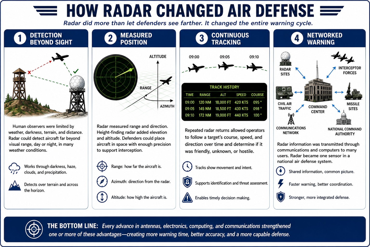
Radar solved several of these problems at once. It could detect an aircraft before the aircraft became visible to a person on the ground, operate at night and through many weather conditions, and provide measured range and azimuth rather than only a visual estimate. When paired with height-finding radar, it could also provide altitude. Most important, radar could produce repeated detections of the same target, allowing operators to construct a track instead of relying on a single sighting. That changed air defense from a chain of eyewitness reports into an electronic surveillance problem.
World War II: Radar Becomes an Operational Warning Tool
American radar development during World War II produced the first generation of systems that made electronic air warning practical on a large scale. The SCR-270 was a mobile long-range early-warning search radar, while the related SCR-271 served fixed-site warning roles. These systems were not modern three-dimensional radars. They primarily established that an aircraft target existed at a measured range and bearing, after which additional observation, plotting, communications, fighter direction, and identification were required. Even so, they represented a decisive change. The defending force no longer had to wait until an aircraft was close enough to be seen or heard.World War II also established the operating pattern that would define postwar air defense. Search radar detected targets. Separate height-finding equipment could refine altitude. Operations personnel plotted tracks. Identification procedures attempted to distinguish friendly from unknown traffic. Ground controllers used radio to direct fighters toward an intercept. Telephone and radio circuits connected radar stations, command posts, fighter bases, antiaircraft units, and civil-defense organizations. The radar was only one part of the system. Its value depended on how quickly and accurately information moved from the antenna to a decision maker and then to a defending weapon.
The wartime United States never experienced the sustained strategic air attack for which the continental warning organization was built, and much of the network was reduced after 1944. That reduction proved temporary. Within a few years, the Soviet Union replaced the Axis powers as the principal air threat, long-range bombers could carry atomic weapons, and the warning time available to continental defenders became strategically important.
The Cold War Rebuild: Interim and Lashup Networks
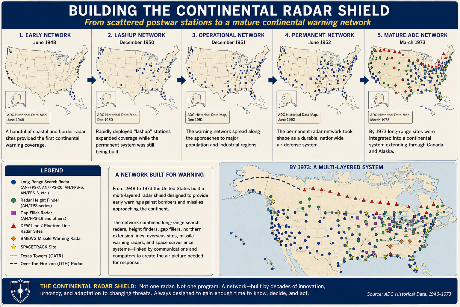
After World War II the United States faced a difficult transition. The wartime network had been demobilized, but a permanent modern radar system did not yet exist. Air Defense Command's own historical data divides the postwar rebuild into an Interim Aircraft Control and Warning System in 1947-1948 and the Lashup Radar Network of 1948-1952. The word "lashup" described the reality. The Air Force had to create useful coverage quickly with equipment and sites that could be made available before the permanent system was ready.The Lashup network used radars such as the AN/TPS-1, AN/CPS-5, AN/CPS-6, and related search and height-finding equipment at temporary or transitional locations. Many of these sites were on existing military reservations, former wartime facilities, or locations chosen for immediate geographic coverage. They were not the final answer. They were an emergency bridge between a dismantled wartime warning structure and the large permanent network then being planned.
At the same time, the Air Force revived the Ground Observer Corps. In 1950 Continental Air Command proposed a new organization of civilian observers to fill the gaps between radar stations. By 1951 hundreds of thousands of volunteers were participating. This second Ground Observer Corps is important because it demonstrates that early Cold War radar was not yet dense enough to provide reliable low-altitude coverage everywhere. Radar and observers operated together because neither alone could yet provide the desired continental picture.
The Permanent Radar Network
Beginning in the early 1950s, the temporary Lashup system gave way to a permanent network of purpose-built radar stations. Air Defense Command's 1973 historical volume tracks this Permanent Radar Network from 1952 through 1963 and shows repeated equipment replacement at individual sites as radar technology improved. Early stations might begin with AN/FPS-3 search radar and AN/FPS-4 or AN/FPS-5 height-finding equipment, then receive AN/FPS-6 height finders, AN/FPS-20-family search radars, AN/FPS-7 stacked-beam systems, or later frequency-diversity radars such as the AN/FPS-24, AN/FPS-26, AN/FPS-27, and AN/FPS-35.The permanent system was built around a fundamental separation of functions. A search radar swept the surrounding airspace and measured range and azimuth. A height finder concentrated on a selected target and measured elevation or altitude. Operators and controllers combined those measurements into a usable three-dimensional track. Later stacked-beam and three-dimensional radars reduced the need for separate height-finding in some applications, but for much of the 1950s and 1960s the familiar radar station had one or more large rotating search antennas plus one or more nodding height-finder antennas.
The network was geographically extensive because radar is constrained by the curvature of the Earth and by terrain. A ground radar cannot see indefinitely over the horizon. Mountains can block low targets, and an aircraft approaching at low altitude may remain below the beam of a distant radar until relatively close to the site. The answer was not simply to build a more powerful transmitter. Air defense required overlapping sites placed so that one station's blind area could be covered by another.
Pinetree, the Northern Approaches, and the DEW Line
The Soviet bomber threat made northern geography central to North American defense. The shortest routes from much of the Soviet Union to major North American targets crossed the Arctic and Canada. That meant a radar screen concentrated only along the U.S. border or coasts would detect an attack too late. Warning had to be pushed northward.The Pinetree radar system extended U.S.-Canadian air surveillance across southern Canada and the northern approaches. Air Defense Command's historical data treats the Radar Extension Program, or Pinetree, as a major phase from 1953 through 1963. Pinetree stations used many of the same search and height-finding radar families found at U.S. permanent sites, but placed them farther north so that hostile bombers could be detected earlier and tracked while interceptors still had time to respond.
The Distant Early Warning Line pushed the idea much farther into the Arctic. By placing radar stations across the far north, the DEW Line sought to detect bomber penetration long before aircraft reached the industrial and population centers of Canada and the United States. The strategic value was time. Every additional minute between detection and arrival gave command centers more time to confirm a track, identify it, alert political and military leaders, launch interceptors, and prepare other defenses.
The northern radar lines also exposed the logistical cost of electronic warning. Remote stations required power plants, communications, airstrips or seasonal resupply, heated buildings, technicians, fuel, spare parts, and continuous maintenance in extreme climates. Radar was not merely an antenna on a hill. A continental warning system was a national infrastructure project.
The Low-Altitude Problem and Gap Fillers
Even an extensive network of long-range radars had a persistent weakness. Low-flying aircraft could exploit the radar horizon and local terrain. As Soviet doctrine and technology made low-altitude penetration more credible, Air Defense Command built a network of short-range gap-filler radars between the principal stations. The AN/FPS-14 and AN/FPS-18 became characteristic systems of this mission, and the AN/FST-1 data-processing and coordinate-transmission equipment helped move reports from remote annexes into the wider network.Gap-filler annexes were deliberately small and often unattended. A typical site consisted of a radar tower and radome, an equipment building, generators, communications lines, fuel and security infrastructure, and an access road. The radar did not need the range of a primary station. Its purpose was to watch a specific piece of low-altitude airspace that a distant long-range radar could not cover reliably.
The gap-filler program helped eliminate one of the Ground Observer Corps' principal Cold War jobs. As electronic low-altitude coverage improved and SAGE automation expanded, the Air Force reduced the Ground Observer Corps to reserve status in 1958 and inactivated it in 1959. The transition is one of the clearest symbols of radar's maturation. A warning function once performed by volunteers scanning the sky with binoculars had become part of an electronic network operating around the clock.
SAGE: The Revolution Was the Network, Not Just the Radar
By the middle 1950s, the air-defense problem had become too large for manual plotting alone. Hundreds of radar stations, civilian aircraft, military flights, interceptor bases, antiaircraft defenses, and potential hostile tracks generated more information than local operators could efficiently combine. Faster jet aircraft also reduced the time available to interpret that information. The solution was the Semi-Automatic Ground Environment, or SAGE.SAGE changed the meaning of a radar station. The radar still detected the target, but the critical output increasingly became data that could be transmitted to a computerized direction center. Equipment such as the AN/FST-1 converted radar information for transmission. At the direction center, the enormous AN/FSQ-7 computer system assembled tracks, supported identification and threat evaluation, and helped controllers direct interceptor aircraft and other weapons. The AN/FSQ-8 served higher-level combat-control functions. Radar was becoming a sensor feeding a command-and-control network rather than a self-contained local warning post.
This was an evolutionary leap in air defense. The problem was no longer merely "Can the radar see the airplane?" It became "Can the entire system detect, identify, correlate, display, decide, and respond before the target reaches its objective?" SAGE linked sensors and weapons across large regions and established the basic architecture that still defines modern integrated air defense: many sensors, a shared operating picture, centralized or distributed decision making, and weapons cued from networked data.
SAGE also drove improvements in reliability and electronic counter-countermeasures. A wartime radar might face accidental interference or weather clutter. A Cold War radar had to assume that a sophisticated enemy would deliberately jam or deceive it. Frequency diversity, improved moving-target indication, better antennas, higher power, receiver modifications, and dedicated ECCM packages such as AN/GPA-102, AN/GPA-103, OA-3424, and OA-4381 reflected the growing contest between surveillance radar and electronic attack.
From Bombers to Ballistic Missiles
The continental radar system of the early Cold War was fundamentally an antibomber defense. Its logic assumed that an attacking aircraft would take time to cross the northern approaches and could potentially be intercepted before reaching its target. Intercontinental ballistic missiles changed that assumption. A ballistic missile traveled vastly faster than a bomber, arrived from extremely high altitude, and compressed warning time from hours toward minutes.The answer was a new class of radar system. The Ballistic Missile Early Warning System, or BMEWS, used powerful long-range radars and precision trackers to detect and characterize missile trajectories. Systems such as the AN/FPS-49 tracking radar and large BMEWS detection radars were not simply improved versions of a GCI search radar. Their purpose was strategic warning. They had to detect objects at enormous distances, determine whether trajectories threatened North America, and feed national command authorities with information reliable enough to support decisions under extreme time pressure.
The missile era expanded the definition of warning. Radar was no longer only supporting an interceptor pilot. It was becoming part of nuclear command and control. A detection could have national strategic consequences, and the system had to distinguish real attacks from technical faults, space objects, and ambiguous tracks.
Space Surveillance: From the Atmosphere to Orbit
The launch of Sputnik in 1957 made another limitation obvious. Air-defense organizations now had to understand not only aircraft and missiles but also man-made objects in orbit. Space surveillance became a related but distinct mission, drawing on radars capable of long-range tracking and on specialized optical systems.Air Defense Command's historical data identifies SPACETRACK beginning in the early 1960s and lists both radar and Baker-Nunn optical camera sites. The Baker-Nunn camera photographed satellites against star fields so that precise orbital information could be calculated from timed photographic plates. Radars such as the AN/FPS-17 and later systems contributed detection and tracking data. The resulting network helped transform the earlier air-defense warning system into an aerospace-defense system concerned with objects above the atmosphere as well as within it.
This evolution continued. Modern space-surveillance radar does not merely wait for a known satellite to pass overhead. The U.S. Space Force's current Space Fence is designed to detect and track objects passing through a broad surveillance volume, including satellites and debris, and feed the space-surveillance network with high-quality orbital data. The mission is very different from watching Soviet bombers, but the underlying principle is familiar: detect objects early, establish accurate tracks, and convert sensor data into a common picture that supports decisions.
Beyond the Radar Horizon
Conventional ground radar is limited by line of sight. Increasing transmitter power cannot make the Earth flat. During the Cold War, engineers pursued systems that could detect activity far beyond the normal radar horizon by using unusual propagation paths. Air Defense Command's 440L system used high-frequency forward-scatter techniques with AN/FRT-80 transmitters and AN/FSQ-76 receivers positioned across widely separated sites. Its purpose was not conventional aircraft tracking. It sought indications associated with missile activity across great distances.Over-the-horizon radar remained attractive because it could provide warning far beyond the range at which an ordinary ground radar would see a low or distant target. The technique is difficult because ionospheric conditions, clutter, propagation variability, and signal processing complicate detection and tracking. Modern computing and digital signal processing have made the concept more useful than it was in the 1960s.
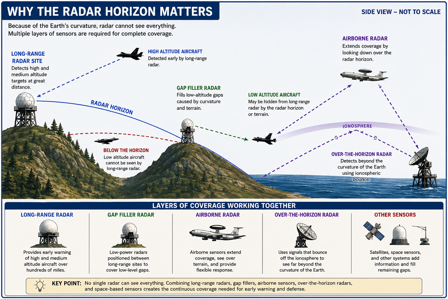
That Cold War idea has returned to the center of continental-defense planning. Canada and the United States are modernizing NORAD surveillance because the existing North Warning System is increasingly challenged by advanced cruise missiles, hypersonic weapons, and other threats that may approach at difficult altitudes and trajectories. In June 2026 Canada formalized a partnership with Australia to acquire Arctic Over-the-Horizon Radar technology, with an initial capability expected by the end of 2029. The broader Northern Approaches Surveillance System is intended to combine over-the-horizon radar, distributed sensors, space-based surveillance, and modern command-and-control systems.
The North Warning System and the Late Cold War
The DEW Line belonged to the 1950s technological world. By the 1980s, its aging equipment and facilities required replacement. The North Warning System, built from the mid-1980s into the early 1990s, replaced much of the old northern line with a smaller number of long-range and short-range radar sites, greater automation, and remote monitoring. Canada describes the system as a chain of long- and short-range air-defense radar sites providing aerospace surveillance of the northern approaches to Canada and the United States.Automation changed the physical character of the northern network. Many sites no longer required the large permanent staffs of earlier Cold War stations. Data could be transmitted to control centers, and maintenance teams could support remote sites without maintaining a full radar squadron at each location. This pattern mirrored changes across the continental system. Radar stations became less like self-contained military communities and more like sensor nodes inside a communications network.
At the same time, military and civil surveillance increasingly shared infrastructure. Federal Aviation Administration long-range radars and Air Force surveillance requirements were integrated through the Joint Surveillance System. This arrangement avoided duplicating a complete national radar grid for civil air traffic and military air defense. In 2021 the Air Force described 149 long-range radar systems used for U.S. air surveillance and defense and jointly for FAA air safety and route control. The network included Common Air Route Surveillance Radars across the interior and ARSR-4 radars around much of the perimeter.
After September 11: The Threat Could Already Be Inside the Radar Screen
The attacks of September 11, 2001 changed the operational meaning of homeland air surveillance. Cold War radar networks had been designed principally to detect aircraft approaching North America from outside. On September 11, the aircraft used as weapons were legitimate domestic airliners already operating inside the continental air-traffic system. That did not make radar obsolete. It changed what the radar picture had to be used for.After 2001, military air defense placed greater emphasis on the continuous national air picture, rapid coordination with the FAA and law-enforcement agencies, and the ability to respond to unknown, unwanted, or unauthorized aircraft already within or near U.S. airspace. The Air Force has stated that the performance of the national long-range radar grid received renewed emphasis after September 11. Civil and military radar data, identification information, command centers, alert fighters, and local defense systems became parts of a homeland-defense architecture that had to look both outward and inward.
The National Capital Region illustrates this layered approach. NORAD describes its integrated air-defense system as combining radars, cameras, a visual warning system, alert aircraft, and Army air-defense assets. The circle from the Ground Observer Corps is not exact, but it is instructive. Modern defense depends overwhelmingly on electronic sensors and data networks, yet visual confirmation and human judgment still complement radar in specialized situations.
The Threat Changed, So the Radar Changed
Air-defense radar did not evolve simply because engineers learned how to build more powerful transmitters or larger antennas. It evolved because the threat kept changing. Each new generation of aircraft, missiles, electronic countermeasures, and operating tactics exposed a weakness in the existing warning system. The response was rarely a single replacement radar. More often it was a new combination of sensors, locations, communications, computers, and operating concepts designed to recover warning time that the changing threat had taken away.The first problem was the bomber itself. In the 1930s and World War II, the central requirement was to detect aircraft before they became visible to observers on the ground. Early warning radars such as the SCR-270 and SCR-271 extended detection beyond human sight and allowed defending forces to begin reacting while an aircraft was still some distance away. Their measurements were limited by later standards, but they solved the first essential problem: an approaching aircraft no longer had to be seen before it could be reported.
The atomic age made warning distance far more important. A single long-range bomber carrying a nuclear weapon could cause damage out of proportion to the size of the attacking force, while faster jet aircraft reduced the time between detection and target arrival. The United States and Canada responded by building the Interim and Lashup networks, then the Permanent Radar Network, Pinetree, and the DEW Line. Radar stations moved north because geography itself became part of the defense. Detecting a bomber hundreds of miles farther from its objective could provide the minutes needed to identify the track, alert command authorities, launch interceptors, and organize a defense.
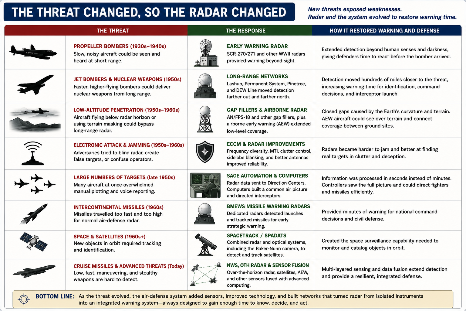
Bombers then changed tactics. A radar designed to watch high- and medium-altitude approaches could be defeated in part by aircraft flying low enough to remain below the radar horizon or hide behind terrain. Air Defense Command answered with gap-filler radars placed between the major stations and, over time, with greater use of airborne surveillance and better low-altitude coverage. This was an important lesson that has never gone away. Radar range printed in a technical manual does not mean that every target can be seen at that distance. Altitude, terrain, antenna height, and the curvature of the Earth determine when a target actually enters the radar's line of sight.
The electronic threat changed the radar itself. A sophisticated enemy could attempt to jam receivers, exploit sidelobes, create false or confusing returns, or use clutter to mask an aircraft. The answer included frequency diversity, moving-target indication, improved antennas and receivers, automatic gain and clutter-control techniques, and dedicated electronic counter-countermeasures. Many of the modification kits and radar variants that appeared during the 1950s and 1960s existed because the radar was no longer competing only with distance and weather. It was competing with an adversary actively trying to make the warning system fail.
Faster aircraft also created an information problem. Even if every radar worked perfectly, hundreds of separate stations and thousands of tracks could overwhelm manual plotting and voice reporting. SAGE addressed that threat to reaction time by converting radar returns into data that could be transmitted to computerized direction centers. The important innovation was not a new beam reaching farther into the sky. It was the ability to combine many radar reports quickly enough to build a regional air picture and direct weapons from it. From that point forward, improvements in computing and communications became as important to air defense as improvements in antennas and transmitters.
Intercontinental ballistic missiles then broke the assumptions of the antibomber system. A missile arrived too quickly and from too high an altitude for the normal chain of ground-controlled interception. BMEWS and related missile-warning radars were therefore built for a different purpose: detect launches or incoming objects at great distance, determine trajectories, and provide strategic warning within minutes. Radar had moved from controlling an air battle to supporting national command decisions in a nuclear crisis.
Sputnik and the growth of military space operations expanded the problem beyond the atmosphere. SPACETRACK combined radar with optical systems such as the Baker-Nunn camera to detect, identify, and maintain tracks on artificial satellites. The sensor mix mattered because no single technology was best for every orbital target or viewing condition. The same principle remains central today. Space surveillance, missile warning, atmospheric surveillance, airborne radar, civil air-traffic radar, and other sensors contribute different pieces of the larger aerospace picture.
Cruise missiles, low-observable aircraft, advanced electronic attack, maneuvering and hypersonic weapons, and other modern threats continue to attack the old limits of warning time and sensor geometry. Some are dangerous because they fly low. Others are dangerous because they move extremely fast, maneuver, approach from less familiar directions, or present difficult radar signatures. Modernization therefore emphasizes layers rather than one perfect radar. Ground-based line-of-sight radar remains essential, but it is increasingly complemented by airborne sensors, space-based surveillance, over-the-horizon radar, distributed sensors, digital processing, and data fusion.
The progression from ground observers to modern integrated aerospace warning can therefore be read as a contest between threat and warning time. Faster aircraft demanded earlier detection. Nuclear weapons demanded wider coverage and greater reliability. Low-altitude penetration demanded gap fillers. Jamming demanded electronic protection. Large numbers of tracks demanded automation. Ballistic missiles demanded strategic early warning. Satellites demanded space surveillance. Cruise missiles and emerging weapons are now driving beyond-the-horizon sensing and multi-sensor fusion. The technology changed because the threat changed, but the purpose remained constant: detect danger early enough to understand it and act before the available time disappears.
Radar Today: A Sensor in an All-Domain Network
In 2026, North American defense no longer depends on a single radar line or a single family of air-defense stations. NORAD's mission is aerospace warning, aerospace control, and maritime warning. Its official description states that the command uses satellites, ground-based radar, airborne radar, and fighter aircraft to detect and respond to air-breathing threats, while other commands and sensor systems contribute missile and space warning.The current architecture includes several overlapping radar missions. The Joint Surveillance System supports national air surveillance as well as civil air traffic control. The North Warning System continues to watch northern approaches while replacement capabilities are developed. Airborne radar extends surveillance beyond the limitations of fixed ground sites. Missile-defense radars such as the Long Range Discrimination Radar at Clear Space Force Station provide precise tracking and discrimination of ballistic-missile threats. Space Fence contributes orbital detection and tracking. Other military, civil, maritime, and space sensors feed the larger command-and-control picture.
Modern radar technology has also changed internally. Mechanical rotation remains useful and widespread, but electronically scanned arrays can steer beams rapidly without physically turning a large antenna. Digital receivers and signal processing can separate targets from clutter more effectively, correlate repeated detections, and support sophisticated electronic protection. Computers can combine data from multiple sensors so that one radar does not have to solve every problem alone. Identification, track correlation, communications, and command-and-control software are now as important to the final air picture as raw transmitter power.
The North Warning System will therefore not simply be exchanged for another row of conventional radar stations. Canada and the United States have stated that future continental surveillance will combine next-generation over-the-horizon radar, distributed sensors, space-based surveillance, improved communications, and modern data fusion. Canada's 2026 Arctic Over-the-Horizon Radar program is one concrete step in that transition. The goal is the same one that drove the first ground observers: see the threat early enough to do something about it. The technology required to achieve that goal has become vastly more complex.
What Changed, and What Did Not
- The history of air-defense radar can be understood as a sequence of attempts to buy time and reduce uncertainty.
- Ground observers answered the question, "Is there an airplane I can see?"
- Early radar answered, "Is there an aircraft beyond visual range, and where is it?"
- Search and height-finding networks answered, "Where is it in three dimensions, and where is it going?"
- SAGE answered, "How do we combine many radar tracks quickly enough to control a continental battle?"
- Gap fillers answered, "How do we stop a low-flying aircraft from hiding under the main radar screen?"
- The DEW Line and Pinetree answered, "How do we move detection farther from the defended target to gain warning time?"
- BMEWS answered, "How do we warn of weapons moving too fast for the antibomber system?"
- SPACETRACK answered, "How do we detect and catalog objects beyond the atmosphere?"
- Over-the-horizon radar answered, "How do we observe activity beyond the geometric horizon?"
Modern integrated surveillance asks a larger question: "How do we fuse every useful sensor into a sufficiently accurate, resilient, and timely picture to detect, identify, track, warn, and respond across air, missile, space, and maritime domains?"
The hardware has changed enormously, but the purpose has remained consistent. Warning is valuable only if it arrives before the threat. Radar became essential because human eyes could not provide reliable, continuous, all-weather, long-range warning against increasingly fast aircraft. It evolved because every improvement in detection created a new operational problem: measuring altitude, covering low-level gaps, resisting jamming, processing more tracks, pushing warning farther north, detecting missiles, tracking satellites, seeing beyond the horizon, and integrating data from many different sensors.
The result is that modern air defense is no longer best represented by a lone radar antenna turning on a hilltop. It is a network. The radar is one sensor among many, connected through computers and communications to command centers, civil aviation systems, satellites, airborne platforms, missile-warning networks, fighters, and defensive weapons. That network is the direct descendant of the observer post, telephone line, plotting table, and early radar station. The tools changed. The mission did not: detect the threat early, understand what it is doing, and give defenders enough time to act.
Radar and Related Equipment Histories
(Click the row for the radar specific page and history)| Radar Equipment | System Family | Equipment Category | In Service Dates |
|---|---|---|---|
| AN/FPS-18 Gap-Filler Search Radar | ADC/NORAD Gap-Filler Network; SAGE | Fixed S-band gap-filler air-search radar | 1958-1970 |
Chronology
- 1910s-1930s Military and civil-defense organizations develop visual aircraft observation, recognition, reporting, and plotting methods.
- 1937-1938 The U.S. Army conducts Aircraft Warning Service exercises while the Signal Corps develops practical aircraft-detection radar.
- 1940 The War Department directs coastal warning planning to incorporate radar detectors such as the SCR-270.
- 1941-1944 Radar stations and a massive civilian Ground Observer Corps operate together in the continental Aircraft Warning Service.
- 1947-1948 Air Defense Command operates an Interim Aircraft Control and Warning System while planning a permanent postwar network.
- 1948-1952 The Lashup Radar Network provides emergency transitional coverage using available search and height-finding equipment.
- 1950 The Air Force revives the Ground Observer Corps to fill gaps between radar stations.
- 1952-1963 The Permanent Radar Network expands and repeatedly modernizes with new search, height-finding, and frequency-diversity radars.
- 1953-1963 The Pinetree radar extension pushes North American warning farther into Canada.
- 1957 The main DEW Line reaches technical readiness, extending warning across the far northern approaches.
- 1957-1970 Gap-filler radars provide low-altitude coverage between long-range stations.
- 1957-1958 NORAD is established as the binational U.S.-Canadian command for North American air defense.
- 1959 The Ground Observer Corps is inactivated as radar coverage and SAGE automation mature.
- Late 1950s-1960s SAGE direction centers integrate radar data through large digital computers and communications networks.
- 1960s BMEWS shifts part of the warning mission from bomber interception to ballistic-missile detection and tracking.
- 1961 onward SPACETRACK and related systems expand the surveillance mission into space, using radar and optical sensors including Baker-Nunn cameras.
- 1968 The 440L forward-scatter system represents an early operational attempt at strategic beyond-the-horizon warning.
- 1970-1972 SLBM warning systems address the growing danger of submarine-launched ballistic missiles approaching from ocean areas.
- 1970s-1980s U.S. military and FAA surveillance increasingly share radar infrastructure through the Joint Surveillance System.
- 1986-1992 The North Warning System replaces much of the older DEW Line architecture with more automated long- and short-range radar sites.
- 2001 The September 11 attacks refocus homeland air defense on threats within the domestic air-traffic system as well as aircraft approaching from outside North America.
- 2020s Modern continental warning combines JSS and North Warning System radars with airborne, missile-warning, space-surveillance, civil, and other sensors.
- 2026-06-22 Canada and Australia formalize acquisition arrangements for a new Arctic Over-the-Horizon Radar capability supporting NORAD modernization, with initial capability expected by the end of 2029.
- Present NORAD continues aerospace warning and aerospace control using a network of satellites, ground-based radar, airborne radar, command-and-control systems, and alert forces while the United States and Canada develop a more layered Northern Approaches Surveillance System.
Sources & References
- WEB U.S. Army Center of Military History, Guarding the United States and Its Outposts, Chapter III, Preparations for Continental Defense Source for prewar Aircraft Warning Service planning and the integration of SCR-270 radar into U.S. coastal warning plans.
- WEB Air & Space Forces Magazine, The Ground Observer Corps, Bruce D. Callander, 2006-02-01 Source for World War II and Cold War Ground Observer Corps organization, scale, purpose, and 1959 inactivation.
- PDF Aerospace Defense Command History Office, Historical Data of the Aerospace Defense Command, 1946-1973 Primary ADC statistical and program source for the Interim AC&W System, Lashup Network, Pinetree, Mobile Radar Program, Gap Filler Program, Permanent Radar Network, DEW Line, BMEWS, SPACETRACK, 440L, and SLBM warning.
- WEB U.S. Air Force Air Combat Command, Searching the Skies: The Legacy of the United States Cold War Defense Radar Program, David F. Winkler, June 1997 Source for the development, operation, architecture, consolidation, and historic legacy of the Cold War U.S. air-defense radar network.
- WEB The Black Vault, Air Defense Command Historical Studies Collection Repository for declassified ADC studies including The Birth of SAGE, Radar Programs for Air Defense, History of the Ground Observer Corps, History of BMEWS, History of the DEW Line, and ADC and Antibomber Defense.
- WEB North American Aerospace Defense Command, NORAD Missions Current official source for NORAD aerospace warning, aerospace control, maritime warning, and the use of satellites, ground-based radar, airborne radar, and fighters.
- WEB U.S. Air Force, 84th RADES Optimizes Nation's LRR Systems for Air Surveillance, National Defense, 2021-09-23 Source for the modern Joint Surveillance System, ARSR-4 and CARSR network, FAA-Air Force cooperation, and the continued homeland-defense role of long-range radar.
- WEB Government of Canada, North Warning System In-Service Support, 2022-01-31 Source for the modern North Warning System, its northern surveillance mission, remote operation, and continued sustainment pending replacement capabilities.
- WEB Government of Canada and U.S. Department of Defense, Joint Statement on NORAD Modernization, 2021-08-14 Source for the binational system-of-systems approach, replacement of the North Warning System, next-generation over-the-horizon radar, and sensor/data integration priorities.
- WEB Government of Canada, Canada-Australia Partnership on Arctic Over-the-Horizon Radar, 2026-06-22 Current source for the Arctic OTHR acquisition program, NORAD modernization role, and anticipated initial capability at the end of 2029.
- WEB United States Space Force, Swinging for the Space Fence, 2020-04-07 Source for the current Space Fence radar concept and its role in detecting and tracking orbital objects.
- WEB U.S. Missile Defense Agency, Long Range Discrimination Radar Source for the current LRDR mission of precision tracking and discrimination of missile threats and integration with the layered U.S. missile-defense system.