
Broughton Island DEW Line Station, Canada
FOX-5 kept watch from a 1,900-foot Baffin Island plateau, where a long road, summer water haul and compact heated compound sustained the radar crew.
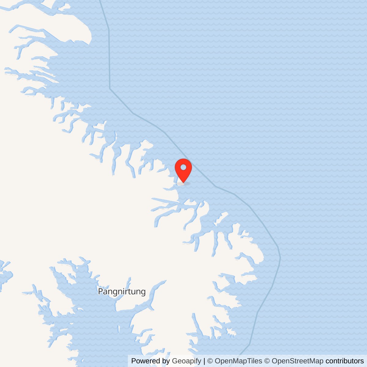
Longitude: -63.787933
Site Number: FOX-5
Current Role: North Warning System short-range radar location, documented in government station inventories.
Broughton Island FOX-5 was a Distant Early Warning Line auxiliary radar station on the eastern edge of Baffin Island. From its high coastal position, the station watched Arctic air approaches and passed reports through the warning network. It lay between Cape Hooper FOX-4 to the west and Cape Dyer DYE-Main to the east. The inhabited community near the island is now called Qikiqtarjuaq. [1] [2] [3] [5]
- DEW Line code
- FOX-5
- Station role
- Auxiliary radar station
- Radar equipment
- AN/FPS-19 and AN/FPS-23
- Communications
- Lattice tower and large reflector antennas
- Original mission
- Arctic aircraft warning
- Later site
- North Warning System short-range radar
- Location
- Eastern Baffin Island, Nunavut
A Radar Watch Above Broughton Island
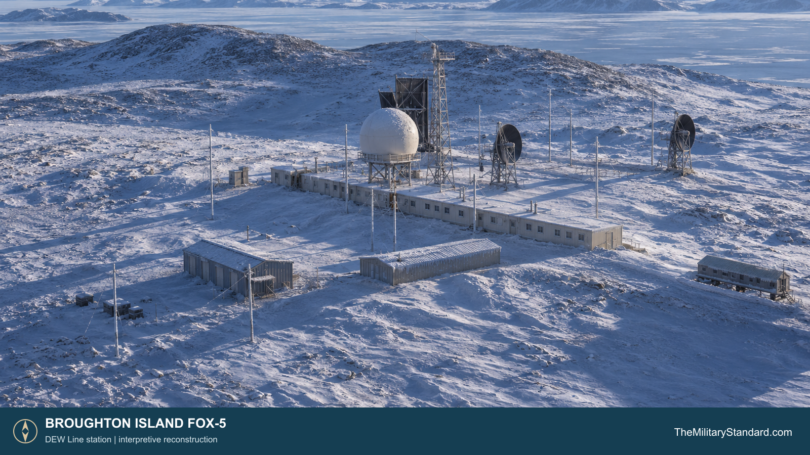
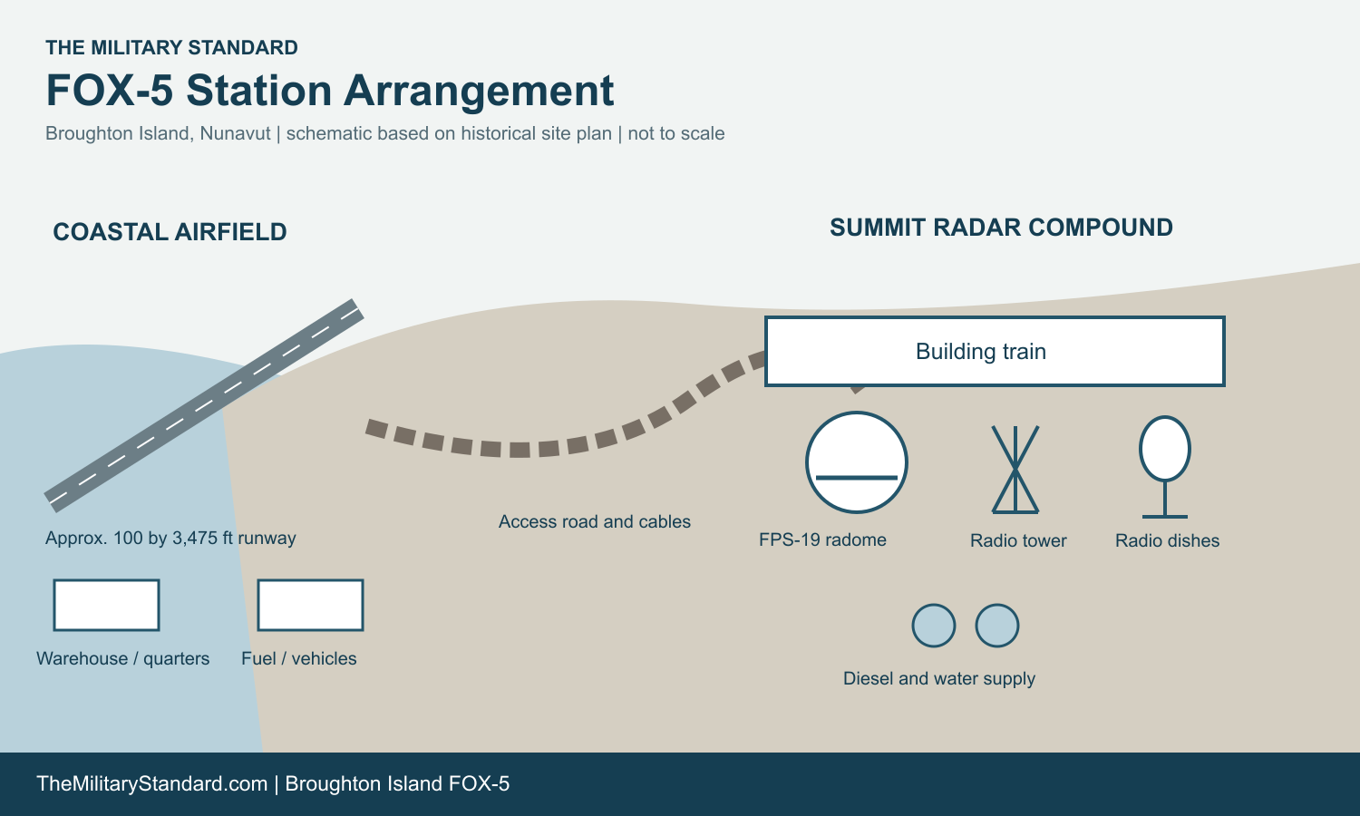
The staffed compound stood on an exposed plateau about 1,900 feet above sea level near the island's southeastern corner. A steep-walled canyon lay immediately south. That elevation gave the radar an open horizon but put the crew, equipment and access road in severe wind and icing conditions. The airstrip and beach supply area were down near the coast, separated from the radar site by a long road. [3] [4]
Building FOX-5
Construction crews developed the airstrip, road and summit station during the mid-1950s DEW Line buildout. Period photographs record snow vehicles on the route in February 1957 and road work in the summer of 1957. On the summit, prefabricated building modules formed a compact train for the radar workplace and living quarters. The elevated search-radar radome and separate radio antennas rose above that low enclosure. [1] [3] [4]
The historical FOX-5 plan places the dormitory, building train, garage and warehouse together at the operating compound. It also marks a vehicle-storage pad, fuel storage, two 65,000-gallon diesel tanks, and a water supply from a stream. Cables and a supply route connected this cluster with the remote airfield. These were practical parts of the defense system: the radar and radios needed steady power, heat, water and replacement parts to maintain the watch. [3] [4]
The airstrip measured approximately 100 by 3,475 feet in the historical plan. Its separate coastal complex included a warehouse, dormitory, heated vehicle storage, aviation fuel and landing aids. Aircraft brought people, mail and urgent parts, while bulk materials moved through the beach and airfield area before traveling up to the station. The distance between runway and plateau made transport a regular operating task. [3] [4]
Radar Equipment and Reporting
Aerospace Defense Command records list August 1957 as the start of manual operation at FOX-5. The station used an AN/FPS-19 search radar and AN/FPS-23 low-altitude gap-filler equipment. The FPS-19 search antenna operated under the raised white radome. The FPS-23 served a separate gap-filling role, helping the line detect aircraft at lower altitude between primary radar coverage areas. [1] [2]
Radar operators watched displays for aircraft returns, while communications workers sent reports along the DEW Line. Radio and electronic technicians maintained the search radar, gap-filler equipment, displays and links. A lattice tower and several large reflector antennas stood beside the building train and carried the station's radio traffic. [1] [2] [3]
FOX-5 was one link in a chain, so the crew had to keep both detection and communications available. The radome sheltered the search antenna from Arctic weather, while the low building train gave technicians access to heated equipment rooms. Generator and maintenance work mattered to the warning mission as directly as radar operation. [1] [3] [4]
Living and Working on the Plateau
Civilian contractor personnel operated and maintained the station for the U.S. Air Force. The isolated crew included the technical and support work needed for continuous operations: radar and radio specialists, power-plant staff, mechanics and people who provided meals and other daily services. The plan's dormitory, garage and warehouse show how closely living space and working space were grouped on the summit. [1] [3] [4]
Water required a special routine. The station history describes a seven-mile round-trip summer haul to fill two electrically heated 65,000-gallon rubber tanks. In winter, an emergency lake about half a mile away could supply water. The two large diesel tanks and fuel-storage areas on the plan supplied the generators and heating plant. Keeping those systems working was essential during long periods when flying and road travel were restricted by weather. [3] [4]
The site account describes heavy snowfall and wide temperature swings, and its 1957 photographs show the access road under snow and ice on the antenna tower. Life at FOX-5 meant maintaining a watch on an exposed hill while coping with uncertain transport, cold machinery and limited contact beyond the station. The connected modules offered shelter, but maintenance still took personnel outside to towers, fuel systems, vehicles and the road. [3] [4]
The North Warning System Era
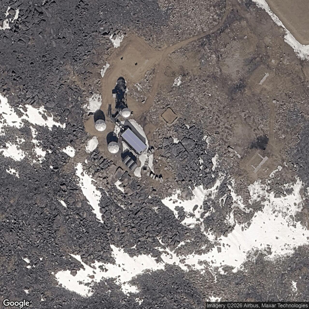
The original staffed DEW Line phase ended during the transition to the North Warning System. The Arctic Institute station inventory records a FOX-5 short-range radar establishment in December 1990 and the end of the original DEW Line operation in 1991. The newer system kept a warning mission at Broughton Island with a different radar and staffing model. [5] [7]
The former DEW Line property was among the sites transferred to Canada between 1989 and 1993. FOX-5 therefore has a distinct history as both a staffed Cold War radar outpost and a later North Warning System location. Its historic plan and photographs preserve the scale of the original station, from the high plateau compound to the distant airstrip and water-haul route. [3] [4] [5] [6] [7]
Chronology
- Mid-1950s Construction develops the airstrip, access road and summit station.
- February 1957 A dated photograph records snow vehicles on the road to FOX-5.
- August 1957 FOX-5 begins manual operation with AN/FPS-19 and AN/FPS-23 equipment.
- December 1990 The North Warning System short-range radar site is established at FOX-5.
- 1991 The original DEW Line operating phase ends.
Information sources (7)
- PDF[1] U.S. Air Defense Command, A History of the DEW Line, 1946-1964
The DEW Line program, construction, operating organization and reporting mission.
- PDF[2] Aerospace Defense Command, Historical Data, 1946-1973, station table
FOX-5 manual operation beginning August 1957 and its AN/FPS-19 and AN/FPS-23 radar equipment.
- WEB[3] The DEWLine, FOX-5 Broughton Island station history and photo gallery
Station setting, construction access, water supply and period views. Privately credited images are research references only.
- WEB[4] The DEWLine, FOX-5 historical site plan
The separation of the summit building train and coastal airstrip, plus water, fuel, road and cable facilities.
- PDF[5] Arctic Institute of North America, The Distant Early Warning Line: A Bibliography and Documentary Resource List
FOX-5 station identity, approximate location and North Warning System transition dates.
- WEB[6] Government of Canada, Exchange of Notes Concerning Environmental Issues, 1996
Identifies FOX-5 among former DEW Line sites returned to Canada between 1989 and 1993.
- PDF[7] Government of Canada, North Warning System site locations
Confirms FOX-5 as a later short-range radar site.