
Ice Cap 2 DYE-3 DEW Line Station, Greenland
A radar watch on the inland ice, sustained by ski aircraft and engineering work, beside a landmark international drilling campaign.
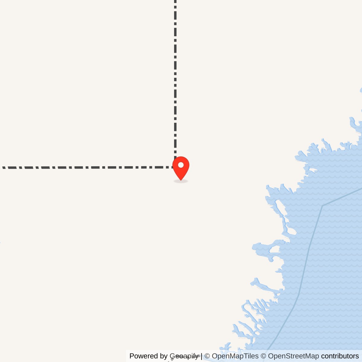
Longitude: -43.81944
Site Number: DYE-3
Current Role: Abandoned former radar building on moving ice; deep ice core and borehole records preserved by research institutions. Present building condition not independently surveyed.
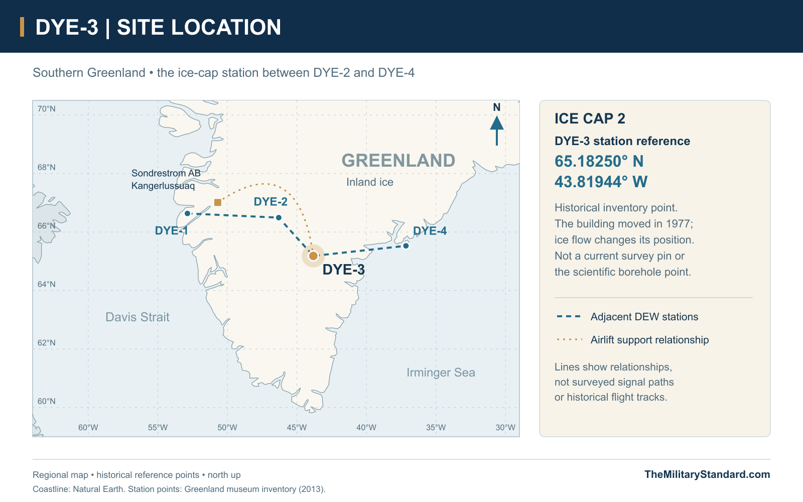
Station reference point 65.1825, -43.81944. View map [6]
- DEW Line code
- DYE-3 / Ice Cap 2
- Role
- Auxiliary radar and communications station
- Radar
- AN/FPS-30 search radar
- Operating period
- August 1, 1961 to the late 1980s; final 109th DEW support flight December 1989
- Scientific drilling
- ISTUK electromechanical ice-core drill, 1979-81
- Recorded site area
- 2,583 acres
- Location
- Southern Greenland inland ice sheet, east of DYE-2
History
DYE-3, or Ice Cap 2, was the eastern of the two Greenland DEW Line stations constructed directly on the inland ice. Its AN/FPS-30 radar and lateral communications helped connect the warning chain between DYE-2 and the coastal station at DYE-4. The Greenland extension entered operational service on August 1, 1961, reporting within the sector centered on Cape Dyer on Baffin Island. [2]
An elevated composite building concentrated the station's technical and living functions above the snow. Repeated lifting and a major relocation kept it usable as snow accumulated and the frozen foundation changed. The same airlift and support infrastructure also made DYE-3 an important base for international ice-core research, while the military watch continued. [5] [12]
Construction on the Ice Sheet
Development of the Greenland ice-cap sites drew on CRREL snow and drifting studies in 1958. Ski-equipped C-130 aircraft became central to the construction airlift in 1959. The aircraft could move personnel, equipment and supplies from Sondrestrom directly onto the ice, avoiding the difficult surface route through the ice-sheet margin. [3]
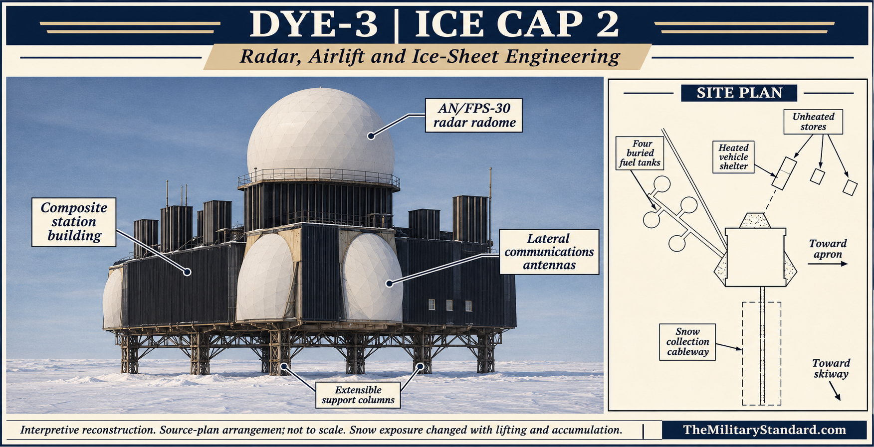
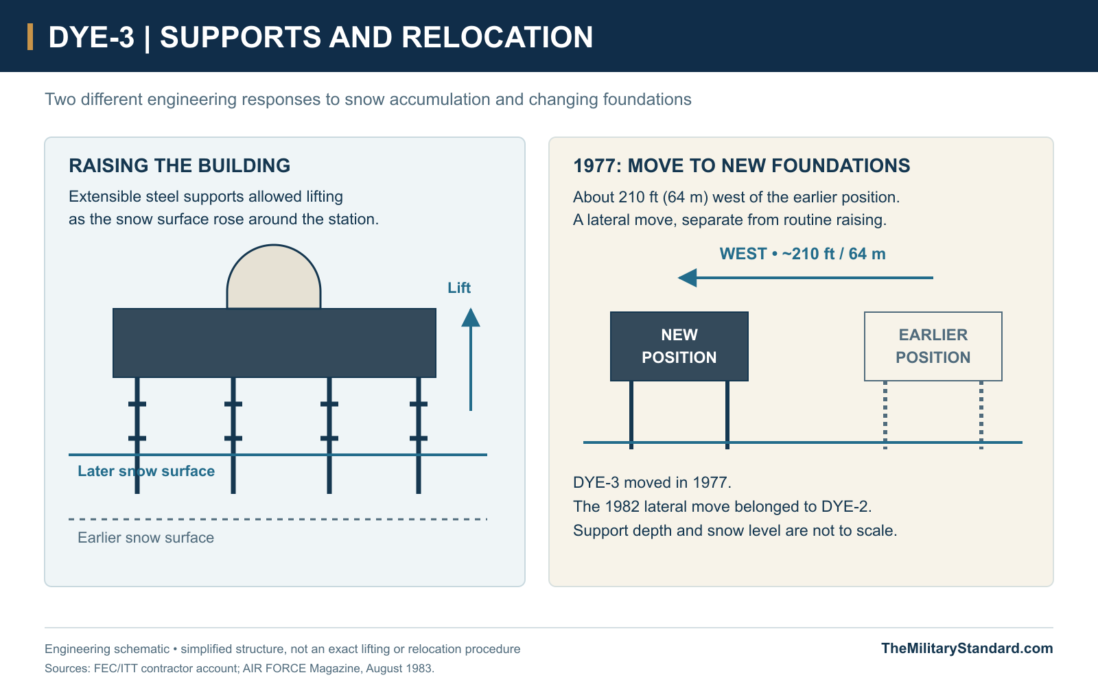
The sister ice-cap stations were built as large steel-supported structures, with columns that could be extended and a building that could be raised. Their footings lay below the snow surface. This approach addressed the accumulation of snow around a continuously occupied station; it also created a support system whose alignment and loading had to be watched throughout its service life. [5]
DYE-3's remoteness affected every stage of construction and operation. The heavy structure and its utilities had to be supplied through the Greenland airlift system, then assembled and maintained in severe cold. The historical station description records a site area of 2,583 acres, a much larger assignment than the visible footprint of the composite building. [1] [3]
Building, Storage and Snow Harvesting
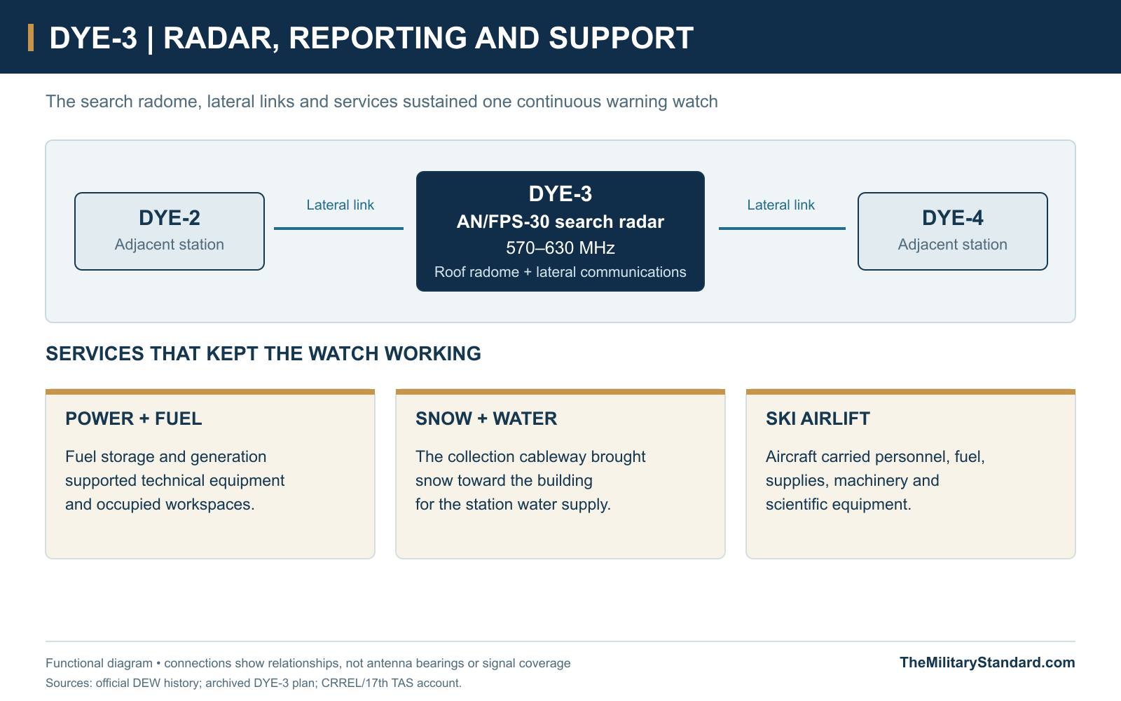
The composite building contained the radar, communications equipment, workspaces and accommodation required by the permanent watch. A large roof radome protected the search antenna, while the side communications enclosures served lateral reporting links. The station's exposed height and the amount of visible support framing changed as the building was raised and snow continued to accumulate. [1] [5]
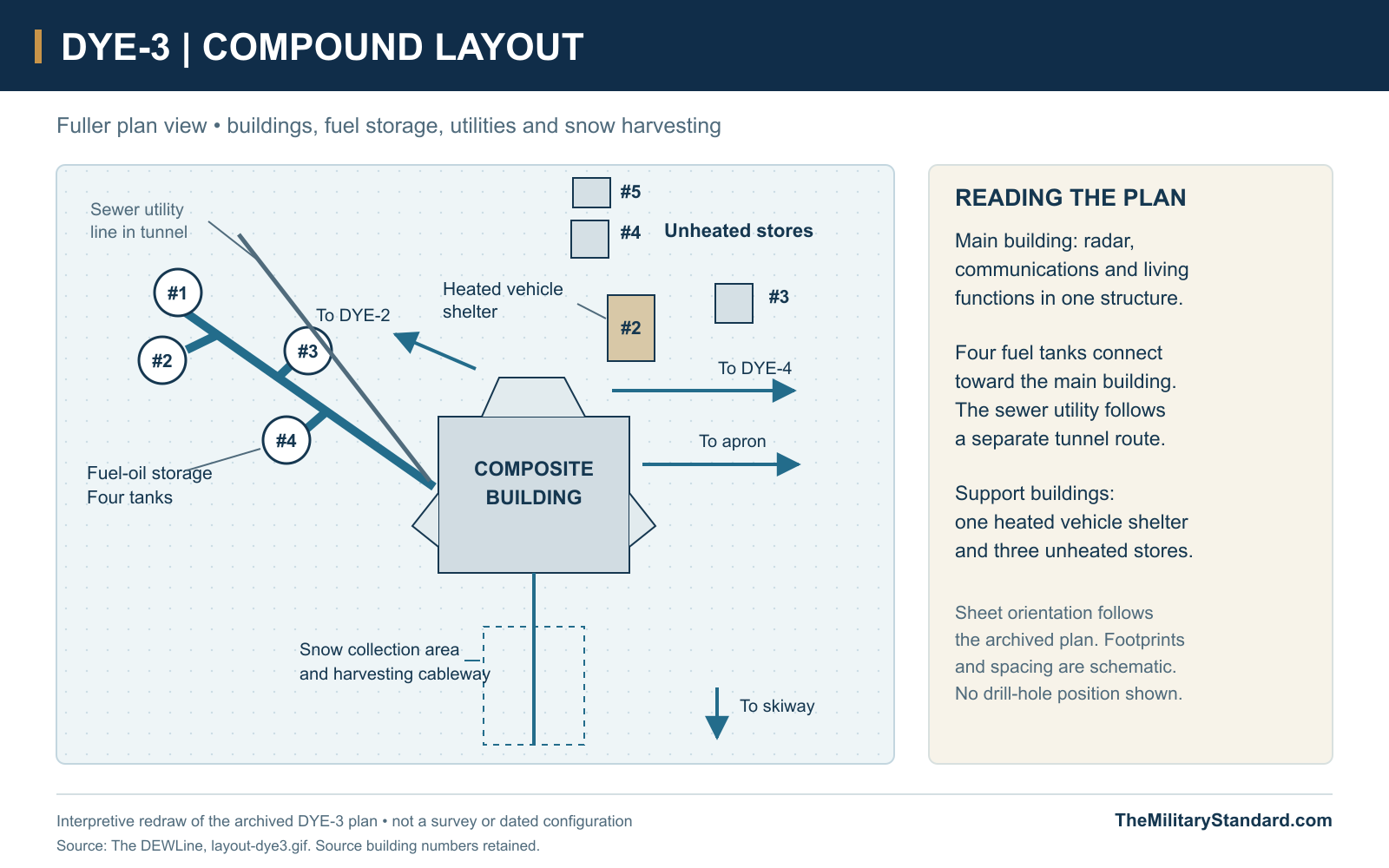
The archived site plan places four fuel-storage tanks to one side of the building, linked by a tunnel arrangement. A separate utility route carried the sewer line. Above the main compound on the drawing are a heated vehicle shelter and three unheated storage buildings. The plan also marks access toward the apron and runway, keeping transport functions distinct from the elevated radar building. [15]
A cableway extended from the building over a snow-collection area. Harvested snow could be melted for the station's water supply, an arrangement shared with DYE-2. The system turned the surrounding snow into a utility resource, while fuel storage, workshops and enclosed connections supported the equipment and occupants through periods when aircraft access was interrupted. [1] [15]
Radar, Communications and the Watch
DYE-3 used the Bendix AN/FPS-30, the search radar installed at the four Greenland stations. It operated in the 570-630 MHz band and combined radar surveillance with identification functions. The official DEW history credits detection ranges up to 200 nautical miles under suitable conditions. These were equipment capabilities, dependent in practice on target and operating conditions. [2]
The site plan identifies lateral communications toward DYE-2 on one side and DYE-4 on the other. The large side enclosures must therefore be distinguished from the rotating search antenna inside the main radome. The warning mission required both a functioning radar and a reliable means of passing its reports along the chain. [15]
Federal Electric operated and maintained the Greenland extension under Air Force contract. Its civilian technicians and operating staff sustained a round-the-clock watch, supported by military command and logistics. American and Danish personnel worked within the wider Greenland DYE system; the small resident community depended on the same building for duty, repairs, meals and off-duty life. [2] [6]
Airlift Support and the 1972 Accident
The 17th Tactical Airlift Squadron supported the Greenland stations and CRREL field parties during the earlier operating period. Its ski-equipped aircraft carried engineers and scientific equipment as well as station supplies. In 1971 it transported drilling personnel and equipment through Sondrestrom to DYE-3 and later carried ice cores out of the site. [3]
On June 5, 1972, C-130D 57-0495 of the 17th Tactical Airlift Squadron crashed near the DYE-3 skiway during a resupply mission. Eight people were aboard. The crew survived, but a Danish passenger died. The aircraft was damaged beyond economical repair, and useful components were salvaged. The loss demonstrated the immediate human risks behind the routine supply of the remote radar watch. [8] [9]
Weather also affected the response. Reproduced Sondrestrom logs record aircraft movements, recovery of the survivors and the dispatch of an investigation team, with poor conditions interrupting access. The wreckage was subsequently dealt with at the site. These accounts document an accident during military support operations, rather than a combat loss. [8]
By 1983, Sondrestrom's 4684th Air Base Group was part of the Greenland DEW logistics structure. The 109th's Raven Gang delivered fuel to DYE-2 and DYE-3 and moved large equipment to the ice-cap stations. Structural work extended the flying season and required loads such as cranes, steel and temporary accommodation. Airlift was essential both to the daily watch and to major construction interventions. [4]
The 1977 Relocation and Continued Maintenance
In 1977 DYE-3 was relocated onto a new set of foundations about 210 feet, roughly 64 metres, west of its earlier position. This was DYE-3's major lateral move; the widely documented 1982 relocation concerned DYE-2. A contractor account states that the sites maintained communications capability through their major alterations. [5]
The move did not end the need to lift and inspect the building. A contemporary 1983 account described the steel already buried beneath DYE-3 before the 1977 operation and reported plans for another lift. Snow accumulation and the behavior of the ice required continuing work on a structure intended to remain staffed and operational in the same environment. [4]
CRREL's survey program examined the composite buildings, fuel systems, waste arrangements and surrounding snow. These repeated visits tied engineering measurements to practical maintenance. An elevated building reduced some drifting problems, but neither its height nor a new foundation made the underlying ice a stationary construction site. [3] [5]
International Ice-Core Drilling
DYE-3 became a major scientific field site while serving as a warning station. An earlier GISP drilling season recovered a 372-metre core in 1971. The larger Greenland Ice Sheet Program joined researchers from Denmark, Switzerland and the United States in investigations of the ice sheet and its climatic record. The existing station and airlift access made DYE-3 a practical place for a deep-drilling campaign. [12] [17]
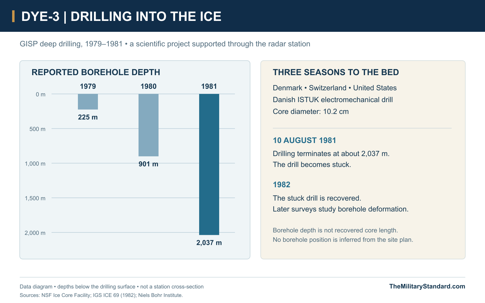
The deep core was drilled during 1979-81 with the Danish ISTUK electromechanical drill. The NSF Ice Core Facility records progress to 225 metres in 1979, 901 metres in 1980 and the bed at approximately 2,037 metres in 1981. The core diameter was 10.2 centimetres. Sections were distributed to research and archive institutions, including Copenhagen and the U.S. ice-core facility. [10]
ISTUK had been designed in Denmark beginning in 1977. Its small size and battery-powered arrangement helped make transport and handling practical, but early drilling encountered serious difficulties. The Copenhagen account describes broken or poorly formed cores, technical changes and a near cancellation before the drill began producing suitable samples. Field teams worked in shifts, and the resulting samples went to laboratories in Copenhagen, Bern and Buffalo. [11]
The drilling terminated on August 10, 1981 at about 2,037 metres when the drill became stuck. It was recovered the following year. Subsequent borehole surveys in 1981, 1983, 1985 and 1986 measured deformation and flow, linking the physical behavior of the ice with the interpretation of the recovered record. These were scientific measurements, separate from the station's aircraft-surveillance radar. [14] [11] [13]
The scientific drilling and the military installation shared logistics without having identical purposes. Warning equipment watched aircraft above the ice sheet; the drilling program investigated the ice below. The convenience of the radar station influenced site selection, while the eventual borehole and laboratory studies extended DYE-3's significance beyond the operating life of the warning network. [17] [13]
ISTUK Equipment and the Drilling Hall
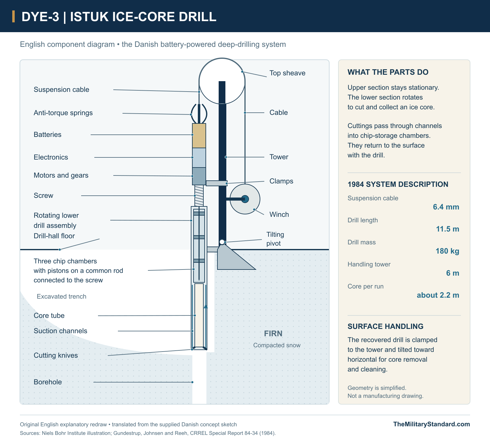
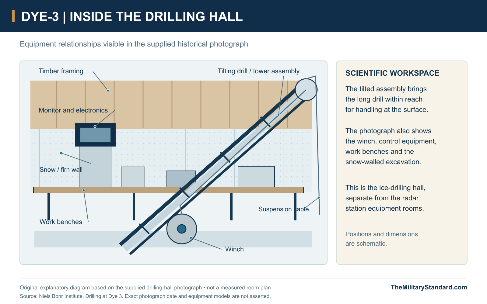
ISTUK combined a stationary upper section with a rotating lower assembly. Anti-torque springs restrained the upper section, which held the batteries, electronics and motors. The lower assembly collected the core and ice cuttings. The 1984 technical description gives a drill length of 11.5 metres, a mass of 180 kilograms and suspension on a 6.4-millimetre cable. [19]
At the surface, the recovered drill was clamped to a six-metre tower and tilted toward horizontal for core removal and cleaning. The drilling-hall photograph shows the long tilted assembly beside work benches, electronic equipment and a winch, within the snow-walled excavation. This was the scientific drilling workspace rather than the radar equipment room. [11] [19]
Withdrawal and the Surviving Station
DYE-3's military role wound down during the final years of Greenland DEW service. The 109th's official history identifies its last flight to radar site DYE-3 in December 1989 as the end of that unit's DEW Line mission. That is a distinct milestone from a radar deactivation order or the last departure of every person associated with the site. [7]
The ice-cap building remained after military withdrawal. Later photographs show the radome and upper structures above deep snow, with much of the former building height obscured. DYE-3 therefore left a different physical legacy from the removed bedrock facilities at DYE-1 and DYE-4. Its changing exposure reflects accumulation and drifting as well as the earlier history of raising and moving the structure. [1] [16]
The ice cores and scientific measurements also survived the station's closure. They remain archived and documented through research institutions. The former radar building, support history and scientific records together preserve several different aspects of a place where Cold War surveillance, polar aviation and international research overlapped. [10] [13]
Chronology
- 1958-60 Development and airlift establish the Greenland ice-cap stations. [3]
- August 1, 1961 The Greenland DEW extension enters operational service. [2]
- 1971 A GISP season recovers a 372-metre core at DYE-3. [12]
- June 5, 1972 C-130D 57-0495 crashes near the skiway; one passenger dies. [8] [9]
- 1977 DYE-3 moves about 210 feet west onto new foundations. [5]
- 1979 Deep drilling reaches 225 metres. [10]
- 1980 The deep borehole reaches 901 metres. [10]
- August 10, 1981 Drilling terminates near bedrock at about 2,037 metres with the drill stuck. [14]
- 1982 The stuck ISTUK drill is recovered. [11]
- 1983-86 Further borehole surveys measure ice deformation and flow. [13]
- December 1989 The 109th flies its final DEW support mission to DYE-3. [7]
- April 2006 Dated photographs document the former station with extensive snow burial. [1]
Related Sites
Information sources (19)
- WEBThe DEWLine, Site: DYE-3, historical description and photographs
Station identity, historical area, relationship to DYE-2 and operating/abandoned photographs.
- WEBThomas W. Ray, A History of the DEW Line 1946-1964, ADC Historical Study No. 31, June 1965
Greenland extension, AN/FPS-30 radar, Federal Electric operation and August 1, 1961 activation.
- WEBSteven J. Mock, Greenland Operations of the 17th Tactical Airlift Squadron and CRREL, March 1973
Construction airlift, engineering surveys and 1971 scientific drilling support at DYE-3.
- PDFAIR FORCE Magazine, August 1983, page 71
DYE-3 relocation in 1977, further lifting plans and 109th ski-aircraft logistics through Sondrestrom.
- WEBFEC/ITT, On the Ice Caps of Greenland, archived contractor newspaper
DYE-3 relocation about 210 feet west in 1977, extensible columns and continued communications during alterations.
- PDFJens Fog Jensen, Inge Bisgaard and Jens Heinrich, Anlaeg fra Den Kolde Krig i Groenland, Field Report 34, 2013
Danish/Greenlandic heritage account of staff, ice-cap facilities and DYE-3 inventory coordinate.
- WEB109th Airlift Wing, History
Official identification of the last DEW mission flight to DYE-3 in December 1989.
- WEBCaptain Michael F. Monaghan, Last Picture of a Ski-Bird, AAHS Journal, Spring 1974, with reproduced Sondrestrom logs
C-130D 57-0495 loss at DYE-3 on June 5, 1972 and subsequent recovery/investigation activity.
- WEBContemporary accident clipping, June 1972, preserved by the Firebirds archive
17th Tactical Airlift Squadron identification, eight occupants and one fatality in the DYE-3 accident.
- WEBNSF Ice Core Facility, Dye-3 core inventory
GISP partners, ISTUK drill, 1979-81 depths, core diameter and archive locations.
- WEBNiels Bohr Institute, University of Copenhagen, Drilling at Dye 3, September 12, 2014
Danish drill development, field logistics, early difficulties, sample processing and recovery of the stuck drill.
- WEBC. C. Langway, H. Oeschger and W. Dansgaard, The Greenland Ice Sheet Program in Perspective, 1985
The 1971 intermediate core, GISP program and August 10, 1981 bedrock milestone.
- WEBB. Lyle Hansen and N. S. Gundestrup, Resurvey of Bore Hole at Dye 3, South Greenland, Journal of Glaciology 34(117), 1988
1981, 1983, 1985 and 1986 borehole surveys and measured ice-flow characteristics.
- PDFInternational Glaciological Society, ICE 69, second issue 1982, Recovery of the GISP Drill at Dye 3
Contemporary account of the August 10, 1981 drilling termination and stuck drill.
- WEBThe DEWLine, archived DYE-3 site plan
Composite building, lateral connections, four fuel tanks, utility tunnel, stores, vehicle shelter and snow-harvesting area.
- WEBDanish Agency for Culture and Palaces, 3. Dye radarstationer, July 24, 2019
Greenland station network, reported 1988 closure and surviving ice-cap structures.
- PDFC. C. Langway, The History of Early Polar Ice Cores, Cold Regions Science and Technology 52, 2008
Scientific site-selection constraints, preparatory thermal drilling and Danish ISTUK work to bedrock.
- WEBNatural Earth, 1:50 million Admin 0 countries, vector dataset
Public-domain coastline geometry for the regional location diagram; station and base points follow the Greenland museum inventory.
- PDFNiels S. Gundestrup, Sigfus J. Johnsen and Niels Reeh, ISTUK: A Deep Ice Core Drill System, CRREL Special Report 84-34, 1984, pages 7-19
Original technical description of the DYE-3 probe, anti-torque arrangement, cable, rechargeable power, dimensions and tilting-tower handling.