
Beaver Creek Radio Relay Station, Alaska
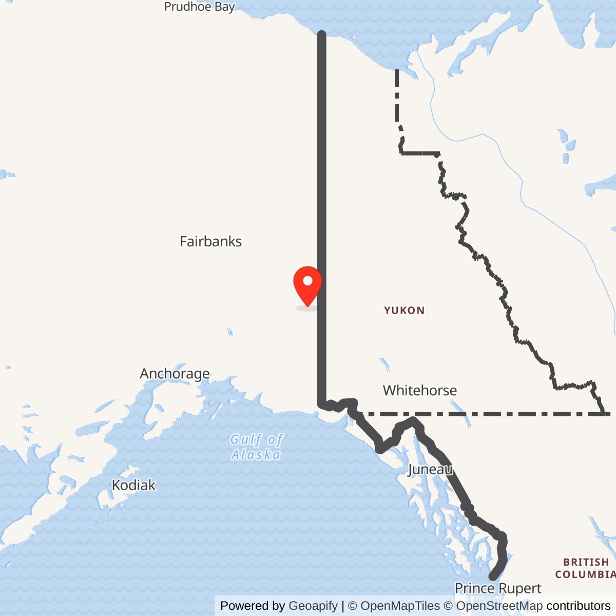
Longitude: -141.828322
Coordinate note: 63.058843 N, 141.828322 W is Alaska DEC's WGS84 environmental-site marker for OT001. It is not a surveyed tower point, installation centroid or boundary.
- Role
- White Alice B-route TD-2 microwave relay for BMEWS rearward communications.
- Service
- Constructed in 1960; original Air Force relay role ended around 1975. Later commercial communications use is documented through 2015.
- Direct links
- Tok Junction, Alaska, and Mount Dave, Canada.
- Site area
- The documented 2.5 acres are the OT001 relay tract, not a verified entire-station acreage.
- Cleanup
- OT001 designated Cleanup Complete in 2015 without active institutional controls; other former station areas are not covered by that determination.
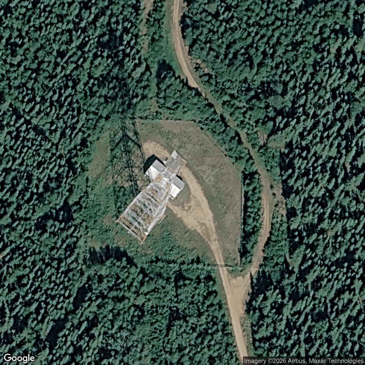
Beaver Creek Radio Relay Station was an Air Force microwave relay near Mile 1267 of the Alaska Highway, about three miles northwest of Northway Junction. It was part of the inland, or B, route of the White Alice rearward communications system built to carry Ballistic Missile Early Warning System traffic toward Canada and North American command centers. The station should not be confused with the community of Beaver Creek in Yukon Territory or with the larger Beaver Creek Research Site around it. Its military relay function was established in 1960 and ended around 1975, but the communications property remained in later commercial use. A 2015 Air Force report still described a building and antenna tower leased to AT&T. That is the latest site-specific physical-use evidence reviewed here, not proof of their condition in 2026. [1] [2] [3]
Origins and route purpose
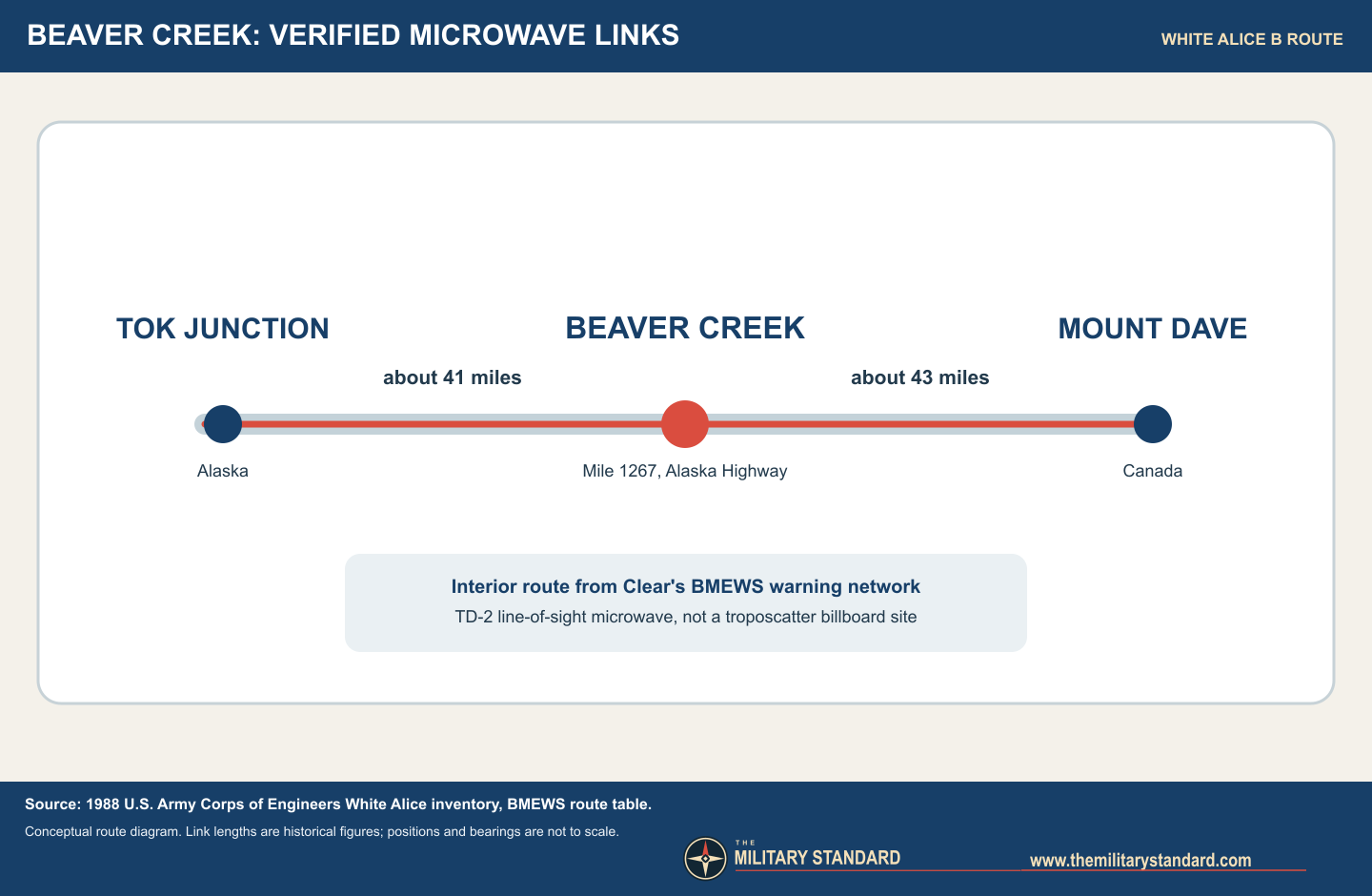
Alaska's first White Alice network served an aircraft-warning geography in which great distances, mountains and high-latitude propagation made older high-frequency radio unreliable. The BMEWS expansion faced a related but more time-critical problem: an early warning from Clear Air Force Station had to reach continental command authorities by more than one path. The Army Corps of Engineers' historical inventory distinguishes a coastal A route from an interior B route. Beaver Creek stood near the eastern end of the B route, where a microwave hop from Tok Junction crossed toward Mount Dave in Canada. The Corps gives the two Beaver Creek links as approximately 41 and 43 miles, respectively. These are historical route distances, not modern property-to-property GIS measurements. [1] [2]
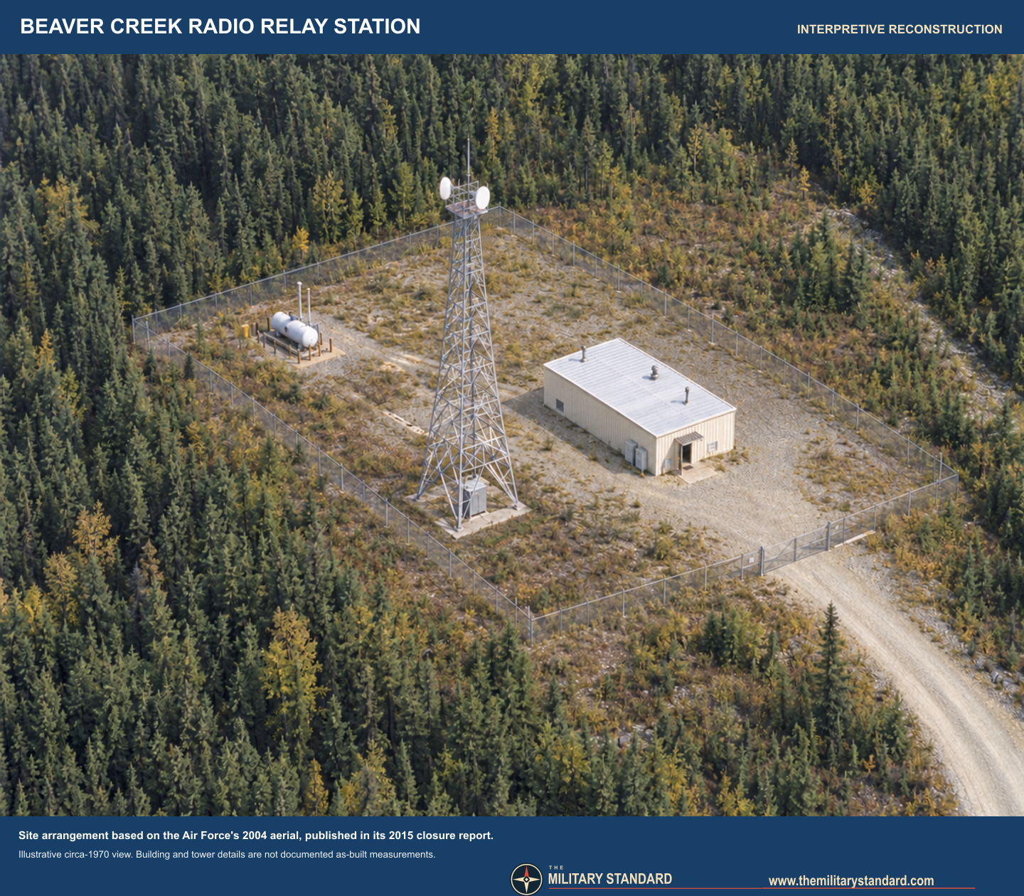
The distinction between microwave and tropospheric-scatter technology matters here. Much of White Alice is remembered for enormous billboard reflectors, but the Corps describes the BMEWS route stations as TD-2 line-of-sight microwave installations. Its standard arrangement was a radio relay building, a petroleum tank and a TD-2 tower; some stations also had latrines or vehicle facilities. Beaver Creek's 2015 closure report independently identifies a one-story steel-frame relay building, antenna tower, latrine, underground tank, parking and waste areas. The surviving evidence supports the TD-2 route role and this general physical plant. It does not establish a station-specific transmitter serial number, tower height, antenna model or complete circuit assignment, and those details should not be borrowed from another relay site. [1] [3] [4]
Construction, setting and facilities
The Corps places the BMEWS microwave construction program in 1960, with stations opening in 1960 or 1961. Alaska DEC and the Air Force's later site report give 1960 for Beaver Creek's construction. An exact first-operational day has not been found. The 1967 USAF installation directory independently lists Beaver Creek Radio Relay Site, confirming that it was a recognized Air Force property during its operating period. The first verifiable task was the B-route relay itself; the reviewed documents do not establish a permanently assigned military squadron or resident crew at Beaver Creek. Later records call it an unattended microwave facility, consistent with maintenance visits rather than a large cantonment. [1] [3] [4] [5]
The relay sat north of the Alaska Highway within the broader Defense Department Beaver Creek Research Site. The 2015 Air Force map identifies a short access road from Mile 1267 and locates the radio compound well away from Northway Junction, the Tetlin National Wildlife Refuge and the Canadian border. Its detailed site figure shows a fenced parcel containing the relay building, central tower base, tank area and a small biopile area, with a drainage ditch running past the northwest edge. This arrangement explains why a fuel release was later followed both inside the compound and beyond its fence. Alaska DEC's published 63.058843 N, 141.828322 W coordinate is a WGS84 environmental-site marker for OT001, not a surveyed tower location, installation centroid or property boundary. The map is a historical environmental-plan view, not a surveyed plan of all former Air Force interests. [2] [3]
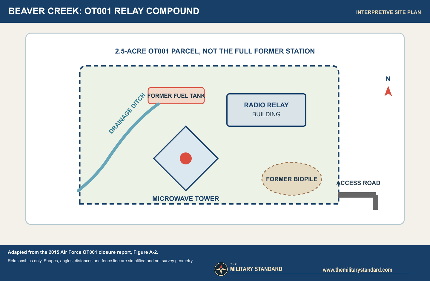
There are several land areas that must not be collapsed into a single acreage. The 1988 Public Land Order withdrew about 2.5 acres for the Air Force radio relay site. The 2015 cleanup investigation also treats OT001 as a 2.5-acre parcel, and DEC explicitly warned that OT001 was only one part of the larger Beaver Creek Radio Relay Station, which could include former disposal areas along a road and another structure north of the parcel. A 1979 federal land notice describes road, cable and utility easements reaching the relay and a nearby AFTAC facility. Those linear interests and the wider research property are not included in a verified station-wide acreage total. [3] [6] [7]
Operations and connections
The relay's immediate military network neighbors were Tok Junction to the west and Mount Dave in Canada to the east. Tok Junction in turn linked to Cathedral, continuing the inland line back toward other Alaska nodes and Clear. The Corps' route table makes Beaver Creek a line-of-sight relay in a chain, not a radar station: it received communications traffic, regenerated or passed it onward, and depended on the adjacent stations for continuity. The Canadian endpoint is a network connection, not evidence that the Canadian facility was an American installation. The inland path supplied redundancy alongside the coastal route; a failure, weather event or attack on one route need not sever every command circuit from Alaska. [1] [2]
The 1979 land notice adds physical context to this apparently simple diagram. It reserved road access from the highway, an existing cable from an Alaska Communications System pole line and an easement for a road and utility connection toward an AFTAC site. These show that the relay operated within a local web of communications, power and access interests beyond its fenced tower compound. The notice does not establish whether AFTAC was a distinct installation or a component of the larger Defense Department research property. A 1976 Federal Communications Commission notice separately records RCA Alascom activity on the Tok Junction to Beaver Creek path. It documents continued route use in a commercial licensing context, but a construction-permit notice should not be mistaken for proof that every proposed frequency was ultimately placed in service. [7] [8]
Role in the Wider Military Network
Beaver Creek was the Alaska-to-Canada exit of the BMEWS interior route. Clear's long-range warning value depended not just on its radar, but on a chain capable of delivering a warning quickly and reliably to continental command authorities. Tok Junction, Beaver Creek and Mount Dave were successive communications nodes in that chain. The station's strategic significance therefore lay in transport and redundancy, not in local detection or weapons control. Its modest building and tower served a larger defense system whose operational geography extended far beyond the 2.5-acre relay tract. [1] [2] [3]
Transition and later telecommunications use
DEC's site record says the original Air Force operation lasted until approximately 1975. That date should not be read as abandonment of the facility. The Corps' 1994 cultural-resources plan described Beaver Creek as an unattended Alascom microwave facility leased from the Air Force, and the Air Force's 2015 closure report dates the start of an Alaska Communications Inc. lease to 1984. The 1988 land withdrawal protected the Air Force relay parcel for 20 years; a 2008 federal order extended that protection through May 22, 2028. These legal and commercial milestones are compatible with military mission termination around 1975 and later reuse, but they do not supply an exact Air Force shutdown date or present-day operator confirmation. [3] [4] [6] [9]
The 2015 Air Force report says AT&T had acquired the Alascom operation and leased the building and tower, which its personnel visited occasionally for antenna, storage, power and electronic maintenance. It says no building demolition had been documented at that point, apart from tank removal and related excavation. A separate cultural survey described the relay as repurposed, while DEC's cleanup status concerned the contaminant area rather than declaring the installation closed. [2] [3] [4]
Environmental history and limits of closure
The fuel system drove most of the documented restoration work. In 1990 the lessee removed a leaking 20,000-gallon underground storage tank and about 450 cubic yards of petroleum-affected soil, storing excavated material in a biopile southeast of the microwave tower. A 1992 Air Force visit found the biopile deteriorating and a petroleum-affected ditch extending toward and beyond the fence. The biopile soil was landspread under state approval in 1992. In 1993 another 57 cubic yards of ditch soil was taken to Fairbanks for incineration. Alaska DEC concurred in a no-further-action proposal in December 1994, but later sampling and agency review showed that the early decision did not end the inquiry. [3] [10]
The Air Force's 2000 investigation found diesel-range organics above the then most stringent migration-to-groundwater screening level at some biopile and building-entry samples. DEC requested further work in 2002, including attention to pipelines, drains, septic and waste areas. In 2014 investigators took 26 surface and 24 subsurface soil samples and inspected six formerly cleared areas beside the access right-of-way for possible burial. The report found no observed buried debris there. Diesel- and residual-range organics above the most stringent screening numbers were confined to ditch samples. Bedrock was often encountered at about four feet, and no groundwater was encountered during drilling, so the agency used applicable ingestion criteria rather than assuming a groundwater-exposure route at OT001. The final report identifies one residual-range organics result above the ingestion level; deeper samples within ten feet were nondetect for extractable petroleum hydrocarbons, and DEC accepted the remaining affected volume as de minimis. DEC's online site summary instead calls the isolated exceedance diesel-range organics. The history follows the final analytical report for the analyte while disclosing that discrepancy. [2] [3] [10]
On September 17, 2015, Alaska DEC accepted the final report and designated OT001 Cleanup Complete without active institutional controls. The agency's letter retained standard conditions for offsite movement of affected soil or groundwater and prohibited use or movement of contaminated material that would violate water-quality standards. The decision allows reassessment if new evidence changes the risk picture. Most importantly, it resolves the defined OT001 environmental site, not every possible historical use area within Beaver Creek RRS or the surrounding Defense Department research site. The absence of an OT001 land-use control is not a claim that the entire former station was surveyed, conveyed or made available for unrestricted redevelopment. [2] [3] [10]
Historic evidence and present interpretation
Beaver Creek's record is particularly useful because it separates four timelines often conflated in former military sites: construction in 1960, ending of the original military relay role around 1975, commercial reuse documented from 1984 through at least 2015, and cleanup of one defined parcel in 2015. The exact military closure order, local handover agreement, complete property boundary, full station equipment list and present condition remain unverified. The sources nevertheless establish a distinctive inland BMEWS relay and explain why its small microwave compound mattered to a continental warning network. [1] [3] [4] [6] [10]
Chronology
- 1960 The Air Force constructed Beaver Creek's TD-2-era microwave relay as part of the BMEWS rearward communications expansion. [1] [3]
- 1960-1961 The Corps dates the BMEWS route stations' openings to this period; Beaver Creek's exact day is unverified. [1]
- 1967-09-15 A USAF installation directory listed Beaver Creek Radio Relay Site. [5]
- circa 1975 Alaska DEC's historical summary places the end of original Air Force operation around this year. [2]
- 1976-12 An FCC notice recorded RCA Alascom's proposed Tok Junction to Beaver Creek microwave path. [8]
- 1979-08-21 A federal land notice described access, cable and utility easements serving the relay and nearby AFTAC site. [7]
- 1984 The Air Force report dates the start of Alaska Communications Inc.'s lease of the relay property. [3]
- 1988-05-23 Public Land Order 6677 withdrew a 2.5-acre Air Force relay tract for 20 years. [6]
- 1990 The lessee removed a 20,000-gallon fuel tank and roughly 450 cubic yards of affected soil. [3]
- 1992 Investigators found petroleum effects in a ditch and the former tank-soil biopile was landspread under state approval. [3]
- 1993-06 Fifty-seven cubic yards of affected ditch soil were removed for incineration in Fairbanks. [3]
- 1994-12 Alaska DEC concurred in an initial no-further-action request after those removals. [3]
- 2000 New surface sampling found diesel-range organics above the most stringent preliminary screening level. [3]
- 2002 Alaska DEC requested additional evaluation of possible fuel and waste source areas. [3]
- 2008-05-23 Public Land Order 7699 extended protection of the 2.5-acre tract through May 22, 2028. [9]
- 2014 A remedial investigation sampled soil and inspected six cleared areas along the right-of-way. [3]
- 2015-09-17 Alaska DEC designated OT001 Cleanup Complete, with no active institutional controls and standard soil-movement conditions. [2] [10]
Information sources (11)
- PDF[1] Georgeanne Lewis Reynolds, Historical Overview and Inventory: White Alice Communications System, U.S. Army Corps of Engineers, April 1988
Source for: BMEWS A and B route purposes, TD-2 station design, 1960-1961 program timing and Beaver Creek's Tok and Mount Dave links and distances.
- WEB[2] Alaska Department of Environmental Conservation, Site Report: Beaver Creek RRS Repeater Site, hazard ID 1703
Source for: construction and approximate military operating period, later site description, DEC WGS84 environmental locator and OT001 status chronology.
- PDF[3] Pacific Air Forces Regional Support Center and Air Force Civil Engineer Center, Site Closure Report: White Alice Communications System Site OT001, Beaver Creek RRS, September 2015
Source for: parcel and facility layout, Air Force and AT&T lease history, fuel removal, soil investigations, actual site maps and scope-limited closure findings.
- PDF[4] D. Colt Denfeld, The Cold War in Alaska: A Management Plan for Cultural Resources, U.S. Army Corps of Engineers, August 1994
Source for: Beaver Creek's then-active unattended Alascom use and cultural-resource context for similar microwave stations.
- PDF[5] U.S. Air Force, USAF Installation Directory, September 15, 1967
Source for: contemporary official listing of Beaver Creek Radio Relay Site as an Air Force installation.
- PDF[6] U.S. Department of the Interior, Public Land Order 6677, Federal Register, May 23, 1988
Source for: legal description and 2.5-acre land withdrawal to protect the Air Force radio relay tract.
- PDF[7] U.S. Department of the Interior, Alaska land easements notice, Federal Register, August 21, 1979
Source for: road, cable and utility easements between the highway, relay and neighboring AFTAC facility, without proving a separate installation identity.
- PDF[8] Federal Communications Commission, RCA Alascom microwave applications notice, Federal Register, December 1976
Source for: contemporary commercial licensing activity on the Tok Junction to Beaver Creek microwave path; applications are not asserted as final operating authorizations.
- PDF[9] U.S. Department of the Interior, Public Land Order 7699, Federal Register, April 15, 2008
Source for: extension of the 2.5-acre withdrawal through May 22, 2028.
- PDF[10] Alaska Department of Environmental Conservation, Beaver Creek OT001 Closure Letter, September 17, 2015
Source for: formal Cleanup Complete decision, its standard conditions and reservation of future agency action.
- WEB[11] Library of Congress, Historic American Engineering Record AK-23-A, Rabbit Creek White Alice Site, radio relay station photographs
Source for: separately identified representative TD-2 microwave building and tower photographs, and the Library's rights advisory; these are not images of Beaver Creek.