
Lost Hills Auxiliary Field No. 7 / Lost Hills Airport, Lost Hills California
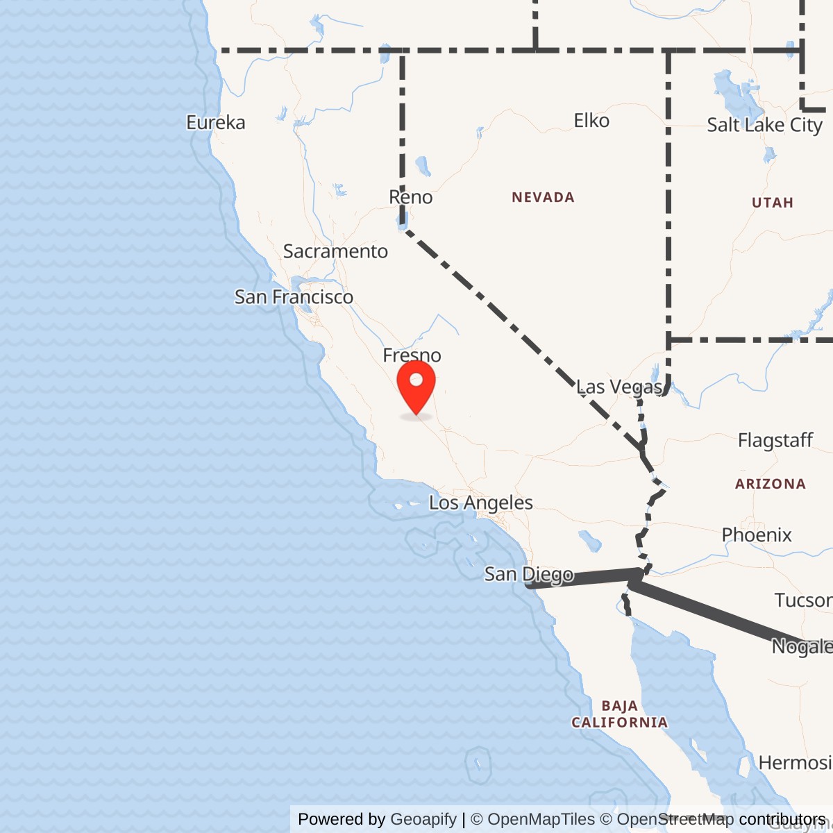
Longitude: -119.6805560
Official Base Website: Former Lost Hills Airport site
Current Role: Closed former airport property in mixed industrial, public, agricultural, and redevelopment reuse; surviving civil-runway pavement is marked closed. Exact 2026 parcel ownership was not established.
Lost Hills Auxiliary Field No. 7 was a wartime Army Air Forces satellite of Minter Field built from an existing Kern County civil landing field rather than created on undeveloped ground. The installation lay in the western San Joaquin Valley, in open country dominated by agriculture and petroleum development. Its military value came from uncomplicated approaches, dry terrain, distance from dense settlement, and enough land to build a long paved runway, a secondary landing strip, and protected aircraft parking. It had almost none of the buildings associated with a self-contained Army air base.
The field is best identified through several names that describe different phases of the same place. Before federal acquisition it was Lost Hills Airport, a small county-leased public aviation field. During Army use it appeared as Lost Hills Auxiliary Field, Lost Hills Field No. 7, Minter Field Auxiliary No. 7, and in period directories as Lost Hills Kern County Airport. After federal disposal it again became a county airport, later carrying the identifier L84. The military and civilian phases share the same general airfield landscape, but their acreage and runway configurations should not be treated as identical.
The War Department's legal estate totaled 448.26 acres. That estate figure comes from the property-acquisition record and is the best value for military acreage. The January 1945 AAF directory, by contrast, listed 240 acres as the airfield's total area. The difference is not evidence that one source must be wrong. The directory was describing the usable operational airfield, while the real-property history was accounting for the full federally acquired estate, including land beyond the immediate landing surfaces and aircraft movement area.
Lost Hills was not a separate flying school, troop cantonment, depot, bombing range, or gunnery installation. No evidence found identifies a permanently stationed Lost Hills squadron or a separate post commander. It functioned as an outlying airfield whose users came from parent or nearby training bases. That distinction matters because the installation's importance was operational rather than organizational. Its value lay in absorbing training traffic away from Minter's main runway system and providing a long, uncomplicated auxiliary landing facility within the larger Central Valley flying-training network.
Prewar Civil Airport and Army Acquisition
The military field inherited an aviation history that began before the Army arrived. Lost Hills was not shown on a 1933 USGS aerial photograph, but it appeared on the December 1935 Los Angeles Sectional Chart. The 1936 Department of Commerce Airway Bulletin No. 2 described two packed-sand runways in an L-shaped arrangement, a 2,200-foot north-south strip and a 1,600-foot east-west strip. The modest field therefore existed as a rural public landing place several years before wartime training requirements transformed it.
Kern County did not own the entire prewar airfield outright. The later War Department property history states that the land had been leased by Kern County for public aviation use. That arrangement explains how the Army could inherit a functioning airport yet still have to acquire private property. On 1942-11-05 the War Department purchased 160 acres in fee from Jean Atkinson. This is the first securely documented federal acquisition date, although it should not be confused with the earlier civil airport's opening.
The Army enlarged the property on 1943-08-30 by purchasing another 288.26 acres from Standard Oil Company of California. The two fee acquisitions produced the documented 448.26-acre wartime estate. This second purchase was not a minor boundary adjustment. It gave the government a substantially larger tract on which to support the paved runway, taxiway, revetted parking, drainage, and safety clearances needed for military use. The sequence also reflects the rapid wartime practice of improving a field while real-estate actions were still being completed.
The surviving property record does not establish a separate day on which the first Army training flight landed at Lost Hills. For that reason, the acquisition date should be described as the military-property opening rather than an invented operational activation day. The July 1943 aerial photograph proves that major military improvements were already present by then, while the August 1943 second acquisition shows that the federal estate was still expanding. The wartime airfield therefore developed through an acquisition and construction sequence rather than one ceremonial opening event.
Site Design and Facilities
The Army's most important improvement was a long paved north-south runway parallel to Lost Hills Road. The March 1944 AAF directory described a 5,000-foot bituminous north-south runway and a 1,600-foot sand-and-clay east-west landing strip. The January 1945 directory again recorded the 5,000 by 150-foot bituminous runway and described the secondary landing area as approximately 1,600 by 300 feet. That combination gave Lost Hills a substantially more capable primary landing surface than the small packed-sand prewar airport had possessed.
A 1943 aerial view shows that the runway was only one part of the military layout. A paved taxiway curved from the main runway toward seven separate aircraft parking pads on the east side of the field. Each pad was enclosed on three sides by a U-shaped earthen revetment. Those revetments offered separation and some protection from blast, fire, and fragments if an aircraft accident or other emergency occurred on a neighboring pad. They also demonstrate that Lost Hills had a genuine aircraft dispersal capacity even though the sources do not establish a separately designated dispersal-base mission.
The physical plant was strikingly sparse. The War Department property history lists runway, taxiway, aprons, revetments, fences, paving, and field drainage but specifically says there were no buildings on the military site. The January 1945 AAF directory likewise reported no hangars and no repair shops. This was consistent with an auxiliary field that depended on Minter and other parent stations for maintenance, administration, housing, messing, medical support, and most logistics rather than duplicating those functions in the open countryside.
The directory also documents what the airfield did not have. It listed no airport gasoline or oil supply, no radio range, no communications facilities, no instrument approach, and no lighting. A wind cone provided the basic visual wind indication. Fuel and more developed support were available at Minter Field. These omissions are operationally important because they show that Lost Hills was intended primarily for visual-weather training and landing use. It was not equipped to function independently as a night, instrument, or all-weather operating base.
The period directory identified local approach hazards rather than portraying the field as completely unobstructed. Buildings and trees were noted southeast of the field, and a roughly 20-foot pole line lay to the south. Road access came from the paved county road on the west side, with U.S. Route 466 about 0.7 mile south. The Southern Pacific railroad at Buttonwillow was the nearest rail connection listed. The field's practical design was therefore rooted in its rural setting: long landing surfaces, simple visual aids, road access, and enough open land for training without a permanent cantonment.
Mission and Operational Use
Lost Hills existed to take flying activity away from the congested parent field and give student and instructor crews another place to practice takeoffs, landings, traffic-pattern work, and emergency procedures. Minter Field opened as a major Army flight-training center in 1941 and ultimately supported thousands of personnel and large numbers of training sorties. A satellite field with a 5,000-foot paved runway allowed training to continue without forcing every approach and landing into Minter's main pattern. The auxiliary network therefore expanded training capacity as much as it expanded geography.
The runway length made Lost Hills unusually useful within that network. A 5,000-foot paved surface could accept the basic trainers associated with Minter and also accommodate larger training aircraft when required. Direct accident evidence confirms BT-13, AT-6, and AT-10 operations in or near the Lost Hills training area. Later secondary summaries have sometimes extended that list to B-25 bombers and P-38 fighters because those types were associated with Minter-area training, but evidence reviewed did not locate a direct Lost Hills record proving routine B-25 or P-38 operation at the field. Those broader claims should therefore remain qualified.
The seven revetted parking pads east of the runway added another useful capability. Aircraft could leave the active landing surface and disperse into separated parking positions rather than gathering on one exposed apron. The layout would have supported traffic management, temporary holding, and safer separation between parked aircraft. It is reasonable to describe the field as having dispersal capacity because the physical evidence is explicit, but the surviving sources do not justify calling Lost Hills a dedicated combat dispersal base or claiming that the revetments were constructed in response to a specific attack warning.
No bombing, gunnery, ammunition-storage, or munitions-production mission was found for Lost Hills. The installation's military evidence is centered on aviation training, landing surfaces, aircraft movement, and related safety infrastructure. This distinction prevents the environmental and operational history of other Kern County military properties from being projected onto Lost Hills without evidence. The site was a flying-training auxiliary field, not a weapons range, and its sparse built environment is consistent with that limited but important function.
Units, Aircraft, and Documented Accidents
The 329th Basic Flying Training Squadron is the clearest named Minter training organization tied to the Lost Hills area during the active wartime period. On 1944-02-02, BT-13A Valiant serial 42-89442 of the 329th BFTS, stationed at Minter Field, was involved in an accident identified in Army Air Forces accident indexing as being in the Lost Hills area, 17 miles northwest of Minter. The location does not place the crash on the Lost Hills runway itself, so the event should be treated as evidence of squadron flying in the Lost Hills training area rather than as a field-site accident.
The BT-13 connection is operationally logical. Minter's basic flying mission used the Vultee trainer intensively, and auxiliary fields gave student pilots repeated opportunities to practice approaches and landings away from the main base. A basic-training aircraft could cycle through many landings during a training period, making satellite runways a capacity multiplier. Lost Hills did not need barracks or maintenance shops for this work because the aircraft and crews could originate at Minter, use the auxiliary field for training, and return to the parent installation for servicing and support.
A second accident shows that Lost Hills was used by organizations beyond Minter. On 1945-04-12, AT-10BH serial 42-35013, associated with the 450th Base Unit at Hammer Field, was involved in a takeoff accident at Lost Hills Auxiliary Field. The accident indexing is explicit about the field location. This event is significant because it demonstrates cross-base use of the runway and proves that Lost Hills was still operationally available after the Army had classified 63.03 acres of the larger property as surplus on 1945-01-11.
The strongest evidence for continued Minter use comes from 1945-08-10. On that date AT-6C Texan serial 42-43933, flown by Walter C. Graham and assigned to the 3008th Army Air Forces Base Unit at Minter Field, was involved in an accident at Lost Hills Auxiliary Field or approximately one-half mile north of it, depending on the accident index consulted. The event establishes that a Minter aircraft was still using the Lost Hills location late in the war. It directly contradicts any interpretation of 1945-01-11 as the airfield's complete operational closure date.
These accidents also clarify what can and cannot be said about unit assignment. The 329th Basic Flying Training Squadron and 3008th AAF Base Unit were Minter organizations using the surrounding training system, while the 450th Base Unit belonged to Hammer Field. No source found identifies any of them as permanently based at Lost Hills. The field was therefore a shared operating location within a broader training network. Its users changed with requirements, but its own garrison structure remained minimal or nonexistent.
Drawdown, Surplus, and Federal Disposal
The end of Lost Hills' military career occurred in stages rather than on a single closure day. On 1945-01-11 the Army classified 63.03 acres as surplus. That action has sometimes been repeated as the date on which Lost Hills Auxiliary Field closed, but the accident record makes that interpretation untenable. Military aircraft were still using Lost Hills in April and August 1945. The January action therefore represents partial real-property drawdown, not a defensible day-level operational closure of the entire airfield.
The Federal Farm Mortgage Corporation assumed accountability for the 63.03-acre surplus portion on 1946-03-29. The remaining 385.23 acres were not declared surplus until 1946-10-08. This sequence shows how the installation could remain available while pieces of the federal estate moved into disposal channels. It also explains why a single "close date" can obscure the actual process. Operational use, surplus declaration, custodial transfer, and final conveyance were separate events governed by different military and property-management needs.
The War Assets Administration relinquished federal interest in the property by quitclaim deed to Kern County on 1948-10-25. The deed returned the airfield to local public control under the postwar surplus-airport system, while the United States retained interests in subsurface oil and gas rights. No restoration provisions were included at the time of disposal. The retained mineral interest is especially notable in the Lost Hills petroleum region.
Postwar Civil Airport Reuse
Kern County reused Lost Hills as a public airport after the military disposal process. The reuse was unusually direct because aviation had existed there before the Army and the wartime pavement remained valuable. A 1956 aerial photograph still showed the World War II layout, including the long north-south paved runway and the seven eastern revetments. The persistence of those features makes Lost Hills a clear example of military investment extending the life and capability of an earlier local airport.
Federal obligations associated with the surplus-airport conveyance also outlived Army operations. On 1966-01-17 an Instrument of Release exempted the site from the National Emergency Use Provision. This was a legal and administrative milestone rather than a second military closure. It reduced a residual federal contingency claim on the airport after nearly two decades of county operation.
Kern County substantially altered the runway system in the late 1960s. A 1967 airport diagram showed a 4,500-foot north-south runway, while the 1967 AOPA directory described a 4,000-foot bituminous Runway 16/34. In 1968 the county developed a new, shorter northwest-southeast Runway 13/33, and the original wartime runways were removed or abandoned soon afterward. This redesign changed the visual geometry of the field and means that the runway surviving today is not simply the Army's 5,000-foot north-south pavement preserved unchanged.
The civil airport evolved into a small rural general-aviation facility serving agricultural, business, and personal flying. The Kern Regional Aviation System Plan described Lost Hills as particularly useful for agricultural aircraft and listed a 3,020-foot runway, twelve tiedowns, four hangar spaces, an FBO, and a beacon. A 1989 survey had already recorded a 3,600-square-foot hangar, shop building, and mobile home. These were postwar civil additions. They should not be backdated into the Army era, when the property history and AAF directory both reported no buildings or hangars.
Civil Airport Planning and Decline
As late as 2008, Kern County was planning for Lost Hills rather than treating it as an inevitable closure. California's CEQA record for the Lost Hills Airport Master Plan described a roughly 387-acre planning area and a phased development program extending through 2025. The plan contemplated future facility and land needs within a landscape zoned primarily for agriculture and industrial-related uses. The 387-acre figure illustrates why later civil acreage should not be substituted for the wartime 448.26-acre military estate.
Activity remained modest. The county's regional aviation plan placed Lost Hills in a system of small airports supporting local agriculture and rural access rather than scheduled passenger service. Airfield documentation reported roughly 3,500 annual takeoffs or landings in an earlier planning period, but by the late 2010s the airport had no based aircraft and no aviation services. Its limited traffic, operating costs, and land value increasingly worked against continued county ownership of a lightly used airport.
The surviving civil runway was 3,020 feet long by the 2011 airport diagram. A 2008 aerial photograph showed a light single-engine airplane on the ramp, while a 2018 aerial and sectional chart still depicted the airport as active. The property retained a hangar, ramp, windsock, and segmented circle into its final years. These features belonged to the later county airport configuration, not the Army's World War II layout, but they preserved aviation use on the same ground for more than seventy years after wartime operations ended.
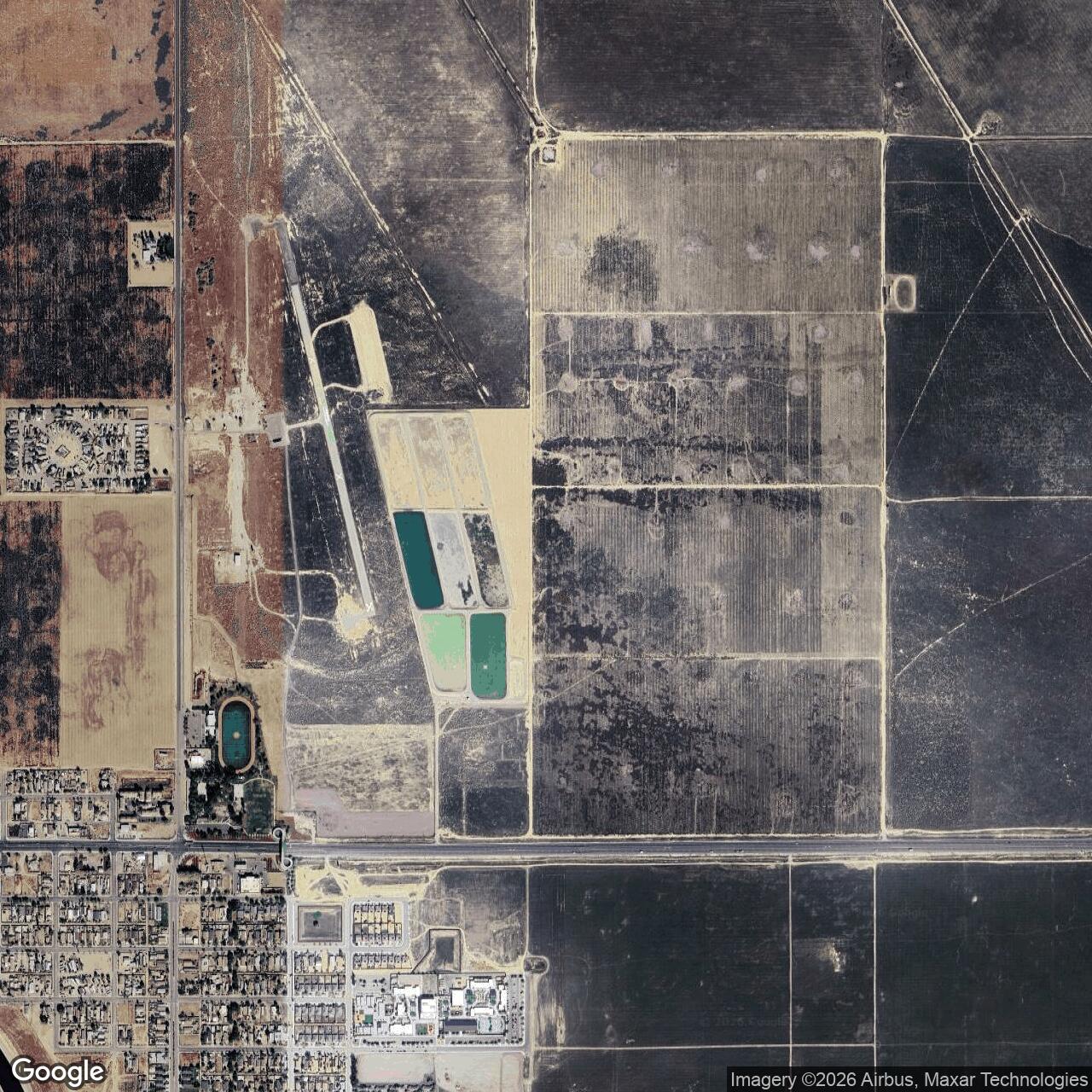
The long civil afterlife also complicates physical archaeology. Some World War II earthwork patterns survived for decades, especially in aerial imagery, while later runway construction, grading, industrial use, agricultural activity, and airport improvements altered other portions. A modern observer can therefore see a former airport landscape without assuming every paved or graded feature is wartime. The surviving runway visible after closure is primarily the later civil Runway 15/33, whereas the Army's main 5,000-foot north-south runway followed a different alignment.
2019 Closure and Current Status
The Federal Aviation Administration published a formal notice on 2019-02-07 concerning Kern County's request to release approximately 336 acres from surplus-property deed and grant-assurance obligations so that Lost Hills Airport could be permanently closed and sold. The notice stated that the land was no longer needed for airport purposes, that there were zero based aircraft, and that no aviation services were available. This federal record is stronger evidence for the end of civil aviation than older web pages that continued to describe Lost Hills as an operating county airport.
The 2019 property was no longer a simple airfield parcel. The FAA described an industrial lease area and water well on the west side, a soccer complex, county park, and fire station on the southwest, and agricultural, sewage-treatment, residential, and commercial uses around the property. Kern County intended to sell the airport land through public auction at fair market value, with proceeds reinvested in Meadows Field and Kern Valley airports. The FAA notice therefore marks both aviation closure and a redistribution of value within the county airport system.
Lost Hills Airport closed in 2019, but the exact post-auction ownership of every portion has not been established. A 2020 sale listing described about 343 acres of former airport property, illustrating another postwar boundary figure. Later aerial evidence is clearer about physical condition than legal title. By 2021 the former airport hangar had been removed. A 2023 aerial view showed three closed-runway X markings on the surviving civil pavement, and an October 2025 aerial image still showed the runway intact with closure markings.
Chronology
- 1933 A USGS aerial photograph did not yet show an airport at the Lost Hills location.
- 1935-12 The Lost Hills Airport appeared on the Los Angeles Sectional Chart, the earliest chart depiction located in the reviewed record.
- 1936 Department of Commerce Airway Bulletin No. 2 described 2,200-foot north-south and 1,600-foot east-west packed-sand runways.
- 1942-11-05 The War Department acquired 160 acres in fee from Jean Atkinson, establishing the first securely documented federal military property date.
- 1943-07-22 An aerial photograph showed the military airfield with two landing surfaces, taxiway circulation, and seven revetted aircraft parking pads east of the main runway.
- 1943-08-30 The War Department acquired another 288.26 acres from Standard Oil Company of California, bringing the documented federal estate to 448.26 acres.
- 1944-02-02 BT-13A 42-89442 of Minter Field's 329th Basic Flying Training Squadron was involved in an accident in the Lost Hills area, 17 miles northwest of Minter.
- 1944-03 The AAF directory described Lost Hills Kern County Airport with a 5,000-foot bituminous north-south runway and 1,600-foot sand-and-clay east-west strip.
- 1945-01 The AAF directory identified the installation as Minter Field Auxiliary No. 7 and recorded a 240-acre operational airfield area, no hangars, no shops, no field fuel, no radio facilities, and no lighting.
- 1945-01-11 The Army classified 63.03 acres of the 448.26-acre federal property as surplus.
- 1945-04-12 AT-10BH 42-35013 of the 450th Base Unit at Hammer Field was involved in a takeoff accident at Lost Hills Auxiliary Field, proving continued military use after the January partial-surplus action.
- 1945-08-10 AT-6C 42-43933 of Minter Field's 3008th Army Air Forces Base Unit was involved in an accident at Lost Hills Auxiliary Field or approximately one-half mile north, documenting Minter use late in the war.
- 1946-03-29 The Federal Farm Mortgage Corporation assumed accountability for the 63.03-acre surplus portion.
- 1946-10-08 The Army declared the remaining 385.23 acres surplus.
- 1948-10-25 The War Assets Administration quitclaimed the former military airfield to Kern County while the United States retained subsurface oil and gas interests in the deed.
- 1956 Aerial photography still showed the World War II runway pattern and eastern dispersal revetments.
- 1966-01-17 An Instrument of Release exempted the airport from the National Emergency Use Provision.
- 1967 Airport documentation showed a reduced 4,500-foot north-south paved runway, with a contemporary AOPA directory reporting approximately 4,000 feet.
- 1968 Kern County developed a new shorter northwest-southeast runway, beginning the transition away from the original military runway geometry.
- 1973 The Flight Handbook depicted the county airport with the later Runway 15/33 configuration and noted parachute activity nearby.
- 1989 An airport survey recorded a 3,600-square-foot hangar, shop building, and mobile home as postwar civil facilities.
- 2008-07-17 California's CEQA record documented a Lost Hills Airport Master Plan covering roughly 387 acres and planning future airport development through 2025.
- 2009 The Kern Regional Aviation System Plan described Lost Hills as a rural general-aviation airport important to agricultural aircraft, with a 3,020-foot runway, tiedowns, hangar spaces, an FBO, and a beacon.
- 2018-06 The Los Angeles Sectional Chart still depicted Lost Hills Airport as active with a single approximately 3,000-foot paved runway.
- 2019-02-07 The FAA published Kern County's request to release approximately 336 acres from federal airport obligations for permanent closure and sale, noting zero based aircraft and no aviation services.
- 2019 Lost Hills Airport closed to aviation.
- 2020 The former airport appeared as abandoned on sectional-chart coverage, while the county pursued sale of roughly 343 acres.
- 2021 Aerial imagery showed that the former civil-airport hangar had been removed.
- 2023 Aerial imagery showed three closed-runway X markings painted on the surviving civil runway.
- 2025-10 Aerial imagery continued to show the former runway intact with closure markings.
- 2026 The former airfield remains closed; surviving runway pavement and mixed surrounding reuse preserve the site's aviation outline.
Information sources (13)
- WEBHistoric California Posts, Camps, Stations and Airfields, "Lost Hills Auxiliary Field"
Source for War Department acquisition acreage, property sequence, military improvements, surplus actions, 1948 conveyance, retained subsurface rights, and 1966 federal release.
- WEBJanuary 1945 Army Air Forces Airfield Directory, Minter Field Auxiliary No. 7 / Lost Hills Field
Primary-period source for coordinates, operational airfield acreage, runway dimensions, ownership and operator fields, approach hazards, road and rail access, and absence of hangars, shops, fuel, radio, and lighting.
- WEBAbandoned & Little-Known Airfields, Bakersfield Area, Lost Hills Airport / Minter Field Auxiliary #7
Source for prewar airport chronology, wartime and postwar aerial interpretation, runway changes, civil-airport development, 2019 closure, and later surviving features.
- WEBFederal Aviation Administration, Federal Register, "Notice of Release From Federal Surplus Property and Grant Assurance Obligations at Lost Hills Airport, Lost Hills, California"
Primary federal source for the 2019 permanent-closure request, approximately 336-acre release, zero based aircraft, absence of aviation services, intended sale, surrounding uses, and 1948 surplus-property deed date.
- WEBCalifornia Governor's Office of Planning and Research, CEQAnet, "Lost Hills Airport Master Plan"
State planning source for the 2008 master-plan process, roughly 387-acre planning area, zoning context, and anticipated airport development phases.
- PDFKern Council of Governments, Kern Regional Aviation System Plan
Regional-government source for Lost Hills Airport's late civil mission, agricultural-aircraft role, 3,020-foot runway, tiedowns, hangar spaces, FBO, beacon, and regional aviation context.
- WEBMinter Field Airport District, "Our History"
Parent-field source for Minter Field's 1941 opening, Army flight-training role, and wartime scale.
- WEBAviation Archaeology, USAAF Accident Reports, February 1944
Accident-index source tying BT-13A 42-89442 of the 329th Basic Flying Training Squadron at Minter Field to the Lost Hills training area on 1944-02-02.
- WEBAviation Archaeology, USAAF Accident Reports, April 1945
Accident-index source identifying AT-10 42-35013 of the 450th Base Unit at Hammer Field at Lost Hills Auxiliary Field on 1945-04-12.
- WEBAccident-Report.com, USAAF Aircraft Accidents and MACRs for April 1945
Independent accident index confirming Kenneth B. Hills, AT-10BH 42-35013, Hammer Field, and the Lost Hills Auxiliary Field takeoff accident on 1945-04-12.
- WEBAviation Archaeology, USAAF Accident Reports, August 1945
Accident-index source tying AT-6C 42-43933 of the 3008th AAF Base Unit at Minter Field to Lost Hills or one-half mile north on 1945-08-10.
- WEBAccident-Report.com, USAAF Aircraft Accidents and MACRs for August 1945
Independent accident index confirming Walter C. Graham, AT-6C 42-43933, Minter Field, and Lost Hills Auxiliary Field on 1945-08-10.
- PDFKern County Board of Supervisors, 2019-04-30 Agenda
County-government source documenting the financial and administrative process connected with closure and sale of Lost Hills Airport in 2019.