Fort Moultrie, South Carolina
Longitude: -79.8556
Official Base Website: Fort Moultrie Historic Site
Current Role: National Park Service historic site and interpreted coastal-defense landscape within Fort Sumter and Fort Moultrie National Historical Park; core Fort Moultrie and Battery Jasper preserved for public interpretation; many former Fort Moultrie Military Reservation buildings and battery/support parcels elsewhere on Sullivan's Island are in municipal, private residential, church, apartment, public-library, or other civilian reuse.
Fort Moultrie is one of the rare American military sites where the entire arc of seacoast defense can be read in one place. A visitor standing inside the preserved fort is not looking at a single moment frozen in time. The same ground carries the memory of a palmetto-log Revolutionary War fort that stopped the Royal Navy, a First System brick work that washed away in a hurricane, a Second System masonry fort that faced Fort Sumter across the harbor, post-Civil War concrete and earth modifications, Endicott-era batteries, World War II command posts, and the end of the old coastal-artillery mission in 1947. Few installations show more clearly how American harbor defense moved from logs and sand, to brick, to concrete, steel, mines, searchlights, telephones, aircraft warning, and joint Army-Navy harbor control.
The name Fort Moultrie refers to a sequence of fortifications on Sullivan's Island rather than to one unchanged structure. The first fort was Fort Sullivan, a partly finished palmetto-log and sand work built in 1776 to guard the sea approach to Charleston. It was renamed Fort Moultrie after Colonel William Moultrie, whose South Carolina defenders defeated Sir Peter Parker's British fleet on June 28, 1776. The second fort, built in the 1790s as part of the young United States' First System of coastal fortifications, was destroyed by hurricane floodwaters in 1804. The third and present Fort Moultrie began in 1807, was completed in 1811, and then changed repeatedly as the Army modified the defenses for new artillery and new threats.
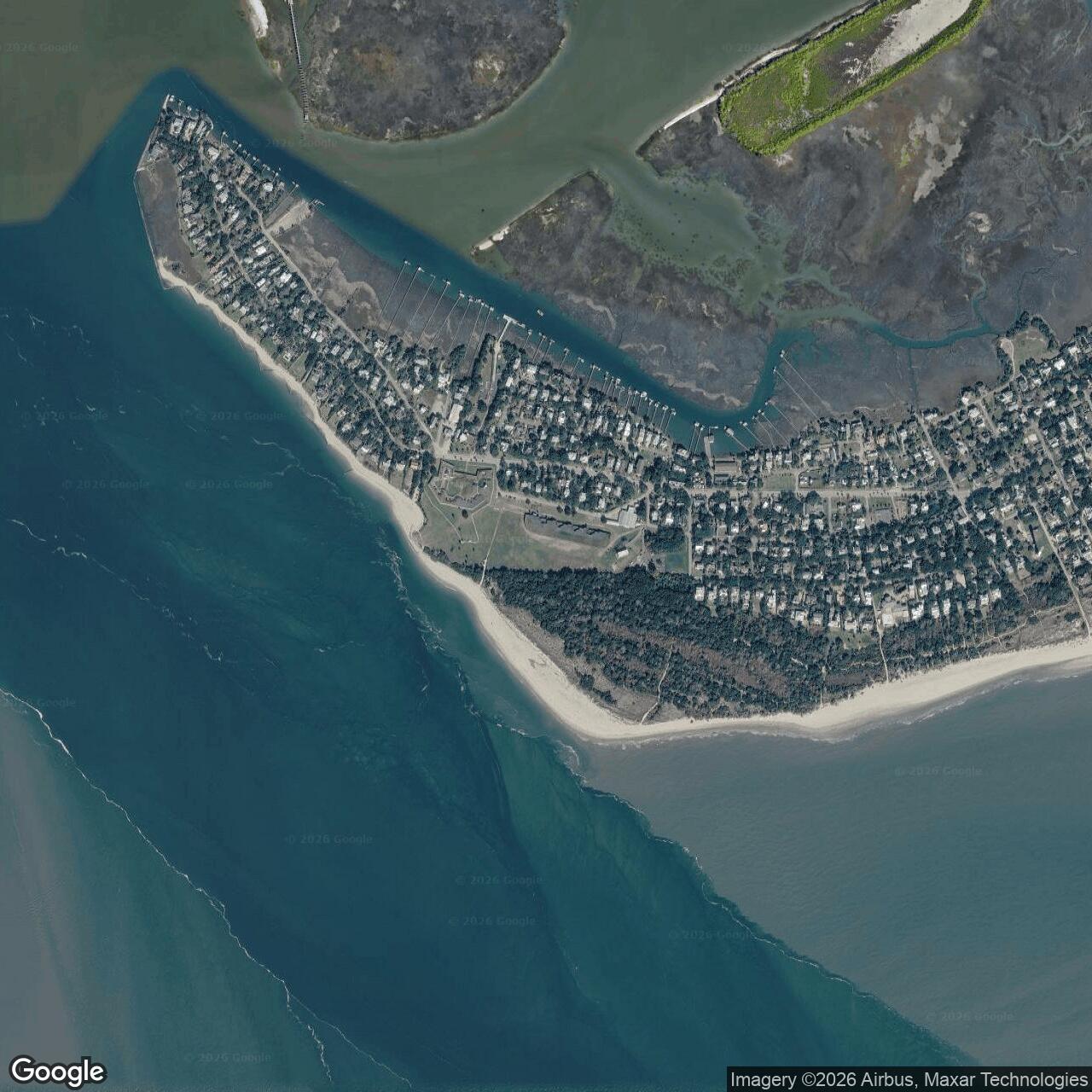
The installation's location explains its importance. Sullivan's Island forms the northeastern edge of the entrance to Charleston Harbor, with the main ship channel passing between the island and Fort Sumter. Fort Moultrie did not defend an isolated beach. It defended Charleston, a major colonial, Revolutionary, antebellum, Civil War, and modern port city. Across its active life the post protected commercial shipping, enforced federal authority, held prisoners, guarded against foreign fleets, fired on Fort Sumter under Confederate control, anchored the Confederate defense of Charleston, served as part of the Harbor Defenses of Charleston, and became the headquarters and physical center of a large World War II military reservation.
Fort Moultrie's status is closed as an active U.S. Army installation. The Army deactivated the Fort Moultrie Military Reservation in 1947, and most of the former reservation was dispersed after the war. The core fort, Battery Jasper, and associated National Park Service lands are now part of Fort Sumter and Fort Moultrie National Historical Park. Many other former Fort Moultrie reservation buildings and battery sites survive in altered form across Sullivan's Island, often as private residences, municipal buildings, churches, apartments, or public facilities. The correct modern status is therefore layered: the Army post is closed, the core historic fort is federally preserved and open to the public through the National Park Service, and much of the former reservation has been absorbed into the civilian townscape of Sullivan's Island.
Mission Evolution
The first military mission at Fort Moultrie was Revolutionary War harbor defense. In 1776 South Carolina built a fort of palmetto logs and sand on Sullivan's Island to block British naval access to Charleston. The work was still incomplete when Commodore Sir Peter Parker and nine British men-of-war attacked on June 28, 1776. The fort's unusual construction proved decisive. Palmetto logs and sand absorbed cannon fire instead of shattering like brittle masonry, while Moultrie's defenders returned fire long enough to damage the British ships and force their withdrawal after a long battle. The victory saved Charleston from immediate occupation and became one of the first major American successes against British naval power.
The first Fort Moultrie did not remain permanently secure. In May 1780 the British finally captured Charleston and Fort Moultrie during the larger southern campaign. During British occupation the fort was known as Fort Arbuthnot. The post returned to American hands when the British evacuated Charleston in December 1782, but after the Revolution the original work decayed rapidly. By 1791 little remained. Its mission had been crucial in 1776, but its physical form was temporary and vulnerable to neglect and weather.
The second Fort Moultrie belonged to the early federal coastal-defense program. In the 1790s, war between Great Britain and France and tension along the Atlantic seaboard pushed Congress to authorize a national system of fortifications. The new United States needed to protect important harbors without relying on a large permanent navy. A second Fort Moultrie, one of the new First System works along the coast, was completed in 1798. It represented the early republic's attempt to turn wartime emergency positions into a planned harbor-defense network. That second work did not last. It was damaged by neglect and destroyed by hurricane floodwaters in 1804.
The third Fort Moultrie, the surviving core fort, grew out of the Second System of coastal defense. Congress responded to the weakness of older works by funding new construction, and work on the present fort began in 1807. By 1809 a new brick fort stood on Sullivan's Island, and HABS documentation states that the fort was completed in 1811. This version of Fort Moultrie enclosed about one and a half acres with earth-filled fifteen-foot brick walls and a parade inside. It belonged to the generation of masonry harbor forts built before the War of 1812, designed to mount heavy guns at harbor entrances and force enemy ships to remain offshore.
Between 1809 and the Civil War, Fort Moultrie changed more in armament and function than in external form. The Army modernized weapons and altered walls, but the larger strategic improvement in Charleston Harbor was the construction of Fort Sumter on an artificial island near the main channel. The harbor system came to include Fort Moultrie, Fort Sumter, Fort Johnson, and Castle Pinckney. These forts were meant to work together against foreign attack. In 1860 and 1861, however, they became opponents in a sectional crisis. Major Robert Anderson and the small U.S. Army garrison occupied Fort Moultrie before moving by night to Fort Sumter in December 1860, leaving Moultrie to South Carolina and then Confederate forces.
During the Civil War, Fort Moultrie's mission changed from U.S. harbor defense to Confederate harbor defense. On January 9, 1861, guns at Fort Moultrie fired on the supply ship Star of the West as it tried to reach Fort Sumter. On April 12, 1861, Confederate batteries, including Fort Moultrie, opened fire on Fort Sumter and began the Civil War. From 1863 through the evacuation of Charleston in February 1865, Fort Moultrie helped defend the harbor against Union ironclads, naval bombardment, and siege operations. The fort was heavily protected with sand because rifled artillery had made exposed brick walls dangerously obsolete.
After the Civil War, the U.S. Army repaired and modernized Fort Moultrie. The 1870s work included concrete, thick earth cover, magazines, bombproofs, and heavier guns. This was a transitional stage between old masonry forts and the later Endicott system. The fort's mission remained Charleston Harbor defense, but the Army increasingly understood that older brick fortifications could survive only if buried, reinforced, and integrated with newer guns and supporting batteries.
The Endicott era turned Fort Moultrie from a compact masonry fort into the center of a much larger military reservation. Beginning in the late nineteenth century, the Army built new concrete and steel batteries on Sullivan's Island, including Battery Jasper, Battery Logan, Battery Bingham, Battery Gadsden, Battery Thomson, Battery Capron, Battery Butler, Battery Pierce, and other elements of the coast-defense system. The old fort became one piece of a reservation that stretched across much of the island. The mission now included disappearing guns, rapid-fire guns, mortars, underwater mines, command-and-control positions, observation, searchlights, quartermaster facilities, barracks, wharves, and a more complex Coast Artillery garrison.
World War II produced the final active military mission. The Fort Moultrie Military Reservation again expanded and adapted as Charleston faced submarine, air, sabotage, and harbor-entry threats. NPS describes the World War II installation as headquarters for coastal defense in the Carolinas. The reservation included anti-aircraft guns, Military Police, Signal Corps activity, a Women's Army Corps detachment, and a Harbor Entrance Control Post and Harbor Defense Command Post jointly operated by the Army and Navy. The mission was no longer simply to fire big guns at visible warships. It was to coordinate harbor control, coastal artillery, anti-aircraft defense, mines, communications, naval coordination, and wartime security.
The Army deactivated Fort Moultrie in 1947. Air power, amphibious warfare, submarines, guided weapons, and nuclear-era strategic thinking had ended the practical usefulness of fixed coastal forts as the nation's primary harbor shield. The reservation was declared surplus, most property was dispersed, and the old core fort and Battery Jasper eventually became preserved historic resources. The mission moved from defense to interpretation, but the site's physical fabric still explains the military system it once served.
Operational Role
Fort Moultrie's operational role was to deny an enemy control of Charleston Harbor's entrance. In 1776 that task was direct and visible. British warships tried to force a passage and suppress the unfinished fort. The defenders used a simple but effective structure, heavy guns, and disciplined fire to resist. The fort's operational success came from geography and material behavior. Sullivan's Island put the fort close to the ship channel, while palmetto logs and sand absorbed shot that might have splintered timber or shattered masonry elsewhere. The result was not only tactical victory, but strategic delay. Charleston remained in American hands at a critical moment early in the Revolution.
During the early republic, the fort's role became deterrent. A garrisoned harbor fort did not need to fight to matter. Its guns, magazines, and visible federal presence complicated the plans of any foreign fleet approaching Charleston. The fort also anchored federal authority on a barrier island whose legal status and public purpose had been shaped by South Carolina and federal military needs for generations. The State of South Carolina ceded land at Fort Moultrie and its dependencies to the United States in 1805, and later cessions produced a patchwork federal footprint on Sullivan's Island totaling nearly 300 acres.
The Second Seminole War gave Fort Moultrie a different operational function: military imprisonment. In late 1837 the United States transferred Osceola and other Seminole prisoners from Florida to Fort Moultrie. NPS records that Osceola had been captured under a false flag of truce, spent his final month at Fort Moultrie as a U.S. Army prisoner, and died there on January 30, 1838. His grave outside the fort's sally port remains one of the most important interpretive features at the site. This episode shows that Fort Moultrie was not only a gun platform. It was also a secure federal post used in the Army's broader campaigns of removal and confinement.
The Nullification Crisis and the antebellum years reinforced Fort Moultrie's political role. Charleston Harbor was not simply a military landscape. It was a place where federal authority, state sovereignty, slavery, commerce, and secessionist ideas collided long before the Civil War. Fort Moultrie, Castle Pinckney, Fort Sumter, and the Charleston Arsenal were symbols and instruments of federal power in a city increasingly hostile to federal intervention. The presence of U.S. soldiers at Fort Moultrie mattered even when the fort was old, vulnerable, and overshadowed by Fort Sumter.
The crisis of 1860 made Fort Moultrie's operational weakness obvious. Major Robert Anderson's garrison judged Fort Sumter more defensible and moved there on the night of December 26, 1860. The abandonment of Fort Moultrie was not a retreat from the harbor, but a tactical concentration at the stronger work. Confederates quickly occupied Fort Moultrie and turned its guns against Sumter. The fort's old purpose was inverted. A position built to defend the United States became one of the batteries firing on a U.S. garrison.
From 1861 to 1865, Fort Moultrie's operational role was central to Confederate Charleston. HABS notes that cannon fire from Fort Moultrie was especially destructive during the initial attack on Fort Sumter. In April 1863, when Federal ironclads attempted to force the harbor, Moultrie engaged them as they tried to pass Forts Moultrie and Sumter. From 1863 until the Confederate evacuation in 1865, Moultrie helped deter Union forces threatening Charleston by sea. Sand protection and earth cover became essential because the old masonry work could not survive Civil War rifled artillery if left exposed.
After the war, Fort Moultrie's role was to translate old harbor-defense geography into newer military technology. The 1870s modifications buried vulnerable structures behind concrete and earth. Endicott batteries then distributed heavier guns along Sullivan's Island. The operational center became less the old brick fort and more the integrated reservation: batteries, magazines, observation stations, fire-control systems, mine casemates, wharves, barracks, quartermaster buildings, and command facilities. Fort Moultrie operated as a node inside a coast-artillery system rather than as a single enclosed fort.
World War II made the command-and-control function especially important. NPS identifies a Harbor Entrance Control Post and Harbor Defense Command Post at Fort Moultrie, jointly operated by the Army and Navy. This reflected the final stage of fixed harbor defense. The problem was no longer simply whether large ships would duel with batteries at close range. The Army and Navy had to manage harbor traffic, underwater mines, anti-aircraft defense, communications, surveillance, and coastal security in a war that included submarines and aircraft. Fort Moultrie was therefore a command post as much as a firing position.
Site Design and Facilities
The first Fort Moultrie was famous because of its design and materials. HABS describes the 1776 fort as a square structure whose walls were about 550 feet long, with inner and outer palmetto-log faces sixteen feet apart and the space between filled with sand. Bastions were planned at the corners, and cannon on the seaward side were mounted on a terreplein of oak planks supported by brick pillars. The fort was intended for a garrison of about 1,000 men, though it was incomplete when attacked. The softness and resilience of its palmetto-log and sand walls became the physical basis of the 1776 victory.
The second Fort Moultrie was a brick First System work built between 1796 and 1798 and destroyed by the 1804 hurricane. Its loss showed a recurring problem for Sullivan's Island defenses: forts built on barrier-island sand at the harbor entrance faced not only enemy fire but storms, flooding, erosion, and shifting terrain. Every version of Fort Moultrie had to contend with the island's environmental instability.
The third fort, completed in 1811, formed the core of the preserved site. HABS describes earth-filled fifteen-foot-high brick walls enclosing about one and a half acres and a parade ground that once contained three brick barracks buildings. The overall fortifications occupied an area roughly 500 feet east-west by 350 feet north-south. The walls, bastions, sally port, magazines, parade, and later concrete emplacements make the present site a layered architectural record rather than a pure 1811 fort.
Civil War and post-Civil War changes altered the fort's design profoundly. Sand cover protected the walls during the Civil War. In the 1870s, the Army repaired the fort and added concrete, bombproofs, and magazines. The sally port, service magazines, postern, retaining walls, and gun emplacements seen today reflect a mix of Second System, post-Civil War, Spanish-American War, World War I, and World War II work. Fort Moultrie is therefore best read as a palimpsest. The exterior shape evokes early masonry seacoast defense, while the interior and surrounding batteries reveal successive rounds of modernization.
The Endicott-era reservation spread beyond the old fort. The National Register documentation for the Fort Moultrie Quartermaster and Support Facilities Historic District describes a cluster of buildings between Middle Street and Thompson Avenue, generally between Station 14 and Station 16 1/2. Those support buildings included a non-commissioned officers' club, post theatre, commissary storehouse, barracks, ordnance storage and office, quartermaster warehouses, dispensary and provost marshal's office, quartermaster's office, and a quartermaster's dock. These facilities remind us that Fort Moultrie was a working Army post, not only a line of guns.
Battery Jasper and the other batteries turned Sullivan's Island into an artillery landscape. NPS's Fort Moultrie Reservation map identifies many former reservation properties, including Battery Jasper, Battery Logan, Battery Gadsden, Battery Thomson, Battery Capron, Battery Marshall, torpedo and mine facilities, quartermaster wharf, barracks, post exchange, chapel, hospital-related buildings, offices, guard house, stables, and WAC-associated barracks use. Many of these properties now have civilian uses or survive only in altered form. Their distribution across the island shows that the name Fort Moultrie referred by the twentieth century to a large military reservation rather than only the old walled fort.
The World War II physical plant included a Harbor Entrance Control Post and Harbor Defense Command Post, anti-aircraft and coastal-defense elements, and reservation-wide support infrastructure. Battery Marshall, built in 1943, and other wartime facilities show the final upgrade of the system before fixed seacoast defense became obsolete. Some facilities were later removed, while others were preserved, repurposed, or absorbed into Sullivan's Island's civilian built environment.
Units, Organizations, and Systems
Fort Moultrie's first defenders were South Carolina patriot forces under Colonel William Moultrie. Their victory in June 1776 made the fort part of South Carolina's Revolutionary identity and helped create the state's later "Palmetto State" symbolism. The defenders included militia and Continental-aligned troops whose mission was to stop a Royal Navy attack before it could open Charleston to occupation.
In the early republic and antebellum period, Fort Moultrie was tied to the U.S. Army artillery and engineer system. The fort's construction, repair, and modernization depended on the national coastal-fortification program, Army engineers, ordnance officers, artillery companies, and War Department appropriations. It was one of the forts through which the federal government tried to maintain a modest but permanent coastal-defense capability.
The post is also associated with Major Robert Anderson's U.S. Army garrison in 1860. Anderson commanded the small federal force in Charleston Harbor at the moment South Carolina seceded. His movement from Fort Moultrie to Fort Sumter reshaped the military crisis. Fort Moultrie remained physically significant, but the U.S. garrison chose Sumter as the stronger point of resistance. Once Confederate forces took over Moultrie, the same fort joined the artillery ring around Sumter.
During the Civil War, Confederate artillery forces made Fort Moultrie one of the principal batteries defending Charleston Harbor. The fort worked in conjunction with Fort Sumter, Fort Johnson, Castle Pinckney, city defenses, and other harbor batteries. Its artillery helped fire on Fort Sumter, resist Union naval attacks, and maintain Confederate control of Charleston until 1865.
In the late nineteenth and twentieth centuries, Fort Moultrie became part of the Coast Artillery and Harbor Defenses of Charleston. The old fort, Battery Jasper, and the distributed Sullivan's Island batteries were not independent posts in practical terms. They formed a system of guns, searchlights, observation stations, minefields, fire-control positions, communications, and garrison support. The Fort Moultrie Military Reservation served as the post and command landscape for that system.
World War II brought a broader garrison community. NPS interpretation for Fort Moultrie's World War II living history highlights Military Police, Signal Corps, and Women's Army Corps roles, while another NPS page notes anti-aircraft guns, the Harbor Entrance Control Post and Harbor Defense Command Post, and a WAC detachment. These organizations reflected the wartime shift from coastal artillery alone to integrated harbor security, communications, joint control, and home-front military administration.
Role in the Wider Military Network
Fort Moultrie belonged first to the Revolutionary War defense of Charleston. Its 1776 victory helped keep the British from taking Charleston early in the war and disrupted hopes of a rapid southern Loyalist campaign. That made Fort Moultrie significant not merely as a local fort, but as part of the wider contest over whether the British could use naval power to secure southern ports and rally Loyalist support.
In the early republic, Fort Moultrie became part of the national seacoast fortification system. The First System and Second System were federal answers to the young nation's vulnerability. The United States had a long coastline, important ports, and limited naval power. Fort Moultrie was one of the places where Congress, the War Department, and Army engineers translated national strategy into masonry, artillery, garrisons, and land cessions.
Within Charleston Harbor, Fort Moultrie functioned as one element in a layered defense network. Fort Sumter guarded the main channel. Castle Pinckney protected the inner harbor. Fort Johnson and other positions helped cover approaches and anchor the harbor system. The Civil War exposed both the power and fragility of that network. The forts were designed to support each other against foreign enemies, but in 1861 they became opposing positions in a domestic war.
The post-Civil War and Endicott eras integrated Fort Moultrie into a more technical national defense architecture. New breech-loading steel guns, disappearing carriages, concrete emplacements, underwater mines, and fire-control systems were standardized across American harbor defenses. Fort Moultrie's batteries were local expressions of a national modernization program that reshaped sites from Maine to California, Hawaii, and the Caribbean.
World War II placed Fort Moultrie inside a coastal-defense network that had to respond to submarines, aircraft, mine warfare, and harbor-control problems. Charleston Harbor remained strategically important, but the tools and threats had changed. The Army and Navy had to coordinate movement, monitor approaches, control mines, defend against air attack, and protect shipping. Fort Moultrie was a headquarters and command landscape in that system, not simply a historic fort with old cannon.
Current Status
Fort Moultrie is closed as an active Army installation and preserved as part of Fort Sumter and Fort Moultrie National Historical Park. The core fort is located at 1214 Middle Street on Sullivan's Island and is accessible by car. NPS interprets the site as a long chronological walk through American seacoast defense, from the 1776 palmetto-log fort through the World War II Harbor Entrance Control Post and the end of the coastal-defense mission.
The preserved National Park Service site includes the old fort, exhibits, visitor center functions, and interpretive landscape. The modern park name dates to the 2019 redesignation of Fort Sumter National Monument as Fort Sumter and Fort Moultrie National Historical Park. NPS states that the law established management authority and defined the boundaries of the park to include Fort Sumter, Fort Moultrie, and the Sullivan's Island Life Saving Station Historic District. Fort Moultrie had been added to the park in 1960 under the Historic Sites Act of 1935.
Much of the former military reservation is no longer federal parkland. NPS's Fort Moultrie Reservation map notes that many batteries and support properties once part of Fort Moultrie are now private property or have been adapted for other uses. The former reservation landscape includes private residences, municipal buildings, churches, public library uses, apartments, and other Sullivan's Island town functions. Battery Jasper and the old fort are federally interpreted, while many other pieces survive as scattered fragments in a living coastal town.
Chronology
- 1674 The Carolina Grand Council ordered a signal cannon placed on Sullivan's Island to alert Charleston to arriving ships and hostile threats.
- 1685 Provincial authorities ordered a watch house on Sullivan's Island to observe possible hostile invasions.
- 1745 A pest house was built on Sullivan's Island, showing the island's long public and quarantine function before the fort.
- 1775-12 South Carolina troops burned the pest house to prevent British use of the site.
- 1776 South Carolina began constructing the first fort on Sullivan's Island, originally known as Fort Sullivan.
- 1776-06-28 Colonel William Moultrie's defenders defeated Commodore Sir Peter Parker's British fleet at the Battle of Sullivan's Island.
- 1776 Fort Sullivan was renamed Fort Moultrie in honor of William Moultrie.
- 1780-05 British forces captured Charleston and Fort Moultrie during the southern campaign; the fort was renamed Fort Arbuthnot during occupation.
- 1782-12 British forces evacuated Charleston, returning the fort to American control.
- 1791 Little remained of the original Revolutionary War Fort Moultrie.
- 1794 Congress authorized the First System of national coastal fortifications.
- 1798 The second Fort Moultrie was completed as one of the new federal coastal forts.
- 1804 Hurricane floodwaters destroyed the second Fort Moultrie.
- 1805 South Carolina ceded Fort Moultrie and its adjacent dependencies to the United States government.
- 1807 Work began on the third and present Fort Moultrie.
- 1809 A new brick fort stood on Sullivan's Island.
- 1811 The third Fort Moultrie was completed.
- 1832-1834 During the Nullification Crisis, Fort Moultrie and other Charleston Harbor federal positions took on renewed political and military importance.
- 1838-01-30 Osceola died at Fort Moultrie as a U.S. Army prisoner and was buried outside the sally port.
- 1860-12-20 South Carolina seceded from the Union.
- 1860-12-26 Major Robert Anderson moved the U.S. garrison from Fort Moultrie to Fort Sumter.
- 1861-01-09 Confederate-controlled guns at Fort Moultrie fired on the supply ship Star of the West.
- 1861-04-12 Fort Moultrie joined the Confederate bombardment of Fort Sumter, opening the Civil War.
- 1863-04 Fort Moultrie engaged Federal ironclads attempting to enter Charleston Harbor.
- 1863-1865 Fort Moultrie helped defend Confederate Charleston during the Union siege and bombardment of the harbor.
- 1865-02 Confederate forces evacuated Charleston; Fort Moultrie returned to U.S. control.
- 1870s The Army repaired and modernized Fort Moultrie with concrete, earth cover, magazines, and bombproofs.
- 1885 The Endicott Board began the modernization process that transformed American coastal defenses.
- 1898 Battery Jasper and other Endicott-era fortification work marked the expansion of the Fort Moultrie reservation.
- 1902 The federal government took possession of much of the land between Station 12 and Station 18 for expansion of the fort.
- 1902-circa 1930 Major construction of garrison housing and support facilities expanded the Fort Moultrie Military Reservation.
- 1915-1921 Army maps show many reservation buildings and support facilities, including barracks, chapel, quartermaster areas, wharf, offices, and residential support structures.
- 1941-1945 World War II brought anti-aircraft defense, harbor-control functions, communications, military police, WAC activity, and expanded reservation use.
- 1943 Battery Marshall appeared as part of the World War II Fort Moultrie defense landscape.
- 1943-1946 A WAC detachment used one of the Fort Moultrie barracks buildings, according to the NPS reservation map.
- 1947 Fort Moultrie was deactivated and most of its property was dispersed through surplus-property channels.
- 1947-08-15 The Fort Moultrie flag came down and the Army ended active service at the post.
- 1949-12-28 Former military property on Sullivan's Island was delivered to the Sullivan's Island Township Commission.
- 1960 Fort Moultrie was added to the Fort Sumter park unit under the Historic Sites Act of 1935.
- 1963-04 Fort Moultrie opened to the public as an interpreted historic site.
- 2007 The Fort Moultrie Quartermaster and Support Facilities Historic District was documented as a National Register historic district.
- 2019-03-12 The John D. Dingell, Jr. Conservation, Management and Recreation Act was signed, redesignating the park as Fort Sumter and Fort Moultrie National Historical Park.
- Present Fort Moultrie is preserved by the National Park Service as a public historic site interpreting American seacoast defense from the Revolution through World War II.