
Texas Tower No. 1 / Cashes Ledge Planned Radar Station, New Hampshire
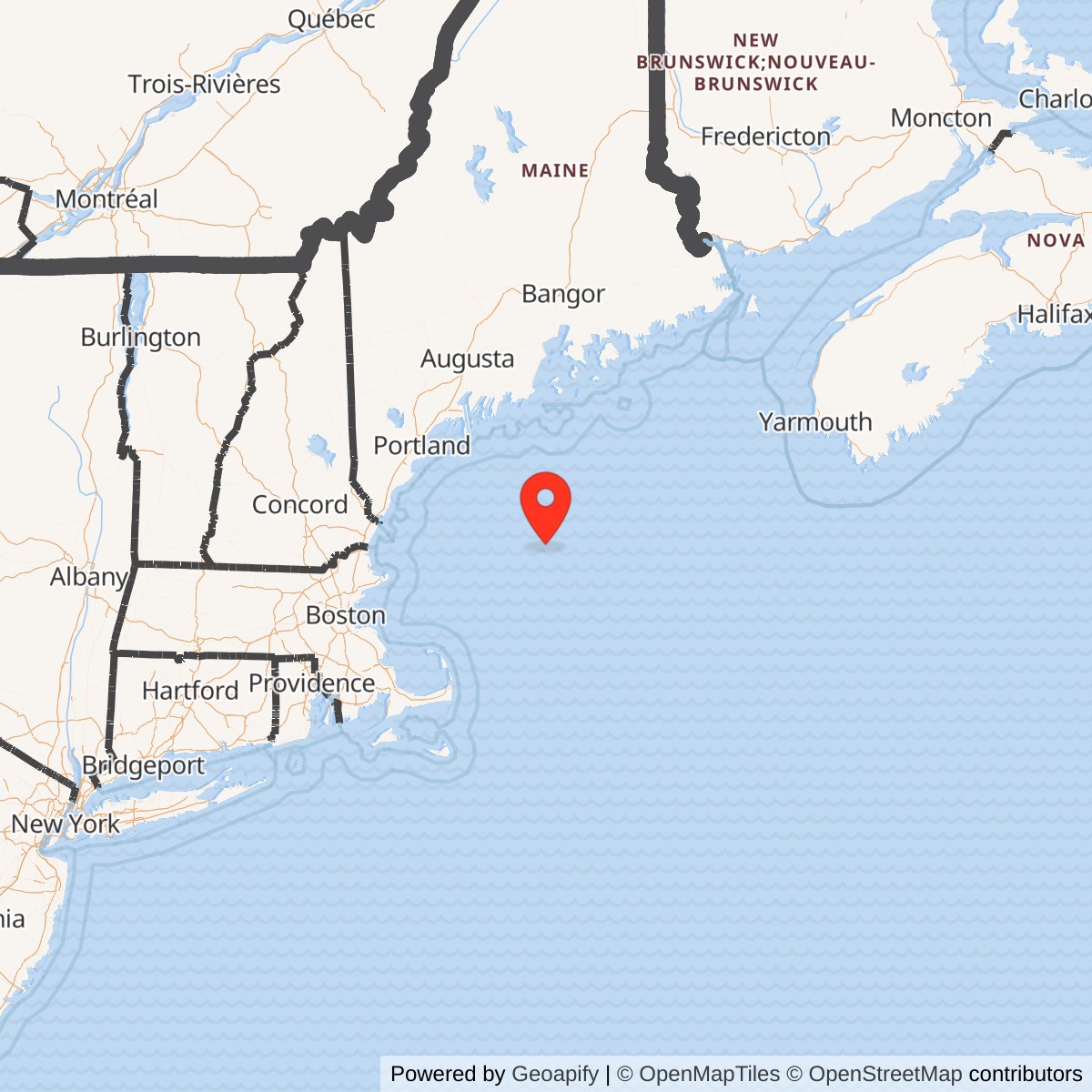
Longitude: -68.95
Site Number: TT-1
Official Base Website: Cashes Ledge
Current Role: Natural Cashes Ledge submarine ridge and marine habitat in the Gulf of Maine. Parts of the area are regulated by NOAA Fisheries as habitat-management or groundfish-closure waters. No Air Force platform, foundation, radar, wreck, military debris field, or active military use exists at the planned TT-1 point.
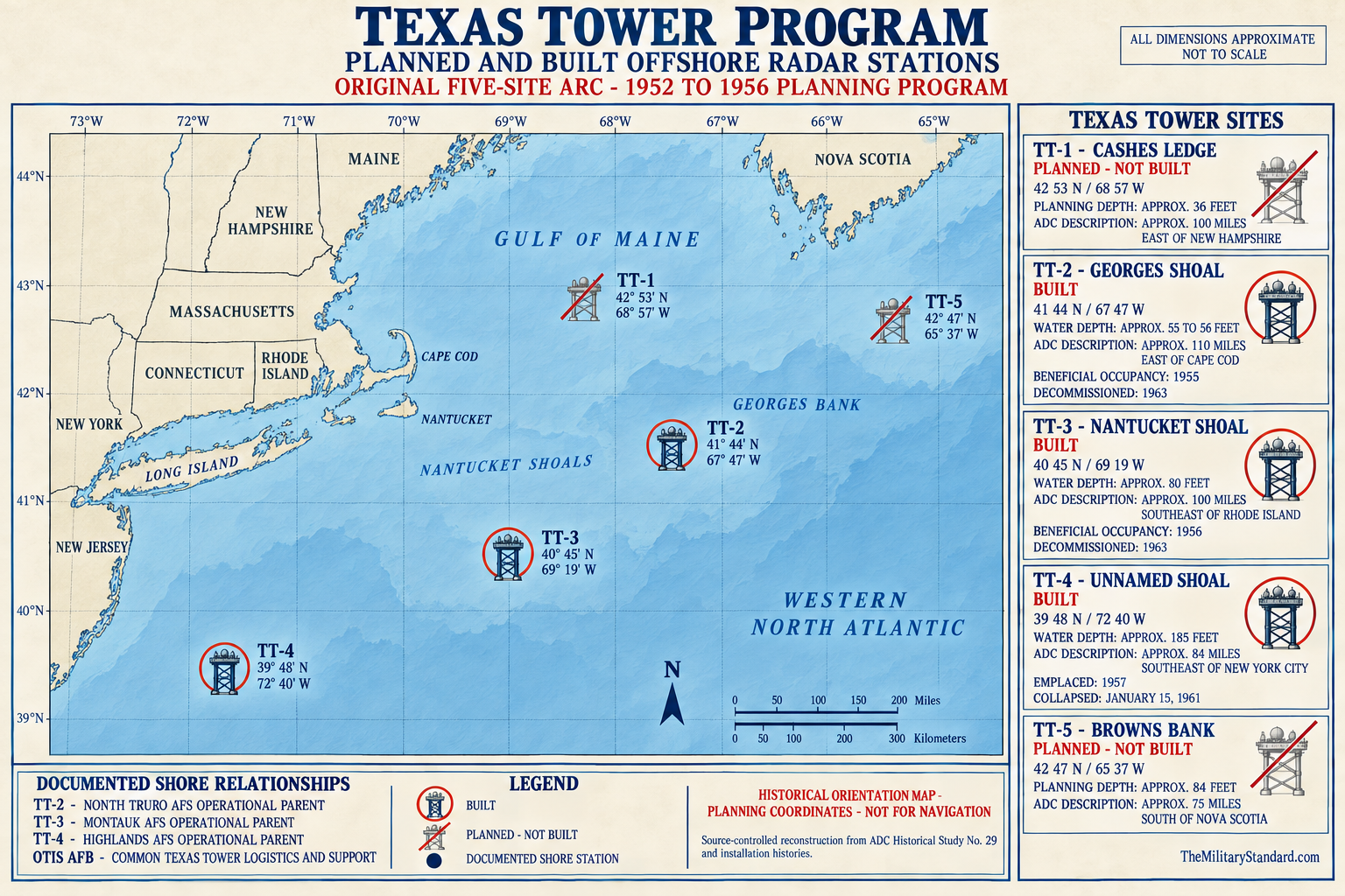
Texas Tower No. 1 was an authorized but unbuilt United States Air Force offshore radar station proposed for Cashes Ledge in the Gulf of Maine. It belonged to the original five-site Texas Tower program developed by Air Defense Command and MIT Lincoln Laboratory to extend continental aircraft warning seaward. The Air Force assigned the project designation TT-1 and approved it as part of the program, while the Navy managed site surveys and engineering. It was canceled in late 1956 before fabrication, emplacement, military occupancy, radar activation, or assignment of an operating crew.
The absence of a completed platform does not make TT-1 historically empty. Its selection records where planners believed a serious low-altitude radar gap existed, and its cancellation records how quickly air-defense technology and economics changed. TT-1 links Cashes Ledge to the Cape Cod experimental radar system, shore-based Aircraft Control and Warning stations, Navy picket ships, airborne early-warning aircraft, the future SAGE network, and the three Texas Towers that were built. It is best understood as a documented defense project that reached authorization and site-study stages but never became a physical military installation.
TT-1 was expected to use a fixed steel platform, heavy long-range search radar, height finders, identification equipment, communications, power generation, crew quarters, a helicopter deck, and marine resupply arrangements comparable to the system later demonstrated at TT-2. None of those facilities was installed at Cashes Ledge. Statements about the intended tower describe program plans and design analogs, not archaeological remains or an operating record.
The site also has a substantial history unrelated to the military proposal. Cashes Ledge is a prominent underwater ridge roughly 80 to 100 miles east of the New Hampshire coast, centered on the shallow Ammen Rock area and surrounded by deeper Gulf of Maine water. It supports kelp forests, groundfish habitat, scientific study, and regulated fishing areas. Modern environmental protections concern the natural marine ecosystem and fisheries, not cleanup of a constructed Texas Tower, because TT-1 left no platform or known military debris field.
Installation Identity, Name, and Scope
Texas Tower No. 1, Texas Tower 1, TT-1, and Cashes Ledge refer to one proposed radar project. The numeric designation was not chronological proof that it was built first. It identified the northernmost site in the original planned sequence. Texas Tower No. 2 at Georges Shoal became the first platform constructed and occupied, while TT-1 remained on paper. This is why program histories can discuss the first operational Texas Tower while calling it TT-2 without contradiction.
TT-1 should not be merged with North Truro Air Force Station, or Portsmouth Air Force Station, later renamed Rye Air Force Station, Grenier Air Force Base, Portsmouth Air Force Base, later renamed Pease Air Force Base, Brunswick-area radar sites, or any later Gulf of Maine surveillance facility. Those were land installations with their own property, units, and missions. Cashes Ledge was a separate proposed offshore sensor position intended to complement the coastal network. It never acquired buildings, a garrison, or a formal land parent relationship that would erase its independent project identity.
The record must also distinguish authorization from construction. The Secretary of the Air Force authorized a five-tower program in autumn 1953, and later summaries associate specific TT-1 project approval with January 11, 1954. The Navy then conducted or managed survey and engineering work for all five locations. A construction contract was awarded only for the first selected platform at Georges Shoal, TT-2. No evidence shows that Bethlehem Steel or another contractor began fabricating a platform specifically for Cashes Ledge.
For catalog purposes, TT-1 is assigned to New Hampshire because historical site lists describe it as off the New Hampshire coast and because its expected shore-support geography lay in northern New England. This is an indexing choice, not a claim that the proposed point stood within New Hampshire territorial waters. The project was far offshore in the Gulf of Maine, and any legal jurisdiction for construction would have required federal maritime and international analysis beyond ordinary state property practice.
Location, Geography, and Representative Coordinate
Cashes Ledge is an underwater mountain chain and ridge system in the central Gulf of Maine. The crest rises sharply from surrounding basins, and Ammen Rock approaches close to the surface. Modern scientific sources place the ridge approximately 145 kilometers east of New Hampshire and describe a biologically rich kelp-forest system centered near Ammen Rock. The strategic value in the 1950s came from the same geography: shallow water far from shore offered a possible foundation for a fixed radar platform.
Later Texas Tower compilations place TT-1 near 42 degrees 53 minutes north latitude, 68 degrees 57 minutes west longitude, converted here to 42.883333, -68.950000. That point is used as a representative planned-site coordinate. It is not identified in the available primary records as a final surveyed caisson center, construction stake, lease boundary, exclusion zone, or modern navigation position. The feasibility survey likely considered seabed conditions across a broader candidate area before cancellation ended detailed development.
Modern geographic sources give slightly different points for Cashes Ledge and Ammen Rock. NOAA Fisheries defines a Cashes Ledge Habitat Management Area extending from 42 degrees 45 minutes to 43 degrees 1 minute north and from 68 degrees 52 minutes to 69 degrees west. A scientific study placed one Ammen Rock sampling site at approximately 42 degrees 53.4348 minutes north and 68 degrees 56.6106 minutes west. These current coordinates describe natural features or management areas, not the canceled military project.
Secondary program histories report that the proposed location was about 100 miles off New Hampshire in approximately 36 feet of water. The water-depth figure is plausible near the shallow crest but should not be applied to the entire ridge. Cashes Ledge contains strong relief and varying depth, and a tower would have required a final geotechnical point suitable for caissons. No surviving evidence reviewed proves that such a final construction point was approved.
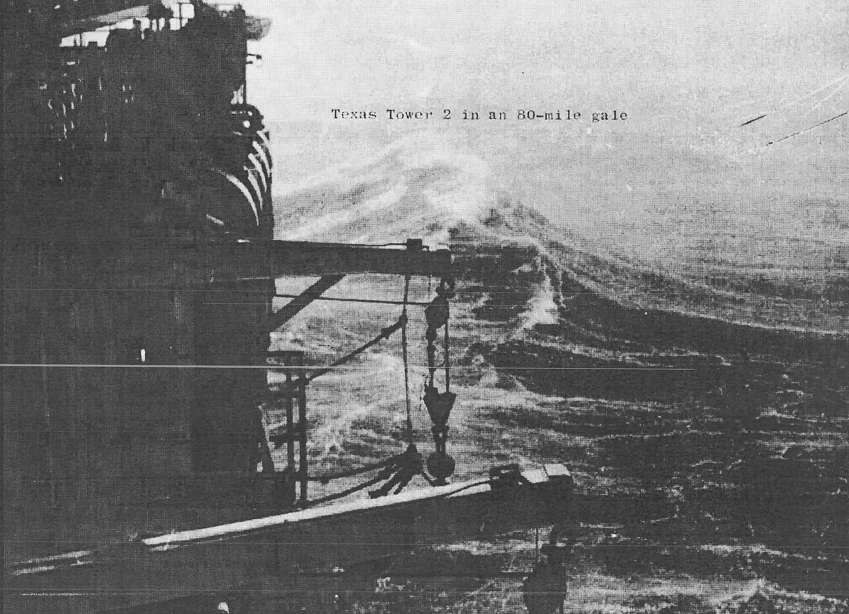
The planned location offered both advantage and difficulty. It was far enough offshore to move the radar horizon seaward, yet shallow enough for the fixed platform concept under consideration. At the same time, the Gulf of Maine exposed any structure to fog, winter storms, waves, icing, corrosion, currents, and difficult logistics. The unbuilt status means those risks were evaluated through survey and analogy rather than experienced by a TT-1 crew.
Strategic Requirement
The Soviet atomic-bomber threat drove the seaward-extension program. By the early 1950s the United States was building a continental radar network, but coastal stations could not see indefinitely beyond the curvature of the earth. A bomber flying low over the Atlantic could remain below a shore radar's line of sight until relatively close to the coast. Moving a radar to Cashes Ledge promised earlier detection along northern approaches to New England and the industrial Northeast.
Air Defense Command did not expect TT-1 to act alone. The proposed tower was one element of a layered system that included land-based search radars, height finders, Ground Observer Corps posts, fighter-interceptor bases, Navy radar picket vessels, airborne early-warning aircraft, communications networks, and command centers. Its purpose was to add a persistent offshore sensor where geography created a gap. The value lay in track geometry and warning time, not in weapons located on the platform.
MIT Lincoln Laboratory examined fixed offshore stations while developing the Cape Cod System and concepts that matured into SAGE. On August 1, 1952, the laboratory proposed using oil-platform principles to carry heavy radars over shallow offshore banks. Unlike a picket ship, a fixed station could support large land-type antennas without ship motion and remain continuously on location. Unlike an aircraft, it did not consume fuel simply to stay on station, though it created its own construction and life-support costs.
Program estimates suggested that the completed tower chain could extend contiguous East Coast radar coverage approximately 300 to 500 miles seaward and provide at least thirty additional minutes of warning against some bomber approaches. Those were system-level expectations, not guaranteed TT-1 performance figures. Actual warning would have depended on target altitude, radar cross-section, atmospheric propagation, equipment readiness, communications, track recognition, and the relationship between the tower and neighboring sensors.
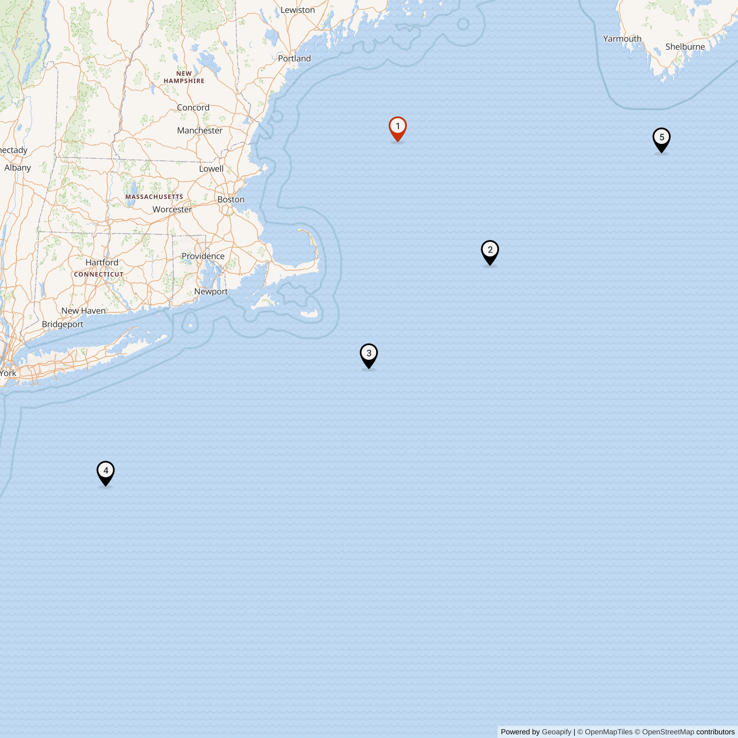
The selection of Cashes Ledge shows that planners were thinking beyond a simple line parallel to shore. TT-1 would have covered the northern end of the tower arc, while TT-2 at Georges Shoal, TT-3 at Nantucket Shoal, TT-4 on Unnamed Shoal, and TT-5 at Browns Bank extended the concept south and northeast. The design attempted to place sensors on naturally shallow offshore elevations rather than construct foundations in unrestricted deep water.
Program Authorization and Project Development
In autumn 1953 the Secretary of the Air Force authorized construction of five Texas Towers on Air Defense Command's recommendation. A later TT-1 summary gives January 11, 1954 as the specific approval date for Tower No. 1. These statements can coexist if the autumn action authorized the overall program and the January action approved or recorded the site project. No available document shows that January 11 was a construction-start date.
The Navy Bureau of Yards and Docks became the Air Force's design and construction agent. The arrangement drew on Navy experience with marine surveying, foundations, corrosion, weather, and offshore contracting. The Air Force retained the operating requirement and radar mission, while Air Force engineering representatives monitored the work and technical organizations supported equipment planning. Dividing responsibility made use of specialized expertise but required clear coordination among commands, engineers, and contractors.
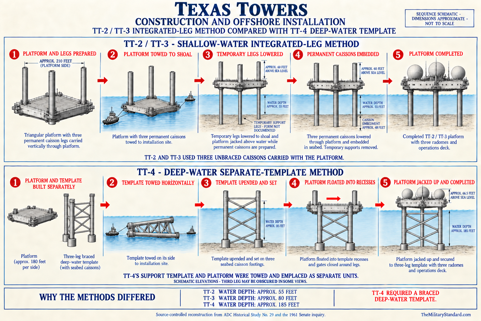
In March 1954 the Air Force authorized the Bureau of Yards and Docks to prepare contract plans and specifications. The service assigned project numbers to TT-1 at Cashes Ledge, TT-2 at Georges Shoal, TT-3 at Nantucket Shoal, TT-4 at Unnamed Shoal, and TT-5 at Browns Bank. Assignment of TT-1 is therefore an official planning act, not a later historian's invention. It established the proposed installation in the program even though physical work never followed.
The Navy contracted with the DeLong Corporation and Raymond Concrete Pile Company joint venture in July 1954 to obtain core drillings. Engineering firms conducted site surveys during the summer with assistance from those companies and other agencies. Their October 1954 feasibility report became the survey basis for further design. Cashes Ledge was included in this five-site examination, but the public histories do not reproduce a site-specific boring log, final foundation recommendation, or precise TT-1 plan sheet.
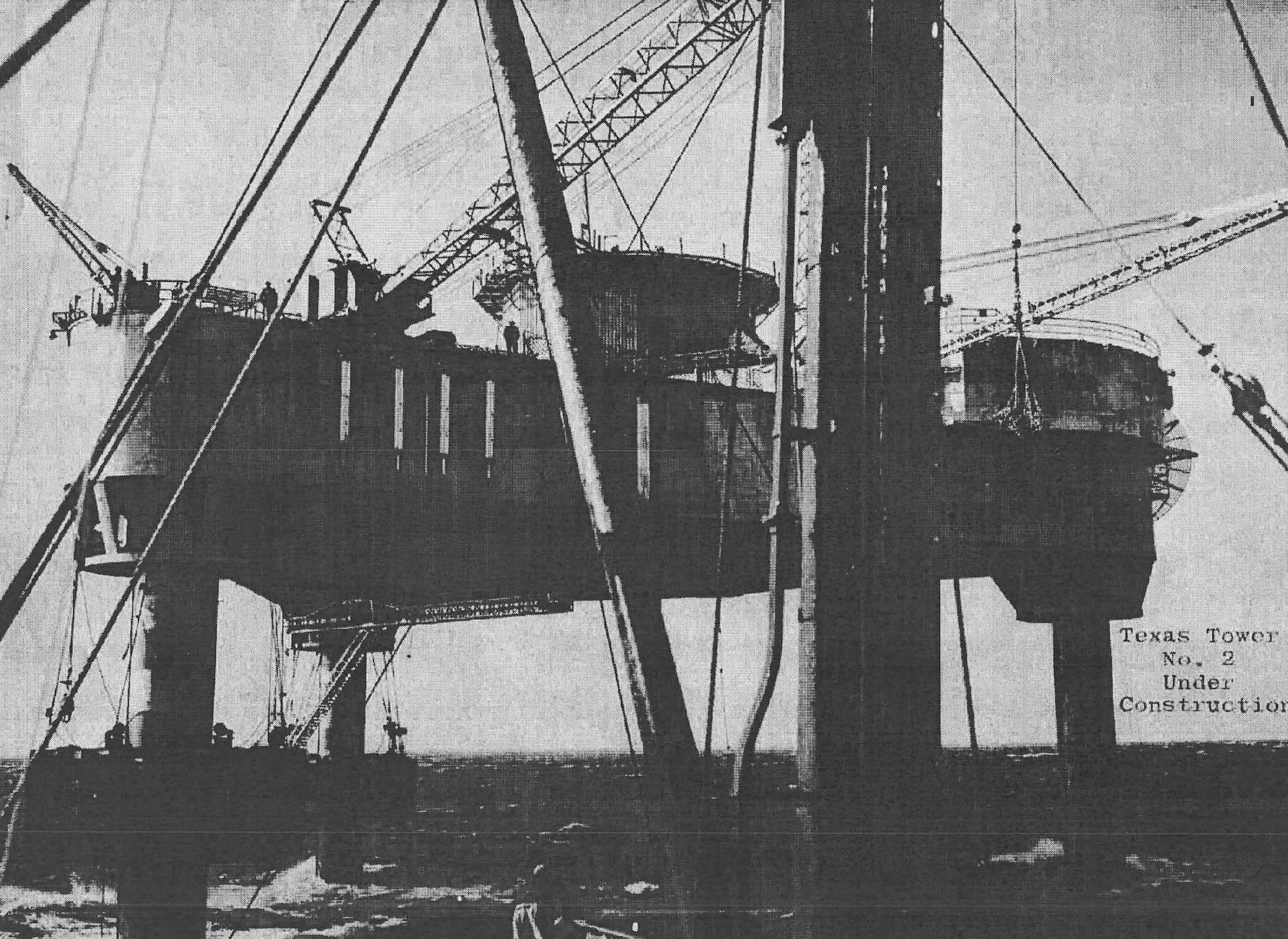
In December 1954 the Navy awarded Bethlehem Steel a contract to build the first platform. Air Defense Command selected Georges Shoal, TT-2, because its relatively shallow water and position near the first semi-automatic air-defense system made it the most useful initial test. That choice did not cancel TT-1. It placed Cashes Ledge behind the prototype so planners could learn from the first platform before committing the remaining sites.
Intended Design and Facilities
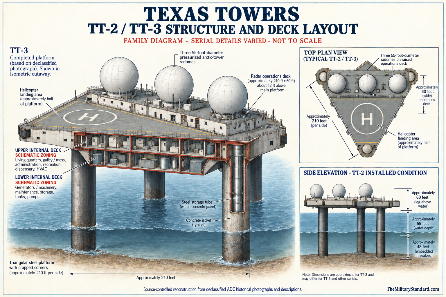
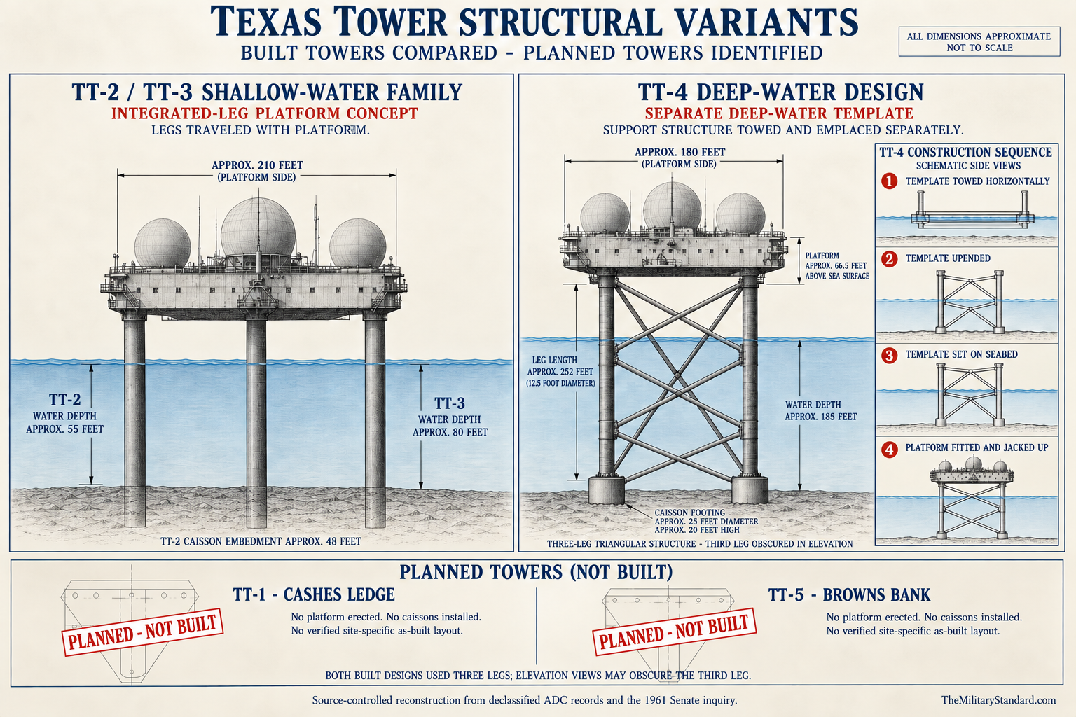
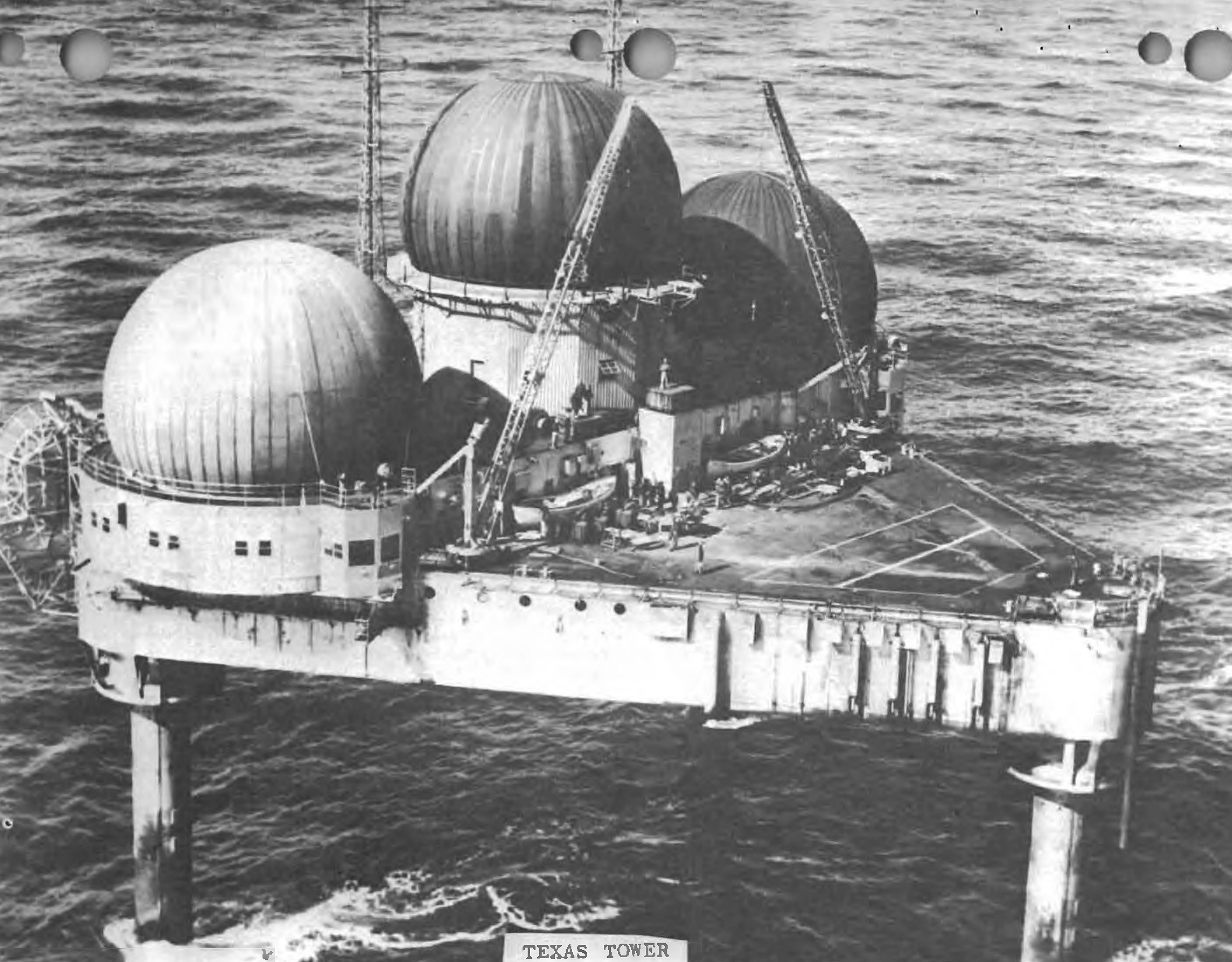
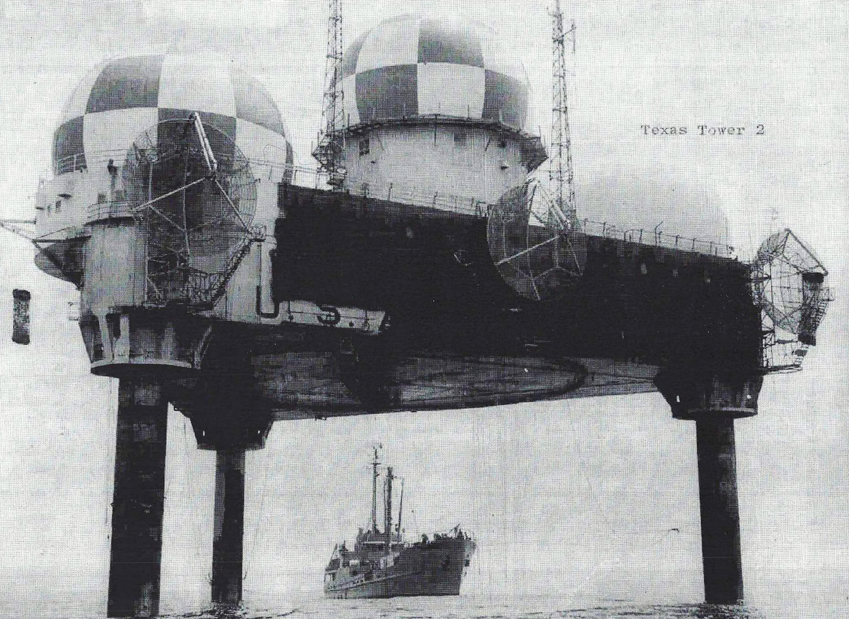
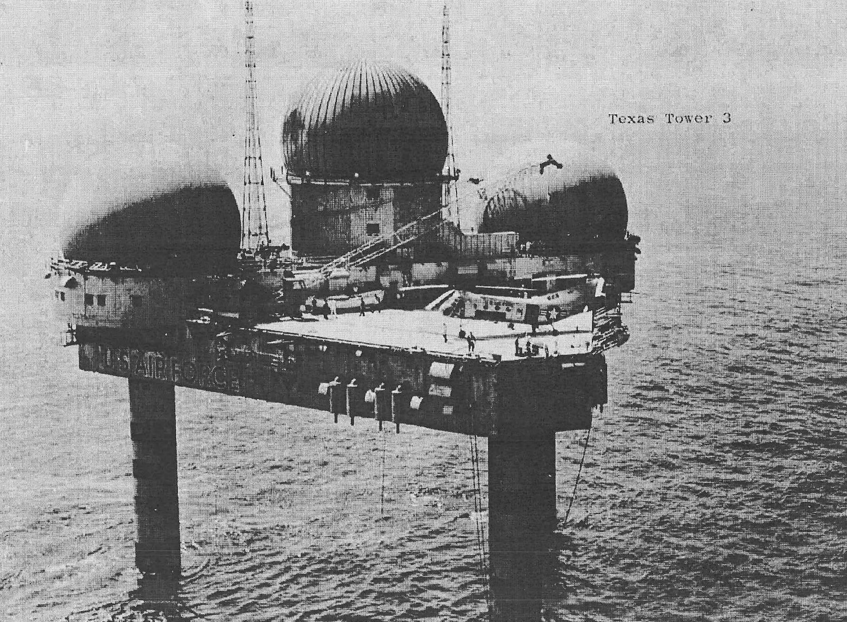
The common Texas Tower design provides the best evidence for what TT-1 was intended to become, but every feature must be labeled as planned. The prototype platform was a cropped equilateral triangle roughly 210 feet on each side, with approximately half an acre of surface and an enclosed body about 20 feet deep. It combined operations, living, machinery, storage, and aviation space. A Cashes Ledge tower likely would have followed that family unless final engineering required site-specific changes.
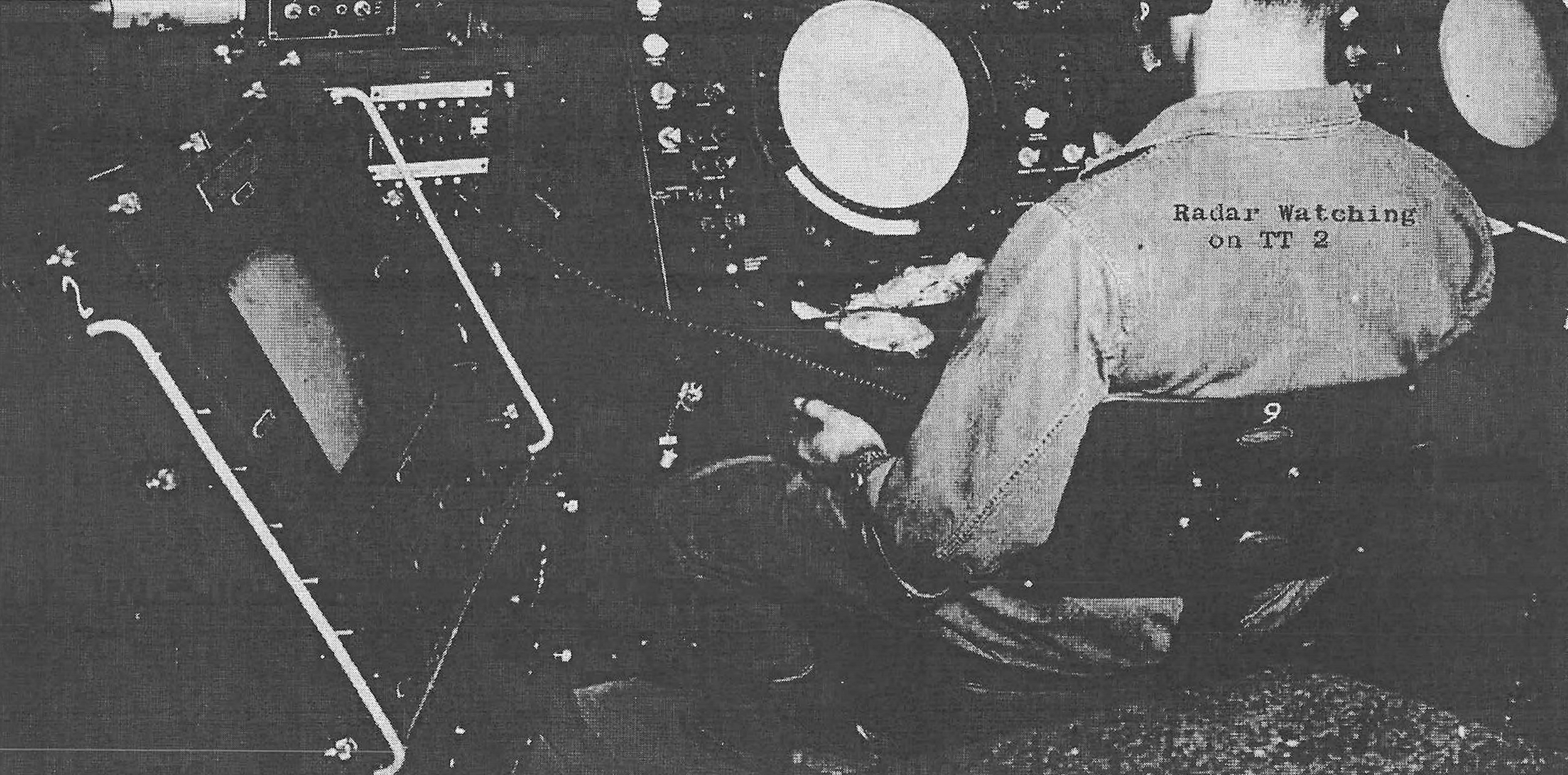
The lower portions of a completed tower contained pumps, tanks, machinery, maintenance shops, and storage. A living deck provided bunks, galley and mess, administration, recreation, medical space, food storage, heating, ventilation, and air conditioning. Above it, a raised operations deck housed radar displays, communications, processing equipment, and control positions. A helicopter landing area occupied another part of the upper surface.
Three radomes formed the expected radar profile. One protected the long-range search antenna and two protected height finders. The search radar would have supplied range and bearing, while height-finder crews measured altitude. Identification and communications equipment would have turned those measurements into a track that a command center or fighter controller could use. No radome, antenna, equipment shelter, or foundation was erected at Cashes Ledge.
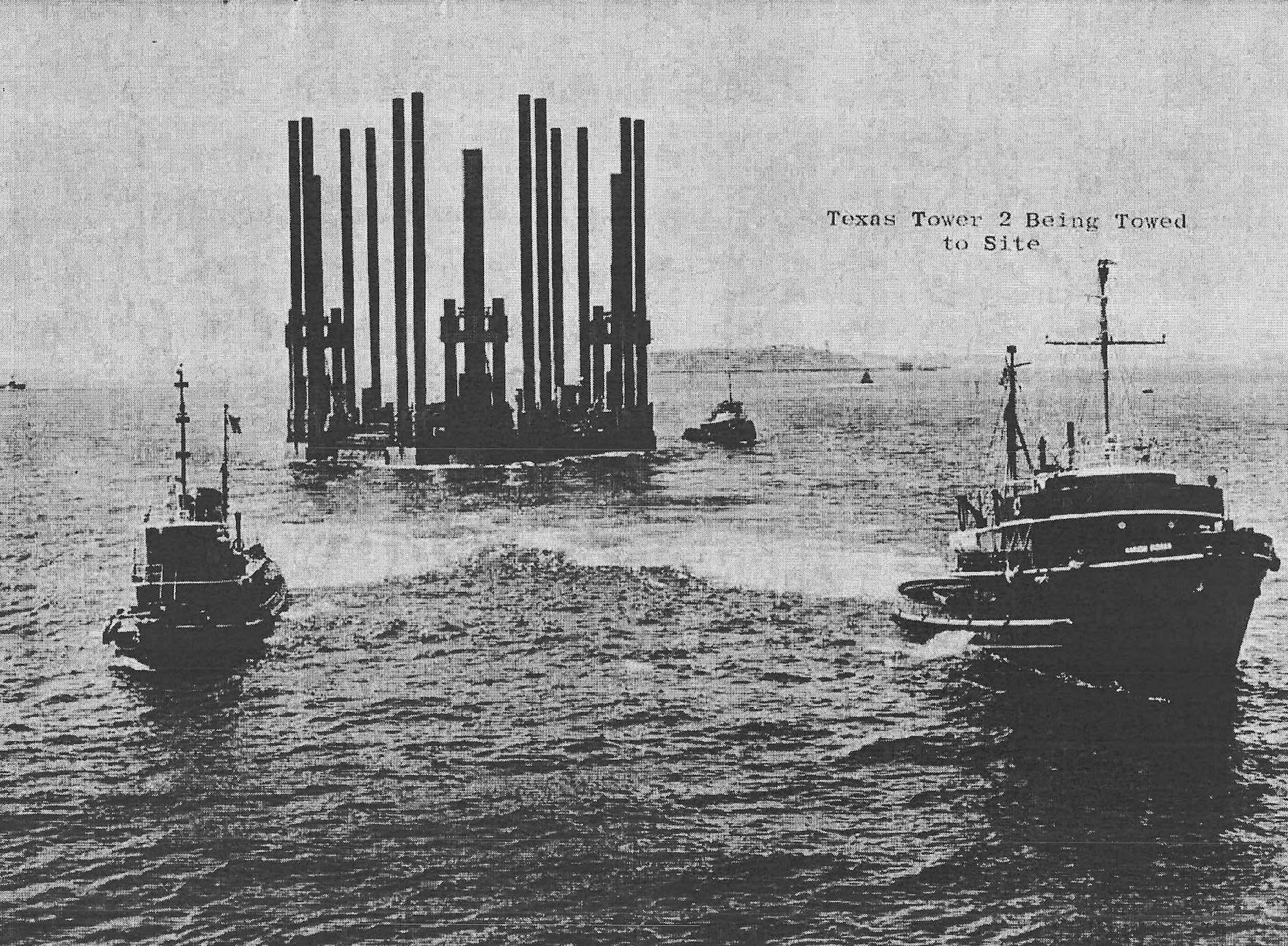
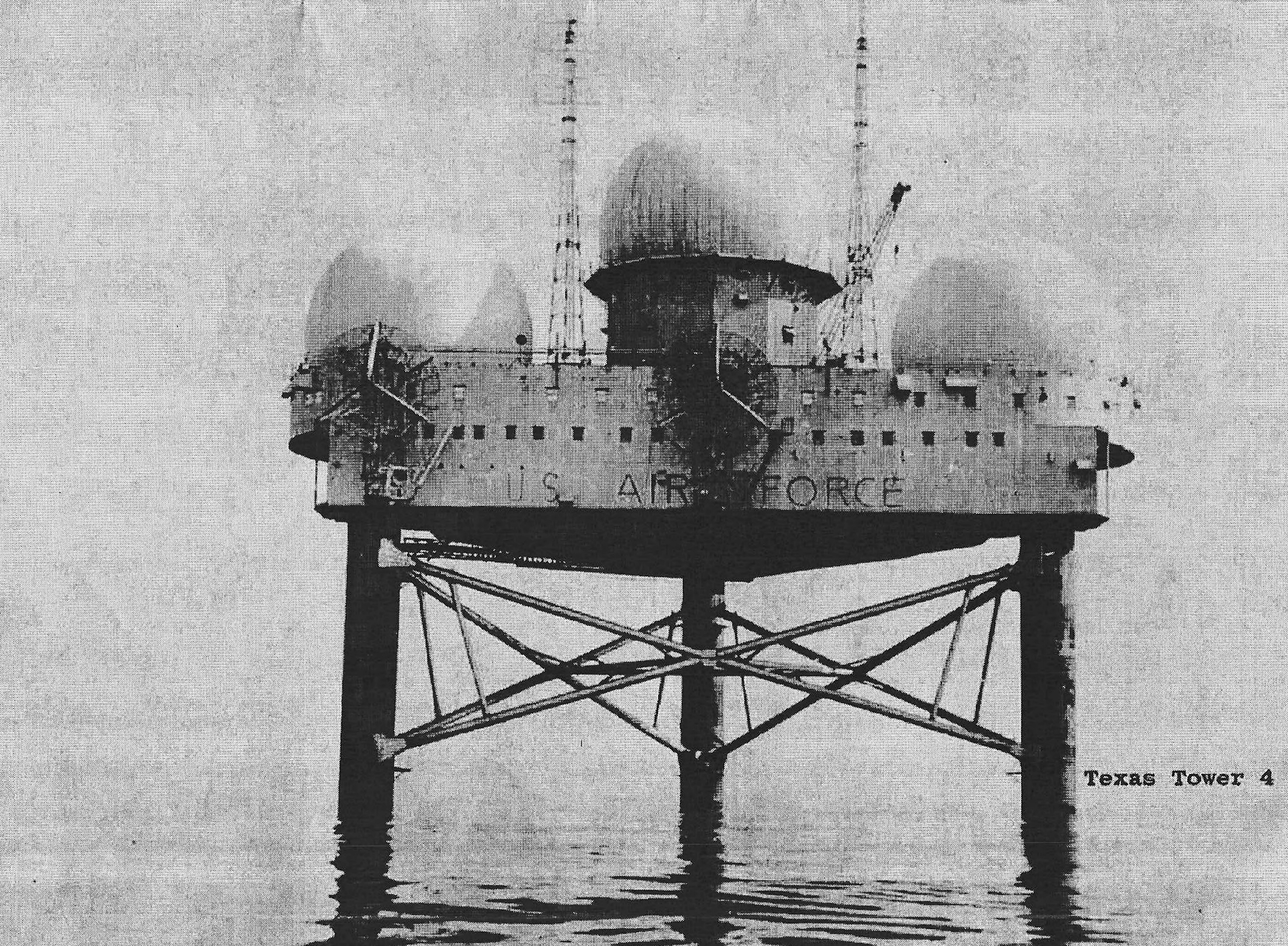
The TT-2 prototype stood on three large tubular caissons embedded into the seabed. Its legs also housed seawater intake, sanitary discharge, fuel, water, and utility connections. A TT-1 design for approximately 36 feet of water might have used shorter legs than later towers, but no released final drawing establishes its exact dimensions. It is inaccurate to place TT-2's completed measurements onto TT-1 as though construction occurred.
Electrical generation would have been essential because the site had no shore power. The completed prototype used multiple diesel generators with enough redundancy to allow maintenance and failure while radars, radios, lighting, heating, ventilation, galley, water production, and safety systems remained active. Fuel storage and tanker transfer were integral to the design. Cashes Ledge never received tanks, fuel, generators, or electrical equipment under the canceled program.
The intended habitat had to sustain personnel through periods when fog or storms stopped transportation. Completed towers held food, fuel, lubricants, spare parts, freshwater production equipment, medical supplies, and firefighting systems. The design was closer to a self-contained industrial station than a simple radar pedestal. TT-1's cancellation eliminated not only a sensor but an entire proposed offshore community and logistics chain.
Intended Radar and Communications Mission
The original tower equipment concept used an AN/FPS-3 family long-range search radar and two AN/FPS-6 height finders. TT-2 received an AN/FPS-3A and two AN/FPS-6 sets, then underwent modernization as the radar network evolved. TT-1 would probably have used the same initial family if constructed on the original schedule. No equipment was procured, delivered, installed, activated, or removed at Cashes Ledge based on the evidence reviewed.
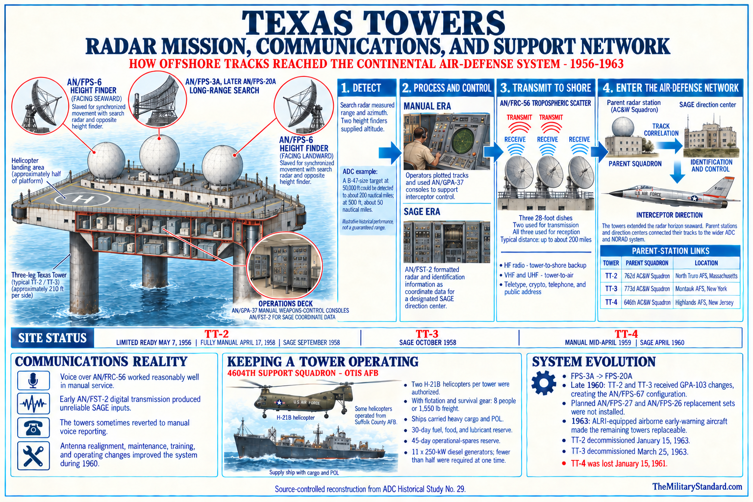
Radar data had to reach shore to have operational value. The completed tower system used high-capacity tropospheric-scatter communications, conventional high-frequency backup, UHF and VHF air-ground radio, telephone, teletype, cryptographic equipment, identification systems, and later digital data transmission for SAGE. A TT-1 link would have required a corresponding shore terminal and frequency plan. No confirmed TT-1 communications terminal or dedicated onshore annex has been identified.
Ground-controlled interception was part of the intended function, but the tower would not have launched interceptors. Radar operators and controllers would detect, identify, track, and report aircraft, while fighter bases supplied armed aircraft. SAGE direction centers would eventually combine TT-1 data with other sensors and assign interceptions. The distinction matters because an offshore radar station was an information node, not an independent combat base.
The radar horizon remained an inherent limit even offshore. High-altitude aircraft could be detected at long range, while low aircraft would remain below line of sight until closer to the tower. Weather and temperature inversions could create anomalous propagation, persistent echoes, or coverage gaps. TT-1 would have improved geometry but would not have made the Gulf of Maine transparent at every altitude and under every atmospheric condition.
Planned Units, Parentage, and Support
Later radar-site indexes associate TT-1 with the 762d Aircraft Control and Warning Squadron, the same North Truro unit that operated TT-2. That assignment is plausible because North Truro faced the Gulf of Maine and already held the operational relationship with the prototype. However, no evidence reviewed shows that the 762d activated a staffed TT-1 flight or assigned a permanent Cashes Ledge crew. The relationship is recorded as planned or indexed parentage, not an accomplished unit assignment.
The 4604th Aircraft Control and Warning Squadron (Texas Towers), activated at Otis Air Force Base in September 1956 and redesignated the 4604th Support Squadron in December, became the specialized logistics organization for completed towers. Had TT-1 survived, the 4604th system would likely have supported it, possibly with northern staging through Pease or another New England base. Because cancellation occurred as that support organization was forming, no TT-1 logistics detachment reached operational status.
Pease Air Force Base offered a logical northern aviation and supply node, but the available evidence is clearer for planned Pease support of TT-5 than for a fully approved TT-1 arrangement. Secondary accounts sometimes compress the support plan or apply the completed-tower structure retroactively. This history therefore identifies Pease, Otis, and North Truro as likely or proposed network partners where supported, without claiming a TT-1 tenant compound existed at any of them.
An operating crew would probably have resembled the mature Texas Tower complement of approximately six officers and forty-eight airmen, supplemented at times by civilian technicians. Radar operations, communications, power, water, refrigeration, food service, medical care, administration, maintenance, and emergency response all required specialists. The initial program estimate of twenty-two personnel proved inadequate on completed towers, but TT-1 never acquired an authorized on-site strength that can be treated as actual staffing.
Planned Logistics and Human Experience
Helicopters were central to personnel movement and light cargo on the completed towers. The Air Force originally used H-21B aircraft equipped with flotation and survival gear, which reduced passenger and cargo capacity. A Cashes Ledge station approximately 100 miles offshore would have required a carefully planned helicopter route, weather alternates, fuel reserves, and shore maintenance. No documented helicopter landed at TT-1 because there was no deck.
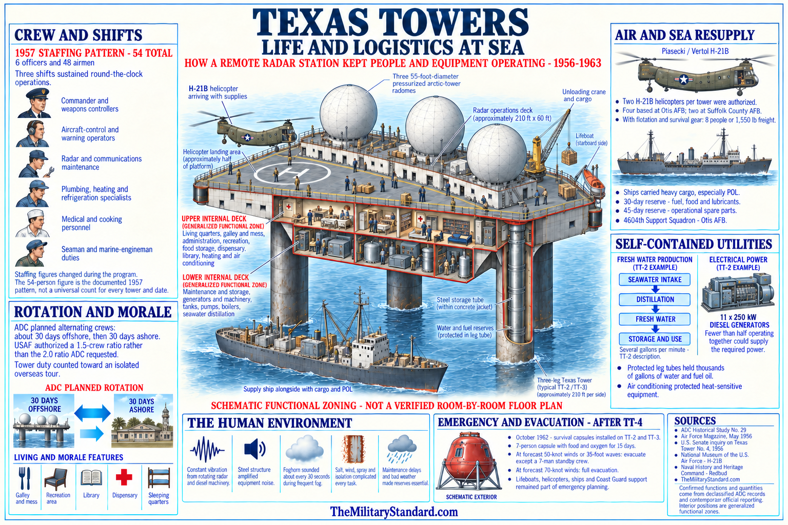
Ships would have carried diesel fuel, lubricants, heavy spares, food, and bulky equipment. Transfer at an exposed fixed platform depended on sea state, current, cranes, and safe station keeping. Later tower operations demonstrated how difficult routine resupply could become in fog, storms, and strong water movement. Those operational lessons illuminate the burden TT-1 would have imposed, but they are not events that happened at Cashes Ledge under the tower program.
The planned station would have been isolated in an environment already known for fishing, variable weather, and shallow hazards. Crews on completed towers experienced continuous vibration from antennas, generators, pumps, wind, and waves, with sounds transmitted through the steel legs. They worked long watches and depended on small recreation, mess, medical, and communications spaces. TT-1 has no veterans' roster or station newspaper because no crew ever occupied it.
Emergency planning would have had to address fire, medical evacuation, loss of power, failed water production, communications failure, aircraft accident, storm damage, and structural distress. The mature program later added or considered improved evacuation systems after the TT-4 disaster. TT-1 was canceled years before those lessons emerged. It should not be described as possessing escape capsules or later safety modifications.
Why TT-1 was not Built
The Air Force did not cancel TT-1 because Cashes Ledge ceased to exist or because the original radar gap was imaginary. It canceled the tower because the expected value of a fixed platform changed relative to cost and alternative coverage. As coastal Aircraft Control and Warning stations improved, planners anticipated greater offshore reach in the Cashes Ledge sector. The remaining gap no longer justified another major platform under the program's increasingly constrained economics.
Headquarters Air Force sought to reduce the five-tower program for economy while Air Defense Command initially resisted. The command still valued the warning geometry and wanted the planned arc. By late 1956, however, the promise of expanded coverage from coastal squadrons near Cashes Ledge and Browns Bank persuaded ADC to remove TT-1 and TT-5 from further consideration. The decision left TT-2, TT-3, and TT-4 as the completed system.
Cancellation occurred after TT-2 had demonstrated that a tower could be built but also that it was expensive to operate and difficult to support. By November 1955, contracts for TT-3 and TT-4 were already moving forward because they were tied to priority SAGE geography. TT-1 and TT-5 were the uncontracted ends of the arc and therefore the easiest projects to remove without wasting completed platforms. Program reduction was a sequencing decision as well as a technology decision.
The official Air Force civil-engineering history states that by the time TT-2 began operation in December 1955, planners anticipated expanded coastal radar coverage near Cashes Ledge and Browns Bank. ADC Historical Study No. 29 places final agreement to drop the two projects in late 1956. The difference reflects a developing recommendation followed by command-level cancellation. It is not necessary to force the entire process into one day when surviving public sources describe stages.
The later TT-4 collapse did not cause TT-1's cancellation. TT-1 had already been removed from consideration more than four years before the January 1961 disaster. Likewise, the 1963 ALRI transition did not directly cancel TT-1, though airborne early warning belonged to the broader family of alternatives that reduced dependence on fixed offshore structures. Accurate chronology prevents later program problems from being projected backward.
Result of Cancellation
No Texas Tower was fabricated for Cashes Ledge, no caissons were installed, no radomes were erected, and no radar equipment became operational there. No military housing, helipad, fuel system, power plant, pier, cable, navigation aid, or seabed foundation has been identified. The project therefore has no military closure date in the ordinary sense. Late 1956 marks cancellation of the planned installation, not deactivation of an operating station.
Because nothing was built, there was no excess declaration, property transfer, demolition, salvage operation, or wreck. There is also no known tower casualty list, veteran population, station emblem, call sign, or on-site unit lineage. TT-1 should not inherit TT-2's Foolhardy call sign, TT-3's Montauk relationship, or TT-4's casualty history. The project shares program context but not operational events.
The Air Force and Navy may have generated survey cores, engineering drawings, cost estimates, correspondence, and contract planning documents. Those records are the project's material legacy, even if most remain in archives rather than at Cashes Ledge. A complete administrative history would require Air Force, Navy Bureau of Yards and Docks, Corps of Engineers, Lincoln Laboratory, contractor, and command-history files. Public summaries establish the main sequence but not every staff action.
The cancellation also preserved Cashes Ledge from the direct physical effects of construction. No steel platform altered the skyline, no caissons penetrated the selected foundation point, and no long-term stream of fuel and waste supported a garrison. The site continued as a natural and working marine environment. That counterfactual consequence is historically important because completed towers left wrecks, debris, or dismantling records, while TT-1 did not.
Role in the Wider Military Network
TT-1 was designed to close the northern gap in a five-tower Atlantic warning arc. It would have overlapped coastal radars and extended their picture toward the center of the Gulf of Maine. Information from the tower would have moved through shore communications to command organizations that could compare it with reports from aircraft, ships, observers, and neighboring stations. Its purpose was network contribution rather than independent defense.
North Truro's 762d Squadron represents the most likely operational relationship identified in later site indexes. The coastal station already participated in the Cape Cod experimental system, entered the permanent radar network, supported SAGE, and operated TT-2 as an offshore annex. A Cashes Ledge annex would have extended that operational model northward. The absence of a confirmed activated flight means this remains intended organization, not completed lineage.
Navy radar picket ships and Air Force airborne early-warning aircraft provided mobile seaward coverage. They could reposition and address some low-altitude gaps, but required recurring patrol effort. A fixed TT-1 promised continuous presence and heavy equipment, while accepting the risks of an immobile structure. Program cancellation reflects a judgment that the northern sector could be covered adequately without paying that fixed-platform cost.
Pease, Grenier, Otis, and other New England bases formed the potential aviation and logistics environment. Fighter-interceptor units at shore bases would have acted on tracks; support units would have moved people and supplies; sector command centers would have evaluated the air picture. TT-1 would not have replaced those installations. It would have increased the time and geographic depth available to them.
SAGE made sensor location and communications reliability more valuable while reducing the need for all control decisions to occur locally. A completed TT-1 could have sent digitized radar information to a direction center, where computers and controllers correlated multiple sources. The tower was canceled before any SAGE integration, data-circuit activation, or testing at Cashes Ledge. Its planned role should not be described as an operational SAGE site.
Current Cashes Ledge Status
Cashes Ledge today is a natural submarine ridge and regulated marine habitat, not a former built military property. NOAA Fisheries identifies both a broader Cashes Ledge Closure Area and a smaller Habitat Management Area. The habitat area is closed year-round to bottom-tending mobile gear under current fisheries rules. Those boundaries are conservation and fisheries-management tools, not the boundary of TT-1.
The ridge supports a notable kelp-forest ecosystem and complex rocky habitat. Scientific literature describes Ammen Rock and other sampling locations as productive offshore sites with persistent ecological patterns. This natural importance helps explain why modern references to Cashes Ledge may contain detailed maps and coordinates even though military records remain sparse. The ecological data must not be mistaken for evidence of a Texas Tower footprint.
No charted TT-1 wreck or obstruction exists because no tower was placed. NOAA navigation products may show reefs, ridges, rocks, buoys, fishing areas, or scientific stations in the region, but none should be relabeled as military remains without evidence. The representative planned coordinate is a historical research aid only. Mariners must use current official charts, notices, and regulations.
No FUDS or Defense Environmental Restoration Program project specific to TT-1 was located. Since the military did not construct, fuel, occupy, or demolish a station at the site, there is no factual basis to infer tower-related contamination. Survey work may have temporarily disturbed small seabed locations, but no public record reviewed documents a hazardous release, abandoned equipment, or cleanup requirement. Environmental discussion therefore centers on absence of a built military footprint and present marine management.
Chronology
- 1946 through 1951 Air Defense Command and related organizations examined methods for extending radar coverage seaward beyond coastal line-of-sight limits.
- 1948 through 1952 Lashup, permanent-system, picket-ship, airborne-warning, and experimental radar projects established the layered context for an offshore fixed-station proposal.
- August 1, 1952 MIT Lincoln Laboratory outlined the fixed offshore radar-platform concept later called the Texas Towers.
- 1952 through 1953 Planners evaluated shallow banks and ledges that could support fixed platforms along northeastern bomber approaches.
- Autumn 1953 The Secretary of the Air Force authorized a five-tower construction program on Air Defense Command's recommendation.
- January 11, 1954 Later site histories identify this as the specific approval date for Texas Tower No. 1; the underlying memorandum requires archival verification.
- March 1954 The Air Force authorized the Navy Bureau of Yards and Docks to prepare contract plans and specifications.
- March 1954 The proposed Cashes Ledge installation received project designation TT-1.
- March 1954 The other proposed sites received designations TT-2 through TT-5.
- July 1954 The Navy contracted with the DeLong and Raymond joint venture for offshore core drilling.
- Summer 1954 Engineering firms and government agencies conducted surveys for the five proposed locations, including Cashes Ledge.
- October 1954 The feasibility report for the candidate tower sites was completed.
- December 1954 The Navy awarded Bethlehem Steel the contract for the first platform.
- December 1954 Air Defense Command chose TT-2 at Georges Shoal, not TT-1, as the prototype because of shallow water and its relationship to the first semi-automatic defense area.
- Spring 1955 Bethlehem Steel completed the main TT-2 platform at Quincy, Massachusetts while TT-1 remained a future project.
- May 20, 1955 The TT-2 platform was launched, providing the first physical test of the design family intended for the program.
- July 1955 TT-2 was towed to Georges Shoal and erected, producing engineering and cost experience relevant to decisions about TT-1.
- November 1955 Bids for TT-3 and TT-4 were accepted while TT-1 and TT-5 remained uncontracted end points of the planned chain.
- December 2, 1955 Air Defense Command accepted beneficial occupancy of TT-2.
- December 1955 Official Air Force history states that expanded coastal radar coverage was already anticipated near Cashes Ledge and Browns Bank.
- Early 1956 Air Defense Command continued evaluating the remaining five-site program against cost, construction, coverage, and support requirements.
- March 12, 1956 Air Defense Command issued a Texas Towers logistic support plan for the developing operational system.
- May 7, 1956 TT-2 achieved limited operational readiness, providing practical evidence about offshore radar operation and support.
- August 1956 TT-3 was launched, towed, and erected at Nantucket Shoal.
- September 28, 1956 The 4604th Aircraft Control and Warning Squadron (Texas Towers) activated at Otis Air Force Base.
- October 8, 1956 The 4604th assumed specialized support responsibility for the operating tower system.
- Late 1956 Headquarters Air Force sought economy by eliminating TT-1 and TT-5, while Air Defense Command initially resisted.
- Late 1956 Air Defense Command agreed that anticipated coastal radar coverage permitted removal of TT-1 and TT-5 from further consideration.
- Late 1956 Texas Tower No. 1 was canceled before platform fabrication, offshore emplacement, equipment installation, or activation.
- November 29, 1956 Air Defense Command accepted beneficial occupancy of TT-3, leaving three physical towers in the reduced program.
- December 31, 1956 The 4604th was redesignated the 4604th Support Squadron (Texas Towers).
- 1957 Construction and emplacement of TT-4 proceeded while no TT-1 construction occurred.
- November 1957 TT-4 reached Air Force beneficial occupancy, completing the three-tower physical system.
- 1958 TT-2 and TT-3 entered full manual operations; TT-1 remained canceled.
- September 1958 TT-2 became operational in SAGE, demonstrating the automated role once anticipated for the tower chain.
- April 1960 TT-3 and TT-4 reached documented SAGE operation, while the Cashes Ledge sector continued without TT-1.
- January 15, 1961 TT-4 collapsed with twenty-eight military and civilian personnel aboard; this disaster occurred years after TT-1 cancellation and did not cause it.
- January 15, 1963 TT-2 was decommissioned as Air Defense Command shifted from fixed towers toward other seaward-input methods.
- March 25, 1963 TT-3 was decommissioned, ending operation of the completed Texas Tower system.
- September 1963 TT-2 was demolished with explosives; no comparable action occurred at Cashes Ledge because TT-1 had never been built.
- March 1965 Air Defense Command issued Historical Study No. 29, preserving the principal official narrative of the five-site program and TT-1 cancellation.
- 1997 The Air Force-sponsored Searching the Skies history placed the Texas Towers within the national Cold War radar network.
- 1998 The Cashes Ledge Closure Area became part of modern fisheries protection, a use unrelated to military cleanup.
- 2016 Fisheries management established or refined the Cashes Ledge Habitat Management Area with explicit geographic boundaries.
- 2017 Published scientific research documented persistent kelp-forest community patterns at Cashes Ledge and Ammen Rock.
- 2026 NOAA Fisheries continued year-round restrictions on bottom-tending mobile gear within the Cashes Ledge Habitat Management Area.
Information sources (35)
- PDFADC Historical Study No. 10, Seaward Extension of Radar, 1946-1956
Aerospace Defense Command. Official source for the offshore warning requirement, March 1954 project designations, Navy role, core drilling, surveys, feasibility report, and selection of TT-2 as prototype.
- PDFADC Historical Study No. 29, A History of Texas Towers in Air Defense, 1952-1964
Aerospace Defense Command, March 1965. Core official source for the five-site program, Cashes Ledge designation, engineering, economics, command debate, and late-1956 cancellation.
- PDFADC Historical Data, 1946-1973. Aerospace Defense Command (17.67 MB)
Authoritative source for station, unit, site-designation, radar-equipment, and completed Texas Tower program data.
- PDFEstablishing Independence. Air Force History and Museums Program
Official history for the Lincoln Laboratory recommendation, five sites, authorization, engineering and construction plan, warning objective, completed towers, and cancellation of TT-1 and TT-5.
- PDFLeading the Way: The History of Air Force Civil Engineers. Department of the Air Force civil-engineering history
Official construction narrative for the Texas Tower concept, TT-2 prototype, and cancellation of Cashes Ledge and Browns Bank projects.
- WEBSearching the Skies: The Legacy of the United States Cold War Defense Radar Program. David F. Winkler, prepared for Headquarters Air Combat Command, 1997
Official Air Force-sponsored network and preservation context.
- PDFA Handbook of Aerospace Defense Organization, 1946-1980. Office of History, Aerospace Defense Center
Official organizational reference for Air Defense Command, sectors, wings, and radar squadrons related to the program.
- WEBAir Defense Command fact sheet. Department of the Air Force History and Museums Program
Official command mission and continental-defense context.
- WEBSAGE: Semi-Automatic Ground Environment Air Defense System. MIT Lincoln Laboratory
Official laboratory history of the automated network for which completed towers were adapted and TT-1 was originally relevant.
- WEBHistorical Review of North American Aerospace Defense, 1946-1970. NORAD historical study
Official context for seaward extension, the three completed towers, and the continental warning network.
- WEBAir Defense Command and Antibomber Defense, 1946-1972, ADC Historical Study No. 39
Official source for the changing antibomber network, tower closure, and airborne alternatives.
- PDFNORAD and CONAD History, 1956-1957
Official command record for seaward radar, communications, completed-tower readiness, and the developing network during TT-1 cancellation.
- PDFA Chronology of Air Defense, 1914-1972, ADC Historical Study No. 19
Official chronology for the later completed-tower and airborne-input sequence.
- WEBContinental Air Defense historical study, volume 2. U.S. Army Center of Military History
Official joint-defense context for radar warning, completed tower occupancy, and limited ground-controlled-interception roles.
- PDF762 Radar Squadron (SAGE) history
Unit-history compilation for North Truro, TT-2 parentage, radar equipment, SAGE, and the operational model later indexes associate with TT-1.
- WEBTexas Towers program index. Radomes, Inc
Secondary preservation and research route distinguishing unbuilt TT-1 and TT-5 from completed TT-2, TT-3, and TT-4.
- WEBRadar Time Lines. Radomes, Inc
Secondary equipment and station timeline showing zero operational years for TT-1 and TT-5.
- WEBNew Hampshire Air Defense Radar Stations. Radomes, Inc
Secondary catalog placing TT-1 at Cashes Ledge and associating the proposed site with the 762d Squadron index.
- WEBCashes Ledge and Fippennies Ledge Habitat Management Areas. NOAA Fisheries
Current official boundaries, fishing restrictions, and management status.
- WEBCashes Ledge Groundfish Closure Area map. NOAA Fisheries
Official current map landing page for the broader closure area.
- PDFPersistence of Regional-Scale Patterns in Kelp Forest Communities
NOAA repository copy of peer-reviewed research for Cashes Ledge distance, ridge length, Ammen Rock coordinates, ecosystem, and map.
- PDFGulf of Maine regional map and marine research publication. NOAA repository
Official visual geographic context showing Cashes Ledge, Browns Bank, Georges Bank, and surrounding basins.
- PDFU.S. Coast Pilot 1. NOAA Office of Coast Survey
Current official navigation description and research route for Cashes Ledge and Gulf of Maine hazards.
- PDFU.S. Coast Pilot 1 Index. NOAA Office of Coast Survey
Current official index locating the Cashes Ledge description within the Coast Pilot.
- WEBHistorical Map and Chart Collection. NOAA Office of Coast Survey
Official route for period and current chart research at Cashes Ledge.
- WEBHydrographic Survey Data. NOAA Office of Coast Survey
Official route for seabed survey records and source data relevant to the candidate area.
- WEBNOAA Bathymetric Data Viewer and Interagency Elevation Inventory
Official route for modern bathymetry and hydrographic survey coverage.
- PDFOmnibus Essential Fish Habitat Amendment final environmental impact statement, volume 3
New England Fishery Management Council and NOAA material for Cashes Ledge management alternatives and mapped boundaries.
- PDFFederal Register, September 5, 2000
Official regulation and coordinate record for the Cashes Ledge Closure Area.
- WEBInquiry into the Collapse of Texas Tower No. 4. U.S. Senate Committee on Armed Services, 1961
Official engineering and program-responsibility record used for comparison while preserving that TT-1 was canceled earlier.
- WEBInquiry into the Collapse of Texas Tower No. 4, digitized hearing
Internet Archive copy of the official Senate record with drawings and exhibits for the common tower design.
- PDFGuide to Air Force Historical Literature, 1943-1983. Department of the Air Force History and Museums Program
Official bibliography for ADC Historical Studies Nos. 10 and 29 and related records.
- PDFU.S. Air Force Bases history. Air Force History and Museums Program
Official contextual reference for the completed artificial offshore platforms and continental-defense network.
- WEBTexas Towers overview. Air & Space Forces Magazine
Air Force Association summary of the proposed and completed system and its operational purpose.
- WEBGlory. Air & Space Forces Magazine, September 1958
Contemporary account of the completed tower system, logistics, radar mission, and life that TT-1 would have shared had it been built.