
Texas Tower No. 5 / Browns Bank Planned Radar Station, New Hampshire
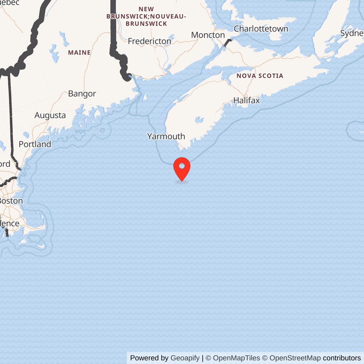
Longitude: -65.616667
Site Number: TT-5
Official Base Website: Browns Bank
Current Role: Natural Browns Bank submarine bank, fisheries area, and marine habitat south of Nova Scotia in the Canadian offshore environment. No Air Force platform, foundation, radar, wreck, military debris field, property parcel, or active military use resulted from TT-5. Current fisheries and conservation measures are Canadian marine management, not reuse of a former defense installation.
Texas Tower No. 5 was an authorized but unbuilt United States Air Force offshore radar project proposed for Browns Bank south of Nova Scotia. Air Defense Command intended TT-5 to form the northeastern end of an original five-platform chain designed to push aircraft warning far beyond the Atlantic coast. The project reached formal program authorization, site designation, marine survey, core-drilling, feasibility, and engineering stages. It was canceled in late 1956 before platform fabrication, emplacement, military occupancy, radar activation, or assignment of an operating crew.
TT-5 has a real history even though it left no physical station. Its selection records how American air-defense planners tried to close a northern Atlantic radar gap during the early atomic-bomber era. Its cancellation records the competing effects of cost, improving coastal surveillance, developing airborne warning, and rapid evolution toward the Semi-Automatic Ground Environment. The project belongs in the installation inventory as a distinct planned facility, but every description must distinguish intended features from accomplished events.
The available primary record establishes the five-tower program more securely than it establishes the final details of TT-5. Air Force histories identify Browns Bank as the fifth project and document common engineering work for all five sites. Later compilations give a representative point, an approximate depth, a January 1954 approval date, a possible 654th squadron relationship, and proposed Pease Air Force Base support. Those later details are useful leads, but they are not equivalent to an activated unit order, an accepted construction drawing, or a surveyed foundation coordinate.
Modern Browns Bank is a natural submarine bank in Canadian offshore waters, not an abandoned American military property. Fisheries and Oceans Canada describes it as part of the western Nova Scotia banks and includes portions of the area in fisheries, habitat, and conservation planning. No tower, caisson, radar, power plant, barracks, helicopter deck, wreck, debris field, military contamination site, or transferred federal parcel resulted from TT-5. Current restrictions and scientific interest concern the marine ecosystem and fisheries rather than a former defense installation.
Installation Identity, Name, and Scope
Texas Tower No. 5, Texas Tower 5, TT-5, Browns Bank Texas Tower, and Browns Bank Planned Radar Station refer to the same canceled project. The number placed the site at the northeastern end of the proposed offshore sequence. It did not mean that five towers were completed, nor did it mark a fifth operating squadron. Only TT-2, TT-3, and TT-4 became physical installations, while TT-1 and TT-5 remained unbuilt.
The project must not be merged with Pease Air Force Base, Grenier Air Force Base, the 654th Aircraft Control and Warning Squadron, Canadian Pinetree Line stations, Canadian maritime-surveillance systems, or any present fisheries-management area. Those installations and organizations had their own legal identity, property, personnel, and operational histories. TT-5 was a separate proposed American offshore sensor position. Possible mainland support and reporting relationships did not turn it into an annex that physically existed at a shore base.
Authorization also must not be confused with activation. The Secretary of the Air Force approved a five-tower construction program in autumn 1953, and later summaries associate January 11, 1954 with approval of TT-5. The Air Force then used the Navy Bureau of Yards and Docks as its design and construction agent, and the five candidate sites entered a common survey program. No evidence reviewed shows that a TT-5 platform contract was awarded, steel was cut for Browns Bank, a caisson was launched, or the Air Force accepted beneficial occupancy.
The history catalogs TT-5 under New Hampshire because the American planning record associates the project with northeastern New England support geography and because the registry uses United States state codes. That is an indexing convention, not a claim that Browns Bank lay within New Hampshire, another state, or uncontested United States waters. The proposed point is south of Nova Scotia and east of the later Canada-United States maritime boundary. Its legal and diplomatic setting therefore differed from an ordinary domestic Air Force reservation.
Location, Geography, and Representative Coordinate
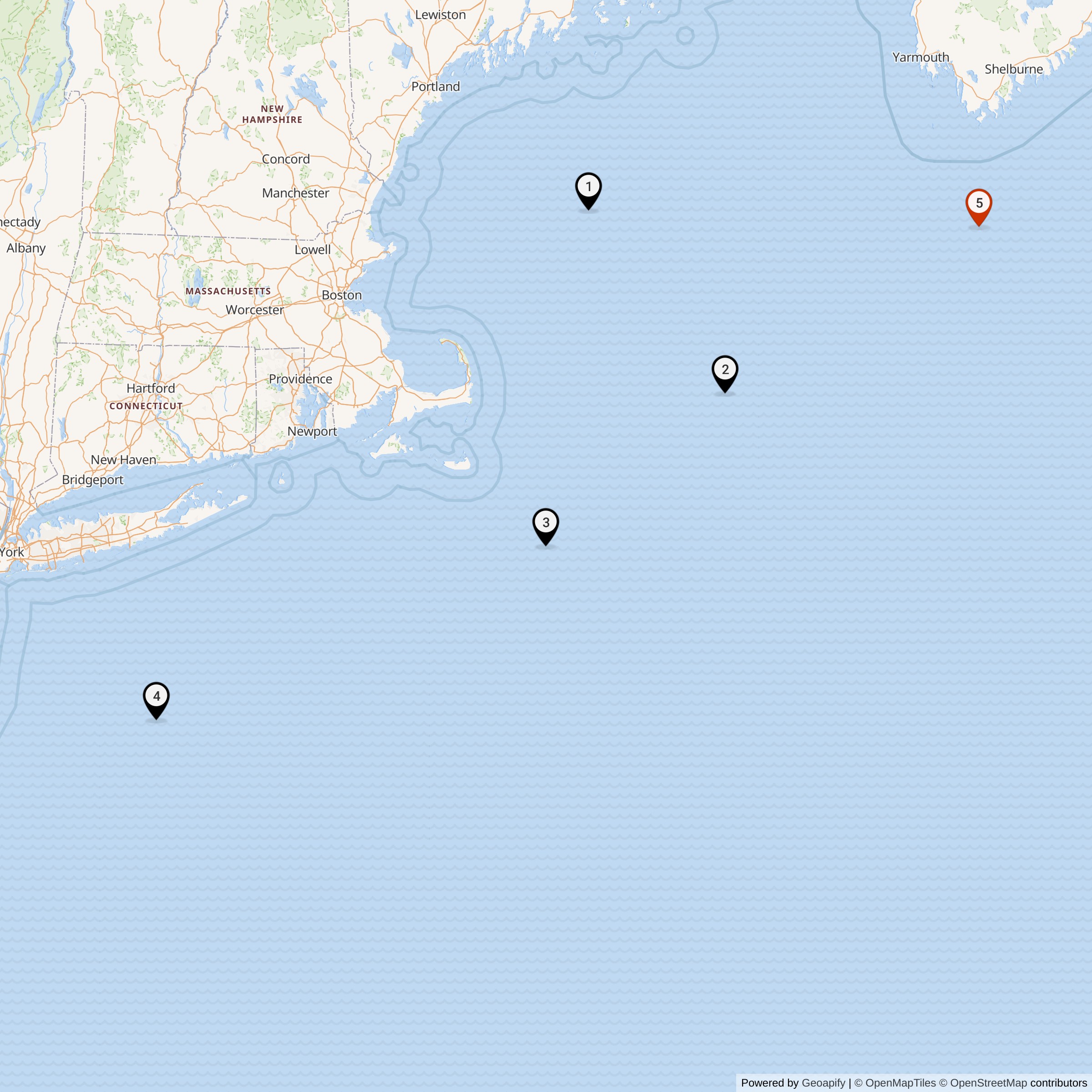
Browns Bank is an extensive submarine bank at the western end of the Nova Scotia banks. Current Canadian sailing directions place it west-southwest of Baccaro Bank and separate it from Georges Bank by the deep Fundian Channel. The bank contains broad shoal areas, channels, slopes, and varied bottom conditions rather than one isolated pinnacle. Its location offered a possible northeastern radar outpost while exposing any structure to severe open-ocean weather and distant logistics.
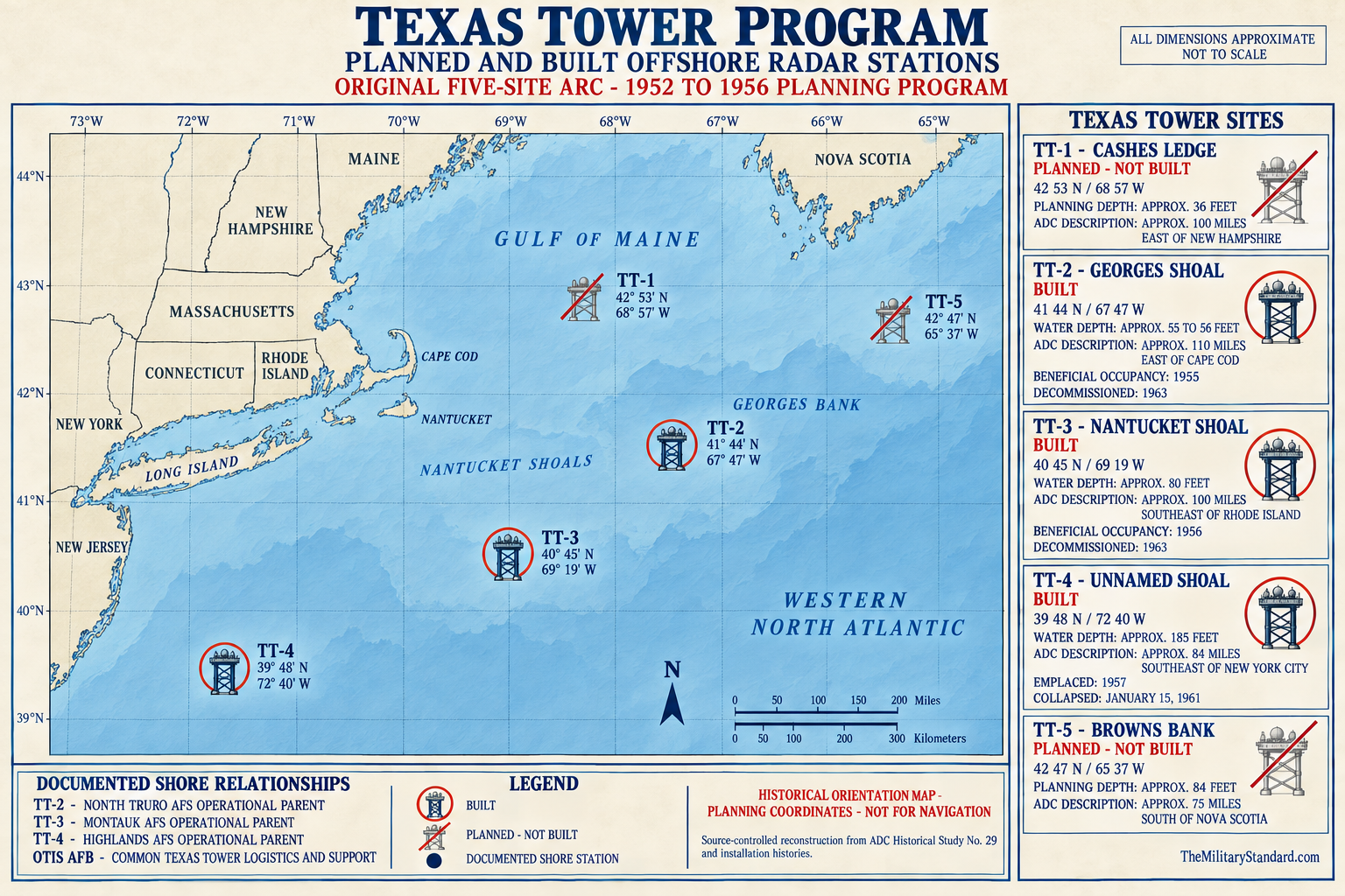
Later Texas Tower compilations place the TT-5 proposal near 42 degrees 47 minutes north latitude, 65 degrees 37 minutes west longitude. Converted to decimal form, the representative point used here is 42.783333, -65.616667. The available Air Force project histories do not identify that coordinate as a final caisson center, construction stake, lease corner, or accepted engineering datum. It therefore labels the historical proposal only and must not be used for navigation, fishing, diving, jurisdiction, or seabed work.
Modern Canadian sailing directions identify a sandy rise on Browns Bank with a least depth of 16 fathoms, or 29 meters, near 42 degrees 49 minutes north and 66 degrees 13 minutes west. That natural-feature point lies roughly 27 nautical miles west of the later TT-5 project coordinate. The separation demonstrates why neither coordinate should silently substitute for the other. The project point may reflect a particular candidate location, a later plotting convention, or a planning revision that cannot be reconstructed from the surviving public record.
Secondary Texas Tower accounts state that the planned position lay about 35 nautical miles south of Nova Scotia in approximately 84 feet of water. The distance is broadly consistent with a Browns Bank location, but the reported depth conflicts with or at least differs from the modern sailing-direction description of the bank's least surveyed depth. Water depth changes across the bank, and different chart datums or candidate points can yield different figures. The 84-foot figure is retained only as a qualified planning claim pending recovery of site-specific 1954 core and survey records.
The geology mattered directly to the proposed platform. A fixed tower required sediment and underlying material able to accept driven or seated tubular caissons and resist storm, current, and cyclic wave loading. Modern Geological Survey of Canada work describes coarse-grained deposits across Browns Bank, with sand in some shallower areas and broader deposits elsewhere. Those regional findings cannot reconstruct the 1954 borings, but they explain why Air Force and Navy planners required core drilling before committing to a foundation design.
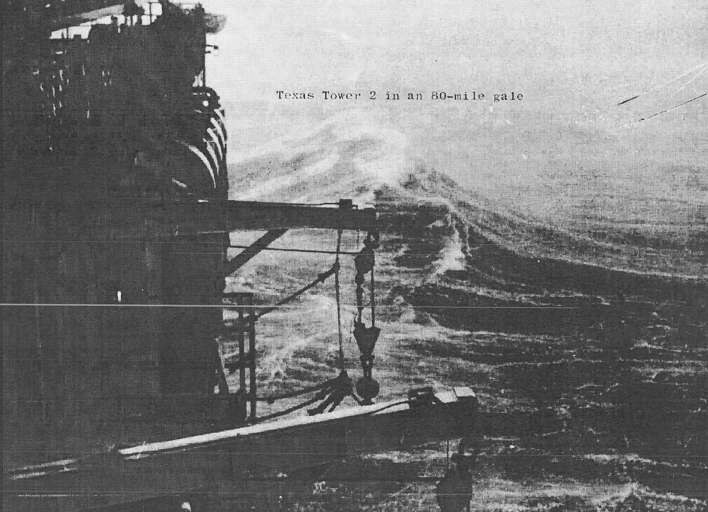
The marine environment also complicated construction and operations. Fog, high winds, icing, corrosion, strong currents, wave action, and seasonal storms could stop helicopter or ship access and increase structural fatigue. A platform at the northeastern end of the chain would have been more isolated from the Massachusetts support system than the completed towers. These conditions were planning risks only at TT-5 because no crew ever experienced them there, but they were legitimate reasons for demanding redundant systems and conservative logistics.
Strategic Requirement
The Soviet long-range bomber threat drove the seaward-extension program. Coastal radar stations could detect high aircraft at substantial distance, but the curvature of the earth limited line of sight against bombers approaching at lower altitude. Placing a powerful radar on Browns Bank promised to move the detection horizon eastward and northeastward. That extra warning time could help identify tracks, alert interceptor units, and organize a defense before aircraft reached the New England and Canadian coastlines.
TT-5 was never intended to fight an air battle independently. It would have contributed surveillance data to a layered system that included shore-based Aircraft Control and Warning stations, fighter-interceptor bases, command centers, identification procedures, Navy radar picket ships, airborne early-warning aircraft, and communications networks. The platform would have supplied earlier range, bearing, altitude, and identification information. Commanders on shore would have combined that information with other sensors and directed interceptor operations.
MIT Lincoln Laboratory developed the fixed-platform idea while working on the Cape Cod System and the concepts that evolved into SAGE. On August 1, 1952, the laboratory proposed adapting offshore oil-platform technology to support heavy land-type radar antennas on shallow Atlantic banks. A fixed installation could remain continuously on station and avoid the antenna motion of a ship. It also transferred the problem from fuel endurance and ship stability to expensive construction, structural survival, and support of a small community at sea.
The five proposed locations formed a geographic concept rather than five interchangeable copies. TT-1 at Cashes Ledge covered a northern Gulf of Maine approach, TT-2 at Georges Shoal became the prototype, TT-3 served Nantucket Shoal, TT-4 covered approaches off New Jersey, and TT-5 extended the line toward Nova Scotia. Browns Bank was therefore the northeastern cap of the original array. Its location potentially complemented both American coastal stations and the broader Canadian-American air-defense network.
Program advocates estimated that the tower chain could extend continuous East Coast radar coverage hundreds of miles seaward and add about thirty minutes or more of warning in favorable cases. Those figures described the combined concept, not guaranteed TT-5 performance. Actual detection would have depended on target altitude, radar cross-section, atmospheric propagation, antenna height, equipment serviceability, operator recognition, communications, and overlap with other sensors. No operational data exist for TT-5 because it never transmitted a track.
Program Authorization and Early Development
Air Defense Command and related organizations studied seaward radar extension through the late 1940s and early 1950s. Radar picket ships, airborne warning aircraft, coastal stations, and experimental semi-automatic systems offered partial solutions, but each had limits. The fixed-platform proposal promised persistence and room for large radar equipment. It entered a defense environment in which planners were expanding coverage rapidly while technologies, threats, and budgets changed almost as quickly.
The Secretary of the Air Force authorized five Texas Towers in autumn 1953 after Air Defense Command endorsed the concept. This decision gave Browns Bank a place in an approved construction program rather than an informal map study. Later site summaries cite January 11, 1954 as approval of Tower No. 5. The most careful interpretation is that the autumn decision authorized the overall five-site program and the January date may represent a site-specific or administrative milestone whose original document remains unlocated.
In March 1954 the Air Force authorized the Navy Bureau of Yards and Docks to prepare contract plans and specifications. The Air Force assigned TT-1 to Cashes Ledge, TT-2 to Georges Shoal, TT-3 to Nantucket Shoal, TT-4 to Unnamed Shoal, and TT-5 to Browns Bank. The Navy acted as design and construction agent because it possessed marine-engineering and contracting experience. Air Force technical organizations retained responsibility for the operational requirement and radar mission.
The Navy contracted with the DeLong Corporation and Raymond Concrete Pile Company joint venture in July 1954 for core drilling at the proposed locations. Engineering firms and government organizations conducted surveys during the summer, and a feasibility report followed in October. These actions show that TT-5 advanced beyond a name on a planning chart. They do not show that the Browns Bank design reached final construction drawings, because the public history does not reproduce a TT-5 boring log, foundation recommendation, or approved site plan.
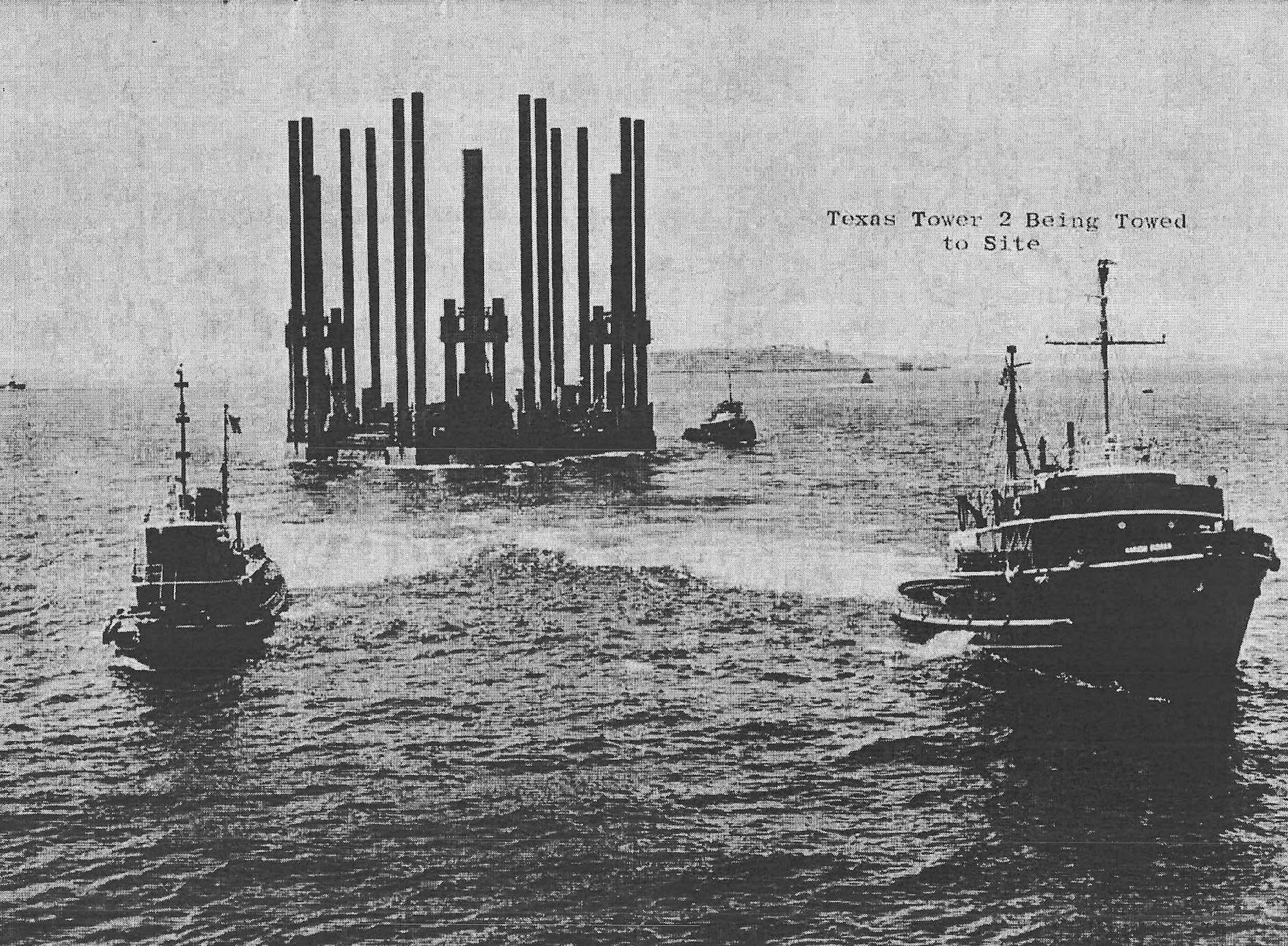
In December 1954 the Navy awarded Bethlehem Steel the contract for the first platform. Air Defense Command selected TT-2 at Georges Shoal as the prototype because the water was relatively shallow and the site was positioned near the first semi-automatic air-defense area. Choosing TT-2 deferred TT-5 while engineers and commanders learned from the initial structure. The decision allowed the program to test fabrication, launching, towing, erection, equipment installation, and offshore living before contracting for every site.
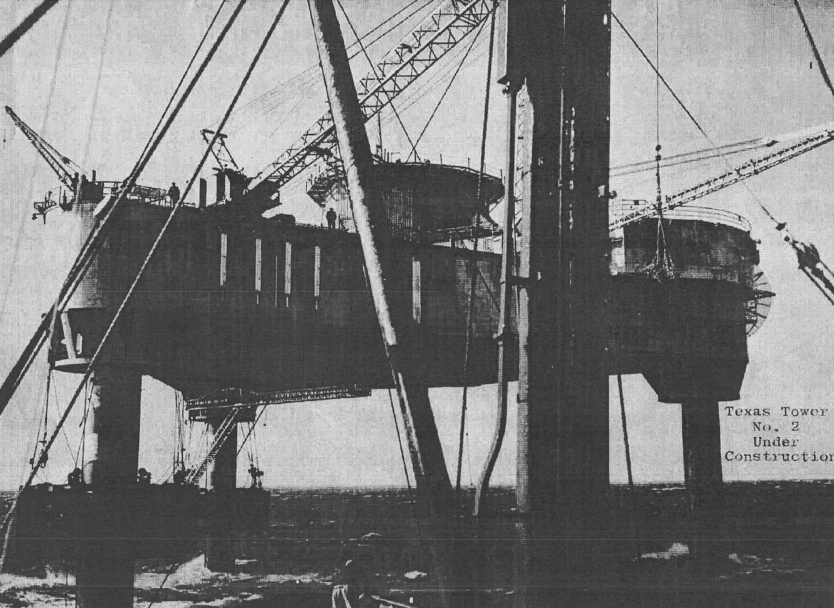
TT-3 and TT-4 later received contracts, but TT-1 and TT-5 remained uncontracted. That sequence is decisive for TT-5's physical history. Common plans, survey work, cost estimates, and support concepts existed, but there was no Browns Bank platform to finish, launch, tow, jack up, equip, or accept. The three completed towers can illustrate intended design features, but their construction events must never be copied into the TT-5 chronology.
Intended Design and Facilities
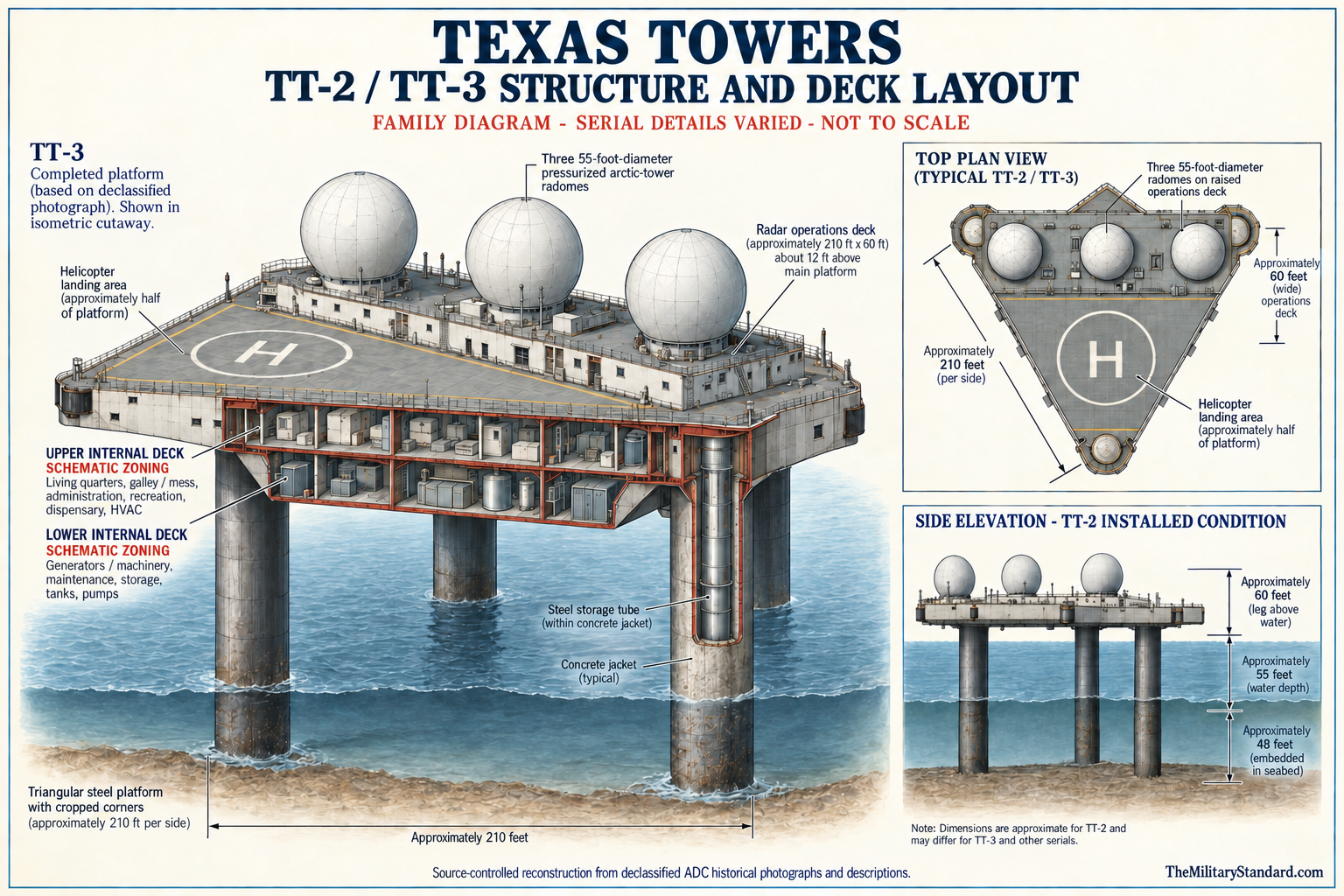
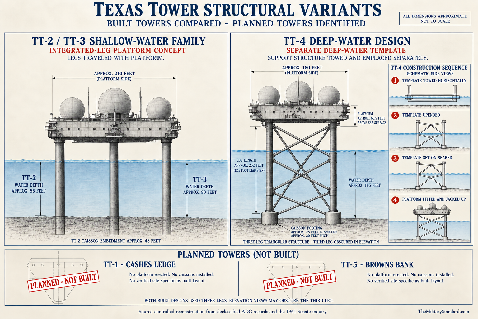
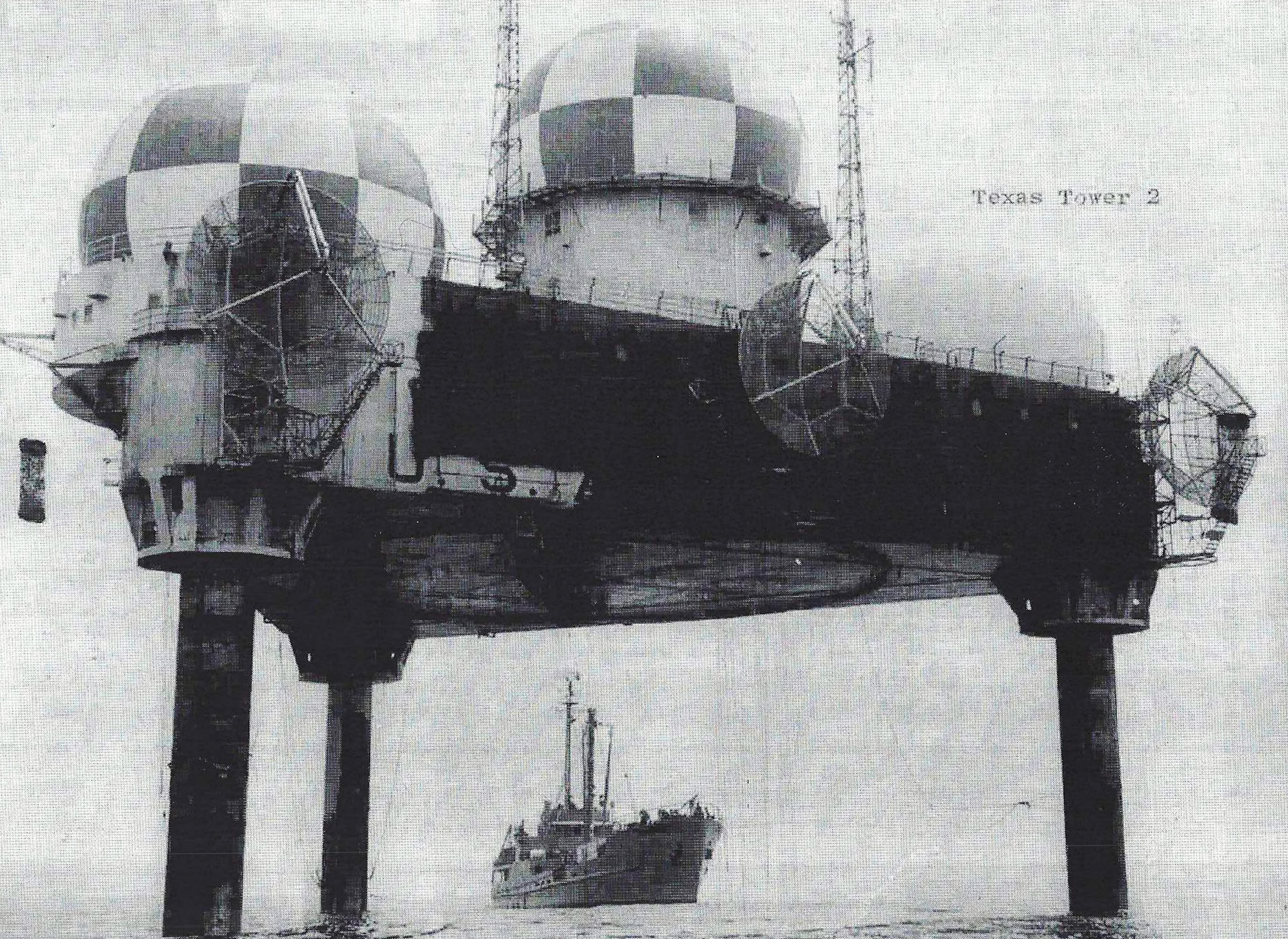
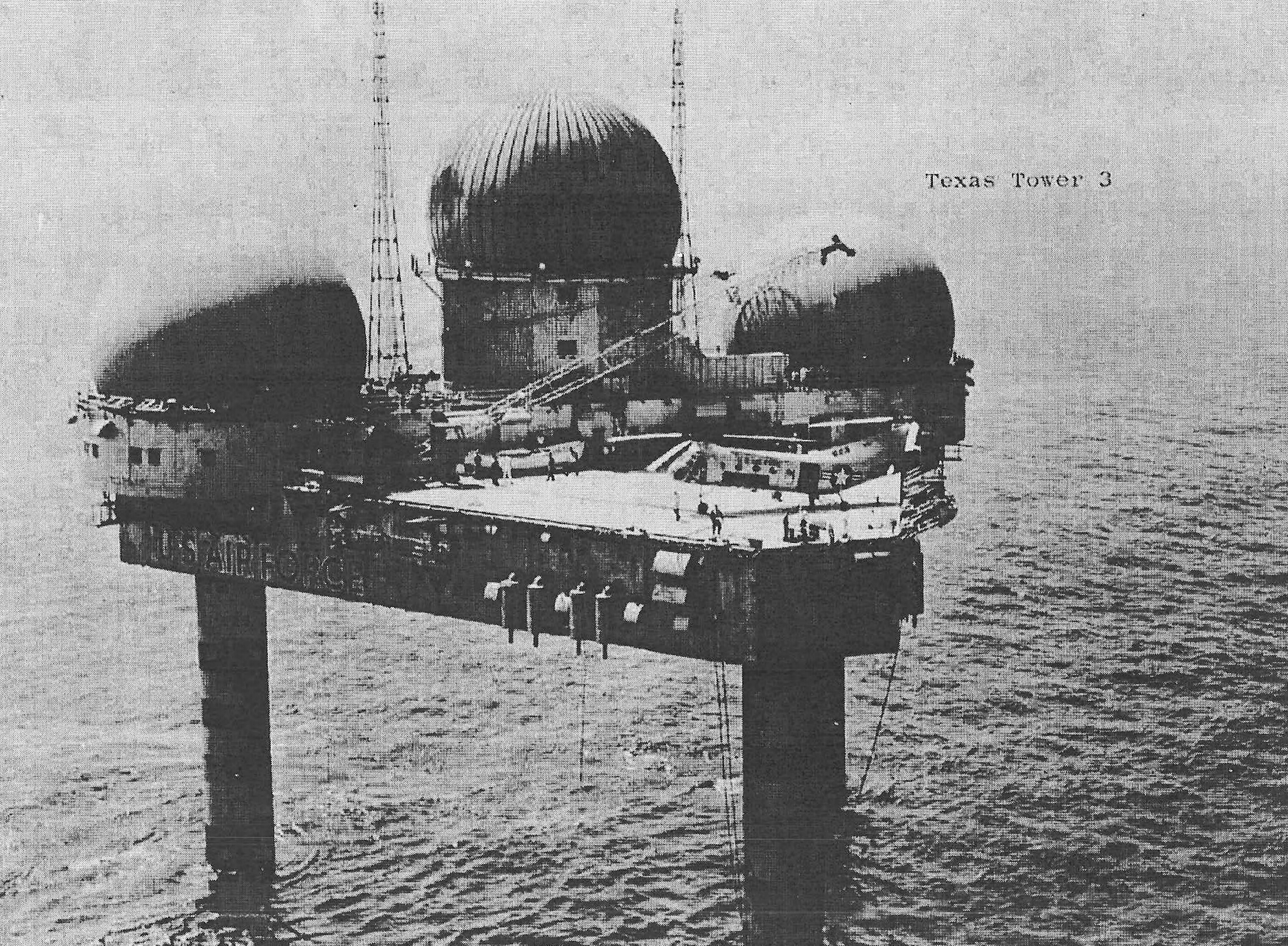
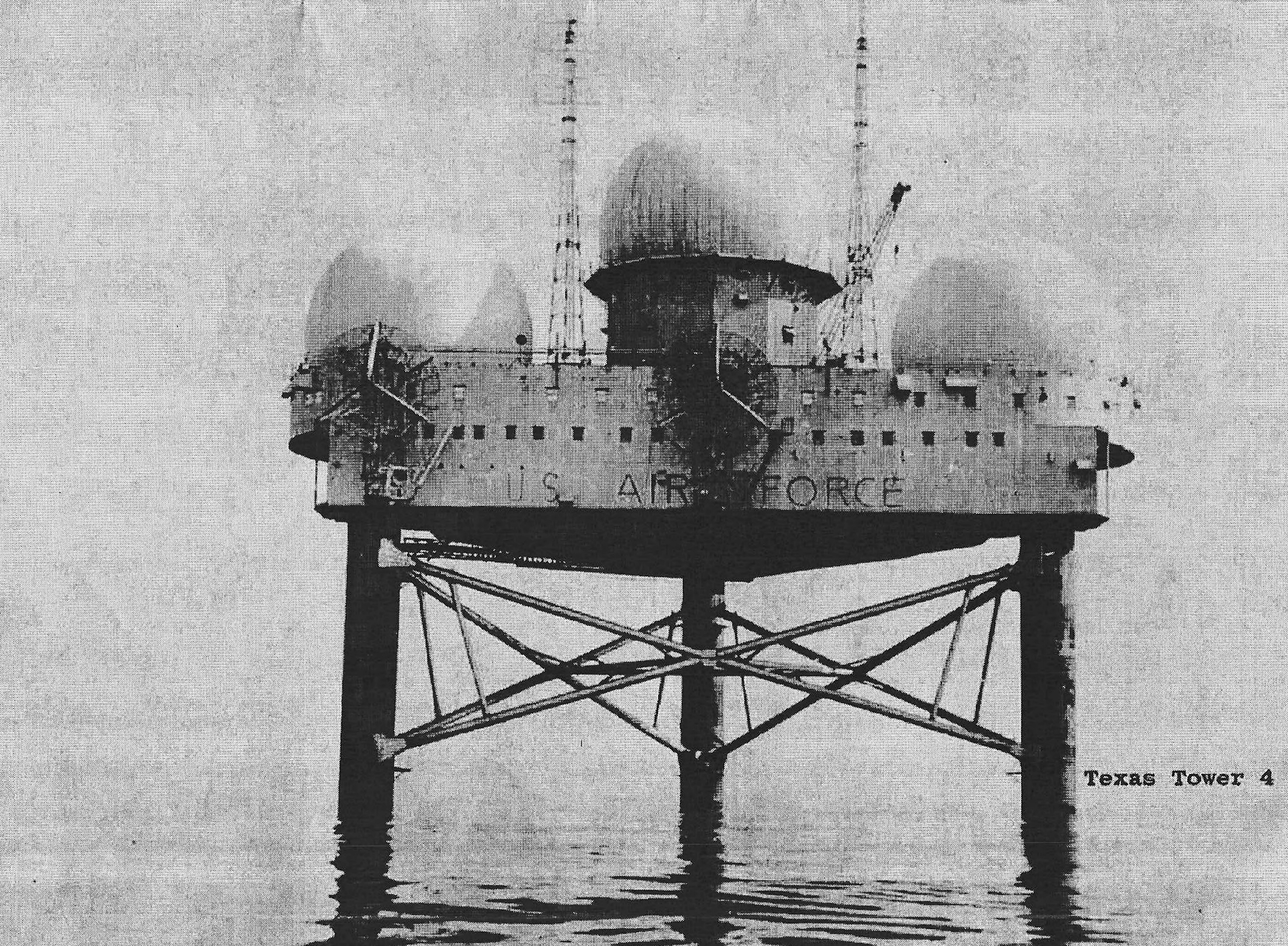
The completed tower family provides the best available model for what TT-5 was meant to become. The prototype used a cropped triangular steel platform roughly 210 feet on a side, with about one-half acre of upper surface and an enclosed body approximately 20 feet deep. Three large tubular legs supported the structure above the sea. Final TT-5 dimensions could have changed for Browns Bank depth and soil, so these measurements describe the common program concept rather than an as-built Browns Bank installation.
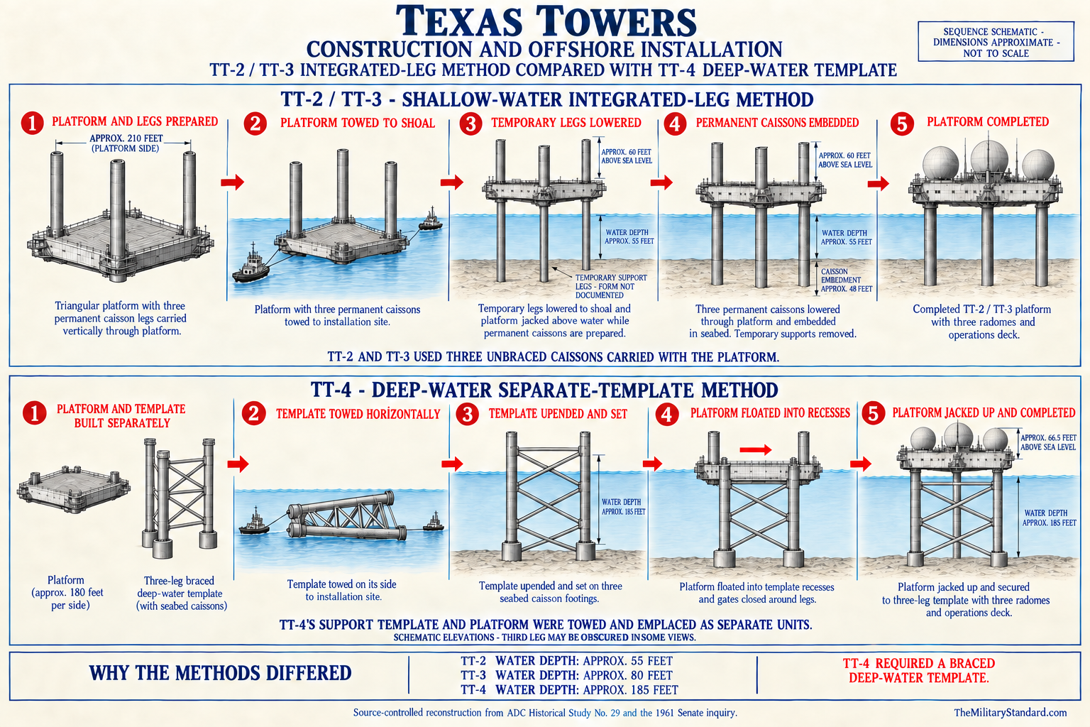
The intended platform combined radar operations, machinery, storage, aviation, and living functions. Lower spaces in the built design contained pumps, tanks, generators, workshops, spare parts, and utility systems. Living spaces included bunks, a galley and mess, administration, recreation, medical capability, and food storage. An elevated operations area housed displays, communications, and radar-processing equipment, while an exposed deck supported helicopter operations and marine transfer work.
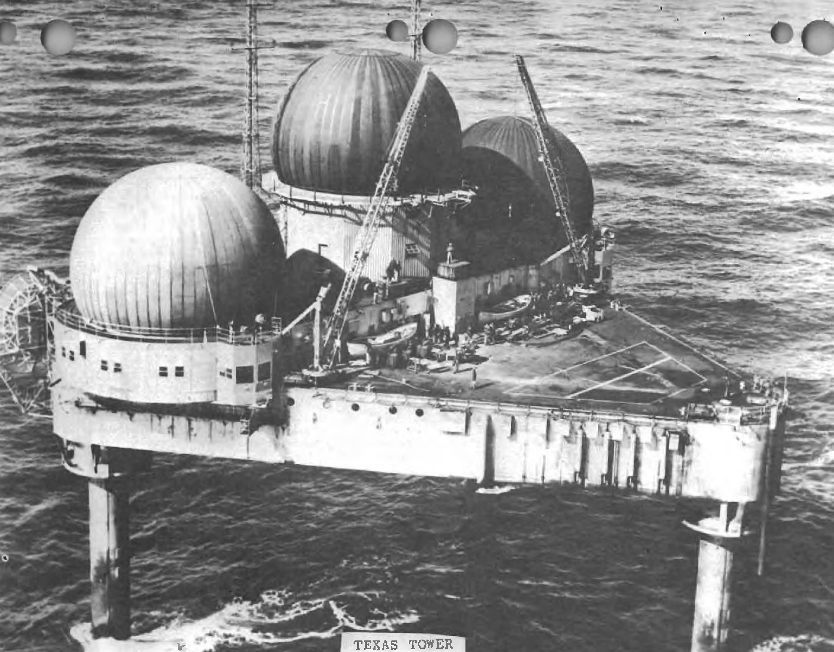
Three prominent radomes defined the appearance of the completed towers. The largest protected the long-range search radar, and two others covered height-finder antennas. TT-5 was expected to follow that functional arrangement because it needed bearing, range, altitude, identification, and communication capabilities. No released site-specific equipment authorization proves exactly which production radar variants would have been installed after a later construction date, so the common AN/FPS-3 and AN/FPS-6 family is an intended program analogy rather than an activated TT-5 inventory.
The legs of a completed platform performed more than structural work. They enclosed or supported fuel, water, intake, sanitary, and utility functions and transferred environmental loads into the seabed. A Browns Bank tower in a reported 84 feet of water would have required site-specific leg length, penetration, bracing, and installation methods.
Independent electrical generation was essential. Multiple diesel generators on the built towers provided redundancy for radars, communications, lighting, heating, ventilation, galley equipment, pumps, water production, and safety systems. Fuel storage and transfer from a support vessel were part of the design. TT-5 never received a generator, tank, cable, transformer, fuel delivery, or power crew, but the size of the proposed electrical plant helps explain the cost and logistics that planners evaluated.
The habitat also required protection against isolation. Food, potable-water production, medical supplies, spare parts, refrigeration, firefighting equipment, emergency communications, and rescue arrangements had to cover periods when fog, wind, or sea conditions stopped transportation. A staffed tower was a compact industrial installation and residential station, not merely an antenna mount. Canceling TT-5 therefore removed an entire proposed remote community along with a radar position.
Intended Radar and Communications Mission
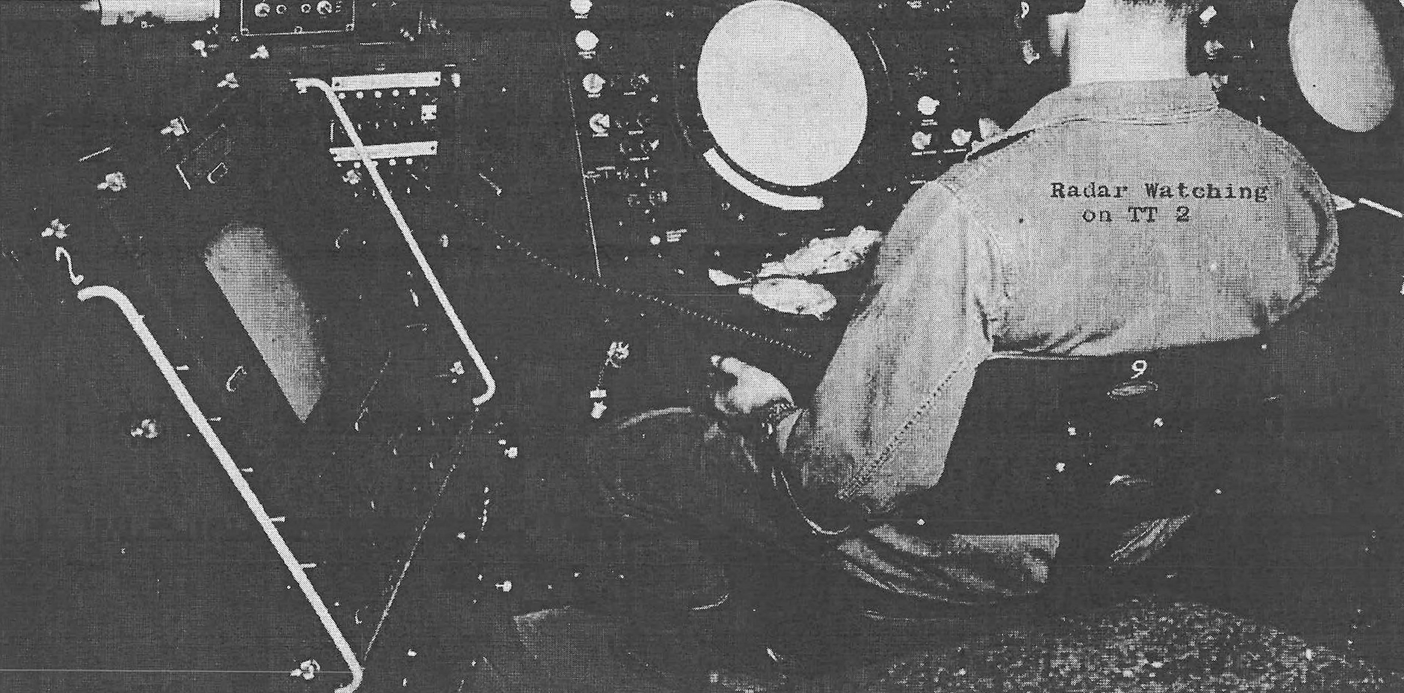
The tower's primary intended sensor was a long-range search radar providing azimuth and range. Two height finders would have measured altitude for selected tracks, while identification equipment helped distinguish friendly and unknown aircraft. Operators would have correlated returns and passed usable track information to mainland control facilities. The mission supported early warning and ground-controlled interception rather than weapons employment on the platform itself.
The prototype and early towers initially used AN/FPS-3-series search radars and paired AN/FPS-6 height finders, with later upgrades including AN/FPS-20-family and AN/FPS-67 search equipment. TT-5 was canceled before an installation schedule could be completed, so it is inaccurate to assign that full operating sequence to Browns Bank. A tower built later might have skipped early equipment or adopted a revised configuration. The record supports intended functions more strongly than a final model-by-model equipment table.
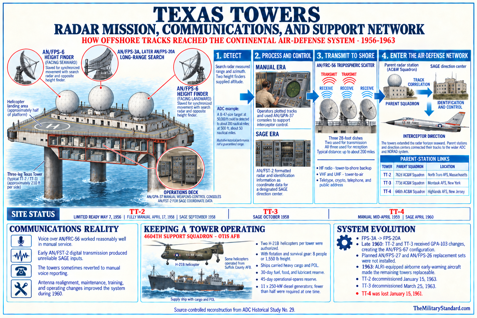
Communications were as important as detection. A radar plot that could not reach a control center had little tactical value, and an offshore crew needed administrative, maintenance, weather, aviation, marine, and emergency channels. Completed towers used radio and tropospheric-scatter systems as their communications matured. TT-5 likely required comparable paths to one or more mainland nodes, but no recovered frequency plan, antenna layout, call sign, or activated circuit establishes its final arrangement.
The proposed station emerged during the transition from manual plotting to SAGE. Early tower operations passed tracks by manual procedures, while later equipment converted radar data for automated processing in a direction center. TT-5 would have been expected to fit the evolving network if it survived into operation. Cancellation means it had no manual-readiness date, SAGE-acceptance test, data-link cutover, operational evaluation, or recorded radar track.
Electronic countermeasures, identification, maintenance, calibration, and weather reporting would also have affected reliability. Sea clutter, anomalous propagation, antenna vibration, radome condition, and communications outages could degrade surveillance. Experience at the completed towers revealed practical problems that planning estimates could not fully predict. TT-5 inherited those anticipated technical burdens on paper, but it produced no site-specific failure statistics or performance reports.
The absence of operations also limits how the word mission should be used. TT-5 had an intended mission approved within a defense program, but it never received an operational mission under an activated commander. It did not provide warning to Canada or the United States, direct an interceptor, identify a flight, or fill a measured coverage gap. Its value to history lies in what planners expected and why they later decided the requirement could be met differently.
Planned Units, Parentage, and Support
No Air Force squadron activated at Browns Bank, and no crew was assigned to an operating TT-5. Later radar-site indexes associate TT-5 with the 654th Aircraft Control and Warning Squadron, whose mainland service included Grenier Air Force Base. That association may preserve a parentage plan, a geographic reporting concept, or an abandoned administrative assignment. Without an activation order or unit history explicitly assigning a TT-5 detachment, it must remain qualified rather than presented as accomplished service.
Some later summaries state that a 4604th Support Group was planned for Pease Air Force Base to support TT-5. The operating tower system instead developed specialized support organizations at Otis Air Force Base, including the 4604th Aircraft Control and Warning Squadron and its successor support organization. The Pease statement may reflect an earlier expansion plan for the northern towers. No recovered order confirms that a TT-5 support group activated at Pease, occupied facilities, or received dedicated aircraft and vessels.
The distinction between operational parent and logistic supporter matters. Completed towers initially related to coastal radar squadrons for radar operations, while the 4604th organization centralized helicopter, supply, maintenance, and administrative support. TT-5 might similarly have had a radar parent and a separate support structure. Its cancellation occurred before those relationships became an operating chain of command, so no commander roster, detachment designation, or permanent-party manning document exists.
Canadian organizations also should not be assigned casually. Browns Bank lay near approaches monitored by the Canadian and American continental air-defense partnership, and the Pinetree Line placed radars across Canada. That strategic proximity does not prove a Royal Canadian Air Force unit, Canadian base, or later NORAD region would have operated the American tower. The available histories describe TT-5 as a United States Air Force project managed through American Air Defense Command and Navy engineering channels.
Planning probably involved coordination beyond a normal domestic construction project. Marine surveying south of Nova Scotia could raise navigation, fisheries, jurisdictional, diplomatic, and safety questions even before the later 200-mile zones and 1984 maritime boundary. The public Air Force histories do not reproduce diplomatic notes, Canadian permits, or a bilateral station agreement. The absence of those documents prevents a confident claim about what approvals were obtained or still required when the project was canceled.
Planned Logistics and Human Experience
A built TT-5 would have depended on both air and sea support. Helicopters offered faster movement of personnel, mail, urgent parts, and medical cases, but fog, icing, wind, payload limits, and mechanical condition could stop flights. Ships carried fuel, food, heavy equipment, and bulk stores, yet transfers required favorable sea and tide conditions. Browns Bank's distance and Canadian offshore setting would have made schedule coordination especially important.
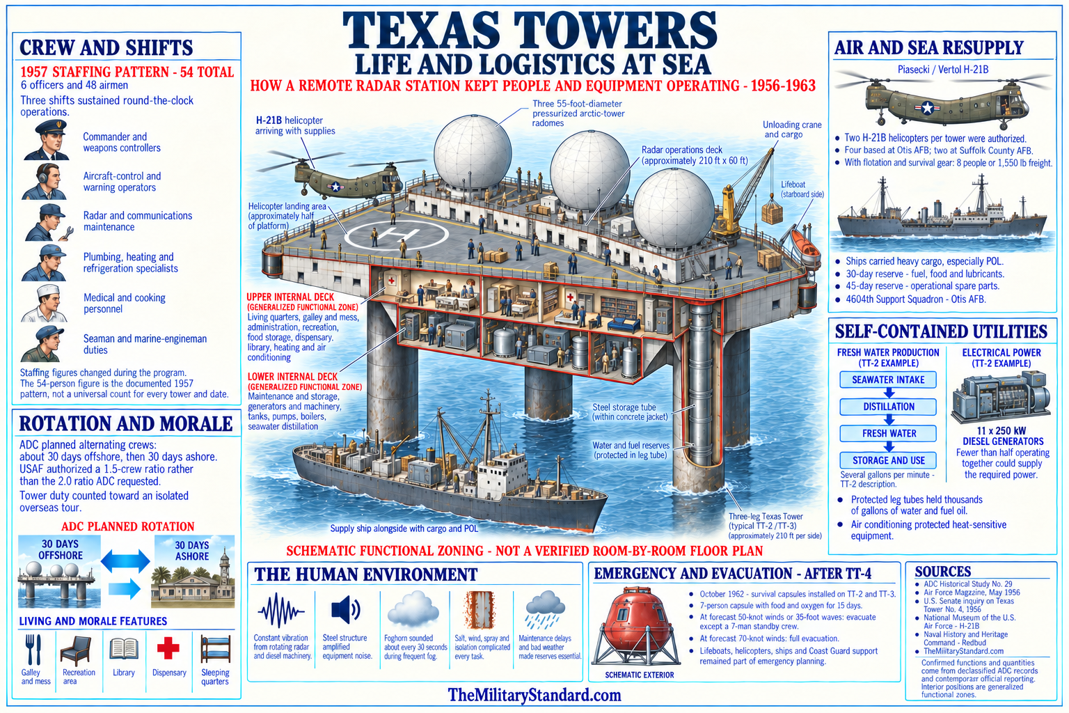
Completed tower crews included radar operators, communications specialists, electronics technicians, power-production personnel, refrigeration and utilities specialists, cooks, medics, administrators, and leaders. Early estimates of approximately twenty-two men proved too small, and later crews commonly approached fifty or more. TT-5 never generated an authorized or actual crew roster that can be verified. Staffing figures from TT-2, TT-3, and TT-4 show the likely occupational range but not the Browns Bank manning total.
Life on an offshore platform combined military duty with the sensory effects of a steel structure at sea. Generators and rotating antennas produced vibration, machinery created continuous noise, salt spray accelerated corrosion, and weather could isolate crews. Recreation, privacy, sleep, food, medical response, and morale therefore became operational concerns. These experiences belong to the completed towers and illuminate the environment TT-5 planners were accepting, but no veteran can accurately claim duty on a platform that was never built.
Emergency planning would have required lifeboats or rafts, survival gear, firefighting equipment, medical evacuation procedures, weather observation, and redundant radio. Later experience and the TT-4 disaster made such issues painfully concrete, but TT-5 disappeared from the program before those events. It is anachronistic to say the 1961 collapse caused its cancellation. The correct causal sequence places TT-5's late-1956 termination more than four years before TT-4 was lost.
Support cost extended well beyond the steel platform. The Air Force had to fund radar equipment, power generation, radomes, communications, helicopters, ships or contracted marine services, spare parts, crew rotation, training, corrosion control, and mainland facilities. Each additional tower increased recurring expense and the number of assets required during bad weather. The northern end sites therefore faced scrutiny not only for construction cost but for the lifetime cost of maintaining coverage that other sensors might increasingly provide.
Why TT-5 was not Built
Headquarters Air Force pressed to remove TT-1 and TT-5 as economy measures while the prototype and contracted towers moved forward. Air Defense Command initially resisted because the two end sites contributed to the geographic continuity of the proposed chain. The disagreement shows that cancellation was a defense tradeoff rather than a conclusion that Browns Bank had never mattered. Planners compared the marginal warning value of the end sites with their capital and recurring costs.
By late 1956 Air Defense Command accepted elimination of both projects. Official histories explain that expanded coastal Aircraft Control and Warning coverage was expected to cover the Cashes Ledge and Browns Bank sectors. Improving shore radars, changing network geometry, airborne warning, picket forces, and SAGE development all influenced the value of a fixed tower. The evidence supports coastal-coverage substitution as the stated immediate rationale, with economy as the institutional pressure behind reconsideration.
TT-5's location magnified the decision. Supporting a tower south of Nova Scotia would have extended construction and logistics farther from the existing Otis-centered system and potentially required a Pease or other northern support complex. It also raised maritime and bilateral questions that did not burden domestic shore stations in the same way. The sources do not identify jurisdiction as the formal cancellation reason, so it should be treated as a contextual complication rather than a proven cause.
The prototype experience also mattered indirectly. TT-2 demonstrated that offshore platforms could carry heavy radar, but it exposed vibration, corrosion, weather, supply, maintenance, and personnel demands. Contracts for TT-3 and TT-4 had already committed the Air Force to a reduced three-tower system. Canceling the uncontracted end sites allowed the service to limit further exposure while preserving the central part of the concept.
The cancellation occurred before the later strategic shift toward ballistic missiles fully transformed continental defense. Intercontinental ballistic missiles reduced the relative importance of bomber-only warning systems by the early 1960s, but that later change did not initiate the 1956 TT-5 decision. The accurate explanation remains early economy pressure and anticipated coastal radar improvement within a rapidly changing bomber-defense network. Later missile developments help explain why the project was never revived.
Result of Cancellation
Cancellation ended TT-5 before land or seabed acquisition, platform fabrication, emplacement, equipment installation, beneficial occupancy, unit activation, or operational testing. There was no formal station opening and therefore no conventional closure ceremony. The 1956 date used is a planning termination, not an inactivation of personnel at Browns Bank. No Air Force family housing, cantonment, utility system, hospital, chapel, exchange, or recreational facility ever existed there.
The project left no known military wreck or debris field. TT-2 and TT-4 have submerged remains because completed structures were lost or demolished at sea, and TT-3 was removed. TT-5 has no comparable archaeological site. A charted obstruction, shipwreck, cable, buoy, or other feature near the representative coordinate must not be labeled a Texas Tower remnant without direct evidence.
There was also no military property transfer. The Air Force did not convey a tower to Canada, a private owner, Fisheries and Oceans Canada, the Canadian Coast Guard, or a conservation organization. Modern fisheries boundaries and conservation proposals are regulatory or ecological designations for the natural marine area. They are not reuse of an American defense parcel and do not establish succession from TT-5.
The most tangible legacy is documentary. TT-5 appears in program authorizations, survey histories, site tables, maps, and later radar-site catalogs. Its cancellation shaped the final three-tower network and illustrates how planners traded theoretical coverage against cost and emerging alternatives. Preserving a separate record prevents the unbuilt northeastern endpoint from disappearing into histories focused only on the three staffed structures.
Role in the Wider Military Network
TT-5 occupied a planned position between American continental defense and the northeastern Atlantic approaches. Its proposed radar would have extended warning beyond coastal stations and contributed tracks to shore-based command and interceptor systems. The site also sat near routes relevant to Canadian defense, the Pinetree Line, maritime patrol, and the emerging bilateral air-defense framework. That geography made it strategically interesting even though no evidence shows a Canadian unit would have staffed it.
Within the five-tower concept, Browns Bank was the northeastern endpoint. TT-1 and TT-5 bracketed the three platforms that were eventually built, while the central towers covered Georges Shoal, Nantucket Shoal, and the approaches off New Jersey. Removing both endpoints shortened the array and concentrated investment where construction contracts already existed. The revised network accepted more reliance on coastal, airborne, and mobile sensors in the northern sectors.
The likely 654th association links TT-5 conceptually to the New Hampshire radar organization around Grenier, while the reported Pease support plan links it to a major northeastern Air Force base. Neither relationship became an operating assignment. The registry therefore records them as planned or indexed relationships, not parent units equivalent to the verified 762d and North Truro connection for TT-2.
The 4604th organization at Otis demonstrated how a dedicated mainland system supported the completed towers. Helicopters, marine lift, maintenance, supply, administration, and emergency coordination had to function as one network. A completed TT-5 probably would have required expansion or geographic redistribution of that support. The later Pease claim is plausible in this context because Browns Bank lay far northeast of Otis, but the exact organizational plan remains an unresolved research question.
SAGE changed how remote radars contributed to defense. Instead of treating each station as an isolated plotting room, the system converted and transmitted radar information to computerized direction centers that assembled a wider air picture. TT-5 was conceived before SAGE became operational and canceled while the transition was underway. Its history therefore captures a design caught between manual Aircraft Control and Warning practice and a more automated network that increasingly valued reliable data links and sensor integration.
Navy radar picket ships and airborne early-warning aircraft supplied another layer. They could move, adapt to changing routes, and operate beyond fixed shallow banks, though they consumed crews, fuel, maintenance, and operating hours. Fixed towers offered persistence and heavy antennas but could not relocate and were expensive to build and sustain. The final defense architecture used a mixture of systems, and the cancellation of TT-5 represents one point where mobile and coastal alternatives outweighed an additional permanent offshore platform.
The project also belongs in the history of United States-Canadian defense cooperation even without a bilateral operating agreement. A radar south of Nova Scotia would have observed airspace and approaches of interest to both countries. NORAD was formally established in 1957, after TT-5 was dropped, but earlier cooperation already connected continental warning plans. The absence of a constructed tower means TT-5 contributed no operational tracks to that partnership, yet its planned location shows how defense geography crossed political boundaries.
Current Browns Bank Status
Browns Bank remains an extensive natural offshore bank south of Yarmouth and southwest Nova Scotia. Canadian Hydrographic Service sailing directions describe a sandy rise, greater surrounding depths, and separation from Georges Bank by the Fundian Channel. The bank forms part of a complex shelf ecosystem rather than a military industrial site. Mariners must rely on current official Canadian charts and notices, not the representative TT-5 coordinate or a historical military map.
Fisheries and Oceans Canada manages active fisheries in and around Browns Bank. The offshore scallop fishery divides Browns Bank into northern and southern management areas, and groundfish rules include seasonal or area restrictions. Lobster Fishing Area 40 was established as a closed area to protect broodstock. These measures concern living marine resources and fishing activity; they are not security zones around a former Air Force station.
The Fundian Channel-Browns Bank Area of Interest includes part of Browns Bank and nearby channel, basin, slope, coral, and sponge habitats. Fisheries and Oceans Canada identified the area in 2018 for conservation consideration and reports significant sponge concentrations on Browns Bank and important coral habitat in the Northeast Channel. A portion already lies within a marine refuge. The proposed conservation geography is much larger than a single historical TT-5 point and must not be represented as the military site's boundary.
Scientific work has mapped the bank's bathymetry, sediments, oceanography, fish, invertebrates, seabirds, and commercial harvest. Multibeam surveys and geological studies reveal seabed variation that 1950s engineers could examine only through more limited soundings and cores. This modern information improves geographic context but cannot retroactively establish the exact point selected for a caisson. The military and scientific coordinate systems answer different questions and should remain labeled separately.
The International Court of Justice established the single maritime boundary in the Gulf of Maine area in 1984. The later TT-5 representative point lies east of the boundary segment relevant to Georges Bank and in the Canadian offshore setting reflected by current Canadian sources. That modern result should not be projected backward as though the 1954 Air Force used today's settled legal framework. During planning, the United States and Canada had not yet resolved the later 200-mile continental-shelf and fisheries-zone boundary.
Chronology
- 1946 through 1951 Air Defense Command and related organizations examined ways to extend aircraft warning seaward beyond coastal radar line-of-sight limits.
- 1948 through 1952 Shore radars, picket concepts, airborne warning, and experimental automatic-control projects created the layered setting for a fixed offshore radar proposal.
- August 1, 1952 MIT Lincoln Laboratory outlined the oil-platform-based fixed radar concept that became the Texas Tower program.
- 1952 through 1953 Planners studied shallow Atlantic banks capable of supporting heavy radar platforms, including the northeastern approaches near Nova Scotia.
- Autumn 1953 The Secretary of the Air Force authorized a five-tower construction program on Air Defense Command's recommendation.
- January 11, 1954 Later site summaries identify this as the approval date for Texas Tower No. 5, although the underlying site memorandum remains unverified.
- March 1954 The Air Force authorized the Navy Bureau of Yards and Docks to prepare contract plans and specifications for the offshore program.
- March 1954 Browns Bank received the project designation TT-5 within the five-site sequence.
- March 1954 Cashes Ledge, Georges Shoal, Nantucket Shoal, and Unnamed Shoal received the corresponding TT-1 through TT-4 designations.
- July 1954 The Navy contracted with the DeLong and Raymond joint venture for core drilling at the proposed sites.
- Summer 1954 Engineers and government agencies surveyed the five candidate areas, including Browns Bank.
- October 1954 The common feasibility report for the Texas Tower candidate sites was completed.
- December 1954 The Navy awarded Bethlehem Steel the contract for the first platform.
- December 1954 Air Defense Command selected TT-2 at Georges Shoal as the prototype because of shallow water and its relationship to the first semi-automatic defense area.
- Spring 1955 Bethlehem Steel completed major fabrication of the TT-2 platform at Quincy while TT-5 remained an uncontracted future project.
- May 20, 1955 TT-2 was launched, providing the program's first physical test of the common platform concept.
- July 1955 TT-2 was towed to Georges Shoal and erected, generating engineering and cost experience relevant to the remaining projects.
- November 1955 Bids for TT-3 and TT-4 moved forward while TT-1 and TT-5 remained the uncontracted ends of the original chain.
- December 2, 1955 Air Defense Command accepted beneficial occupancy of TT-2.
- December 1955 Official histories record that expanded coastal radar coverage was already anticipated in the Cashes Ledge and Browns Bank sectors.
- Early 1956 Air Defense Command continued evaluating the five-site program against cost, construction experience, coverage, and support requirements.
- March 12, 1956 Air Defense Command issued a logistics support plan for the developing operational Texas Tower system.
- May 7, 1956 TT-2 reached limited operational readiness, providing practical evidence about offshore radar operation and support.
- August 1956 TT-3 was launched, towed, and erected at Nantucket Shoal.
- September 28, 1956 The 4604th Aircraft Control and Warning Squadron (Texas Towers) activated at Otis Air Force Base for the operating tower system.
- October 8, 1956 The 4604th assumed specialized support responsibility for the developing completed towers.
- Late 1956 Headquarters Air Force sought economy by eliminating TT-1 and TT-5, while Air Defense Command initially opposed removing the end sites.
- Late 1956 Air Defense Command accepted cancellation after expected coastal Aircraft Control and Warning coverage reduced the need for the two end towers.
- Late 1956 TT-5 ended before a Browns Bank platform contract, fabrication, emplacement, equipment installation, unit activation, or occupancy.
- 1957 The United States and Canada established NORAD after the TT-5 project had already been dropped.
- November 1957 TT-4 entered the completed tower system, leaving the operating program at three platforms rather than the five originally authorized.
- 1958 The completed towers moved from early manual operation toward SAGE integration while TT-5 remained canceled.
- September 1958 TT-2 entered SAGE operation, demonstrating the automated network role TT-5 never received.
- April 1960 TT-3 entered SAGE operation, completing the transition of another surviving platform.
- January 15, 1961 TT-4 collapsed during a winter storm, more than four years after TT-5 had been canceled.
- 1961 through 1962 Ballistic-missile warning and changing airborne-surveillance arrangements further reduced the strategic case for reviving the canceled end towers.
- January 15, 1963 TT-2 was decommissioned.
- March 25, 1963 TT-3 was decommissioned.
- September 1963 TT-2 was demolished at sea, producing a wreck that has no TT-5 equivalent.
- 1963 TT-3 was removed and dismantled, ending the staffed Texas Tower program.
- 1979 Fisheries and Oceans Canada established Lobster Fishing Area 40 on Browns Bank as a closed area to protect broodstock.
- March 29, 1979 Canada and the United States signed the special agreement that later submitted Gulf of Maine maritime delimitation to an International Court of Justice chamber.
- October 12, 1984 The International Court of Justice issued its Gulf of Maine maritime-boundary judgment.
- 1998 Canadian offshore scallop management divided Browns Bank into northern and southern areas based on productivity and fishing patterns.
- March 2018 Fisheries and Oceans Canada identified the Fundian Channel-Browns Bank Area of Interest for marine-conservation consideration.
- 2023 The Canadian Science Advisory Secretariat published a biophysical and ecological overview of the Fundian Channel-Browns Bank study area.
- 2025 Current Canadian sailing directions continued to describe Browns Bank as an extensive western Nova Scotia bank with a least-depth sandy rise and separation from Georges Bank by the Fundian Channel.
Information sources (35)
- PDFAir Defense Command, ADC Historical Study No. 10, Seaward Extension of Radar, 1946-1956
Primary program history for the Lincoln Laboratory concept, five-site authorization, Navy engineering, 1954 surveys, feasibility work, and TT-2 prototype selection.
- PDFAir Defense Command, ADC Historical Study No. 29, A History of Texas Towers in Air Defense, 1952-1964
Primary command study for program development, construction, organization, operations, logistics, cancellation of TT-1 and TT-5, and final disposition.
- PDFAir Defense Command, ADC Historical Data, 1946-1973 (17.67 MB)
Its Texas Tower operating table lists only TT-2, TT-3, and TT-4, supporting the distinction between the three operating stations and unbuilt TT-1 and TT-5.
- PDFOffice of Air Force History, The Emerging Shield: The Air Force and the Evolution of Continental Air Defense, 1945-1960
Official synthesis for the bomber threat, Lincoln Laboratory proposal, five authorized sites, coastal-coverage rationale, and wider air-defense network.
- WEBOffice of Air Force History, Air Defense Command and Antibomber Defense, 1946-1972
Official command context for continental radar, interceptors, airborne warning, SAGE, and changing threats.
- PDFAir Force Civil Engineer Center, Leading the Way: The History of Air Force Civil Engineers
Official engineering history summarizing the five Texas Tower sites and cancellation of TT-1 and TT-5 after anticipated coastal-radar improvements.
- WEBUnited States Senate Committee on Armed Services, Inquiry into the Collapse of Texas Tower No. 4
Congressional record containing common-design, engineering, organization, safety, and program evidence useful for distinguishing intended TT-5 features from constructed platforms.
- WEBMIT Lincoln Laboratory, SAGE: Semi-Automatic Ground Environment Air Defense System
Institutional history for the automated network context in which Texas Tower data was expected to operate.
- WEBAir Combat Command, AFNIC History
Official Air Force communications history describing manual air-defense reporting, long-distance communications, SAGE-era change, and later missile-warning demands.
- WEBNaval History and Heritage Command, Bureau of Yards and Docks
Official institutional reference for the Navy engineering bureau that served as Air Force design and construction agent.
- PDFAir Force unit-history compilation, 4604th Support Squadron
Secondary transcription of official lineage and support material for helicopters, mainland support, and organizational transition.
- WEBRadomes, Texas Towers program page
Specialist historical compilation with photographs, program links, intended radar arrangement, and explicit statement that TT-1 and TT-5 were not built.
- WEBRadomes, New Hampshire radar-site index
Specialist catalog associating unbuilt TT-5 with Browns Bank and the 654th, used only as a qualified planning lead.
- PDFCanadian Hydrographic Service, ATL 100: General Information, Atlantic Coast, 2025 edition
Official sailing directions for Browns Bank position, least depth, bottom, relation to Baccaro and Georges banks, and Fundian Channel.
- WEBFisheries and Oceans Canada, Fundian Channel-Browns Bank Area of Interest
Official current location, approximate area, habitat, coral, sponge, and conservation-planning information.
- WEBFisheries and Oceans Canada, Socio-economic Profile of Marine Harvest Activities in the Fundian Channel-Browns Bank Area of Interest
Official fisheries, gear, landed-value, and study-period context.
- WEBCanadian Science Advisory Secretariat, Research Document 2023/058, Biophysical and Ecological Overview of the Fundian Channel-Browns Bank Area of Interest
Official scientific synthesis of bank, channel, slope, basin, fish, invertebrate, seabird, coral, and sponge features.
- WEBFisheries and Oceans Canada, The Scotian Shelf: An Atlas of Human Activities
Official regional account of fisheries, Browns Bank closures, offshore lobster, scallop, and groundfish activity.
- WEBFisheries and Oceans Canada, Offshore Scallop Integrated Fisheries Management Plan
Official identification of Browns and German Banks as Scallop Fishing Area 26 and the north-south Browns Bank management division.
- WEBFisheries and Oceans Canada, Groundfish 4VWX5 Integrated Fisheries Management Plan
Official current framework for groundfish management and seasonal Browns Bank restrictions.
- WEBFisheries and Oceans Canada, Offshore Lobster and Jonah Crab Integrated Fisheries Management Plan
Official history and purpose of the Browns Bank Lobster Fishing Area 40 closure.
- WEBFisheries and Oceans Canada, 2017 Offshore Scallop Fishery Decision
Official coordinates and management description for Browns Bank North and South.
- PDFInternational Court of Justice, Delimitation of the Maritime Boundary in the Gulf of Maine Area, Judgment of October 12, 1984
Primary legal source for the modern single maritime boundary between Canada and the United States.
- WEBInternational Court of Justice case page for Delimitation of the Maritime Boundary in the Gulf of Maine Area
Official judgment, opinions, orders, pleadings, and procedural record.
- PDFGovernment of Canada, Environmental Studies Research Fund Regions Regulations
Current legal text referencing the 1984 maritime boundary and Georges Bank exclusion-zone geography.
- WEBFisheries and Oceans Canada, Current Meter, Meteorological, and Sea-Level Observations for Browns Bank, Nova Scotia, April 1983 to May 1985
Official oceanographic data catalog and report.
- PDFCanadian Science Advisory Secretariat, 2026 Browns Bank scallop assessment material
Official record describing multibeam bathymetry and seabed mapping used for modern survey design.
- PDFGeological Survey of Canada, marine geological mapping overview
Official description of coarse-grained deposits, sand bodies, till, and multibeam interpretation around Browns and neighboring banks.
- PDFFisheries Research Board of Canada, historical offshore scallop exploration
Government research documenting a Browns Bank scallop bed encountered in 1954 and the bank's fisheries significance during the TT-5 planning period.
- PDFNOAA repository, Gulf of Maine regional map
Government-hosted geographic reference showing Browns Bank, Georges Bank, channels, and surrounding basins.
- PDFAir Force Civil Engineer Center, former Pease Air Force Base site description
Official history placing development of the Portsmouth base in the same 1951-1956 period and documenting its primary Strategic Air Command role.
- WEBAir Force Historical Support Division, Pease, Capt. Harl Pease Jr
Official source for the September 7, 1957 naming of Portsmouth Air Force Base as Pease Air Force Base.
- PDF157th Air Refueling Wing, Granite Wings: A History of the New Hampshire Air National Guard
Official state Air Guard history providing Pease and New Hampshire military-aviation context.
- WEBAir Force Historical Research Agency, Evolution of the Department of the Air Force
Official institutional context for the post-1949 Soviet atomic threat, 1950s air defense, missiles, and competing modernization priorities.
- WEBRadomes, Texas Tower No. 5 historical listing and later-site compilation
Secondary project reference used for the representative coordinate, approximate distance and depth, January 1954 date, and proposed support claim, all explicitly qualified against primary and modern official evidence.