
Cape Lisburne Air Force Station / Cape Lisburne Long Range Radar Site, Alaska
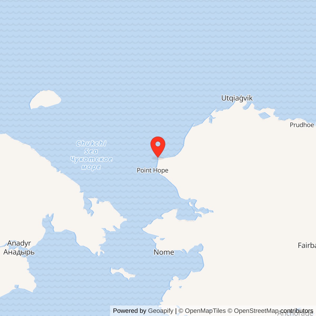
Longitude: -166.091284
Current Role: Active Alaska Radar System AN/FPS-117 long-range radar at upper camp, with lower-camp airfield and support; multiple environmental management areas retain separate monitoring and controls.
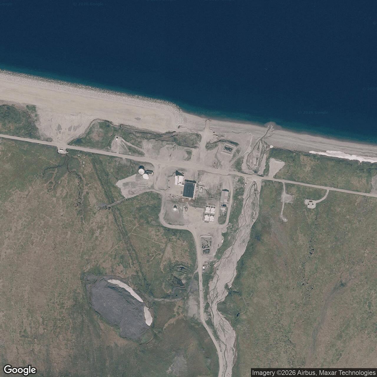
Coordinate note: 68.872098 N, 166.091284 W is Alaska DEC's WGS84 installation-wide environmental case point near the lower camp. It is not the upper radar, a White Alice antenna, the runway threshold, property centroid, or surveyed boundary. DEC's White Alice OT003 point, 68.869222 N, 166.152299 W, was moved using a coarse places-of-interest data set and is not a surveyed antenna location.
- Radar role
- Arctic aircraft warning from February 1953; LIZ-1 DEW Line assignment 1957 to 1969; continuing long-range radar surveillance.
- Communications role
- Co-located White Alice tropospheric-scatter terminal, 1957 to May 1979.
- Local unit
- 711th Aircraft Control and Warning Squadron in the staffed era.
- Radar equipment
- AN/FPS-3, modified to AN/FPS-20A, later AN/FPS-93A; AN/FYQ-9 data equipment; AN/FPS-117 from 1985.
- Present identity
- Active Cape Lisburne Long Range Radar Site. The former White Alice component and LIZ-1 assignment were not separate installations.
Overview
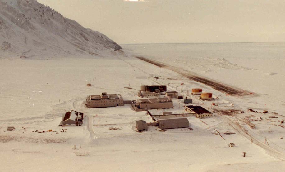
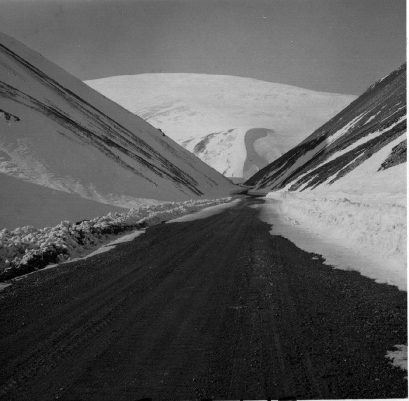
Cape Lisburne Air Force Station began as one of Alaska's permanent aircraft-control-and-warning stations and remains an active long-range radar site. It occupies a remote headland on the Chukchi Sea, roughly 35 to 40 miles northeast of Point Hope. The original arrangement separated a lower coastal camp, runway, and support buildings from radar facilities on a ridge about 1,585 feet above sea level. A road and, for part of the staffed era, an aerial tram connected the camps. This geography gave the radar an open northern and western horizon but made every construction season, resupply operation, equipment repair, and personnel rotation unusually difficult. The installation was also a terminal in the original White Alice Communications System. Its radar and communications histories are related but not interchangeable: the White Alice mission ended in 1979; radar surveillance continued through conversion to a minimally attended long-range radar site. [1] [2] [3]
Identity, land, and location
The Cape Lisburne radar station was a single Air Force installation with a co-located White Alice component. Its original AC&W site code was F-07. The 1994 Corps history separately lists the same place as LIZ-1 in the Alaskan DEW Line network, with an August 1957 network entry and 1 June 1969 inactivation for that DEW assignment. Those dates do not replace the February 1953 AC&W opening or close the continuing radar installation. Conflicting later A-series codes remain unresolved. References to a Cape Lisburne White Alice site describe a function and cleanup area within the host installation, not evidence for a second independent installation UID. The 2019 Air Force natural-resources appendix describes a 1,123-acre LRRS in the Chukchi Sea Unit of the Alaska Maritime National Wildlife Refuge. That is a reported management-area figure, not a surveyed parcel polygon. Its upper camp is about 1,600 feet above mean sea level; the lower camp is near 50 feet. A winding road between them is reported at 3.9 miles. [1] [2] [3]
Coordinate labels matter at this split installation. Alaska DEC lists 68.872098 N, 166.091284 W, WGS84, for its installation-wide environmental case. That is a representative case point in the lower-camp area, not a radar tower, White Alice antenna, runway threshold, property centroid, or boundary. DEC separately lists 68.869222 N, 166.152299 W, WGS84, for the White Alice OT003 environmental case, but says it moved that point in 2005 using a coarse Census places-of-interest data set. [4] [5]
Selection and construction, 1949 to 1953
Alaskan Air Command and the Army Corps of Engineers surveyed the Cape Lisburne area in 1949. The high ground, exposed horizon, and position on the northwest approach made it a logical early-warning location. A June 1950 contract went to Gaasland & Company. The contractor built upper and lower camps and a connecting tramway; an Air Force history places completion of that major construction in August 1952 at approximately $4.47 million. The standard initial program had 21 buildings designed for an 89-person workforce, though later operational manning exceeded that planning figure. Construction and operational dates should not be conflated: the 711th squadron was activated in December 1952, while the radar joined the Alaskan early-warning system on 11 February 1953. [1] [2] [6]
The first detachment arrived by ship on 21 June 1951 and offloaded hundreds of tons in dangerous wind and surf. Sources disagree on its exact parent-unit designation: the later Argonne history names Detachment F-7 of the 532nd Aircraft Control and Warning Group, while the compiled 711th unit account calls it Detachment F-7 of the 142nd Aircraft Control and Warning Squadron. Both identify F-7 at Cape Lisburne and its succession by the 711th on 8 December 1952. An emergency lagoon strip was prepared in 1952, a station airstrip in 1953, and the runway was expanded in 1956. Air deliveries supplemented annual sealift, initially called Mona Lisa and later Cool Barge. The runway, fuel, water, and marine access were not peripheral conveniences: without them the isolated radar could not remain staffed. [1] [2] [6]
The staffed radar and its mission
The original search radar was Campion and, after a 1973 realignment, Murphy Dome. A Corps DEW Line table also places the site at the western end of the LIZ sector in 1957 to 1969, alongside the distinct LIZ-2 station at Point Lay. Its listing of AN/FPS-20 for the entire DEW period is less precise than the site-specific evidence for a 1958 AN/FPS-3-to-20A conversion. The radar's role in wider defense was therefore to extend detection and pass usable information onward, not merely to rotate an antenna at a remote point on a map. [1] [2] [6]
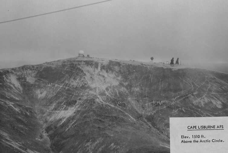
Radar and shelter technology changed repeatedly. An inflatable radome and twelve-person upper-camp quarters were added in 1955. The inflatable dome proved troublesome and was replaced by a rigid one in June 1961. In summer 1958, a CPA-27 modification converted the AN/FPS-3 to AN/FPS-20A, accompanied by UPA-35 plan-position-indicator consoles. The radar later became AN/FPS-93A after further modifications, with a simulator installed in July 1969 and a video mapper later that year. AN/FYQ-9 data equipment entered operation in 1965, reducing manual track-processing demands. One compiled squadron narrative mentions a 1952 AN/FPS-7 installation team, but the authoritative site history and the same squadron narrative identify the operating radar as AN/FPS-3. [1] [6]
The environment shaped operations as much as the equipment did. In 1954 the station had six officers, 132 airmen, and three civilians, more than the original building design anticipated. A March 1954 fire destroyed the dispensary, administrative records, and bachelor officers' quarters, while a shortage forced strict water rationing. Fires also affected a transmitter building in 1956, the commissary in 1957, and dining and officers' quarters in 1962. Winter weather could close the upper-camp road almost as soon as it was cleared. On 24 October 1957, according to the squadron account, personnel even turned the radar antenna by hand while its drive was being repaired. By June 1965 the installation had 26 buildings, including upper-camp facilities; the lower camp held operations and weather functions, dining, medical care, recreation, fire protection, power, quarters, and other support. These details show the daily labor behind an uninterrupted warning mission. [1] [6]
White Alice communications, 1957 to 1979
At first Cape Lisburne relied on high-frequency radio and unreliable voice and teletype circuits. The 711th account reports extremely poor monthly communications availability in the early period, making it possible to detect a target but difficult to pass the warning promptly. Direct voice contact with Campion improved in 1955 yet remained weak. White Alice tropospheric-scatter equipment was installed in summer 1957. The Corps history gives 29 August 1957 as its opening date, while the later Air Force site history gives the less precise September 1957 activation month; the squadron records a successful direct voice exchange with Campion on 13 September. Those statements may reflect different construction, acceptance, and operating milestones. The substantive improvement was that telephone, teletype, and radar reporting could move more reliably through the network. [1] [2] [6]
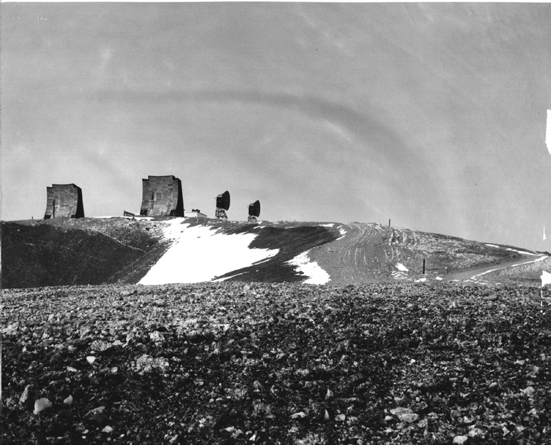
Cape Lisburne belonged to the original 31 White Alice installations and was one of the co-located radar/communications sites. The 1994 Corps history places it among the original tropospheric-scatter stations and explains that co-located stations generally shared housing and services rather than duplicating a full dormitory complex. Citing a 1988 account, it describes Cape Lisburne as the northernmost and only seasonal White Alice terminal, not used during winter; the exact seasonal operating pattern has not been independently checked against station logs. Its historic equipment and power building was reported at 2,960 square feet. A replacement composite building constructed during 1968 to 1970 was described as an unusually elaborate $6.5 million facility. The 1988 Corps inventory specifically identifies direct tropospheric-scatter links from Cape Lisburne to Kotzebue, 168 miles south, and to the separate Point Lay DEW Line station. It identifies a pair of 60-foot antennas for Kotzebue and a second antenna pair for Point Lay. The source does not settle the latter pair's exact dimensions or bearing. [1] [2] [8]
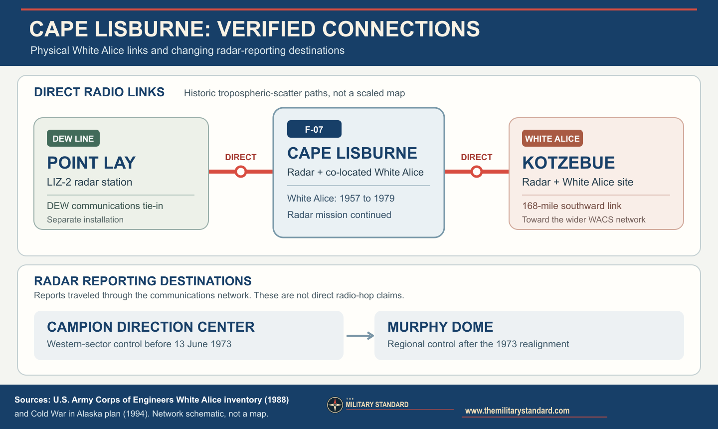
White Alice was a communications system, not a radar type. Its tropospheric-scatter antennas sent radio energy toward the lower atmosphere to bridge distances beyond ordinary line of sight, relaying command, reporting, and telephone traffic. At Cape Lisburne that function was particularly valuable because the station's first HF links had limited the usefulness of its radar reports. Satellite communications superseded the local White Alice service. The squadron account dates formal shutdown to 21 May 1979; the Argonne history gives May 1979. The White Alice infrastructure subsequently became an environmental cleanup area, while the host radar installation continued. [1] [2] [6]
Contract operation and remote radar, 1977 onward
Alaskan Air Command began moving support work to RCA contractors in 1977. The Cape Lisburne operations-and-maintenance contract was awarded on 27 May, and the first contractors arrived 12 June. Military positions fell sharply, but the change did not end the radar mission. Joint Surveillance System improvements by 1982 enabled radar information to move by satellite toward the Regional Operations Control Center at Elmendorf. With that center operational in 1983, the remaining on-site military organization was withdrawn, the 711th squadron inactivated, and Cape Lisburne became a long-range radar site supported by civilian contractors. Thus 1983 marks an organizational and operating-mode transition, not abandonment of the installation. [1] [2] [6]
Under Seek Igloo, a new AN/FPS-117 minimally attended, three-dimensional radar was installed at upper camp. The Argonne site history dates the upgrade to July 1985, and the 2019 Air Force appendix also places the installation in 1985. The published Argonne text contains the typographic form "AN/FSP-117"; the accepted equipment nomenclature is AN/FPS-117. This radar combined search and height information and allowed a smaller on-site workforce while passing surveillance data into the Alaska Radar System. In 2019 the Air Force reported year-round operation, maintenance, and support by three on-site contractor personnel. That dated staffing figure is not asserted as the exact 2026 headcount. Official environmental and operational records still identify Cape Lisburne as an active LRRS in 2026. [1] [3] [4]
Facilities, heritage, and community setting
The split-camp arrangement left a particularly visible engineering record. The first tramway joined the coastal support area to the upper radar camp; a later replacement or substantial tramway project was reported in the 1960s. The tram ceased use in the early 1970s while the mountain road carried traffic. Composite steel-frame buildings replaced some older construction in 1968. The airfield remained indispensable, and coastal erosion later threatened it. A 2016 to 2020 seawall project reinforced the runway's exposed shore, illustrating how maintaining a remote radar site requires civil works far beyond radar electronics. [1] [2] [3] [7]
The 1994 management plan found only a small fraction of the original 1950s fabric surviving. A 1997 memorandum of agreement provided for Historic American Buildings Survey level-2 documentation before further changes. Major demolition and Clean Sweep restoration followed in 2001 to 2004. A later Argonne inventory named several then-extant structures, including recreation, vehicle-storage, switching, water, industrial, treatment, tank, and radome-tower facilities, plus the airfield and roads. Those are dated inventories, not a guarantee that every item survives today. The site lies within a wildlife-refuge unit and near lands used by Point Hope residents for subsistence. [1] [2] [3]
Environmental record and present condition
Alaska DEC manages multiple Cape Lisburne cleanup components. The former White Alice area is OT003. A 2003 decision called for excavation of PCB-contaminated soil for off-site disposal; work in summer 2004 removed approximately 1,598 cubic yards. Excavation exposed petroleum-odor soil that was investigated in 2005. DEC conditionally closed the White Alice component in 2006 after review of confirmation and screening results, but its current designation is Cleanup Complete - Institutional Controls. That label does not mean unrestricted excavation or that the broader radar site has no remaining issues. Soil disturbance and disposal remain subject to DEC requirements. [4] [5]
The installation-wide DEC case encompasses additional landfill, transformer, fuel, and other areas with differing status. A 2023 five-year review found certain measures at LF001 and CS544 protective in the short term while requiring continued land-use controls and remedy attention. DEC approved a 2025 long-term management report in January 2026 and a 2026 to 2030 work plan in May 2026. These records document continuing stewardship, not closure of the air-defense mission. Public sources used here establish active radar and support facilities but do not support a building-by-building 2026 survival list or public-access claim. Cape Lisburne remains a restricted operational installation, with legacy cleanup and coastal maintenance occurring alongside the radar mission. [4] [5] [7]
Role in the Wider Military Network
Cape Lisburne linked three different kinds of infrastructure. Its radar watched a remote sector of the Arctic approaches and forwarded tracks to command centers; White Alice made that reporting dependable across vast distances; and the runway, sealift, road, power, water, and housing systems kept both missions functioning. Kotzebue and Point Lay were physical communications endpoints, while Campion and, after the June 1973 control realignment, Murphy Dome were radar-reporting destinations. The latter relationship does not imply a dedicated direct antenna hop from Cape Lisburne to either direction center. The 1969 end of Cape Lisburne's DEW listing did not end its AC&W or later LRRS service. The modernization of the 1980s changed Cape Lisburne from a large staffed radar community into one input in a remotely integrated Alaska surveillance system. [1] [2] [3] [6] [8]
Chronology
- 1949 Alaskan Air Command and the Corps of Engineers surveyed the Cape Lisburne area for a permanent warning station.
- 1950-06 Gaasland & Company received the principal station-construction contract.
- 1951-06-21 The first F-7 detachment arrived by ship and began unloading equipment and supplies.
- 1952-08 Major upper-camp, lower-camp, and tramway construction was substantially complete.
- 1952-12-08 The 711th Aircraft Control and Warning Squadron succeeded the construction-period detachment.
- 1953-02-11 The radar station joined Alaska's operational early-warning system.
- 1953 The station runway was constructed; an earlier emergency lagoon strip had been prepared in 1952.
- 1954-03-26 Fire destroyed the dispensary, records, and officers' quarters amid a severe water shortage.
- 1955 Upper-camp quarters and an inflatable radome were installed.
- 1956 The airstrip was expanded.
- 1957-08 The Corps DEW Line table lists Cape Lisburne as LIZ-1 within that network.
- 1957-08-29 The Corps history dates the Cape Lisburne White Alice opening to this day; other sources use September as the activation month.
- 1957-09-13 The squadron recorded a successful direct Campion voice exchange over the new White Alice link.
- 1958 The original AN/FPS-3 was modified to AN/FPS-20A and UPA-35 consoles were installed.
- 1961-06 A rigid radome replaced the troublesome inflatable shelter.
- 1965 AN/FYQ-9 data equipment became operational.
- 1968 New composite buildings were constructed at Cape Lisburne.
- 1969-06-01 The Corps DEW Line table records inactivation of the Cape Lisburne LIZ-1 assignment, not closure of the AC&W radar station.
- 1969 Radar simulation and video mapping were added; the modified search set was identified as AN/FPS-93A.
- 1977-05-27 RCA received the operations-and-maintenance contract; contractor arrivals began in June.
- 1979-05-21 The local White Alice system was formally deactivated in favor of satellite communications.
- 1982 Joint Surveillance System equipment enabled satellite transfer of radar data toward Elmendorf.
- 1983 The resident squadron era ended and Cape Lisburne transitioned to a contractor-supported LRRS.
- 1985-07 The site was upgraded with a Seek Igloo AN/FPS-117 minimally attended radar.
- 1997-10 A preservation agreement provided for HABS-level documentation before major alterations.
- 2001-2004 Clean Sweep activities removed much obsolete construction and addressed legacy contamination.
- 2003 A decision document set the White Alice OT003 PCB-soil remedy.
- 2004 Approximately 1,598 cubic yards of PCB-affected soil were excavated from OT003.
- 2006-09-07 DEC approved conditional closure of the White Alice cleanup component with residual-soil controls.
- 2020-08-12 The runway seawall reconstruction was completed after coastal erosion concerns.
- 2026 The active LRRS and its separate environmental management areas remained in official records.
Information sources (8)
- PDFHistory of the Aircraft Control and Warning System, Argonne National Laboratory for the U.S. Air Force, 2013, especially section 3.6 and heritage discussion
Source for: site selection, construction, camp layout, equipment sequence, White Alice, 1983 to 1985 conversion, preservation and dated structure inventory
- PDFThe Cold War in Alaska: A Management Plan for Cultural Resources, U.S. Army Corps of Engineers, 1994, especially pages 160-161, 197-198, 230-234 and 240
Source for: LIZ-1 and neighboring Point Lay LIZ-2 DEW identities and dates, split-camp facilities, command network, White Alice classification and shared-support pattern
- PDF2019 Pacific Air Force Regional Support Center Remote Sites Integrated Natural Resources Management Plan Update, Appendix H, draft edition 1
Source for: 1,123-acre reported management area, camp elevations and road, active AN/FPS-117 mission, 2019 personnel statement, wildlife-refuge and Point Hope setting
- WEBCape Lisburne LRRS (All Sites), Alaska Department of Environmental Conservation, hazard ID 150
Source for: installation-wide environmental case, lower-camp representative coordinate, continuing remedies and 2026 management activity
- WEBCape Lisburne LRRS White Alice Site, Alaska Department of Environmental Conservation, hazard ID 151
Source for: OT003 White Alice cleanup area, coarse WGS84 case coordinate, 2003 decision, 2004 excavation and 2006 conditional closure
- PDF711 Aircraft Control and Warning Squadron, compiled Air Force lineage and station history
Source for: 1951 arrival, 1953 operational day, manning and living conditions, fires, radar upgrades, White Alice operational testimony and 1977 contractor transition; parent-detachment wording is inconsistent with Argonne
- WEBProject manager reflects on austere conditions at Cape Lisburne and seawall construction, U.S. Army Corps of Engineers / Defense Visual Information Distribution Service, 2021
Source for: active radar support and 2016 to 2020 runway seawall project
- PDFHistorical Overview and Inventory: White Alice Communications System, Georgeanne Lewis Reynolds for the U.S. Army Corps of Engineers Alaska District, April 1988
Source for: direct Cape Lisburne links to Kotzebue and Point Lay, reported 168-mile Kotzebue route, and historic antenna-pair description