
Northeast Cape White Alice Communications Site, Alaska
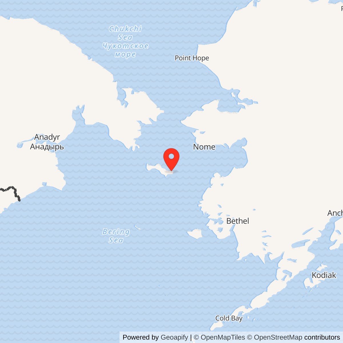
Longitude: -168.956333
Current Role: Former White Alice tract. Alaska DEC lists Site 31 as an active environmental case. Above-ground White Alice structures were removed in 2003. Current parcel-specific ownership and use require verification.
Coordinate note: 63.305306 N, 168.956333 W is an Alaska DEC NAD83 environmental-record reference point for Site 31. It is not a surveyed antenna position, historic parcel boundary, or access point.
- Role
- Four-antenna White Alice tropospheric-scatter relay associated with the separate Northeast Cape radar station.
- Opened
- February 17, 1958, according to the Corps of Engineers station inventory.
- Direct links
- Anvil Mountain and Tin City, each by a pair of 60-foot billboard reflectors.
- Closed
- Traffic ended August 9, 1974; final White Alice personnel left September 18, 1974.
- Present record
- Aboveground plant demolished in 2003; Alaska DEC Site 31 environmental case remains Active.
Identity and setting
The Northeast Cape White Alice Communications Site was a United States Air Force tropospheric-scatter relay on northeastern St. Lawrence Island, Alaska. Its four large antennas and electronics plant were a separate communications facility associated with, but not identical to, Northeast Cape Air Force Station. The radar station detected and reported aircraft; White Alice carried communications across long over-the-horizon radio paths. The Corps of Engineers classified Northeast Cape among the 31 original White Alice stations and among the 14 considered colocated with another defense installation because it shared the radar post's housing, recreation, and other support. Collocation in this administrative sense did not mean the antennas stood in the radar operations building or that the communications compound lacked a distinct footprint. [1] [3] [4]
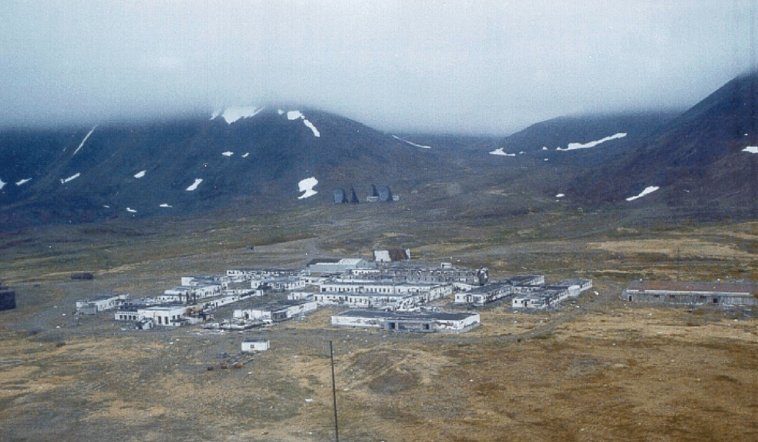
The relay stood southeast and uphill from the Air Force Station's main operations complex, in a glacial valley at the base of Mount Kangukhsam. Alaska's Department of Environmental Conservation (DEC) treats the old relay as Site 31 in the larger Northeast Cape Formerly Used Defense Site (FUDS). DEC places its Site 31 environmental reference point at 63.305306 N, 168.956333 W, NAD83. This is a database location for a contaminated-site record, not a surveyed center of the four antennas, a property corner, or a public access destination. The 2007 proposed plan identifies the former White Alice property obtained by the Navy in 1982 as 26 acres, matching DEC's 26-acre site description. A 2009 Corps decision calls that transfer two acres in one passage. The two-acre figure is an unresolved discrepancy in the decision text, not enough to discard the independently repeated 26-acre description. Neither figure should be added to the former radar base's acreage to produce a sitewide total. [4] [5] [6] [7]
The setting mattered operationally. The old radar base had an airstrip, beach supply route, roads, housing and a mountain tramway. The communications plant could use much of that infrastructure while occupying its own prepared pad uphill from the main cantonment. The Air Force's early station survey, reproduced in its 1983 White Alice sale study, located the communications building roughly 1,600 feet south of the main installation and described a crushed-rock road running from the beach past the main facility toward the tramway. It put the airstrip about a mile from the relay. Such figures describe that survey's period and reference points, not a surveyed present-day legal boundary. The 2007 Corps plan and feasibility study describe the lower tram terminal as Site 32, south of the White Alice compound and at the northern foot of Mount Kangukhsam. The tram was a related support feature and environmental cleanup unit, not another White Alice radio station. [2] [4] [5]
Origins: radar needed a reliable voice and data path
During the early Cold War, the Air Force built a radar screen across Alaska to warn of aircraft approaching across the polar and Bering Sea regions. Northeast Cape's Aircraft Control and Warning station was constructed in 1950 and 1951, and activated in 1952. Its mission was distinct from the subsequent relay's. A detection report could only be useful if controllers and command posts received it promptly and could send instructions back. Ordinary long-distance communications in remote western Alaska were limited, so the Air Force and Corps built White Alice as an interconnected system of microwave and tropospheric-scatter stations. The Corps' 1988 inventory describes the original system as a three-year construction effort undertaken with Western Electric; the Northeast Cape plant was one station in that larger program. [1] [3] [6]
The detailed Corps station profile dates construction at Northeast Cape to 1957 and opening to February 17, 1958. Its 1994 cultural-resources plan gives the same opening date. The 2009 decision document instead says a White Alice station was added in 1954, while also broadly describing a 1952-to-1972 combined radar-and-relay period. Those broad site-history statements conflict with the dedicated station inventory's chronology. They may reflect early communications planning, a pre-White Alice facility, or a simple retrospective error; the reviewed records do not establish which. The date carried here for this particular relay's operational opening is February 17, 1958, not 1954. DEC's phrase that the 26-acre White Alice site operated from 1952 to 1976 similarly conflates or broadens the military property's period and cannot displace the 1958 opening or the Air Force's precise 1974 termination record. [1] [2] [3] [6] [7]
The relay's physical plant
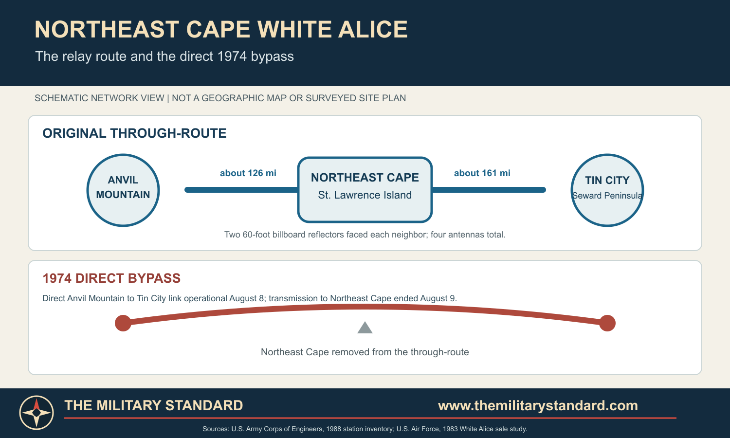
Northeast Cape's original White Alice station had four 60-foot billboard-type antennas. One pair aimed toward Anvil Mountain near Nome and the other pair toward Tin City on the Seward Peninsula. The Corps profile says the Anvil Mountain path was approximately 126 miles and the Tin City path approximately 161 miles. A preliminary station description included in the Air Force's later sale study calls the eastern destination Nome and gives approximately 137 miles; the western endpoint appears as Wales at 161 miles. These are locality names and differing path estimates, not proof of four separate destinations or extra antennas. The physically identifiable relay stations were Anvil Mountain and Tin City. [1] [2]
The term billboard refers to the broad, upright reflecting surface, not to a flat metal wall. The Corps inventory explains that White Alice's large antennas were subtly parabolic, with a feedhorn in front of each reflector. A portion of the UHF radio energy sent toward the horizon scattered through the lower atmosphere and could be received well beyond optical line of sight. The paired antennas on a path provided diversity as propagation changed. The inventory gives a general 10-kilowatt class for 60-foot White Alice reflectors, but the reviewed Northeast Cape records do not identify the exact transmitter model, frequency plan, channel capacity, or measured on-site output at a specific date. White Alice here was a communications system, not an air-search or height-finding radar. [1]
The 1988 Corps profile describes a 5,280-square-foot composite equipment and power building and one 500-barrel POL storage tank for the original facility. The combined building housed radio equipment and standby diesel power in the Air Force's early description. No dedicated White Alice dormitory was constructed because crews used accommodations and recreation at the colocated Air Force Station. The same early description described loose boulders at the relay pad and no permafrost there. These observations are from a period station survey, not a modern geotechnical assessment. [1] [2]
Later environmental inventories describe seven aboveground storage tanks at the White Alice complex, a main electronics building designated Building 1001, other supporting structures, pipelines, and transformer pads. DEC's broader site description counts seven abandoned buildings, four radio antennas, four aboveground tanks, and a tramway. The counts are not identical because the records were compiled at different dates and with different site boundaries and categorization. The single 500-barrel tank in the original historical profile should not be treated as an exhaustive inventory of every later fuel vessel, and the later seven-tank cleanup inventory should not be projected back to 1958. The source set does not support a final reconciled building-and-tank count for each operating year. [1] [4] [6] [7]
How Northeast Cape fitted the network
The western end of the original White Alice network made Northeast Cape a two-path relay between the Alaskan mainland and the Seward Peninsula. Traffic could reach Anvil Mountain near Nome, cross to Northeast Cape on St. Lawrence Island, then continue to Tin City. A path entering the relay had to be received, processed and retransmitted in the appropriate direction; the arrangement was far more than four scenic antennas. Radar-related messages were an original reason to establish the link. White Alice also carried authorized voice and telegraph communications for wider military and civilian users elsewhere in Alaska, but the available station records do not quantify the mix or identify a Northeast Cape-specific commercial subscriber list. [1] [2]
The site's relationship with Anvil Mountain and Tin City is important for interpreting later changes. Northeast Cape was not a terminal that could be switched off without replacing the through-route. Likewise, the nearby radar station's closure did not automatically end the communications relay. Other White Alice locations had switching or multi-route functions, but the reviewed records identify no Alaska Telephone Switching Station 4A switch at Northeast Cape. Its documented role was a two-direction troposcatter repeater serving both its original radar host and onward traffic. [1] [2]
The Corps classified Northeast Cape among original troposcatter facilities rather than the smaller TD-2 microwave-only sites. The full White Alice network later gained long-range missile-warning support routes, Project Stretchout extensions and commercial-overbuild functions. Those network developments explain why operators preserved some links after individual radar missions ended; they do not establish that Northeast Cape itself became a BMEWS switching hub or an independently staffed Air Defense direction center. The site's specific documented network neighbors remained Anvil Mountain and Tin City until a direct bypass took over the traffic. [1] [2]
People, support and isolation
Northeast Cape's airstrip, beach access and annual resupply were essential to the military property as a whole. The 1983 Air Force study's embedded survey says the airstrip was approximately 3,400 feet and required advance Alaskan Air Command approval for its use. Road transport connected the beach, main facility, tramway route and relay. The early survey says operators lived at the Aircraft Control and Warning station rather than at the communications building. It describes the relay as a single building containing equipment and standby diesel generators. The 1988 inventory's absence of a separate White Alice dormitory independently confirms shared support. [1] [2]
The 1994 Corps plan gives the early radar station a 1952 strength of 212 men associated with the 712th Aircraft Control and Warning Squadron and 6980th Security Squadron. That is a wider station figure, not a headcount for White Alice after its 1958 opening. The reviewed station-specific sources do not identify a stable White Alice crew size, shift pattern, or resident Air Force detachment number. The Air Force's 1983 account identifies ITT Arctic Services and the 1931st Communications Group in planning and installing the bypass. It demonstrates contractor and Air Force communications-group involvement, but does not by itself prove that every Northeast Cape operator in every year belonged to those organizations. [2] [3]
The shared living arrangement is more informative than a guessed crew number. It meant a technician could be assigned to keep radio and diesel equipment functioning at a separate pad while relying on a radar-base kitchen, quarters, recreation and transportation. After radar operations ended, keeping the relay alive required maintaining that remote logistics connection for a much smaller residual communications presence. The Air Force study explicitly says White Alice personnel remained until September 1974, years after most radar personnel had left. The source does not give their names or a precise roster. [1] [2] [3]
The radar closing and the 1974 bypass
The radar station's end and White Alice's end are distinct events. The 1994 Corps plan says radar operations ceased in June 1969 and most personnel were removed by the end of that year. The Air Force's 1983 communications history dates the Aircraft Control and Warning site's closure to January 1970, likely an administrative endpoint after the radar mission stopped. That same history states White Alice thereafter served essentially as a repeater. The 1994 Corps plan and 2009 decision summarize White Alice as closed in 1972, but the detailed Air Force operational chronology documents live traffic into August 1974. Thus 1972 can be treated as a general program or regular-service summary, not the last on-air date. [2] [3] [6]
At a December 12, 1973 meeting with Air Force Communications Service leadership, ITT Arctic Services president Lincoln Brown proposed a cost-saving direct Anvil Mountain-to-Tin City troposcatter link. The Air Force study also cites a contractor engineering proposal dated October 10, 1969 and an Air Force comment dated February 12, 1971. Planners considered using existing radio terminals with temporary mobile antennas instead of installing a much larger amount of new equipment to meet an idealized standard. The direct path was marginal, so engineers proposed replacing receiver grounded-grid triode RF amplifiers with parametric or solid-state amplifiers to improve the link's fade margin. This is a documented operational engineering solution, not an assumption that the original Northeast Cape four-antenna site was upgraded in that way. [2]
Air Force Communications Service, Alaskan Command communications staff and the Defense Communications Agency approved the interim plan. The 1931st Communications Group's Scope Creek engineers studied the path. Work Order 74-25CE authorized the temporary Anvil Mountain-Tin City system and work proceeded after a May 28, 1974 notice. A 28-foot MRC-98 antenna at Anvil Mountain blew over during installation; additional anchoring bolts and blocking were then used against wind loading. Test personnel from ITT, Scope Creek and the Defense Communications Agency accepted the usable path. The Air Force expected the temporary link to serve until a planned Nome-Teller-Tin City line-of-sight microwave route became available. The later microwave project should not be confused with the August 1974 temporary tropo bypass. [2]
The direct link went into operation August 8, 1974. The Air Force study dates termination of transmissions to Northeast Cape to 0124Z on August 9. It further records evacuation of all White Alice personnel on September 18, 1974, after which the White Alice service contract portion for Northeast Cape was terminated. The precise dates show a sequence: replacement path accepted, traffic ceased through Northeast Cape, then personnel departed. The Air Force estimated that closing the relay one year earlier than a previous plan could save about $350,000. That figure is a planning estimate, not an audited final saving. [2]
Property and postservice uncertainty
The closed communications plant remained physically standing long after traffic stopped. Both the 1994 plan and the 2009 decision say buildings and much equipment were left because moving them off the island was costly. The 1994 plan describes the facilities as vandalized and decayed and, at that time, scheduled for demolition. Its cultural-resources assessment judged the relay to have lost historic integrity, although the broader White Alice system was discussed as a historic resource. This is a 1994 assessment of condition, not a statement that any antenna survived the subsequent removal work. [3] [6]
Federal sources differ over Navy activity. The 1994 management plan says the White Alice facility was transferred to the Navy in 1982 for submarine-monitoring activities and that the Navy departed some years later. The 2007 proposed plan and 2009 Corps decision also record a 1982 Navy conveyance but say the Navy did not use the property as a communications site; they report that the transfer was later deemed invalid. The property returned to the two St. Lawrence Island Native corporations identified in those reports, Sivuqaq of Gambell and Kukulget of Savoonga, although the 2009 document uses both Savoonga Native Corporation and Kukulget names. A later researcher should not resolve these contradictory federal narratives by asserting a verified Navy communications or submarine-monitoring operation at the White Alice plant. A deed chain and Navy operational records would be required. [3] [5] [6]
The 2007 proposed plan explicitly calls the conveyed White Alice property 26 acres. DEC likewise describes a 26-acre Site 31. The 2009 decision's two-acre sentence appears in a broader site-history paragraph, while the latter document otherwise relies on the earlier feasibility and proposed-plan record for Site 31. This makes 26 acres the stronger working historical acreage, but not an independently surveyed current parcel. The entire Northeast Cape FUDS was about 4,800 acres, a different scale of property. Neither acreage should be described as the area covered by the four antenna foundations alone. [4] [5] [6] [7]
Environmental legacy and cleanup
Environmental investigation at the former military property began in the mid-1980s. DEC's Site 31 record notes a 1986 inspection of abandoned materials, transformers, fuel and other contaminants. A 1990 removal action reportedly took away about 1,000 drums and 29 transformers, but that was a Northeast Cape effort and should not be assigned in its entirety to the White Alice parcel. The Corps undertook phased remedial investigations in 1994, 1996 and 1998, 2001 and 2002, and 2004. Site 31 White Alice and neighboring Site 32 lower tram were treated as separate subareas in the larger remediation program. Local residents and St. Lawrence Island organizations participated in restoration advisory processes and raised concerns about contamination and subsistence resources. These were legitimate matters of community consultation, not proof that every measured impact originated at the relay rather than elsewhere on the wider base. [4] [5] [6] [7]
The 2007 feasibility study describes four antennas, the main electronics building, support structures and seven aboveground tanks in the Site 31 cleanup-era complex. Tanks and pipelines had left localized diesel- and residual-range petroleum contamination. The study reports that soil near the tanks in 2001 contained diesel-range organics from 310 to 3,400 milligrams per kilogram; later pipeline-corridor samples reached 5,400, and one beneath-valve residual-range-organics result reached 11,000. Its 2004 samples found a maximum diesel-range value of 1,280. Surface-water samples collected in 2001 did not identify contaminants of concern. These are sample-specific investigation findings and must not be read as uniform concentrations across the 26-acre property. [4]
The same study found PCBs near transformer pads, west of the main electronics building and at a possible sewage or septic outfall. A 2004 sample reached 14.8 milligrams per kilogram. In 2005 crews excavated 118 tons of PCB-impacted soil from three Site 31 areas: 13 tons at the outfall, 50 tons west of the building and 55 tons beside the former transformer pad. They also removed 79 tons of PCB-contaminated concrete from part of Building 1001's foundation. Two excavation areas met the one-milligram-per-kilogram criterion, but confirmation samples by the transformer pad still measured about 1.53 to 7.09. The 2009 decision selected further excavation and estimated another 110 cubic yards there. The tons removed in 2005 and the cubic yards projected in 2009 are different units and different phases; they cannot be added as though they were a single verified total. [4] [5] [6]
Site 32, the lower tram terminal south of the communications pad, had its own transformer bank, two tanks, well and anchor pit. The Corps found diesel-range organics up to 13,000 milligrams per kilogram in initial sampling and 11,000 in the anchor pit. Its buildings, tanks and tram hardware were removed in 2003 and 2005. The lower tram contamination belongs to the support landscape but should be identified separately from PCB conditions at Site 31. The 2007 feasibility study evaluated no action, land controls, natural attenuation, monitoring, landfarming, phytoremediation, thermal treatment and excavation. It did not select every option it studied. The 2009 decision chose excavation and off-site disposal for contaminated Site 31 and Site 32 soils, with separate PCB action at Site 31. [4] [5] [6]
Demolition of the four reflector antennas, buildings and Site 31 tanks occurred in the 2003 field season. The Corps' 2007 proposed plan includes contemporary images of the antennas being felled and the cleared site. The plan states that building demolition and most structural removal across the former base occurred from 1999 to 2005. The 2009 decision says runway, gravel roads and some concrete foundations survived sitewide. Its Site 31 discussion specifically documented at least portions of the Building 1001 foundation after antenna removal; the existence and condition of a particular pad in 2026 would require a new inspection. The public-domain 1999 Corps photograph shows the former radar cantonment in the foreground and the four White Alice reflectors uphill in the distance. It is a real historical view, not a reconstruction, but the antennas occupy a small part of the original image. [4] [5] [6] [8]
DEC's case remains marked Active in its current public record. That label concerns environmental administration, not active communications service. DEC reports additional 2010 PCB excavation at Sites 13, 21 and 31 together; the combined 1,500-ton figure cannot be apportioned to White Alice without a site-specific removal ledger. DEC approved the final report for major 2014 removal work in 2017 and continued review of sitewide monitoring and land-use controls. A November 2025 entry says two periodic reviews were still being prepared for DEC consideration. The reviewed record does not provide an October 2026 final Site 31 closure letter. Accordingly the history should say the relay is closed and demolished, while the environmental case remains active, without claiming that all contamination has been removed or that current use is unrestricted. [7]
What can be seen and what remains uncertain
The former relay no longer has its distinctive four-billboard skyline. Site plans, demolition photographs, the 1999 Corps view and surviving environmental records are the main public evidence for its layout. The 2007 feasibility study's overall project map places White Alice uphill southeast of the main operations cluster, and its Site 31 maps locate investigated soil areas around Building 1001 and the former tanks. They are remediation maps, not an original 1958 architectural survey. The exact position and azimuth of each of the four antennas should not be reconstructed from a small photograph or a generic White Alice diagram without a station-specific as-built drawing. [4] [5] [8]
Several common errors should be avoided. A page about Northeast Cape radar should not use the 1974 White Alice closure date as its radar inactivation date. Conversely, a White Alice page should not imply the relay ended in 1969 merely because radar crews departed. The White Alice antennas were not radar dishes. The Navy's post-1982 operational role is disputed in official retrospectives. The DEC point is an environmental map marker; at least one widely copied secondary coordinate for Northeast Cape's White Alice plant plots far from the documented compound and is not used here. Finally, the site is part of St. Lawrence Island's lived landscape and cleanup history, not merely an abandoned technical curiosity. [1] [2] [3] [4] [6] [7]
Chronology
- 1950-1952 Northeast Cape's separate Aircraft Control and Warning station was constructed and activated before White Alice.
- 1957 The Corps inventory dates construction of the Northeast Cape White Alice relay to this year.
- 1958-02-17 The Corps dates the four-antenna relay's operational opening to this day.
- 1969-06 The Corps management plan says radar operations at Northeast Cape ceased.
- 1969-1970 The Air Force study describes the radar site closing by January 1970 and the White Alice plant continuing chiefly as a repeater.
- 1972 The Corps' later summary gives this as the end of regular White Alice operation, although detailed Air Force records show traffic continuing until 1974.
- 1973-12-12 ITT Arctic Services presented the Air Force Communications Service with a direct Anvil Mountain-to-Tin City bypass proposal.
- 1974-05-28 A notice to proceed authorized work on the temporary direct troposcatter path.
- 1974-08-08 The direct Anvil Mountain-to-Tin City bypass entered service.
- 1974-08-09 Transmission to Northeast Cape ended at 0124Z, according to the Air Force study.
- 1974-09-18 All remaining White Alice personnel were evacuated from Northeast Cape.
- 1982 A Navy conveyance of the White Alice property was attempted; later Corps records say it was invalid and dispute actual communications use.
- 1985-1986 Environmental assessments and site inspections began identifying abandoned equipment and contamination.
- 1990 A broader Northeast Cape removal action took away drums and transformers; its total is not specific to White Alice alone.
- 1994 The Corps' cultural-resources plan described a vandalized, deteriorating former relay scheduled for demolition.
- 2001-2004 Phased Site 31 sampling investigated petroleum and PCB contamination around tanks, pipes, transformer pads and an outfall.
- 2003 The four billboard antennas, communications buildings and aboveground tanks were demolished and removed.
- 2005 Crews removed 118 tons of PCB-impacted Site 31 soil and 79 tons of contaminated foundation concrete.
- 2007 The feasibility study and proposed plan evaluated remaining Site 31 and lower-tram contaminants and remediation options.
- 2009 The Corps decision selected further excavation and off-site disposal at Site 31 and Site 32.
- 2010 DEC reported a combined PCB-soil removal effort at Sites 13, 21 and 31; it did not provide a White Alice-only tonnage in the site report.
- 2017 DEC approved the final report for the wider site's 2014 major removal program.
- 2025-11-20 DEC reported periodic reviews still in preparation while its Site 31 environmental case remained Active.

Information sources (8)
- PDFU.S. Army Corps of Engineers, Historical Overview and Inventory of the White Alice Communications System, 1988
Source for: the original network classification, Northeast Cape's 1957 construction and 1958 opening, antenna paths, building, fuel and shared support.
- PDFU.S. Air Force, Special Study of the White Alice Communications System Sale, October 1983
Source for: the early site survey, contractor and Air Force communications organizations, 1974 bypass engineering, transmission cutoff and personnel departure.
- PDFU.S. Army Corps of Engineers, The Cold War in Alaska: A Management Plan for Cultural Resources, 1994
Source for: the radar relationship, White Alice opening date, broad closure summary, 1994 condition and differing Navy-use account.
- PDFU.S. Army Corps of Engineers, Northeast Cape Feasibility Study, Final, Volume 1, 2007
Source for: Site 31 and Site 32 layouts, investigations, contaminant results, removal quantities and alternatives considered.
- PDFU.S. Army Corps of Engineers, Proposed Plan for Northeast Cape Air Force Station FUDS, July 2007
Source for: the 26-acre attempted Navy property transfer, photographs, community-facing cleanup summary and site-specific risk explanation.
- PDFU.S. Army Corps of Engineers, Northeast Cape FUDS HTRW Decision Document, January 2009
Source for: the selected remedies, Site 31 demolition and residual contamination, later property summary and sitewide remaining structures.
- WEBAlaska Department of Environmental Conservation, St. Lawrence Northeast Cape Site 31 White Alice case record
Source for: the NAD83 environmental point, 26-acre record, continuing case status and post-2009 restoration chronology.
- WEBU.S. Army Corps of Engineers, White Alice Site on St. Lawrence Island photograph, 1999, via Wikimedia Commons
Source for: photographic confirmation of the separate uphill reflector array behind Northeast Cape's main cantonment; image marked public domain on its file page.