
Anvil Mountain White Alice Communications Site, Alaska
Longitude: -165.371519
Current Role: Former communications site near Nome; Alaska DEC records cleanup complete. Present antenna survival, title, access and reuse require a current property and field check.
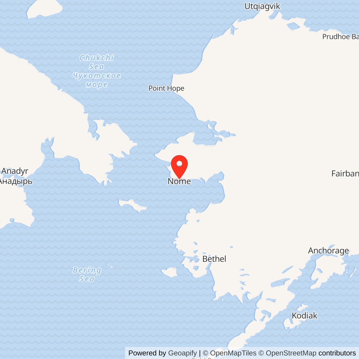
Location: Approximately 6.5 miles north of Nome. Alaska DEC case marker: 64.563611 N, 165.371519 W (WGS84). This is not a surveyed antenna point or property boundary.
- Role
- White Alice tropospheric-scatter communications relay, not a radar station.
- Operation
- Opened January 9, 1958; deactivated in 1978.
- Original paths
- Granite Mountain, about 136 miles; Northeast Cape, about 126 miles.
- Later change
- Temporary 30-foot dish link to Tin City bypassed Northeast Cape in the mid-1970s.
- Landmark
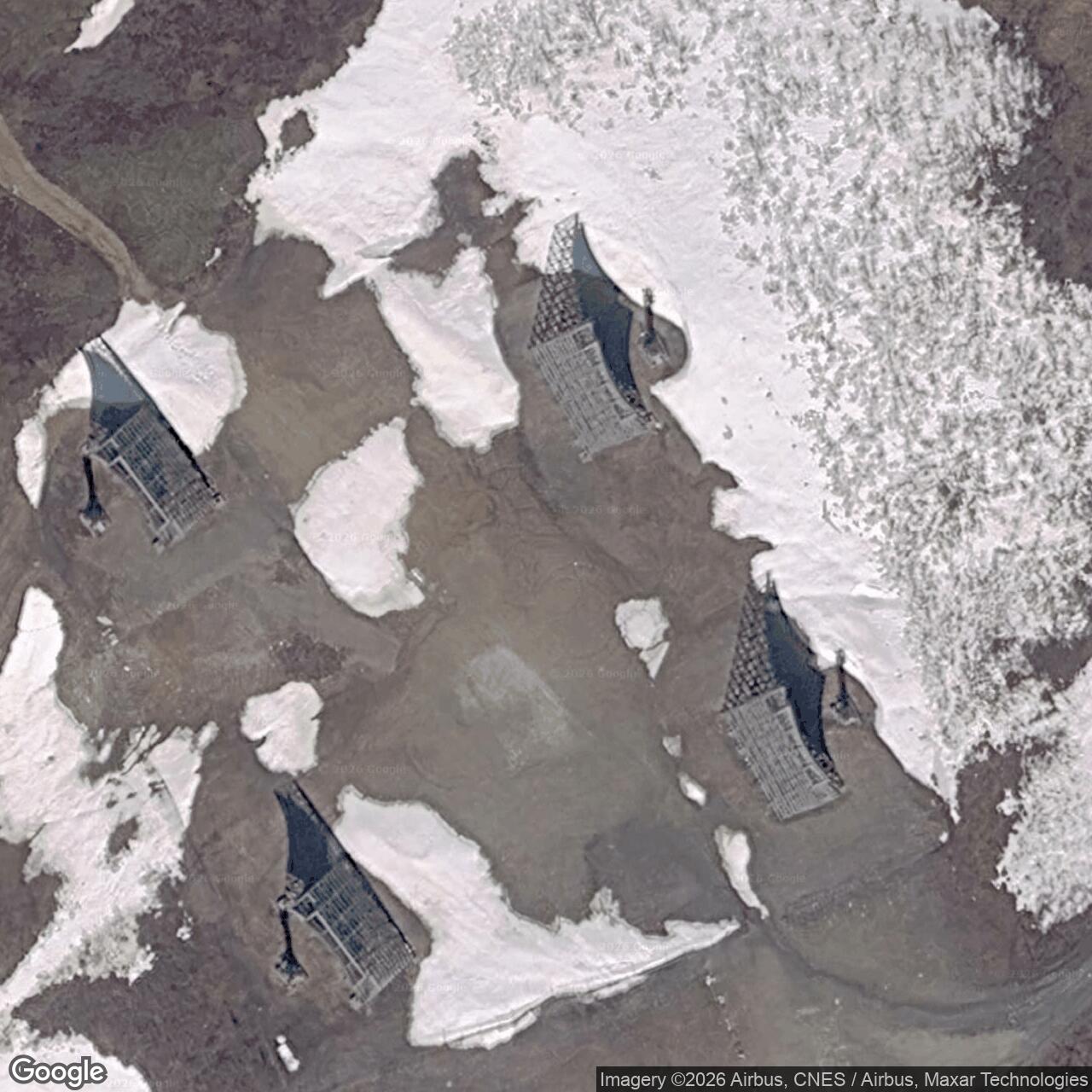
- Four antennas were documented as a Nome landmark in 2023; current structural condition needs a field check. Follow the landholder's posted access rules.
Identity, location and historical role
Anvil Mountain White Alice Communications Site was a U.S. Air Force long-distance radio relay on a mountain north of Nome, Alaska. Its principal historical function was to carry messages across the Seward Peninsula and Bering Sea region, including communications needed by Alaska's aircraft-control and warning network. The site was not an air-defense radar station and had no documented search or height-finding radar mission of its own. Its enormous paired reflectors could look superficially like radar antennas, but they pointed at fixed remote relay stations. They transmitted and received communications instead of scanning for aircraft. The U.S. Army Corps of Engineers identified Anvil Mountain as one of the original White Alice stations and documented its initial links to Granite Mountain and Northeast Cape on St. Lawrence Island. [1] [2]
The Alaska Department of Environmental Conservation (DEC) locates its Anvil Mountain White Alice cleanup case at 64.563611 N, 165.371519 W, WGS84, about 6.5 miles north of Nome. Those decimal coordinates are a case-location marker. They should not be presented as a surveyed antenna center, a parcel centroid, or the boundary of the old station. A 2010 Air Force public notice described an approximately 11.74-acre tract withdrawn from the public domain for the radio relay station in Section 1, Township 11 South, Range 34 West, Kateel River Meridian. The notice defined the area closed for cleanup at that time, not necessarily every historic cable, road or utility interest and not present title. The mountain also contains or has contained other named communications and weather-related activities. The similar name Anvil Mountain AWS in federal contaminated-lands material has not been demonstrated to be the same installation and is not folded into this White Alice record. [3] [4] [5]
Why Nome needed a relay
Alaska's early-warning problem was more than the detection of an aircraft. Reports from remote radar stations had to reach control centers, airfields and other stations quickly enough to be useful. The country's northern defenses spread across terrain where building and maintaining ordinary wires was costly and where high-frequency radio could be disturbed by auroral and atmospheric conditions. The Corps' 1988 history says that before White Alice, only one telephone call at a time could pass between Fairbanks and Nome. That description conveys the narrow bandwidth available to a community and defense network with growing demands. The 1954 Alaska Communications Study Group sought a more dependable, higher-capacity solution; the Bell System recommended long tropospheric-scatter paths with smaller line-of-sight microwave links where terrain and road access made those practical. Western Electric received the White Alice contract in 1955. The Corps surveyed and contracted for part of the original network, while Western Electric installed electronics throughout the system. The source does not identify which contractor built Anvil Mountain's particular structure, so this history does not assign its construction to one company without a contract or as-built record. [1]
Tropospheric scatter uses a very powerful, narrowly aimed signal and a small portion scattered through the lower atmosphere to reach beyond the normal radio horizon. In White Alice service, paired reflectors provided a path toward the next station, and the equipment building housed the transmitters, receivers, power plant and supporting apparatus. The large structures were often called billboards because their steel reflector surfaces appeared nearly flat from some angles. The Corps' technical description emphasizes that they were actually parabolic. A feedhorn stood out in front of the reflecting surface. That geometry matters when identifying or illustrating the surviving Anvil Mountain antennas: they were not flat signs, ordinary satellite dishes or radar search arrays. [1] [2]
Construction and opening
The Corps' 1988 station inventory says Anvil Mountain was constructed in 1957 and opened on January 9, 1958. Its 1994 Cold War cultural-resources plan says construction began in 1957 and was completed in January 1958. A 2023 City of Nome document also identifies the operating period as 1958 through 1978 on the strength of the Corps work. The exact January 9 opening in the earlier inventory is therefore the best available site-specific milestone. It should not be confused with the network-wide Elmendorf ceremony of March 26, 1958, nor with completion of all original White Alice links in 1959. A network can begin using a specific station before every planned station and circuit is finished. [1] [2] [6]
The Air Force chose a summit near a populated town rather than an isolated camp. The principal station structure was a 6,720-square-foot equipment and power building. The 1994 Corps description calls it wood framed and clad with asbestos-cement shingles. No separate dormitory was built because operators could live in Nome. This arrangement distinguished Anvil Mountain from the more remote White Alice relay camps, which needed attached or separate dormitories, messes, water systems and larger support areas. It still required a reliable mountain road, electrical generation and on-site fuel. The 1988 inventory lists one petroleum, oil and lubricants tank with a capacity of 1,600 barrels, approximately 67,200 U.S. gallons. That is an inventory-era capacity figure, not proof that every later environmental tank record refers to the same single vessel. [1] [2]
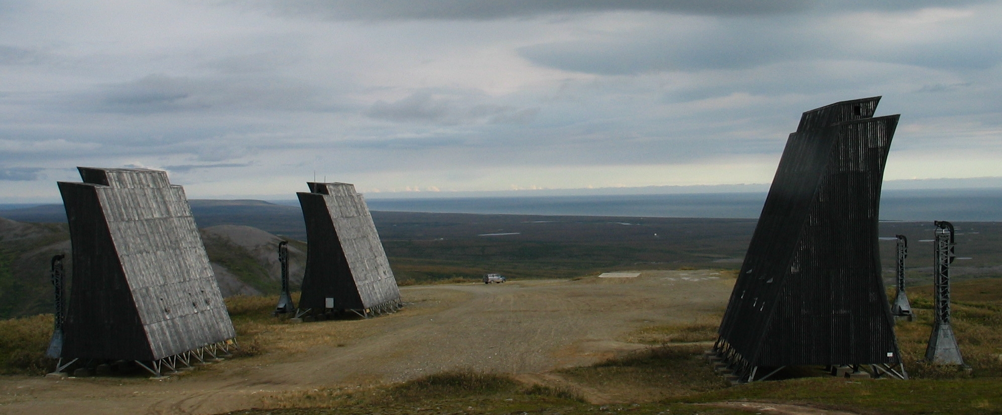
The original antenna field had two pairs of 60-foot tropospheric billboards. One pair faced Northeast Cape, approximately 126 miles away on St. Lawrence Island; the other faced Granite Mountain, approximately 136 miles away. These are historical radio-path distances, not travel distances or a basis for locating the exact foundations from a modern map. The Corps says paired tropo antennas were aimed with slightly different placements to improve reception under variable propagation conditions. The reflectors, feedhorns, transmission equipment and power supply formed one communications plant. A photograph of the antennas alone cannot identify the model of every transmitter, receiver, generator or switch that operated inside. No Anvil-specific equipment roster or year-by-year maintenance log has been verified, so those model names are not invented from generic White Alice descriptions. [1] [2]
Routes and change during service
In its first configuration, Anvil Mountain stood between Granite Mountain and Northeast Cape. Northeast Cape had both an aircraft-warning station and a distinct White Alice communications facility; the radio relay and radar operations should not be merged simply because they served the same defense system. Anvil Mountain's task was to carry circuits onward, not to direct aircraft or operate the Northeast Cape radar. The distant Granite Mountain terminal was another independent relay. Linking the three as a communications chain helps explain Anvil Mountain's strategic role without giving it ownership or personnel responsibility for those other sites. [1] [2]
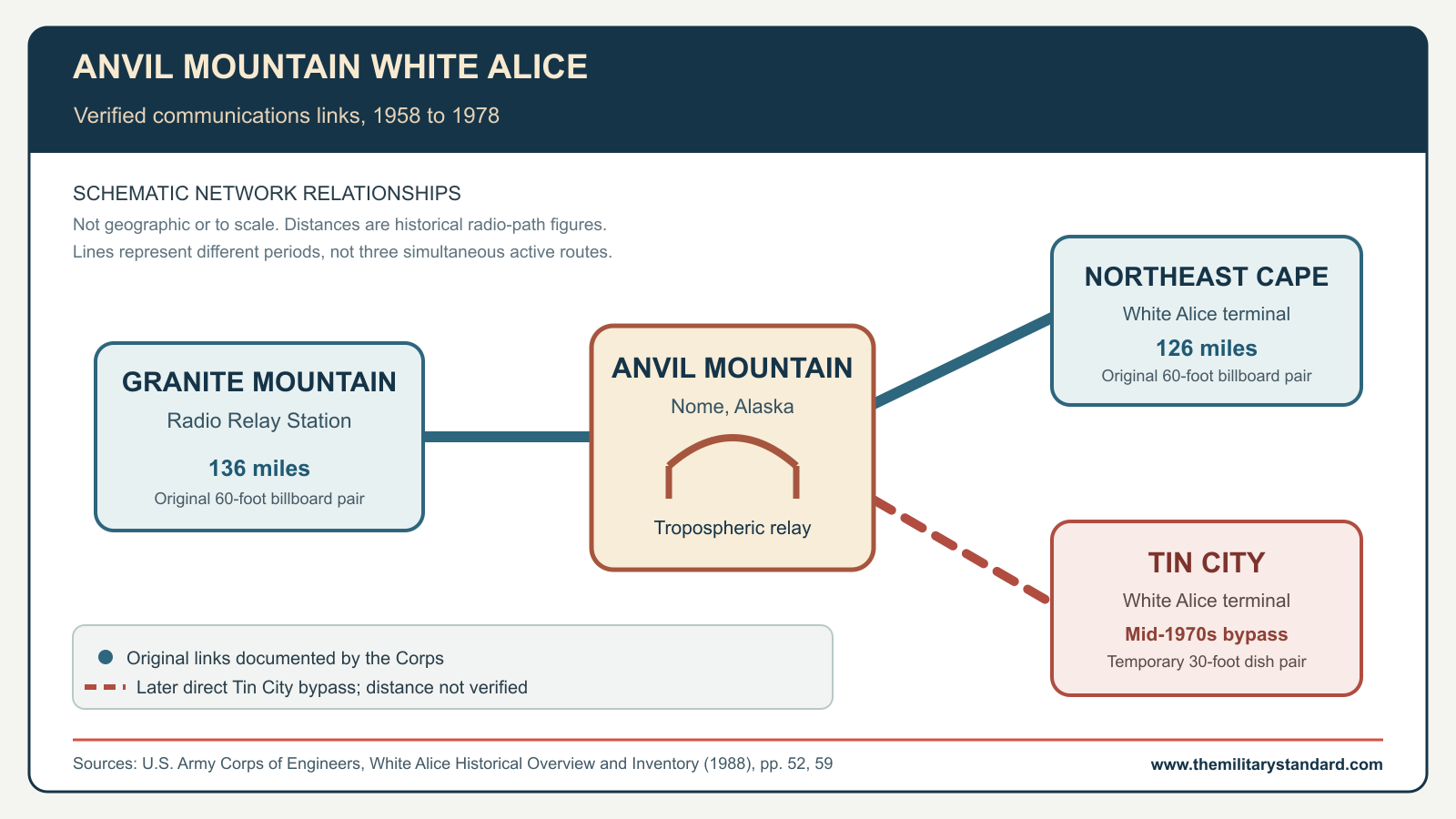
The route changed as equipment, defense requirements and other sites changed. The 1988 Corps inventory states that a pair of transportable 30-foot dishes was added at Anvil Mountain in the mid-1970s to bypass the Northeast Cape link. Crucially, the same report's Tin City entry identifies the temporary 30-foot Anvil Mountain to Tin City connection. This confirms the direct bypass rather than merely suggesting it from two antennas visible in a photograph. The Tin City White Alice terminal was about 1.5 miles from Tin City Air Force Station, so the communications terminal and radar station are separate physical facilities even though they share a place name. The source does not supply a commissioning date, circuit number, complete route diagram or exact shutdown date for the bypass, so "mid-1970s" is the appropriate precision. The two original 60-foot pairs and the later 30-foot dishes should not be presented as one unchanging 1958 configuration. [1]
White Alice also supported civilian communications. By extending dependable telephone and telegraph capacity, the system connected communities that previously relied on limited long-distance circuits. The system's later operation under RCA Alaska/Alascom and the advent of satellite service changed the economics of those long-distance links. The Corps' 1994 plan says Alascom began operating White Alice in 1970; other legal and technical transitions were not necessarily simultaneous at every station. The source record reviewed for Anvil Mountain does not establish exact dates for each commercial circuit cutover. Local recollections printed in the Nome Nugget underline the link between Nome households and the mountain station, but recollection is not a technical traffic log. [1] [2] [7]
People and daily operation
Anvil Mountain was unusually close to town for a White Alice tropo station. Personnel lived in Nome and traveled uphill rather than occupying a station dormitory. That saved the expense and physical footprint of a self-contained residential compound, but it did not eliminate the problems of winter travel, fuel delivery, standby generation and maintenance in a harsh climate. The White Alice system depended on technicians capable of keeping sensitive communications equipment aligned and powered. A local 2010 account identifies Stan Harhut as a longtime Anvil Mountain supervisor. He recalled a usual staff of about ten, including technicians, mechanics, power-plant workers, snow-removal staff and a janitor. That is retrospective testimony, not an annual staffing table. The same account describes severe winter work, the need to keep the uphill road clear and the improvisation sometimes needed to maintain vehicles. Harhut said he had worked at the station from the construction period through 1978, but the published interview does not establish an official appointment for every year of that span. No site-level squadron or year-by-year contractor roster has been substantiated for Anvil Mountain. [1] [2] [7]
The mountain's proximity to Nome also shaped the station's material history. Workers and equipment could reach a road-served summit from town, unlike relay sites supplied by air or sea. Yet the 1,600-barrel fuel inventory makes clear that electrical self-sufficiency was a substantial part of the installation. The wood-framed equipment building, petroleum storage and large steel reflectors left a significant physical and environmental footprint after the radio traffic stopped. What survived in photographs and what remained in an environmental record are different kinds of evidence: the former shows structures, while the latter tracks contamination and cleanup boundaries. Neither alone establishes a complete as-built layout. [1] [2] [3]
Shutdown and a changing physical site
The Corps dates Anvil Mountain's White Alice deactivation to 1978. DEC's case narrative uses 1979 as the excess declaration, a related but different administrative event. It also contains a broad "1944 to 1980" site-use line that cannot be interpreted as the operation of a White Alice station built in 1957. The dates are therefore not a single contradictory service interval. January 9, 1958 to 1978 is the documented relay period; 1979 concerns excess property status, and later years concern inspection, cleanup and ownership. A precise final on-air day or a signed last-circuit order has not been located. [1] [2] [3]
When the Corps prepared its 1994 plan, the station's operations building was abandoned and boarded up, while much of the installation was still physically intact and showed limited vandalism. The Corps assigned the Anvil Mountain site Alaska Heritage Resources Survey number NOM-099 and a high preservation-priority category because demolition was under review. Its general statement that the White Alice system was National Register listed must not be inflated into a claim that the Anvil Mountain property was individually listed. The report recommended retention of at least one White Alice station and identified Granite Mountain, not Anvil Mountain, as its preferred complete station for new use. Anvil's own later preservation story came to focus on the four monumental antennas rather than an intact operating complex. [2]
DEC's environmental chronology says buildings had been demolished by November 1999, while a concrete foundation slab still needed disposal work. That documented building demolition is more precise than a simple claim that the whole station was demolished: four billboard reflectors survived. A 2011 Air Force article, written during work at Bethel, identified the four Anvil Mountain antennas as the remaining Air Force White Alice billboards in Alaska at that time and reported that Sitnasuak Native Corporation, then a prospective future landowner, wanted them retained. The article also said asbestos-bearing material had to be removed before transfer. It describes a planned condition and a dated 2011 ownership situation, not a present-day title certificate. [3] [8]
Contamination, decisions and cleanup
The abandoned station raised concerns about polychlorinated biphenyls (PCBs), petroleum residues, debris and asbestos-containing material. DEC's 1981 preliminary assessment reported contaminated transformers, stored acids and other material, followed by PCB removal to Elmendorf in 1982. Later inspection and the Corps' 1993 site investigation led to additional characterization. A 1996 report confirmed diesel-range and residual-range petroleum organics and PCBs in soil; a suspected lead area was not confirmed. Work in the late 1990s addressed petroleum-contaminated soil and building demolition, but DEC did not treat that as final closure because PCB-affected soil and foundation material remained. Its case record describes contaminated soil moved around by vandalism and grading, an important reason why later investigators had to look beyond a few obvious equipment locations. [3]
The investigation continued in 2004 and 2005. DEC reported PCB detections above its 1 milligram per kilogram action level in several areas, with a maximum of 49.3 milligrams per kilogram in the focused study. A larger 2009 investigation used 343 screening and 60 confirmatory analytical samples and estimated approximately 3,854 cubic yards of soil above 1 milligram per kilogram. These are the volumes and measurements reported at specific stages of characterization; they are not a claim that exactly that volume was ultimately shipped away. The adopted remedy segregated material by particle size and required off-site disposal of soil remaining above the 1 milligram per kilogram PCB cleanup level. The Air Force and DEC signed the record of decision on May 3 and May 6, 2010, respectively. A contemporary Air Force notice fenced the 11.74-acre cleanup tract and restricted public access to the work site while remediation proceeded. [3] [4]
Cleanup and sampling extended into 2011 and 2012. DEC's May 6, 2014 entry says the remedial action report demonstrated removal of PCB soil above the record-of-decision threshold and issued a cleanup-complete determination for its case. DEC currently lists no institutional controls for this case, but it requires advance approval before soil or groundwater is transported off-site. A 2023 assessment found no identified aqueous film-forming foam source at Anvil Mountain; DEC expressly left evaluation of possible non-AFFF PFAS sources for separate work. "Cleanup complete" is the regulator's disposition of the investigated case, not a promise of zero residual contaminants or a substitute for current access and safety rules. [3]
Preservation and current interpretation
The 2005 photographs in this package show the distinctive four-billboard skyline after the operational building was gone. They are not photographs of an active relay. Their surviving steel framework and reflector faces make Anvil Mountain a rare place where visitors can still recognize White Alice's physical form, but a dated photograph cannot certify today's structural condition. An Alaska Department of Fish and Game visitor page identifies land on Anvil Mountain as Sitnasuak Native Corporation property and directs visitors to obey posted rules. That page is guidance, not a surveyed title report. The 2011 Air Force article described Sitnasuak as a prospective owner then interested in preservation; these dated statements do not constitute a present title instrument. [8] [9] [10] [11]
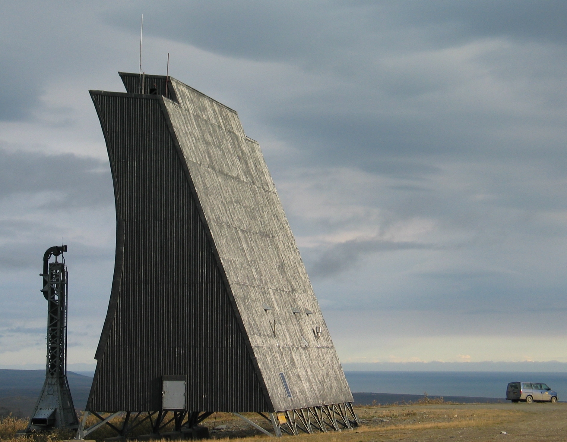
The City of Nome's 2023 Port Commission material describes the White Alice antennas as a landmark and navigational aid dominating the city's skyline. The relay's functional life was two decades, yet its visual presence outlasted the communications technology that made it possible. For Nome, the structures are therefore both Cold War engineering artifacts and part of a local landscape. Their survival should not obscure that the principal wood-frame building and much of the working plant were demolished. Conversely, demolition of those buildings should not be reported as destruction of the entire station. The remaining four reflectors represent the original 60-foot long-distance antenna pairs, while the temporary 30-foot bypass dishes are no longer an evident part of the preserved skyline. [1] [3] [6] [8] [9] [10]
Research limits and interpretation
This history distinguishes five different levels of evidence. The Corps gives specific station construction, opening, route, building and deactivation facts. The DEC file gives environmental investigations and regulatory decisions, not a complete operating log. Air Force and City accounts document later preservation context at their respective dates. Historic photographs show visible structures in 2005. General White Alice technical descriptions explain how a tropo relay worked but do not establish the exact manufacturer, model, power rating or service date of every Anvil cabinet. Those details, along with annual staffing, final circuit orders, the complete property chain and the precise survival condition of each reflector in 2026, need original station records or a new field/title study. The unknowns are not filled with plausible equipment borrowed from other relay stations. [1] [2] [3] [6] [8]
Anvil Mountain's significance rests in the relationship of a remote defense network to an actual community. Its link paths reached independent stations across difficult terrain and water; its people could live in Nome; its equipment footprint remained visible and required cleanup long after satellite communications superseded the original circuits. The four surviving billboards let the public see a characteristic piece of the system without treating a preserved landmark as a functioning installation. [1] [2] [3] [6]
Chronology
- 1954 The Alaska Communications Study Group seeks a more reliable long-distance communications system for the state's defense network.
- 1955 Western Electric receives the original White Alice system contract.
- 1957 Construction begins at the Anvil Mountain tropospheric relay near Nome.
- 1958-01-09 The Corps' historical inventory records Anvil Mountain opening.
- 1958-03-26 The original White Alice network is publicly inaugurated at Elmendorf, a network milestone distinct from Anvil Mountain's January opening.
- 1970 The Corps' later history dates Alascom's start of White Alice operation at system level; an Anvil-specific legal cutover date is not established.
- Mid-1970s A temporary pair of 30-foot dishes is added to connect Anvil Mountain with Tin City and bypass the Northeast Cape route.
- 1978 The Corps dates Anvil Mountain's relay deactivation to this year; the final on-air day is not verified.
- 1979 DEC's environmental case says the former White Alice property is declared excess.
- 1981 A preliminary assessment identifies PCB-containing and other hazardous material at the abandoned site.
- 1982 PCB material is removed for storage at Elmendorf pending disposal.
- 1993 The Corps' preliminary assessment and site investigation lead to further DEC review.
- 1994 The Corps describes the boarded-up station as largely intact and assigns high preservation priority and AHRS number NOM-099.
- 1999 DEC records that station buildings have been demolished, with additional concrete and PCB soil work still needed.
- 2004-2005 Focused sampling delineates remaining PCB contamination; a later report gives a maximum of 49.3 milligrams per kilogram.
- 2009 Broader investigation estimates roughly 3,854 cubic yards of soil above 1 milligram per kilogram PCB.
- 2010-05-03 to 2010-05-06 The Air Force and DEC sign the cleanup record of decision.
- 2010-2011 The Air Force undertakes fenced soil removal, segregation and off-site disposal work.
- 2011 An Air Force article reports four Anvil Mountain billboard antennas retained for prospective local preservation.
- 2014-05-06 DEC issues a cleanup-complete determination for its Anvil Mountain case.
- 2023 City of Nome materials describe the antennas as a historical marker and navigational aid; DEC's AFFF assessment finds no identified AFFF source but leaves other PFAS evaluation separate.
Information sources (11)
- PDFWhite Alice Communications System: Historical Overview and Inventory, U.S. Army Corps of Engineers, Alaska District, 1988
Source for: system context, Anvil construction and January 9, 1958 opening, station facilities and route distances, later Tin City bypass, 1978 deactivation and technical description of tropospheric reflectors. Local copy supplied by the user; relevant PDF pages 9, 13-15, 23, 59 and 66.
- PDFThe Cold War in Alaska: A Management Plan for Cultural Resources, U.S. Army Corps of Engineers, Alaska District, 1994
Source for: standard station context, Alascom transition, Anvil building material and 1994 condition, preservation assessment and AHRS number NOM-099. Local copy supplied by the user; relevant PDF pages 228-236.
- WEBAnvil Mt. White Alice Site, Hazard ID 844, Alaska Department of Environmental Conservation
Source for: WGS84 case-location point, excess-property notation, demolition and environmental chronology, 2010 record of decision, 2014 cleanup-complete determination and 2023 AFFF assessment.
- PDFPublic Announcement for Nome Residents and Visitors, U.S. Air Force, printed in The Nome Nugget, July 15, 2010, page 12
Source for: 11.74-acre historical withdrawn-land cleanup tract, legal land description and temporary access closure during remediation.
- PDFAlaska Contaminated Lands Report to Congress, Bureau of Land Management, 2016
Source for: caution that generalized FUDS names and points do not establish parcel relationships; distinct Anvil Mountain AWS identity lead.
- PDFNome Port Commission regular meeting packet, City of Nome, June 22, 2023
Source for: independent City account of Anvil Mountain's 1957 construction, 1958-1978 use and continuing skyline, historical-marker and navigational-aid significance.
- PDFNome memories from longtime Anvil Mountain supervisor, The Nome Nugget, July 15, 2010
Source for: local operating recollection and staff travel from Nome, treated as oral testimony rather than a complete staffing record.
- WEBCold War era White Alice Communication System antenna felled for a clean and safe dismantling, Joint Base Elmendorf-Richardson, September 16, 2011
Source for: four Anvil antennas remaining in 2011, planned Sitnasuak preservation and asbestos removal prerequisite; Bethel demolition in the same article is not Anvil demolition.
- WEBTeller Highway Mile 0-7: Anvil Mountain and White Alice Antennas, Alaska Department of Fish and Game
Source for: visitor interpretation of the four antennas and Sitnasuak property/access caution. Publication date not established, so no present-day structural inspection is inferred.
- WEBNome Alaska White Alice Tropo Antennae, photograph by Chris Lott, August 25, 2005, Wikimedia Commons, CC BY 2.0
Source for: authenticated 2005 view of four surviving Anvil Mountain billboards and photo-use terms.
- WEBNome Alaska White Alice Tropo Antenna, photograph by Chris Lott, August 25, 2005, Wikimedia Commons, CC BY 2.0
Source for: authenticated 2005 close view of a reflector and support structure and photo-use terms.