
Tin City White Alice Communications Site, Alaska
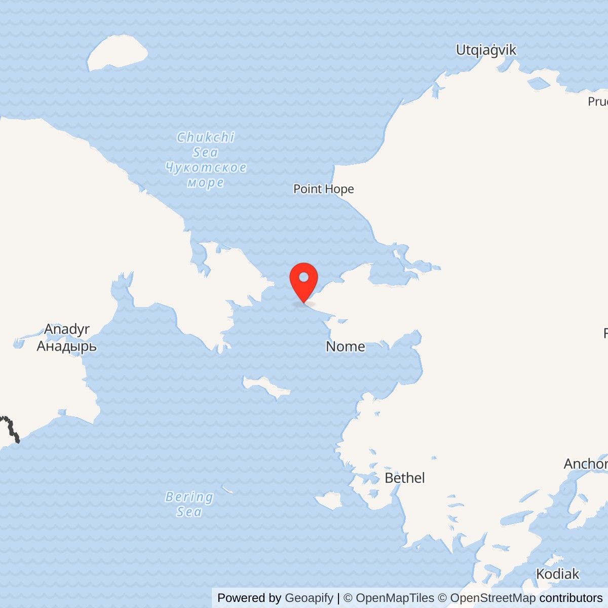
Longitude: -167.94302
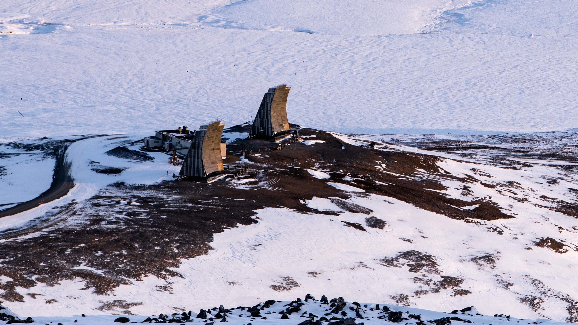
Current Role: Former relay and later Navy-associated site. Alaska DEC lists its White Alice environmental case cleanup complete since 2005-11-14. An inspected 2018 DoD photo shows at least two upright reflector structures.
Coordinate label: Alaska DEC NAD83 cleanup-case point, not a surveyed antenna center, property centroid, or radar station coordinate. 65.583583 N, 167.943020 W.
- Mission
- Air Force long-distance communications relay for the Tin City radar station, not a radar installation.
- Service
- February 18, 1958 to February 1975.
- Original path
- Approximately 161 miles to Northeast Cape, with 60-foot reflectors.
- 1974 change
- Direct temporary Anvil Mountain bypass activated August 8, 1974.
- Footprint
- 6.3-acre DEC cleanup case; not a surveyed historic property boundary.
Overview
Tin City White Alice Communications Site was an Air Force relay terminal near the Bering Strait, physically separate from Tin City Air Force Station's radar. It opened on February 18, 1958 and operated through February 1975. Its original 161-mile tropospheric-scatter path reached Northeast Cape on St. Lawrence Island. A temporary direct path to Anvil Mountain near Nome replaced the Northeast Cape route in August 1974, just before commercial microwave service and, later, a Tin City satellite terminal took over the broader communications task. The White Alice antennas carried information; they were not search or height-finding radars. [1] [2] [3] [4]
Tin City's geography made the relay particularly important. The radar station faced the Soviet Far East from Cape Mountain, but detection had little military use unless warnings, control messages, administrative traffic, and technical reports could move reliably across Alaska. High-frequency radio had proven erratic. White Alice gave the radar a dedicated, engineered route into the larger network, initially by crossing the open water to St. Lawrence Island. The terminal's history is therefore a history of communications infrastructure that allowed an isolated radar station to act as part of an air-defense system. [2] [3]
Location and Distinct Identity
The Alaska Department of Environmental Conservation records a NAD83 case point at 65.583583 N, 167.943020 W for the former White Alice area. This is a regulatory location marker, not an antenna survey point or surveyed property centroid. DEC describes the site as about one mile north of the long-range radar facilities and roughly 7,000 feet northeast of the Tin City airfield. The Corps gives an approximate 1.5-mile separation from the AC&W station, likely using a different reference point. [1] [2] [5]
The Corps' White Alice inventory describes a 4,960-square-foot composite building and two petroleum tanks with a combined 950-barrel capacity. It says personnel lived and ate at the adjacent AC&W station. The relay nonetheless had its own antenna field, power and fuel needs, communications electronics, access route, and later environmental case. Sharing support with the radar did not make White Alice part of the radar's antenna system. [1] [2]
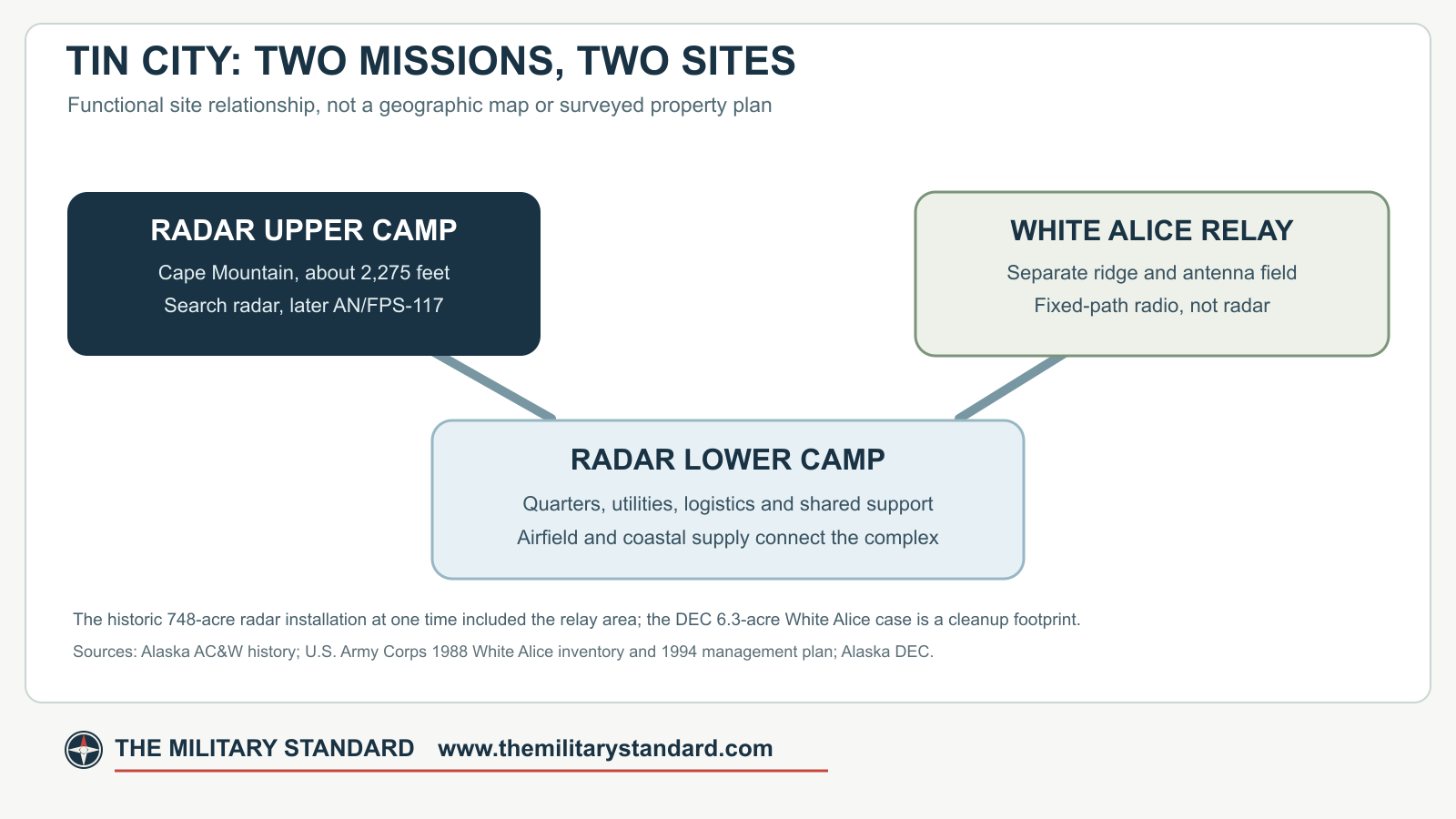
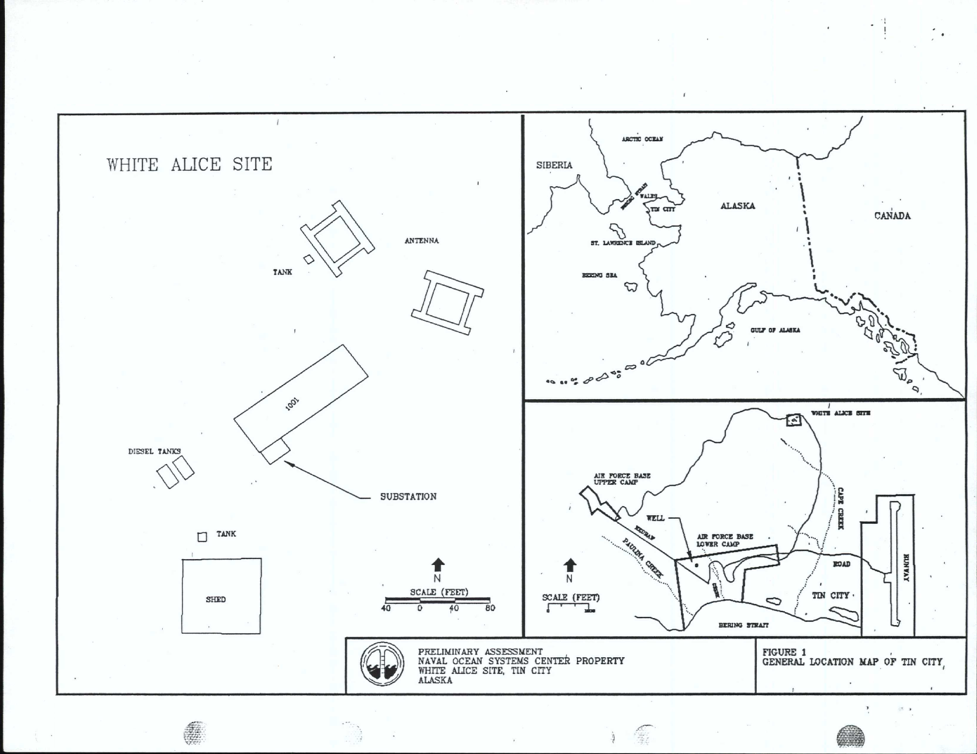
The Navy's 1991 preliminary assessment describes a 6.3-acre White Alice property and identifies two abandoned buildings, four radio antennas, and four fuel tanks as then present. Its site plan distinguishes the main building, separate shed, antenna positions, tanks, the radar camps, and the airfield. The 6.3-acre figure should not be expanded to include every historical cable, tramway, or access interest. Likewise, the radar installation's historic 748-acre figure is an installation-wide administrative total that at one time included the White Alice area, not an acreage to add to the 6.3 acres. [3] [5] [8]
Why White Alice Was Built
The Air Force's original Alaska AC&W network had to operate over mountainous, sparsely settled terrain with severe weather and few conventional communications lines. Ordinary line-of-sight microwave could bridge shorter paths but not every coastal and water crossing. White Alice used tropospheric scatter on longer paths: a powerful, narrow radio beam was aimed toward the lower atmosphere, and a small scattered portion of the signal reached a distant receiving terminal beyond the geometric horizon. Large paired antennas and substantial supporting power made the technique practical. [1] [3]
Tin City needed such a path because of its western warning role. The AC&W station was fully operational by April 1953, several years before White Alice opened. Early high-frequency radio links suffered from unreliable propagation. The later relay did not improve the radar's ability to illuminate an aircraft; it improved the means by which the radar's observations and command traffic could reach the regional system. This distinction is also visible in the hardware: Tin City's White Alice billboards were fixed communications reflectors, whereas the radar station used search radars at a different location. [2] [3]
The wider White Alice route tied Tin City to Northeast Cape and, through another documented Northeast Cape path, to Anvil Mountain. The original Tin City to Northeast Cape path measured about 161 miles and used 60-foot reflectors. Northeast Cape's other principal route to Anvil Mountain measured about 126 miles. This describes the physical radio links, not a claim that every particular radar report followed one fixed sequence or that there were no alternative voice circuits. [1]
Construction and Opening
The Corps inventory dates White Alice terminal construction to 1957 and records its first communications on February 18, 1958, a site-specific opening date repeated in the 1994 Corps management study. A 1991 Navy retrospective instead dates work at this location to 1952-1954 and describes communications operation beginning in 1954. The earlier account may reflect a predecessor facility or a different definition of operation; the record does not establish that the documented 161-mile White Alice route was transmitting in 1954. February 18, 1958 remains the best-supported date for that route's first traffic. This is distinct from the radar station's 1953 opening and the relay's later 1974 route change and 1975 closure. [1] [2] [8]
The composite building concentrated technical and support functions in a weather-protected structure. The paired 60-foot-class reflector installation supported the long over-water path. Fuel storage served the relay's power needs. Remote access and wind exposure complicated construction and maintenance; a passenger tramway was added in 1963 to move workers between base camp and the upper White Alice area. The Corps combines Tin City and Cape Lisburne tramway construction in a cost figure approaching $1.4 million, so that total should not be assigned to Tin City alone. [1] [2]
The same inventory records substantial composite-building repairs during 1967 and 1968, reporting $4.6 million. It does not itemize all work behind the amount in the accessible summary. The number establishes that repair was a serious program, but not a cost breakdown of antennas, electronics, fuel equipment, or labor. It is separate from the original 1950-1952 radar-station construction cost. [1]
Operating the Long Path
The original paired White Alice antennas pointed toward Northeast Cape. Their fixed geometry gave the terminal its distinctive appearance. Although commonly called billboards, the reflectors were engineered curved surfaces, not flat panels or rotating radar dishes. A 2018 Defense Department photograph of the abandoned ridge shows two upright curved structures. [1] [6]
White Alice required more than antennas. Transmitters, receivers, waveguides, power systems, environmental controls, fuel, monitoring, and technicians all had to work together. Tin City's AC&W station furnished practical support, including living and eating facilities. The Navy's later history gives a seven-to-twelve-person civilian and contractor complement, accommodated at the radar camp about a mile away. Specific Tin City transmitter designations and traffic volumes remain undocumented. The long-distance route, rather than a particular model of electronics, defines the terminal's verified mission. [1] [2] [8]
Northeast Cape was on St. Lawrence Island, remote from Tin City but directly across the Bering Sea route. Its radar station and its White Alice terminal were also separate installations. When Northeast Cape radar service ended in 1969-1970, planners considered bypassing its communications relay. A 1969 proposal examined a direct Tin City to Anvil Mountain route; later analyses looked for a less expensive way to achieve it. [1] [4]
The 1974 Anvil Mountain Bypass
The 1931st Communications Group's 1983 study supplies a much more exact sequence than the later site summaries. A 1971 proposal favored using existing facilities and mobile 30-foot antennas. Work order 74-25CE followed, with a notice to proceed on May 28, 1974. The route paired Tin City with Anvil Mountain, avoiding the intermediate Northeast Cape link. One temporary antenna at Anvil Mountain was initially blown over and required reinforcement, a reminder that atmospheric propagation was not the only Arctic engineering problem. [4]
The direct temporary tropospheric-scatter route became operational on August 8, 1974. The Northeast Cape path was taken out of service at 0124Z on August 9. Personnel associated with the old route left Northeast Cape by September 18. The change was thus a 1974 reconfiguration of the White Alice network, not evidence that the original 1958 Tin City antennas had always pointed toward Nome. The 30-foot temporary circular antennas were different from the original 60-foot Northeast Cape reflectors. [1] [4]
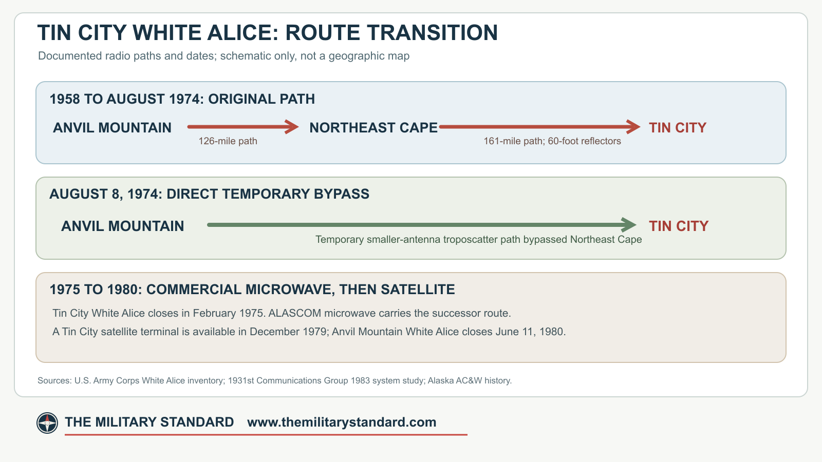
The bypass kept Tin City connected after the St. Lawrence Island relay was removed from this route. It did not mean that Tin City's radar closed, that the separate Northeast Cape Air Force Station reopened, or that Anvil Mountain was a radar antenna at Tin City. It was a communications engineering solution to the continuing need to carry warning traffic from the Bering Strait outpost. [1] [4]
From White Alice to Commercial Microwave and Satellite
The official Alaska AC&W history dates Tin City White Alice deactivation to February 1975 and says communications were rerouted from Anvil Mountain through an ALASCOM-owned microwave link. The 1983 system study describes planning for a Nome-Teller-Tin City line-of-sight commercial route and a transition whose implementation extended beyond a single date. Accordingly, February 1975 marks the end of the Tin City Air Force White Alice terminal, not the end of all communications to Tin City or the immediate shutdown of every related White Alice facility elsewhere. [3] [4]
The later satellite story also took time. In 1977, one system plan said no earth station was then intended for Tin City and routed traffic through Nome and Kotzebue. Subsequent plans changed. A Tin City satellite earth terminal was completed and available in December 1979, but contract issues delayed the actual service transfer. Anvil Mountain White Alice closed on June 11, 1980 after that problem was resolved. This sequence makes sense of the broad statement in the 1994 Corps study that satellite service eventually replaced White Alice, while preserving the intervening ALASCOM microwave phase. [2] [4]
Tin City Air Force Station itself remained an operating radar post during this change. Its AN/FYQ-9 data system had been introduced in 1965, and the later Joint Surveillance System conversion and Regional Operations Control Center depended on still newer data links. [3] [4]
Later Property Use and Visible Remains
After the Air Force White Alice mission ended, the former relay area entered a different administrative history. The Navy's 1991 account dates Air Force transfer of ownership to February 1979 and says the Navy did not accept control until 1982. Navy planners had considered Arctic experiments there, but the assessment says none had been conducted at the property by 1991. Alaska DEC's shorter records give 1978 or 1983 transfer years, apparently describing different stages of that transition. None of these later property actions reactivated the original White Alice tropospheric-scatter route. [2] [5] [7] [8]
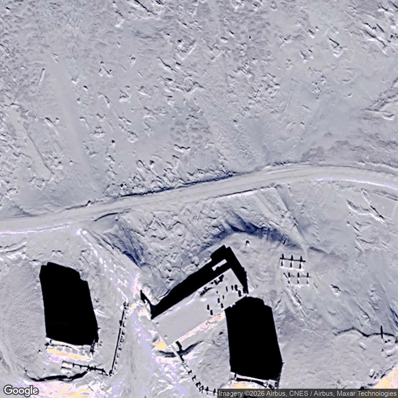
The 1989 Navy field visit found two abandoned buildings, four antenna structures, and four tanks. Navy records describe removal of most electrical equipment and draining of fuel tanks in 1984. DEC records the buildings boarded and warning signs installed in 1993. The Corps' 1994 cultural-resources plan is internally inconsistent: its White Alice entry says the facility had been demolished and lost integrity, while its Tin City radar entry describes the former relay area as intact. A dated Defense Department view from November 15, 2018 shows two upright curved reflectors and a low structure on the ridge, although the photograph does not inventory every original structure. [2] [5] [6] [8]
The relay is associated with Alaska Heritage Resources Survey number TEL-141 in the 1994 plan. Surviving structures have interpretive value because the shape and separation of fixed reflectors tell visitors and readers that they are seeing a communications path, not a radar search antenna. [2] [6]
Environmental History and Community Concerns
DEC opened a separate Tin City White Alice cleanup case covering about 6.3 acres. Its record identifies transformer-room PCB contamination, petroleum-affected areas, and asbestos-containing materials. The Navy's 1989 field investigation confirmed PCBs on the Building 1001 substation floor and described two 25,000-gallon main diesel tanks plus two 1,000-gallon antenna-area tanks, one later removed. The Navy also recorded an 850-gallon diesel release following a valve failure in 1980. [5] [8]
Investigation and public consultation continued through the 1990s. DEC, the Navy, the Air Force, Wales residents, Native corporations, and other participants discussed sampling, warning signs, exposure pathways, and cleanup. In 1999, crews removed PCB-affected soil and concrete and treated petroleum-affected soil. DEC approved a removal-action report in 2000. A final decision signed by the Navy and DEC in 2005 led DEC to record cleanup complete on November 14 of that year. The current DEC case says no institutional controls are required, although off-site transport of soil or groundwater still requires advance approval. [5]
This cleanup record matters to the nearby community and to any future property use, but the communications story remains the reason the station was built. The named radio paths, opening date, tramway, 1974 bypass, commercial microwave transition, and satellite succession define Tin City's military role. [1] [4] [5] [6]
Historical Significance
Tin City White Alice combined a demanding 161-mile over-water radio path with direct support of one of Alaska's westernmost warning radars. Its 1974 bypass records an important shift away from a St. Lawrence Island intermediate relay. Its 1975 closure and later commercial and satellite links trace the end of a distinctive Air Force communications technology without erasing the radar station's continuing mission. [1] [3] [4]
Chronology
- 1953-04 The separate Tin City AC&W radar station reaches full operation.
- 1957 Construction of the Tin City White Alice terminal proceeds.
- 1958-02-18 The Tin City White Alice terminal first transmits communications on the Northeast Cape path.
- 1963 A passenger tramway is added between the White Alice base camp and upper area.
- 1967-1968 The Corps inventory records major repairs to the composite building.
- 1969 The end of Northeast Cape radar operations prompts planning for a communications bypass.
- 1971 Planners favor a direct route using existing facilities and temporary smaller antennas.
- 1974-05-28 Work on the Anvil Mountain to Tin City bypass is authorized to proceed.
- 1974-08-08 The direct temporary tropospheric-scatter route enters service.
- 1974-08-09 The former Tin City to Northeast Cape White Alice route stops transmitting at 0124Z.
- 1974-09-18 Personnel associated with the old route depart Northeast Cape.
- 1975-02 Tin City's Air Force White Alice terminal is deactivated as commercial microwave service succeeds it.
- 1979-02 The Navy's later preliminary assessment dates the Air Force's transfer of ownership to this month.
- 1979-12 A satellite earth terminal at Tin City is completed and available, though service transfer is delayed.
- 1980-06-11 Anvil Mountain White Alice closes after the satellite transition dispute is resolved.
- 1982 The Navy accepts control of the former Tin City White Alice area, after the earlier ownership transfer.
- 1984 The Air Force removes most electrical equipment and drains former relay fuel tanks.
- 1989-07 A Navy field team inspects the inactive White Alice site from July 16 to 22 and documents its remaining buildings, antennas, and tanks.
- 1993 DEC records buildings boarded and warning signs installed at the former site.
- 1999 PCB-affected and petroleum-affected material is removed or treated.
- 2000-04-05 DEC approves the removal-action closeout report.
- 2005-11-14 DEC signs the final decision and records the White Alice case as cleanup complete.
- 2018-11-15 A Defense Department photograph documents two upright reflectors at the former relay area.
Information sources (8)
- PDF1. Historic Overview and Inventory: White Alice Communications System, U.S. Army Corps of Engineers, 1988, PDF p. 66, printed p. 59
Source for: terminal construction, 1958 opening, original and later paths, building and fuel inventory, support, tramway, and repairs
- PDF2. The Cold War in Alaska: A Management Plan for Cultural Resources, U.S. Army Corps of Engineers, 1994, PDF pp. 177-178 and 255-256
Source for: separate radar and relay histories, high-frequency predecessor, satellite succession, Navy reuse, cultural-resource statements, and TEL-141
- PDF3. History of the Aircraft Control and Warning System in Alaska, Alaska Office of History and Archaeology, PDF pp. 61-63
Source for: radar context, high-frequency limitations, February 1958 White Alice activation, February 1975 deactivation, and commercial communications
- PDF4. Special Study of the Sale of the White Alice Communications System, 1931st Communications Group, 1983, PDF pp. 51-52, 184-185, 197, 202, 233, and 238
Source for: bypass project, 1974 activation and Northeast Cape shutdown, ALASCOM microwave, satellite terminal and Anvil Mountain closure
- WEB5. Tin City White Alice Site, Hazard ID 857, Alaska Department of Environmental Conservation
Source for: NAD83 cleanup-case coordinate, approximate location, 6.3-acre case, later ownership statements, community involvement, cleanup, and 2005 disposition
- WEB6. Tin City Long Range Radar Site, DVIDS image 4914767, Senior Chief Petty Officer Brandon Raile, 2018-11-15
Source for: public-domain dated photograph of two surviving curved relay reflectors
- WEB7. Tin City LRRS, Hazard ID 24272, Alaska Department of Environmental Conservation
Source for: alternate statement of 1983 Navy transfer of former White Alice property
- WEB8. Preliminary Assessment Report: Naval Ocean Systems Center Special Areas, Alaska, Naval Energy and Environmental Support Activity, July 1991, PDF pp. 16-18, 22, 39, and 46-48
Source for: separate 6.3-acre Navy property, 1989 buildings and antenna inventory, 1952-1954 retrospective chronology, staffing, February 1979 ownership transfer, 1982 Navy control, unused Arctic-experiment plan, 1984 equipment removal, and former fuel and PCB conditions