
Tatalina Air Force Station / Tatalina Long Range Radar Site, Alaska
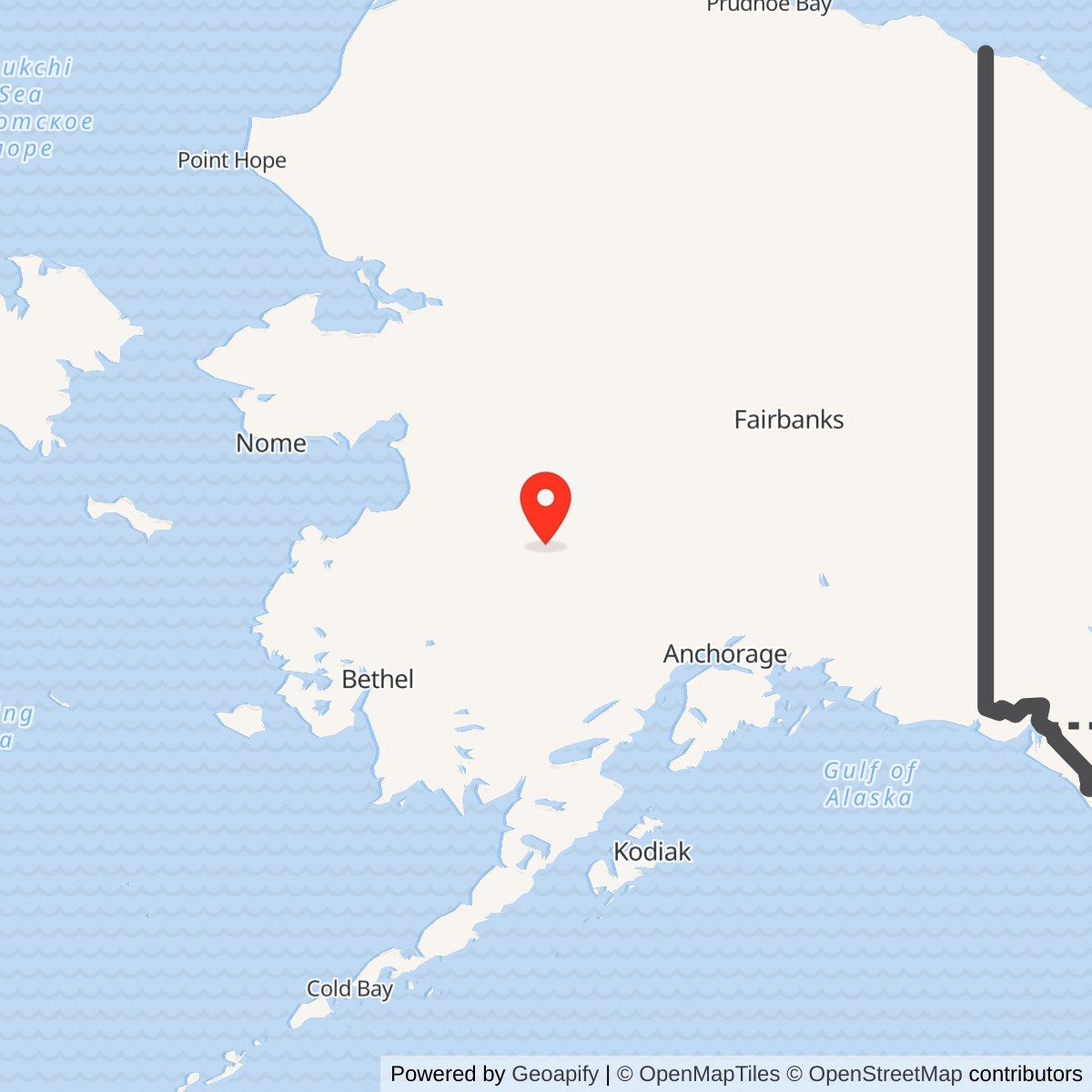
Longitude: -156.014
Current Role: Active contractor-maintained AN/FPS-117 long-range radar site supporting the Alaska Radar System, Alaska NORAD Region and FAA air-traffic surveillance. Environmental restoration, institutional controls, long-term monitoring and PFAS investigation continue.
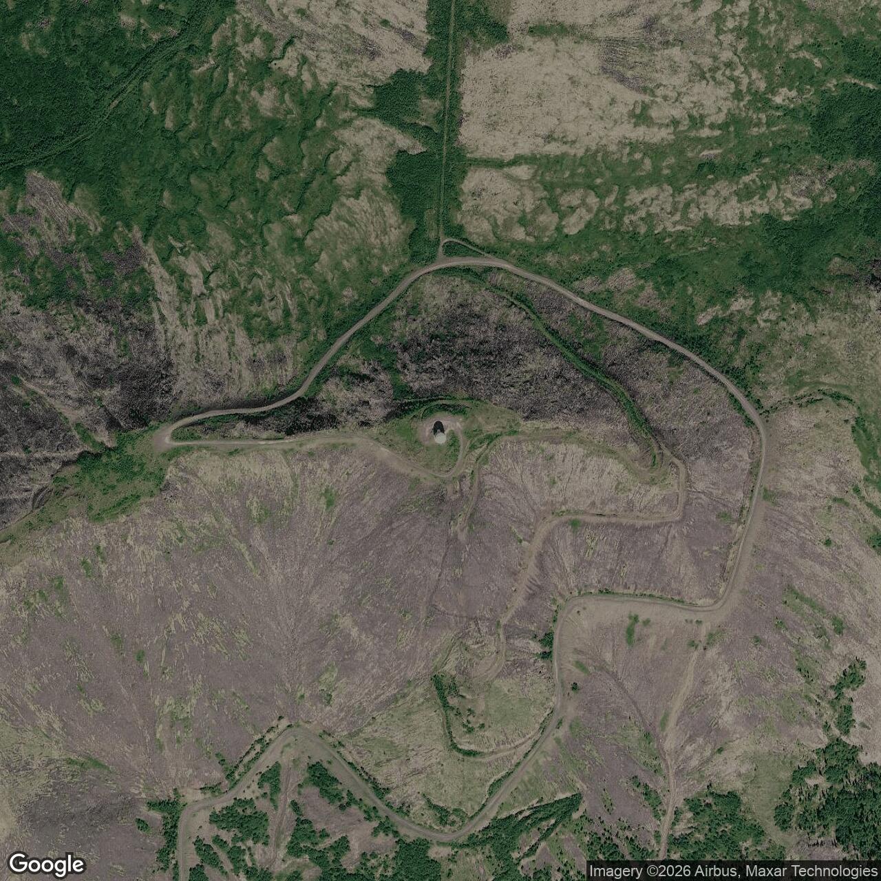
Approximate station reference point: 62.92900 N, 156.01400 W. This is not the exact radar antenna position, airstrip reference point, Sterling Landing, or surveyed property centroid.
- Role
- Active Alaska Radar System long-range surveillance site; formerly staffed aircraft-control-and-warning and White Alice communications station.
- Site identifiers
- F-10; later A-05.
- Principal unit
- 717th Aircraft Control and Warning Squadron, 1952-1983.
- Radar today
- AN/FPS-117 three-dimensional radar, operating from 1985.
- Property
- 4,968 acres across Upper Camp, Lower Camp, the airstrip, and Sterling Landing.
Tatalina Air Force Station is an active United States Air Force long-range radar installation in interior Alaska, about fourteen miles west of McGrath, near Takotna. Built during the first major expansion of Alaska's permanent postwar aircraft-warning network, it began operating in 1952 as site F-10. The 717th Aircraft Control and Warning Squadron staffed the station until 1983. Tatalina then became Long Range Radar Site A-05, with an AN/FPS-117 minimally attended radar and a small civilian contractor workforce. [1] [3]
The installation occupies 4,968 acres and includes four geographically separated operating areas. Upper Camp stands on Takotna Mountain and contains the radar. Lower Camp supported operations, housing, utilities, and logistics. An airstrip provides the principal year-round transportation link. Sterling Landing on the Kuskokwim River served summer barge supply and fuel delivery. Roads, pipelines, communications circuits, and formerly a tramway connected these parts into one operational installation. [1] [3]
Tatalina's history spans three technical eras. Operators initially reported tracks manually from an AN/FPS-93A and AN/FYQ-9 introduced semiautomatic track processing in 1965. The Seek Igloo modernization replaced the staffed radar plant with the three-dimensional AN/FPS-117 and satellite data links to the Regional Operations Control Center at Elmendorf. [1] [3]
The site remains part of the Alaska Radar System and Alaska NORAD Region. Its active mission coexists with a major environmental-restoration program. Fuel handling, waste disposal, road oiling, transformer use, fire training, and decades of remote operations created contaminated areas. Cleanup, institutional controls, long-term monitoring, and PFAS investigation continued into 2026. [1] [3]
Location and Coordinate
The approximate published station reference point is 62.92900 north latitude and 156.01400 west longitude. It identifies the general Tatalina station area, not a surveyed property centroid or the exact AN/FPS-117 antenna, airstrip, or Sterling Landing. This distinction matters because the installation extends from the Kuskokwim River supply point to the summit radar site. [1] [6] [14]
Tatalina lies on the eastern flank of the Kuskokwim Mountains. Lower Camp stood near the base of Takotna Mountain on a wooded knoll between two streams. Upper Camp is near the mountain summit at approximately 3,200 feet. The vertical separation gave the radar a broad horizon but created difficult transportation, construction, power, and maintenance requirements. [1] [6] [14]
Roads connected Tatalina's operating areas and the installation to Takotna, but not to McGrath or Alaska's highway system. McGrath is nevertheless the nearest larger community and the normal geographic reference in Air Force and state records. Aircraft and seasonal barges therefore remained essential for supplies, fuel, equipment, personnel rotation, emergency response, and environmental fieldwork. [1] [6] [14]
Strategic Origins
Alaska's proximity to the Soviet Union made it a central continental-defense problem after the Second World War. Aircraft approaching across the Arctic could reach North American targets with less warning than routes across the Atlantic or Pacific. Existing wartime facilities and temporary radars could not provide the continuous coverage required for the developing Cold War. [1] [3]
Alaskan Air Command and the United States Army Corps of Engineers surveyed the Tatalina area in 1949 and 1950. The mountain offered a useful radar horizon over the central interior and lay between other planned stations in the southern Alaska network. Its location also allowed connections toward Sparrevohn, Kalakaket Creek, McGrath, and the wider command system. [1] [3]
Construction began early in 1951. Haddock Engineers, Ltd. is identified as the principal contractor, and specialist histories give a construction cost of $4,136,353. The figure represents the early station project rather than all later improvements, radar replacements, environmental work, or communications modernization. [1] [3]
Remote construction required far more than erecting radar towers. Crews developed the airstrip, barge landing, roads, power generation, fuel storage, water and sewer systems, housing, dining, shops, communications, warehouses, and weather protection. Materials arrived by air or seasonal water transport and then moved overland to Lower Camp and up the mountain. [1] [3]
Opening and the 717th Squadron
Specialist histories place initial Tatalina operation in April 1952. The 717th Aircraft Control and Warning Squadron formally activated on December 8, 1952 and assumed responsibility for the station. Construction and correction of deficiencies continued, and the installation was not considered fully complete until 1954. These dates describe different milestones rather than conflicting opening claims. [1] [3]
The squadron initially belonged to the 531st Aircraft Control and Warning Group. It transferred to the 10th Air Division on April 13, 1953, the 5060th Aircraft Control and Warning Group on November 1, 1957, the 11th Air Division on July 1, 1959, and the 5070th Air Defense Wing on August 1, 1960. Alaskan Air Command assumed direct assignment responsibility on November 1, 1961. The 531st group structure returned in 1977 during the transition toward centralized control and contracted support. [1] [3]
Tatalina functioned as a surveillance and ground-controlled-interception station. Operators searched for aircraft, established range and bearing, requested or measured altitude, compared tracks with known traffic, and reported unidentified targets. Controllers could guide interceptors toward aircraft requiring investigation. The station contributed one sector of an overlapping network rather than defending interior Alaska alone. [1] [3]
Early Radar Equipment
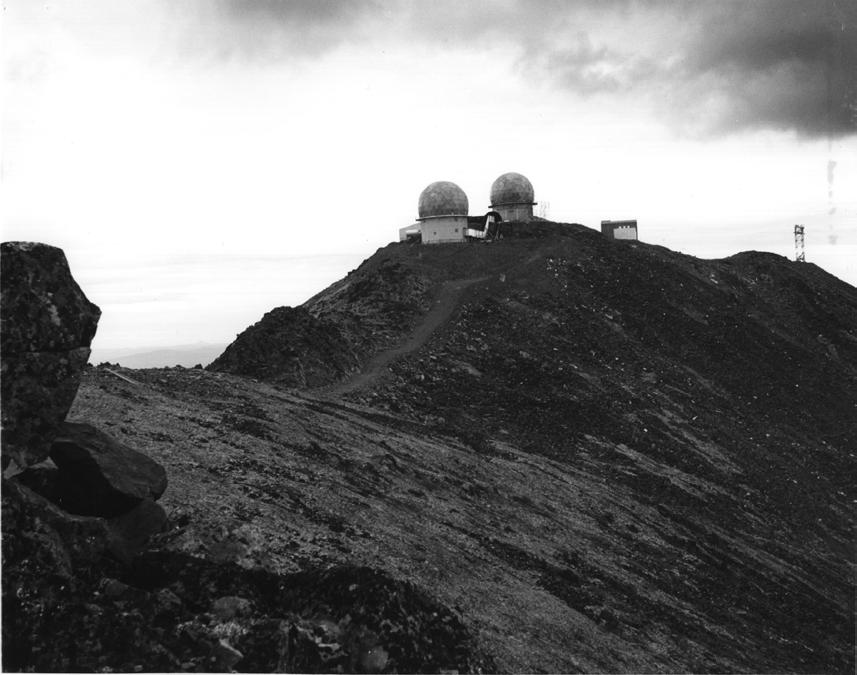
The official Alaska aircraft-control-and-warning history identifies an AN/FPS-3 as Tatalina's original search radar and an AN/FPS-6 as its height finder. The search set supplied range and bearing; the height finder directed a narrower beam toward selected tracks to obtain altitude. Search and height information together allowed a usable three-dimensional interception solution. [1] [3]
The radar plant occupied Upper Camp. The summit position improved line-of-sight coverage but exposed equipment and personnel to high winds, blowing snow, ice, cold, and isolation. Radome coverings protected antennas from weather and were heated so their material would not become brittle in extreme cold. Backup generators and emergency supplies allowed the upper site to continue during transportation or utility interruptions. [1] [3]
Approximately fifteen personnel could be quartered at Upper Camp, including radar and radio technicians and support staff. The summit area operated as a small station within the larger installation. If snow blocked the road, its personnel needed food, heat, power, communications, and repair capability until access returned. [1] [3]
Radar operators originally passed track information by voice to a manual direction center, commonly identified as Murphy Dome near Fairbanks. Manual reporting demanded disciplined plotting and communications. Operators had to describe position, course, speed, altitude, and identification while avoiding duplicated or dropped tracks. Atmospheric effects on radio and radar complicated the task. [1] [3]
Site Layout and the Tramway
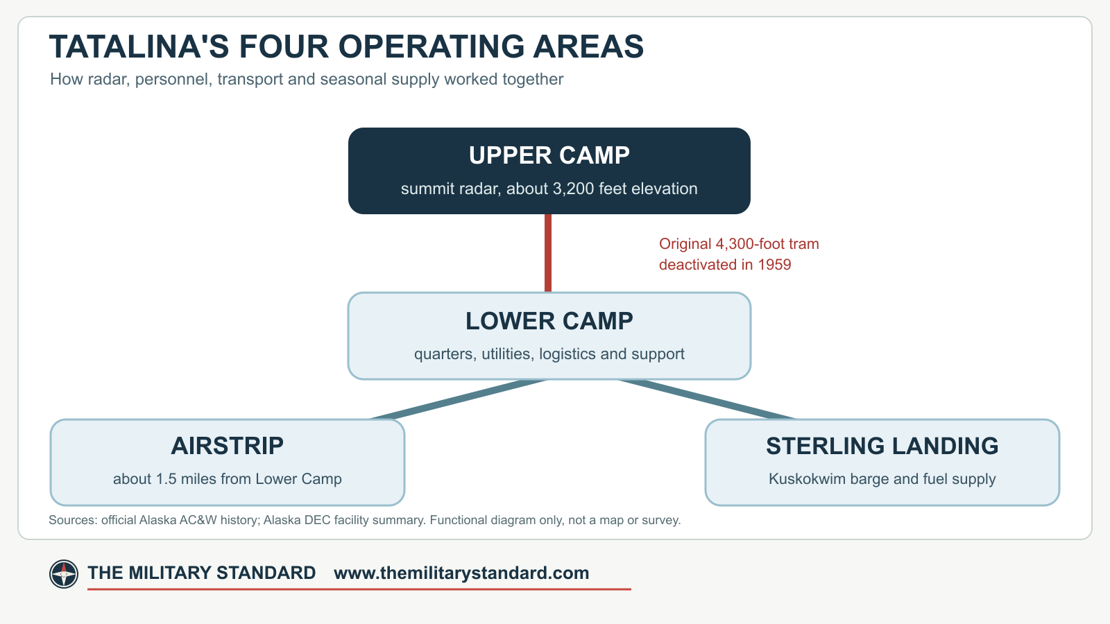
Tatalina's original physical plan separated the summit technical plant from the lower cantonment. Lower Camp included the operations and administrative area, enlisted and officer quarters, dining, recreation, civil engineering, utilities, medical support, supply, and vehicle functions. Heated passageways connected many occupied buildings and reduced the amount of time personnel had to spend outdoors. [1] [3]
A 4,300-foot aerial tramway initially moved personnel and supplies between Lower and Upper Camps. The steep mountain and severe weather made the tram attractive, but accidents and reliability problems undermined it. The Air Force deactivated the tramway in 1959. A difficult switchback road provided another route, and a longer, less abrupt road later improved access. [1] [3]
The road system was part of the mission. Snow removal, drainage, grading, bridge and culvert maintenance, slope stability, fuel delivery, and vehicle readiness determined whether technicians could reach the radar. Mountain travel could remain hazardous even when the lower airstrip was open. Emergency supplies at Upper Camp were therefore a necessary readiness measure. [1] [3]
The installation airstrip stands about one and one-half miles southwest of Lower Camp. It allowed movement of personnel, mail, food, parts, and urgent cargo. Sterling Landing, approximately sixteen miles southeast on the Kuskokwim River, received bulk fuel and heavy cargo during the navigable season. Tank farms, pipelines or transfer systems, trucks, and road corridors connected the landing with the station. [1] [3]
White Alice Communications System
High-frequency radio initially carried long-distance command traffic, but ionospheric disturbance and Arctic conditions made it unreliable. The Air Force developed the White Alice Communications System to provide dependable tropospheric-scatter and microwave links among radar stations, control centers, and communities. [1] [2] [3] [5]
Tatalina's White Alice facility was constructed in 1956 and 1957 and activated on October 27, 1957. It occupied an adjacent ridge near Upper Camp and shared installation support. The communications building covered approximately 4,160 square feet, and three petroleum tanks held a reported total of 1,325 barrels. [1] [2] [3] [5]
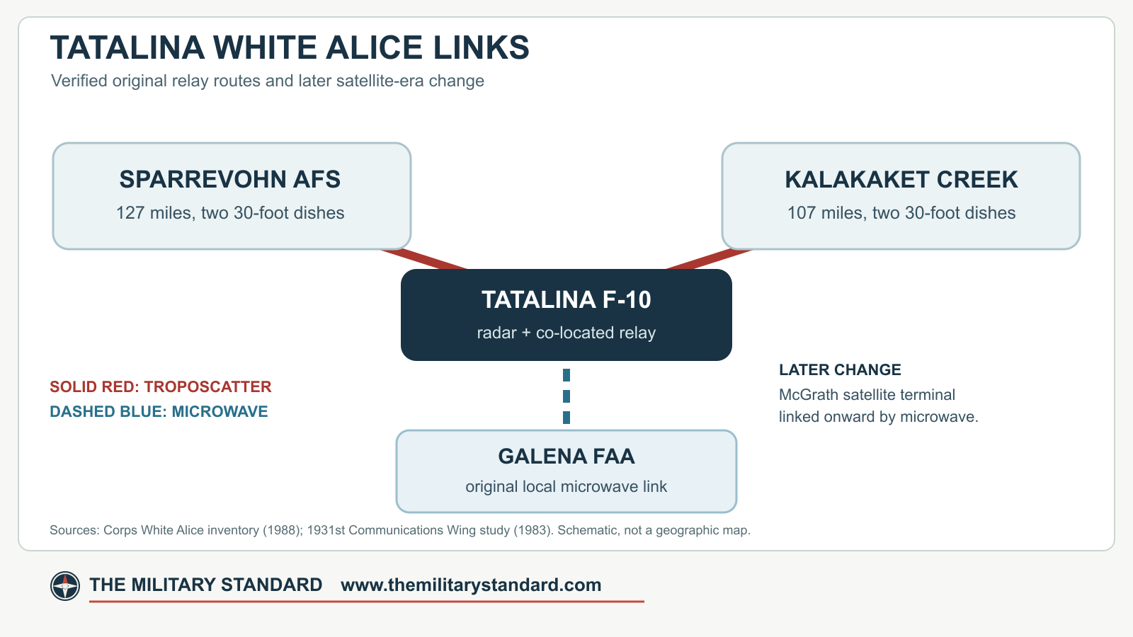
Two thirty-foot dish antennas formed a tropospheric-scatter link to Sparrevohn, approximately 127 miles away. A second two-dish path reached Kalakaket Creek, approximately 107 miles away. The Corps inventory records a local microwave connection to Galena FAA. McGrath appears later in the satellite-transition record as the location of a replacement earth terminal connected by microwave to Tatalina. White Alice provided the reliable communications backbone that manual warning and later automated control required. [1] [2] [3] [5]
The White Alice plant operated beside the radar station and drew on its support system. Its long routes linked two separate stations, Sparrevohn and Kalakaket Creek, while the local microwave route connected the air-warning system to the wider communications network. The paired thirty-foot antennas, radio building, and fuel storage gave Tatalina a substantial communications mission alongside its radar mission. [1] [2] [3] [5]
The Air Force inactivated Tatalina's White Alice operation in February 1979 as commercial satellite communications replaced the aging network. Alascom supplied the successor satellite service. Antennas and buildings were later removed during demolition and environmental work, although foundations and altered features may retain archaeological value. [1] [2] [3] [5]
Radar Modernization and Automation
A contemporary NORAD/CONAD history lists Tatalina among six Alaska stations whose AN/FPS-3-to-AN/FPS-20 conversions were operating by December 31, 1958. The later AN/FPS-93A configuration improved search capability and maintainability while retaining the surveillance mission. The AN/FPS-90 replaced or supplemented the earlier height-finding capability. [1] [4]
Tatalina did not join the continental SAGE network in the same manner as stations in the lower forty-eight states. Alaska developed its own semiautomatic control architecture. The AN/FYQ-9 Semiautomatic Data Processing and Display System became operational at Tatalina in 1965 and reduced dependence on manual voice track reporting. [1] [4]
FYQ-9 equipment encoded, processed, and displayed radar information so tracks could move through the Alaska command network more efficiently. Local operators and technicians remained essential. They verified returns, managed identification, maintained radar and data equipment, watched communications quality, and resolved discrepancies between automated and raw information. [1] [4]
The upgrade reflected a broader transition from isolated manual sites to an integrated regional system. Radar reliability alone was no longer sufficient. Data equipment, timing, communications, remote status reporting, and control-center computers became equally important parts of the surveillance mission. [1] [4]
Life at a Remote Station
Tatalina was a hardship assignment. Military tours were normally limited to one year because of isolation, climate, and psychological strain. Winter darkness, severe cold, high winds, transportation uncertainty, and separation from families affected daily life. The station's enclosed layout allowed personnel to wear light indoor clothing through much of the winter, but outside work demanded specialized Arctic equipment. [1] [3]
The 717th operated continuously. Radar and communications watches rotated around the clock. Maintenance personnel serviced transmitters, receivers, antenna drives, generators, heating plants, vehicles, data equipment, and telephone circuits. Civil engineering crews maintained roads, water, sewage, fuel systems, buildings, and snow control. Cooks, medical personnel, administrators, supply specialists, and security staff sustained the operational teams. [1] [3]
Recreation reduced isolation. Station accounts describe movies, a library, gymnasium, basketball, skating, skiing, and other activities. Mail and passenger flights were important events. Weather could delay both, making inventory control and emergency planning more consequential than at a road-connected base. [1] [3]
The upper and lower camps produced different experiences. Personnel at Lower Camp had the larger dining, recreation, and support complex. The small Upper Camp crew lived beside the radar and could be cut off from the rest of the station. Both groups depended on reliable heat, power, communications, and mutual assistance. [1] [3]
Contractor Transition
Alaskan Air Command began replacing selected military support positions with contractors in 1977. The change reduced uniformed manpower but did not end the surveillance mission. Military operators and command relationships remained during a phased transition while contractors assumed maintenance and support functions. [1] [5]
The replacement of White Alice by commercial satellite service in 1979 further reduced the need for a large communications workforce. The Air Force communications history describes an earth terminal at McGrath near Tatalina, linked onward by microwave; this was a successor arrangement, not the original White Alice microwave endpoint. Improved electronics and centralized control made it possible to operate remote sites with fewer people. These changes prepared Tatalina for the Regional Operations Control Center and minimally attended radar era. [1] [5]
The 717th Aircraft Control and Warning Squadron remained the station's principal unit until November 1, 1983. Its thirty-one years at Tatalina covered the site's manual, semiautomatic, and early centralized-control periods. The unit's inactivation ended permanent military staffing but not Air Force ownership or radar service. [1] [5]
Regional Operations Control Center and Seek Igloo
The Alaska Regional Operations Control Center at Elmendorf became operational in 1983. Tatalina began transmitting radar data by satellite to the center, which combined information from multiple military and Federal Aviation Administration sensors. The station was redesignated Tatalina Long Range Radar Site, identifier A-05. [1] [3]
Seek Igloo replaced older search and height-finding sets with the AN/FPS-117 minimally attended radar. Unlike the earlier combination of separate search and height finders, the FPS-117 is a solid-state, phased-array three-dimensional radar that provides range, bearing, and altitude. Electronic beam control and modular components reduced the need for continuous local operator staffing. [1] [3]
Installation occurred during April and May 1985, and specialist site records give May 24, 1985 as the operational date. Data traveled through satellite communications to Elmendorf's AN/FYQ-93 control-center computers. Contractors remained on site for maintenance, power, logistics, weather, and emergency work, while surveillance operators worked centrally. [1] [3]
Most original AC&W facilities, approximately thirty-four buildings and structures, were demolished during the mid-1980s. New minimally attended radar facilities included paired aluminum geodesic domes for radar operations and contractor housing, a maintenance or industrial building, an incinerator, fuel systems, and the radar tower. [1] [3]
Active Alaska Radar System Mission
After Alaskan Air Command ended in 1990, Pacific Air Forces and Eleventh Air Force assumed the radar network. The Pacific Air Forces Regional Support Center, formerly the 611th Air Support Group, manages remote radar installations and their infrastructure. The Alaska NORAD Region uses their information for aerospace warning and control. [1] [6] [8] [9] [12] [13]
Tatalina radar data also supports the Federal Aviation Administration's Anchorage Air Route Traffic Control Center. This dual military and civil contribution is characteristic of the Alaska Radar System. The site helps detect and track aircraft across sparsely populated airspace where few ground sensors are available. [1] [6] [8] [9] [12] [13]
The FPS-117 received Essential Parts Replacement Program modernization during an Air Force upgrade campaign that included Alaska and ran from 2011 to 2015. The work replaced maintenance and control equipment, beacon components, uninterruptible-power and communications racks, and local control terminals. It reduced obsolete line-replaceable units and improved remote monitoring and troubleshooting. [1] [6] [8] [9] [12] [13]
Air Force construction records document later repairs to the composite-facility fuel system, airfield lighting, and lightning protection and grounding for radar tower Building 3095. These projects confirm continued federal investment and active status. Official Air Force reporting in 2015 and 2016 continued to identify Tatalina as an active Alaska NORAD Region radar site. [1] [6] [8] [9] [12] [13]
Land and Facility Survival
Air Force environmental records identify 4,968 acres. This total covers the distributed installation, not only the radar summit or Lower Camp. The installation includes federal property and interests needed for camps, the airfield, roads, utilities, and Sterling Landing. Precise fee ownership, withdrawals, easements, and Bureau of Land Management relationships require parcel-level review. [1] [6] [7] [14]
A cultural-resource survey found that most original AC&W construction had been removed and recommended the former complex as not eligible for the National Register of Historic Places. Six AC&W-era facilities were identified as surviving: the gymnasium, water-supply building, surface weather observation facility, radar tower, airfield, and road system. [1] [6] [7] [14]
The minimally attended radar complex added four principal facilities: maintenance or industrial space, contractor residential space, an incinerator, and a fuel pump station. The paired geodesic composite buildings combined operational and living functions. Their compact arrangement reduced heating, maintenance, and staffing demands. [1] [6] [7] [14]
Surviving-feature counts should be treated as dated survey findings. Demolition, repair, environmental remediation, and modernization can change the inventory. The active radar, airstrip, fuel system, and road network remain mission property, and public access must not be assumed. [1] [6] [7] [14]
Environmental History
Decades of remote operations required large quantities of diesel fuel, aviation fuel, lubricants, solvents, batteries, transformers, paints, fire-training materials, and other supplies. Waste was historically placed in landfills or accumulation areas, and roads were oiled for dust control. Fuel moved through Sterling Landing, tank farms, pipelines, trucks, and local storage, creating multiple opportunities for releases. [1] [6] [7] [14]
An Installation Restoration Program records search in 1985 identified twenty-four initial points of interest. Seven were dismissed from further action, while the remaining areas were combined into twelve restoration sites. Later investigations addressed landfills, waste areas, spills, petroleum storage, road oiling, PCB contamination, drums, and small-arms use. [1] [6] [7] [14]
The former Lower Camp tank farm, Sterling Landing spill areas, Upper and Lower Camp landfills, and other sites required excavation, landfarming, soil treatment, monitoring, or institutional controls. Residual contamination at several locations prevents unlimited use and unrestricted exposure. Base plans and real-property records restrict excavation, movement of contaminated soil, groundwater use, and other intrusive activities. [1] [6] [7] [14]
Alaska Department of Environmental Conservation records show long-term monitoring and remedial-action operation through the 2020s. DEC approved the 2023 five-year review and annual reports covering fieldwork in 2021, 2022, 2023, and 2024. In February 2026 the agency reviewed the draft 2025 monitoring report for LF004, SS002, SS003, and SS008. [1] [6] [7] [14]
PFAS investigation adds a newer environmental issue. A preliminary assessment and site inspection found concentrations warranting remedial investigation at the former fire-training area. DEC reviewed a draft-final Phase I PFAS remedial investigation report in July 2024. The presence of an active investigation should not be converted into a claim that remedies or final boundaries have already been selected. [1] [6] [7] [14]
Environmental controls coexist with active operations. Contractor crews, Air Force engineers, environmental teams, and regulators must coordinate excavation, fuel work, construction, and monitoring. Remote access raises costs and shortens the field season, while river erosion, ponding, severe weather, and transportation limitations complicate long-term stewardship. [1] [6] [7] [14]
Historical Significance
Tatalina is significant for its unusually complete span of Alaska air-defense history. It began as a manually reporting permanent-system station, adopted improved search and height-finding radars, entered the FYQ-9 semiautomatic network, supported White Alice communications, and transitioned to satellite-linked FPS-117 operation. [1] [3]
Its physical organization demonstrates the logistical scale hidden behind a radar symbol on a map. Upper Camp, Lower Camp, the airstrip, Sterling Landing, roads, fuel systems, and communications sites all served one sensor. Maintaining that system required engineering, transportation, communications, weather knowledge, and year-round human effort. [1] [3]
The installation also illustrates the shift from a large military community to a small contractor-maintained technical site. Technology reduced local staffing while extending the mission. Tatalina remains active more than seven decades after its first radar watch, even though most buildings, equipment, and organizational structures from 1952 have disappeared. [1] [3]
Its continuity also gives the site unusual interpretive value. Tatalina did not simply close when its first radar technology became obsolete. Each modernization reused the strategic location while changing the equipment, communications, workforce, buildings, and relationship with regional control centers. The surviving road network, airstrip, selected early facilities, minimally attended radar compound, and environmental sites together preserve evidence of that long transition. A complete interpretation must therefore treat 1950s construction, 1960s automation, the 1980s Seek Igloo conversion, later radar modernization, and present cleanup as connected chapters of one installation history. [1] [3]
Chronology
- 1949 to 1950 - Alaskan Air Command and the Corps of Engineers survey the Tatalina area.
- Early 1951 - Construction begins.
- April 1952 - Tatalina begins initial radar operation as F-10.
- December 8, 1952 - The 717th Aircraft Control and Warning Squadron activates.
- April 13, 1953 - The 717th transfers to the 10th Air Division.
- 1954 - The initial station construction program reaches completion.
- 1956 to 1957 - The Tatalina White Alice communications facility is constructed.
- October 27, 1957 - White Alice service activates on the Sparrevohn and Kalakaket Creek routes.
- November 1, 1957 - The 717th transfers to the 5060th Aircraft Control and Warning Group.
- By December 31, 1958 - NORAD reports Tatalina's AN/FPS-20 conversion operating.
- 1959 - The unreliable 4,300-foot tramway is deactivated.
- July 1, 1959 - The squadron transfers to the 11th Air Division.
- August 1, 1960 - The 717th transfers to the 5070th Air Defense Wing.
- November 1, 1961 - Alaskan Air Command assumes direct assignment responsibility.
- 1965 - The AN/FYQ-9 semiautomatic data system becomes operational.
- 1976 to 1977 - Engineers examine radar harmonic interference risks for proposed satellite communications.
- 1977 - Contractors begin replacing selected military support personnel.
- February 1979 - Tatalina White Alice service ends as satellite and microwave connections succeed its original routes.
- July 1979 - White Alice property is inventoried for disposal.
- 1983 - Tatalina begins sending radar information by satellite to the Elmendorf ROCC.
- November 1, 1983 - The 717th inactivates and Tatalina becomes Long Range Radar Site A-05.
- Mid-1980s - Approximately thirty-four original AC&W facilities are demolished.
- April to May 1985 - The AN/FPS-117 minimally attended radar is installed.
- May 24, 1985 - The FPS-117 becomes operational.
- 1990 - Pacific Air Forces and Eleventh Air Force assume the former Alaskan Air Command radar mission.
- 2011 to 2015 - Essential Parts Replacement Program modernization updates Alaska FPS-117 systems, including Tatalina.
- 2013 - Records of decision establish remedies and institutional controls for major restoration sites.
- 2016 - Air Force reporting documents four contractors assigned to maintain the active site.
- 2021 - Remedial construction removes buried drums and petroleum-impacted soil at SS011.
- 2023 - DEC approves a five-year review and records cleanup completion for SS011.
- July 2024 - DEC reviews the Phase I PFAS remedial investigation for the former fire-training area.
- April 2025 - DEC approves the final 2024 remedial-action operation and monitoring report.
- February 2026 - DEC approves the 2025 long-term management report for monitored cleanup areas.
Information sources (14)
- PDF1. History of the Aircraft Control and Warning System in Alaska: Air Defense of Arctic Skies
Source for: Construction, 717th squadron, physical layout, radars, AN/FYQ-9, Seek Igloo and historical photograph.
- PDF2. A Historical Overview of the White Alice Communications System
Source for: Original Tatalina routes, 30-foot antennas, Galena FAA microwave link, facility size and fuel storage.
- PDF3. The Cold War in Alaska: A Management Plan for Cultural Resources
Source for: Station facilities, shared White Alice support, 1957 activation and 1979 closure.
- PDF4. NORAD/CONAD Historical Summary, July-December 1958
Source for: Contemporary confirmation of Tatalina AN/FPS-20 operation by December 31, 1958.
- PDF5. 1931st Communications Wing, White Alice Communications System Sale and Transfer Study, 1983
Source for: Satellite transition, McGrath earth terminal, FPS-93 interference planning, 1979 shutdown and communications workforce.
- WEB6. Tatalina Long Range Radar Station Facility Summary
Source for: Current 4,968-acre site, four-area layout, active mission, environmental status and PFAS program.
- WEB7. Tatalina LRRS SS003 POL Tank Farm Site Report
Source for: Institutional controls, annual reporting and 2026 monitoring record.
- WEB8. Proficiency Is Key When Accessing Alaska's Remote Locations
Source for: Air Force account of current radar-site access and active Alaska NORAD Region work.
- WEB9. Securing Airspace: JBER Supports PRSC Tenant Unit
Source for: Present regional support and contractor-maintained Alaska Radar System context.
- WEB10. Tatalina Air Force Station Site Record
Source for: Secondary cross-check for F-10/A-05 codes, 717th squadron and radar chronology.
- WEB11. Tatalina Air Force Station
Source for: Secondary cross-check for unit dates and the May 24, 1985 FPS-117 service date.
- WEB12. Radar Upgrades Ensure Situation Awareness
Source for: Air Force description of the AN/FPS-117 Essential Parts Replacement Program and its Alaska deployment.
- WEB13. FY17 Air Force Facility Sustainment, Restoration and Modernization Projects
Source for: Tatalina composite-facility fuel-system repair listed by the Air Force Civil Engineer Center.
- PDF14. Final Report for Environmental Long-Term Monitoring at Tatalina LRRS Sites, February 2016
Source for: Local road to Takotna, four assigned contractors, four-area property layout, and active radar status in 2016.