
Kalakaket Creek Radio Relay Station, Alaska
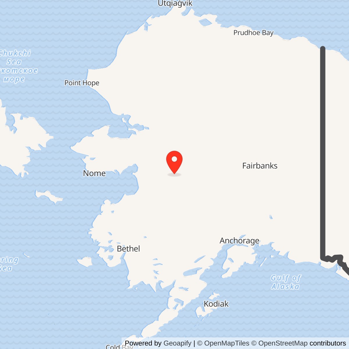
Longitude: -156.835914
Current Role: Former, overgrown relay and support landscape with capped landfills, warning signs, monitoring wells and regulated land-use areas. No operating radio mission or airstrip use documented. Parcel title and public access require current land-record verification.
Location: About 20 miles south of Galena, Alaska. The 2009 Air Force decision gives a NAD83 station-location point of approximately 64.427261 N, 156.835914 W. It is not a surveyed installation centroid or property boundary. Alaska DEC has a separate NAD27 environmental-case marker.
- Role
- Staffed White Alice troposcatter and microwave communications junction, not an aircraft-search radar.
- Opened
- May 25, 1957, according to two Corps histories.
- Radio service ended
- 1973, according to the Air Force Record of Decision; later facility and cleanup activity continued.
- Original links
- North River, Bear Creek and Tatalina, with later Campion and Galena microwave connections.
- Present condition
- Standing station facilities demolished in 2009. Environmental controls, landfills and groundwater monitoring continue.
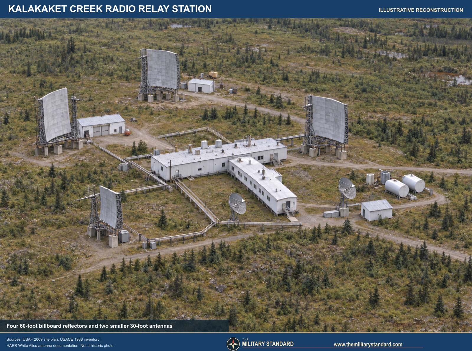
Kalakaket Creek Radio Relay Station was a staffed U.S. Air Force White Alice communications junction about 20 miles south of Galena, Alaska. Opened on May 25, 1957, it joined three long-distance tropospheric-scatter paths with later microwave connections serving the aircraft-control-and-warning network. Its enormous antennas did not search for aircraft. They carried information between defense facilities over distances and terrain where conventional line-of-sight communication was impractical. The Air Force's 2009 Record of Decision says the relay operated continuously until 1973, when satellite communications replaced it. Physical occupation and cleanup continued afterward, a distinction that explains why some environmental summaries use a broader 1956 to 1978 facility interval. The buildings and antennas were demolished in 2009, but the landfills, petroleum-affected groundwater, institutional controls and federal stewardship make the site an active environmental case in 2026. [1] [2] [3] [6] [7]
Origins and construction
Alaska's radar stations could detect aircraft only if their observations reached command centers and fighter-control facilities reliably. The mid-1950s White Alice Communications System used high-capacity tropospheric scatter for long, over-the-horizon paths and microwave radio where line of sight was possible. In troposcatter operation, directional antennas transmitted toward the lower atmosphere; a remote station recovered a small fraction of the energy scattered forward. The technique demanded powerful transmitters, large antennas, generating capacity, shelter and constant maintenance. Kalakaket was therefore a substantial installation rather than a bare antenna site. [1]
The Corps of Engineers' historical inventory places construction in 1956 and 1957 and records the May 25, 1957 opening. The Corps' 1994 cultural-resources plan independently repeats the exact opening date. The 2009 Air Force decision describes it as originally constructed in the 1950s and operating continuously until 1973. The three accounts are compatible on the start of service, but none is an original acceptance certificate or construction contract. The existence of Air Force test pits from 1956, noted in the environmental decision, supports active site preparation that year. The original White Alice program depended on Corps site selection and construction work and Western Electric electronics installation. [1] [2] [3]
Location, land and layout
The station occupied a low, flat-topped mountain at the northern edge of the Yukon-Kuskokwim uplands. The upper radio compound stood near 1,950 feet above sea level, while an airstrip on a lower shoulder, about a mile southwest by road, lay near 1,600 feet. A 2007 federal public-health assessment gives a 4,090-foot gravel airstrip; the 2009 Record of Decision rounds it to 4,000 feet. Those are reported lengths from different summaries, not evidence of a documented runway extension. The road and airstrip were essential to moving personnel, diesel fuel, antenna and generator parts into a location without routine highway access. The Corps described access as by air. A water intake gallery and pump house lay to the east near an unnamed stream, and Kalakaket Creek itself is about two miles west of the old installation. [2] [3] [4]
There is an unresolved acreage difference. The 2007 public-health assessment describes approximately 316 acres, whereas the 2009 decision says the radio relay station covers 302 acres. Both are approximate historical descriptions and may reflect different land-accounting scopes. Neither document is a present-day cadastral survey. The 2009 decision places the facility in sections 22, 23, 26 and 27, Township 12 South, Range 10 East, Kateel Meridian, but later in its physiography section lists only three of those sections. [3] [4]
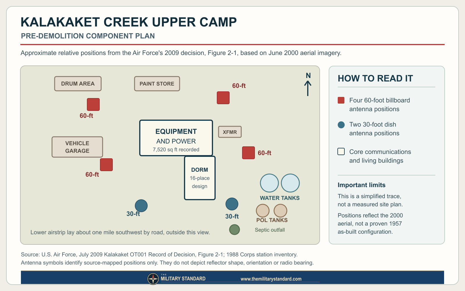
The 2009 decision provides the most detailed surviving area plan reviewed. It divides the former station into Upper Camp, Airstrip and Miscellaneous investigation areas with 16 environmental subareas. Upper Camp included the antenna feeder horns and fuel systems, equipment building, transformer shed, dormitory, fire pump house, paint storage, fuel tanks, septic outfall and vehicle garage. The airstrip area included a warehouse, fuel tank and two drum-storage areas. The water pump house and remote drum cache were separate outlying subareas. These are environmental-investigation labels derived from former functions, not a count of independently registered military installations. The decision's figures are based on aerial imagery flown on June 14, 2000, before the major 2009 demolition. The later Air Force map shows the approximate installation boundary and modern controlled areas, but says its station boundary was georeferenced and screen-digitized from a 2020 plan. It is not a surveyed original property boundary. [3] [6]
The Corps' inventory records a 7,520-square-foot equipment and power building and a 5,200-square-foot dormitory designed for 16 people. It also gives three petroleum, oil and lubricant tanks with total capacity of 7,000 barrels. The 2009 decision describes radio electronics and power generation together in the equipment building, and three transformers in a small shed on a six-by-eight-foot pad along its south side. Its plan labels two large water-storage tanks, a fire pump house and fuel tanks near the summit. The building areas and dormitory design capacity describe historical construction, not buildings still standing. The 16-person figure is not proof that exactly 16 personnel were present on every day or shift. [1] [3]
Communications equipment and direct routes
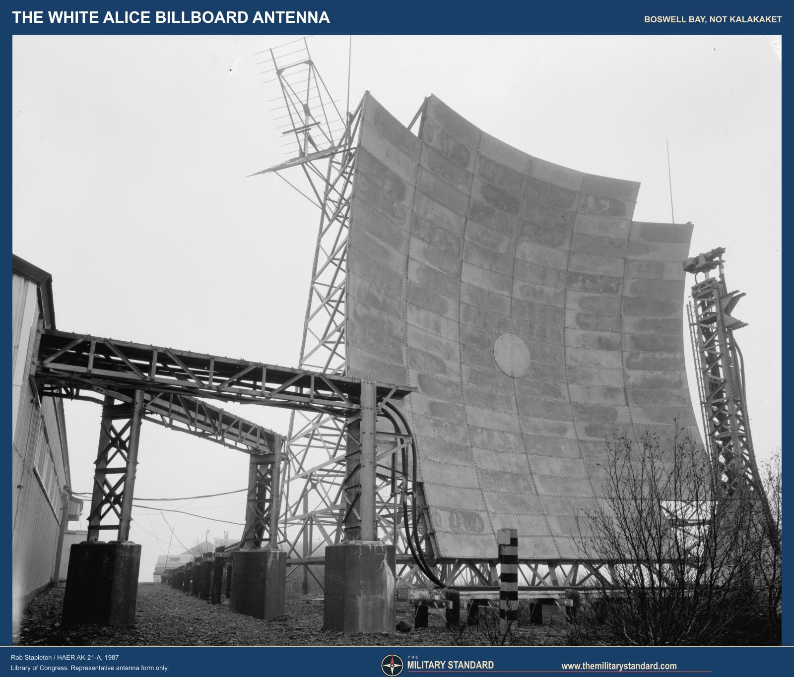
Kalakaket's three original long paths are unusually well documented. The North River route was 118 miles and the Bear Creek route 155 miles, each with a pair of 60-foot billboard antennas. The Tatalina route was 107 miles with a pair of 30-foot dish antennas. The Air Force's 2009 decision confirms the same three neighbors and antenna categories. Its station plan shows two labeled 30-foot antenna positions and multiple 60-foot antenna positions, feeder horns and associated fuel-system subareas. The term "60-foot" describes the historical antenna size used in the station inventories; it must not be reinterpreted as a precisely surveyed tower height or an exact model designation. [1] [2] [3]
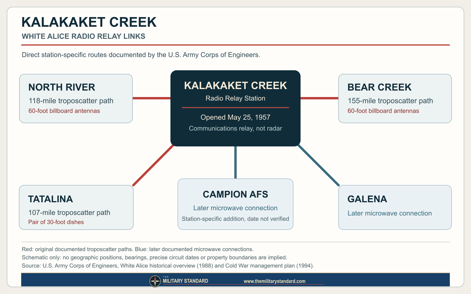
The site later gained microwave links to Campion Air Force Station and Galena Air Force Station. The Corps' 1994 plan gives both connections without dates. The 2009 decision says Campion was connected and Galena came later, but again supplies no commissioning date for either. Campion and Galena were radar and air-defense facilities connected by communications, not component areas of Kalakaket. [1] [2] [3]
Kalakaket also appears in the Corps' discussion of Project Stretchout, which added automatic switching and redundancy to the White Alice network. Big Mountain, Neklasson Lake, Pedro Dome and Kalakaket Creek formed a redundant switching rectangle in that program description. This is a network-level relationship, not proof that Kalakaket had a direct antenna aimed at each of the other three sites. The source record does not establish a station-specific transmitter model roster, operating frequency, circuit count, signal capacity or dated hardware replacement sequence. [1]
Life and logistics at a remote junction
The combination of a 16-person dormitory, large power plant, extensive fuel storage, airstrip, water supply and maintenance garage shows that Kalakaket required continuing human support. The upper camp was separated from the lower airstrip by a gravel road, so moving fuel and supplies to the antennas was a further task after aircraft delivery. Later environmental records identify a warehouse at the strip, historically also called the temporary garage, where supplies may have been held before transfer uphill. They also identify a small fire-trailer shelter near it, apparently associated with airfield emergency equipment. These details make the installation's operating geography more intelligible, even though original logistics orders and maintenance logs have not been found. [1] [3] [4]
The airstrip should not be treated as a separate Air Force base. It was a support component of the relay. Its later overgrowth made routine aircraft access impractical, and the Air Force's restoration teams depended on helicopters and difficult seasonal ground or river transport. A 2009 Air Force account describes a contractor building an ice bridge and moving a tracked supply train along the Yukon River to support demolition. That is evidence about the 2009 cleanup operation, not how every 1950s resupply mission was performed. The May 2026 report records 2025 inspections interrupted by low cloud and poor weather, a reminder that access continues to govern even environmental work. [3] [6] [8]
The evidence does not identify a continuous on-site Air Force unit roster, a sequence of civilian operating contractors, a shift pattern or the names of Kalakaket's operators. It would be misleading to call the 5099th Civil Engineering Operations Squadron an operating radio unit: the 2009 decision identifies that squadron in connection with a 1984 cleanup. The dormitory's 16-person design is the strongest local staffing figure, and no source reviewed proves that it was always filled. [1] [3]
Deactivation, occupation and property
The 1994 Corps plan and the 2009 Air Force decision put communications deactivation in 1973. The latter says the station had operated continuously until satellite replacement. Some Alaska DEC summaries say the facility operated from 1956 to 1978 and the 2009 decision says it had been unoccupied since the late 1970s. These statements probably use different endpoints: active radio service, physical occupation, contractor or property activity, and final abandonment. [2] [3] [7]
The original plan to dispose of White Alice communications assets in the late 1960s and 1970s did not automatically privatize this particular parcel. The 2009 decision says Public Land Order 1740, issued in 1958, had withdrawn public land including Kalakaket for military use. At that time the Air Force anticipated that the land would return to Bureau of Land Management administration when released. That was a prospective statement in a 2009 decision, not proof that a transfer was completed. The record reviewed does not contain a withdrawal revocation, deed, current title opinion or public-access grant. The Air Force's ongoing remedial responsibilities and DEC's active case should not be confused with a verified statement that it holds every surface right in 2026. [3] [6] [7]
The Corps' 1994 preservation survey called Kalakaket abandoned and in poor condition, assigned Alaska Historic Resources Survey number NUL-061, and did not recommend preservation because of remoteness and deterioration. It described the station then as under Air Force control. A line in the plan says the White Alice system was National Register listed; it is not sufficient evidence of an individual Kalakaket listing. By 2009 the Air Force's Clean Sweep removed all buildings and infrastructure, according to the 2016 review and 2026 report. Thus the former station is historically significant as a network node, but not an intact standing antenna complex. [2] [5] [6]
The first environmental actions, 1984 to 2007
Kalakaket's post-service record is not a single cleanup event. The 5099th Civil Engineering Operations Squadron worked at the property from September 28 through November 9, 1984. The Air Force's later decision says crews tested containers for liquid PCBs, shipped PCB wastes and heavily contaminated soil off site through Elmendorf, and buried designated nonhazardous debris in two permitted one-time-use landfills, LF1 and LF2. The burial inventory included cleaned empty fuel tanks, several vehicles and truck beds, and 3,250 cleaned and crushed empty 55-gallon drums. The historical description of the buried material as nonhazardous reflects the action's documentation; it does not negate later findings of petroleum contamination at LF1 or the need to maintain landfill caps. [3]
Records-only preliminary assessments followed in 1988 and 1993. A 1994 field assessment collected soil screening and laboratory samples and found petroleum hydrocarbons, PCBs and pesticides. A much larger supplemental investigation in 2007 sampled surface and subsurface soil, groundwater and surface water to define the source areas and possible exposure pathways. The Air Force's 2009 decision separated 16 OT001 subareas into the upper camp, airstrip and miscellaneous groups. Five showed CERCLA hazardous substances above Alaska levels then used for unrestricted exposure: equipment building, equipment-building transformer, septic outfall, airstrip warehouse and Drum Storage Area 2. Other petroleum-affected areas followed a separate state-law decision process. [3]
The suspected sources were related to real station functions. PCBs were associated with electrical and radio equipment and transformers. The transformer subarea contained a shed and pad south of the main equipment building. The old septic outfall extended downslope from a tank roughly 200 feet south of the building; sampling found PCBs, pesticides and petroleum near the discharge area. At the airstrip warehouse, investigators found a small PCB-affected location and 1,2,3-trichloropropane in one soil sample. At Drum Storage Area 2, historical spills were associated with 55-gallon drum storage. The 2009 decision's table gives some very high maximum PCB concentrations, but its own correction section changes one transformer maximum. The verified fact is that soil in identified source areas exceeded the applicable cleanup criteria, not that one inconsistent number should be repeated as a definitive sitewide maximum. [3]
The 2007 federal public-health assessment responded in part to concerns from the Louden Tribal Council about Galena, Campion and Kalakaket. Based on the sampling available then, the Agency for Toxic Substances and Disease Registry did not identify a harmful exposure pathway through local drinking water or traditional subsistence foods. That is a bounded public-health assessment, not a declaration that all Kalakaket soil was clean or that later petroleum groundwater monitoring was unnecessary. It predates the final 2009 remedy and 2025 field results. The 2009 Air Force decision also recognized recreational and subsistence use around the remote property, rather than assuming no potential visitors merely because there were no permanent residents at the station. [3] [4]
The 2009 decision and Clean Sweep
The July 27, 2009 OT001 Record of Decision selected excavation and offsite disposal of soil above cleanup levels for PCBs, dieldrin and 1,2,3-trichloropropane at the five CERCLA subareas. It used then-applicable soil criteria of 1.0, 0.32 and 0.17 milligrams per kilogram respectively. Petroleum contamination and the two older landfills were outside that CERCLA decision and had separate state-law controls or monitoring. The decision estimated about $3.59 million in 2009 dollars for the selected CERCLA remedy; it was an estimate for that remedy, not the total historical construction or cleanup cost of the installation. Public comment was invited in May and June 2009, including a meeting in Galena. Eleven people submitted verbal or written comments. The decision records questions about spending at a remote place and discussion of contaminants' potential bioaccumulation. [3]
Clean Sweep in 2009 abated and demolished the abandoned structures and infrastructure, excavated contaminated soil and built a new onsite municipal solid-waste landfill in the Upper Camp area. During implementation, the excavated PCB soil volume exceeded initial estimates. Although the signed decision had selected offsite disposal, Alaska DEC approved placement of soil containing more than 1 but less than 10 milligrams per kilogram PCBs in the onsite landfill. Soil above 10 went offsite. Some petroleum-affected soil was landspread until it met the applicable criteria and then reused as landfill cover; lead-affected soil at the vehicle garage was sent offsite. These are different treatment and disposal pathways and must not be compressed into "all contamination removed." [3] [5] [6]
DEC approved the final Clean Sweep report on May 12, 2010, and recorded a September 30, 2010 remedy-in-place or remediation-complete milestone with institutional controls. That status did not cancel the land-use restrictions, groundwater monitoring or landfill maintenance. The 2016 Five-Year Review identified a documentary discrepancy: the onsite low-level PCB disposal differed from the final ROD's offsite-only language. It recommended an Explanation of Significant Differences or ROD amendment to formally record the approved change. The May 2026 report still lists the same documentation action among recommendations carried from a later review. The reviewed sources do not establish that a final ESD or amendment had been executed by October 2026. [5] [6]
Landfills, monitoring and changing protectiveness findings
The 2016 first Five-Year Review judged the OT001 and LF002 remedies protective at that time, with no immediate threat, while identifying issues that could affect future protectiveness. Metal had previously protruded through the older landfill cover, and the report called for continuing inspection and repair. It also urged a formal change document for the PCB disposal, evaluation of low-yielding wells, sampling of an airstrip oil stain, and recording a property restriction. Its review of 2011 to 2014 groundwater data found earlier petroleum exceedances at the airstrip fuel-tank area, with the 2014 sample results below then-current levels. It explicitly noted that poor recharge prevented complete sampling from some wells. A one-year improvement in sampled wells did not prove permanent closure. [5]
A later five-year review, summarized in the May 2026 Air Force report, reached a more guarded position: protectiveness for LF002 could not be determined until the landfill-cap condition was assessed, and protectiveness for OT001 could not be determined until the reported oil-stained area was sampled. This is a change in the state of evidence, not a contradiction to be hidden by citing only the favorable 2016 statement. The 2026 report describes work undertaken in 2025 to evaluate those concerns, but it continues to distinguish recommendations, work under a separate contract, and regulatory decisions. Neither an Air Force recommendation nor a clean result from one well is by itself an Alaska DEC closure letter. [5] [6]
The May 2026 report covers field visits on August 22 and September 24, 2025. At LF1, crews saw buried vehicle frames and metal debris exposed along the eastern edge, evidence that the cap was eroding and not functioning as intended there. Only one of four LF1 wells yielded a sample; its analyzed contaminants were below cleanup levels or not detected. The other three wells were dry or had too little water. The report recommended repair of the cap and continuation of five-year visual controls, while recommending that LF1 groundwater sampling be discontinued. That latter recommendation has not been treated here as an approved regulatory change. [6]
At LF2, heavy vegetation prevented the monitoring team from landing and doing an on-ground inspection. A separate 2025 assessment, summarized in the report, found an estimated cap thickness from zero to 2.5 feet, standing water in the center, and about half a cubic yard of exposed debris. The report recommended cover repair, reseeding and continued inspections. The site had three new warning signs under separate work, but physical access remained difficult. It would be incorrect to infer that LF2 was sound merely because the main inspection team saw no problem from the air. [6]
At the former POL Tank 1 area beside the airstrip, two control signs were in good condition and investigators did not relocate the oil stain seen in 2014 and 2015 or the 2020 sheen. They sampled three groundwater wells; at PT1SB09 diesel-range organics, naphthalene and two methylnaphthalenes exceeded Alaska cleanup levels. Other results were below or not detected. The report recommended continued five-year inspections and groundwater monitoring. Two intended monitoring wells could not be found in the dense growth. The absence of a visible stain in 2025 therefore cannot be represented as a cleanup-complete finding for the former tank area. [6]
DEC's sitewide record remained active as of the October 2026 review. The Air Force report separately names hazard IDs 4676 for LF1, 4677 for LF2 and 4669 for OT001, while the DEC sitewide record uses hazard ID 769. These are environmental case identifiers and subareas of the Kalakaket installation, not reasons to create four military installation UIDs. A distinct remote-drum environmental record also exists. The environmental database's occasional description of a "White Alice radar" is imprecise: this installation carried radio communications for the radar network, not a radar search mission of its own. [3] [6] [7]
Present landscape, coordinates and historical significance
By the 2025 fieldwork, the former operating and airstrip areas were largely overgrown. The upper camp's standing antenna and building structures had been removed in 2009; monitoring wells, warning signs, capped wastes, roads or road traces, and subsurface remains persisted. The 2026 report recommends limiting routine OT001 inspections to the still-controlled PT1 subarea because several other subareas had already been recommended for closure after Clean Sweep. "Recommended for closure" is not interchangeable with a separate DEC closure determination for every subarea. The site is not a restored White Alice exhibit or an operating airfield. Land restrictions and uncertain access mean visitors should not treat the old airstrip or compound as an unrestricted public destination. [5] [6] [7]
Two coordinate records require careful labeling. The 2009 Record of Decision prints 64 degrees 25 minutes 38.14 seconds N, 156 degrees 50 minutes 9.29 seconds W, NAD83, as a facility-location point. Converted to decimal degrees, that is approximately 64.427261 N, 156.835914 W. Alaska DEC's sitewide entry uses 64.430806 N, 156.836056 W on NAD27 as an environmental case marker. These points are not interchangeable by simple rounding, and neither is a surveyed antenna center, original installation centroid or parcel corner. [3] [6] [7]
Kalakaket illustrates the value and cost of the White Alice network. Its three original paths linked isolated relay and aircraft-warning regions; its later Campion and Galena connections made it part of a changing local air-defense communications pattern. The physical plant brought diesel power, fuel, housing, road, water system and aircraft access to a remote mountain. Deactivation came quickly as satellite communications matured, but responsible disposal and environmental stewardship lasted decades. The strongest station-specific evidence covers opening, routes, antenna sizes, component areas, 1973 relay deactivation and the 1984-2025 cleanup sequence. Original circuit diagrams, transmitter models, operating personnel records, the precise transfer history and a surveyed parcel boundary remain open research topics. [1] [2] [3] [5] [6] [9]
Chronology
- 1956 Air Force test pits and station construction activity are documented for the upper camp; the Corps dates construction to 1956-1957. [1] [3]
- 1957-05-25 Kalakaket Creek Radio Relay Station opened as a White Alice combined troposcatter and microwave station. [1] [2]
- 1958 Public Land Order 1740 withdrew federal land including the station for military use, according to the 2009 Air Force decision. [3]
- 1973 The station's continuous radio-relay service ended with satellite-system replacement, according to the Corps and Air Force decision. [2] [3]
- Late 1970s The property was unoccupied by this period, although the exact last non-radio activity and disposition dates remain unclear. [3]
- 1984-09-28 to 1984-11-09 The 5099th Civil Engineering Operations Squadron conducted removal and disposal work and used two permitted one-time landfills. [3]
- 1988 An Air Force records-based preliminary assessment reviewed the former station. [3]
- 1993 A second records-based preliminary assessment was completed. [3]
- 1994 Field assessment and sampling detected petroleum hydrocarbons, PCBs and pesticides in station areas. [3]
- 2007 A supplemental site investigation/remedial investigation sampled soil, water and source areas across the property. [3]
- 2009-07-27 The Air Force and Alaska DEC signed the OT001 Record of Decision for CERCLA hazardous substances in five subareas. [3] [5]
- 2009-09 Clean Sweep demolished the abandoned buildings and antennas and carried out major soil removal and onsite landfill construction. [5] [6]
- 2010-05-12 Alaska DEC approved the final Clean Sweep report. [5]
- 2010-09-30 DEC recorded a remedy-in-place or remediation-complete milestone with institutional controls, not unrestricted use of the entire property. [5]
- 2011-09 Long-term monitoring at OT001 began, triggering the first statutory five-year review cycle. [5]
- 2014-07 Air Force inspections documented an oil stain near the airstrip and continued groundwater monitoring. [5]
- 2016-04 The first Five-Year Review judged the remedies protective at that time but required continuing controls and recommended documenting the onsite PCB disposal change. [5]
- 2020 A later review identified unresolved landfill-cap and oil-stain questions, as summarized in the 2026 Air Force report. [6]
- 2025-08-22 Inspectors sampled one LF1 well and documented exposed debris at its landfill-cap edge. [6]
- 2025-09-24 Inspectors returned for OT001 and LF2 work; the PT1 well PT1SB09 exceeded several groundwater cleanup levels. [6]
- 2026-05 The final Air Force long-term-management report documented the 2025 field findings and recommended continued controls and specified cap repairs. [6]
Information sources (9)
- PDF[1] U.S. Army Corps of Engineers, Historical Overview and Inventory: White Alice Communications System, April 1988, especially the Kalakaket Creek station entry and Stretchout discussion
Source for: opening and construction dates, direct route lengths, antenna sizes, support-building areas, dormitory design, POL capacity and switching-network role.
- PDF[2] U.S. Army Corps of Engineers, The Cold War in Alaska: A Management Plan for Cultural Resources, August 1994
Source for: station location and access, relay paths, 1973 deactivation, 1994 physical condition, Air Force control and AHRS number NUL-061.
- PDF[3] U.S. Air Force, Final Record of Decision, IRP Site OT001/White Alice Site, Kalakaket Creek Radio Relay Station, July 2009
Source for: station layout and location point, 302-acre figure, operational endpoint, land-withdrawal context, 1984 cleanup inventory, investigations, contamination, public process and selected CERCLA remedy.
- PDF[4] Agency for Toxic Substances and Disease Registry, Public Health Assessment: Galena Airport, Campion Air Station, and Kalakaket Creek White Alice Station, 2007
Source for: 316-acre figure, reported airstrip and elevation details, component areas and bounded public-health conclusion.
- PDF[5] Air Force Civil Engineer Center, Kalakaket Creek Radio Relay Station, Sites OT001 and LF002, 2016 Five-Year Review, April 2016
Source for: 2009-2014 remedy implementation and groundwater findings, 2016 protectiveness statement, onsite PCB-disposal discrepancy and follow-up recommendations.
- PDF[6] 611th Civil Engineer Squadron North Group, Final 2025 Kalakaket Creek RRS Long-Term Management Report, May 2026
Source for: 2025 field dates, current cleanup areas, mapped control boundaries, exposed landfill debris, sampling results, inspection limits and 2026 recommendations.
- WEB[7] Alaska Department of Environmental Conservation, Kalakaket Creek RRS Sitewide, hazard ID 769
Source for: current active environmental case, site chronology and the NAD27 environmental reference marker.
- WEB[8] Joint Base Elmendorf-Richardson, Operation Clean Sweep, March 23, 2009
Source for: contemporary Air Force account of the seasonal ice-bridge and supply-train logistics for the demolition project.
- PDF[9] Anchorage Museum, William C. and Frances P. Ray Slides, B2016.006 collection guide
Source for: identification of July 1957 Kalakaket photographs as future visual-reference leads; no reproduction rights are claimed.