
Sparrevohn Air Force Station / Sparrevohn Long Range Radar Site, Alaska
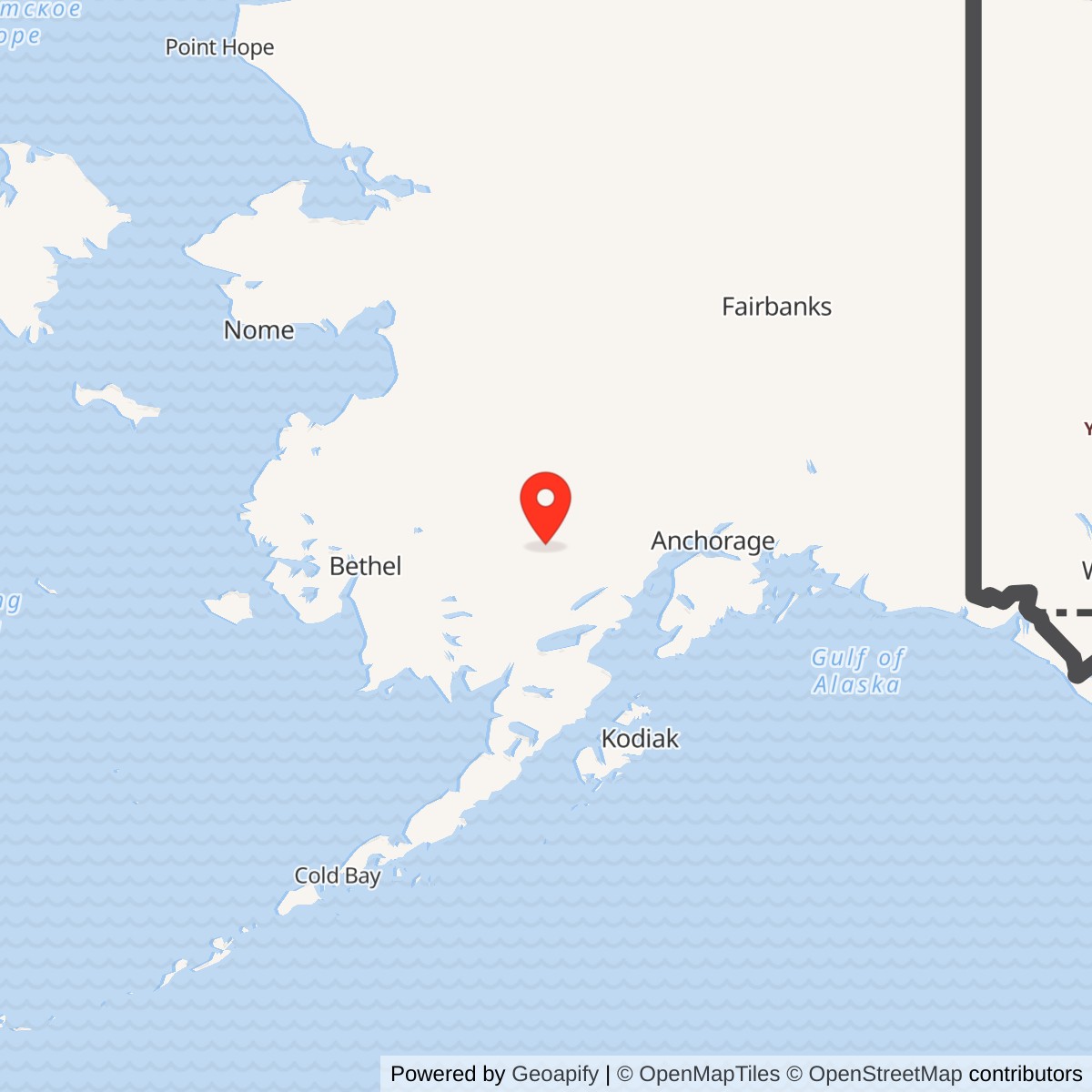
Longitude: -155.596471
Sparrevohn Air Force Station was a staffed aircraft warning post in Alaska's mountain interior and remains an operating Long Range Radar Site. Its history includes two substantial missions at one installation: an upper-camp radar station that watched air approaches to Alaska, and a physically separate White Alice Communications System relay on the same 1,180-acre military property. The relay carried communications between three other Alaska stations. It was not itself an air-search radar, and the present radar is not a surviving White Alice antenna. A lower camp with an unusually demanding airstrip supported both missions. The abandoned White Alice ground is now an environmental-control area while the radar mission continues. [1] [2] [6]
- Role
- Former staffed Alaska aircraft-warning station and continuing long-range radar site, with a former White Alice communications relay on the same property.
- Radar
- Temporary AN/CPS-5, then AN/FPS-3 and height-finders; AN/FPS-117 minimally attended radar introduced in 1984.
- White Alice
- Direct paths to Big Mountain, Aniak, and Tatalina; first operation recorded October 26, 1957; withdrawal occurred across 1978-1979.
- Land and access
- 1,180 reported installation acres on a mountain ridge, with an Upper Camp, former relay area, Lower Camp, and airstrip. Air access only.
- Coordinate note
- DEC point 61.104912 N, 155.609914 W, NAD83, marks the former OT004 White Alice environmental area, not a surveyed center of the entire radar installation.
- Present condition
- Radar site active in 2025 with four to five year-round contractors. Former White Alice OT004 area is controlled and inspected for residual PCB-contaminated soil.
Setting, Land, and Access
The installation occupies the crest and southeastern slope of a ridge informally called Sparrevohn Mountain, about 18 miles south of Lime Village. The 2009 Air Force environmental decision places its 1,180 acres in portions of eight survey sections in Townships 12 North, Ranges 35 and 36 West, Seward Meridian. This is the reported installation area, not the acreage of the former White Alice component. The ridge rises to about 3,302 feet. Upper Camp held the radar and associated equipment. Lower Camp held housing, fuel, water, warehousing, and the landing strip. Roads connected the separated areas. The White Alice plant stood on another portion of the ridge, roughly one mile from the top camp. The Opportunity Site, a third radio location, was not the White Alice terminal. [5]
The radar installation remained federal land in the 2009 Air Force decision, bordered by Bureau of Land Management land to the east, north, and west and State of Alaska land to the south. The Air Force retained the site for military use and restricted access by outsiders. The former relay area was within this operating property; its cleanup boundary should not be mistaken for the boundary of the entire 1,180-acre installation. [5]
Sparrevohn was air-access only, with no road to Lime Village or a regional supply system. Aircraft delivered construction equipment, food, fuel, people, and later maintenance material. The 1988 Corps inventory describes survey equipment parachuted in during 1951, including a load dropped on the wrong summit. An attempt to lower a D-9 tractor by helicopter ended when the cable failed. The airstrip had a severe grade and a cliff at one end. Corps accounts give conflicting figures of 12 degrees and 12 percent for its slope, so neither figure is used here as a verified runway specification. Building and supplying the strip, road, and upper camp remained a demanding part of the station's operation. [2]
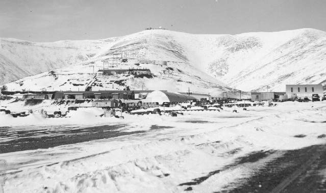
The mountain climate and divided layout shaped station life. People and supplies had to move between the landing strip and radar summit in severe weather. A tramway between Lower and Upper Camp was completed in 1957, operated until 1981, and was then dismantled. Road travel remained the alternative. [1]
Construction and First Radar Coverage
Alaskan Air Command selected Sparrevohn in 1951 to close a gap in interior Alaska radar coverage. The 813th Engineer Aviation Battalion began the difficult construction in June. A later Air Force-sponsored AC&W history says a mobile AN/CPS-5 provided temporary, intermittent coverage by December 1951. It describes construction completed in December 1952, followed by a decision to replace temporary works with more permanent ones. The 2009 Air Force cleanup decision calls the installation activated in 1952. A 1994 Corps management plan instead dates formal AC&W operations to March 1954. Temporary detection, activation, and formal operations were different stages in the station's opening. [1] [5]
Detachment F-15 of the 626th Aircraft Control and Warning Squadron initially operated the site, with its parent at Fire Island. In December 1952 the local detachment became the 719th Aircraft Control and Warning Squadron. The AC&W history gives the new squadron an assigned strength of 174 and initially places it under the 531st Aircraft Control and Warning Group, with later higher-headquarters changes. The 1994 Corps study calls the later unit the 719th Aerospace Defense Squadron. The site was known as an Air Force Station during its staffed AC&W years and later as a Long Range Radar Site under contractor-supported operation. [1] [3]
Radar Equipment and Air-Defense Work
The initial AN/CPS-5 was mobile and could not provide the stable, year-round coverage expected of a permanent warning post. An AN/FPS-93 search set and AN/FYQ-9 data system arrived in 1965 and gave the post semiautomatic data-handling capability. [1]
The 1994 Corps account says the 719th transmitted radar information to the King Salmon regional control center. Search and height data were therefore part of a wider Alaska interception system, not an isolated local display. A remotely situated station required dependable communications to pass plots and orders. Early high-frequency radio was vulnerable to atmospheric conditions; an experimental very-high-frequency link also served the area from the separate Opportunity Site. The 2009 decision dates that VHF experiment broadly from 1952 to 1958. Neither system should be confused with the later, purpose-built White Alice tropospheric-scatter circuits. [3] [5]
The separate height finders mattered because the rotating search radar located targets horizontally but did not by itself give controllers a reliable altitude. The later AN/FPS-117 combined three-dimensional surveillance in one minimally attended system. This changed both the radar picture and the station's staffing needs. [1]
White Alice at Sparrevohn
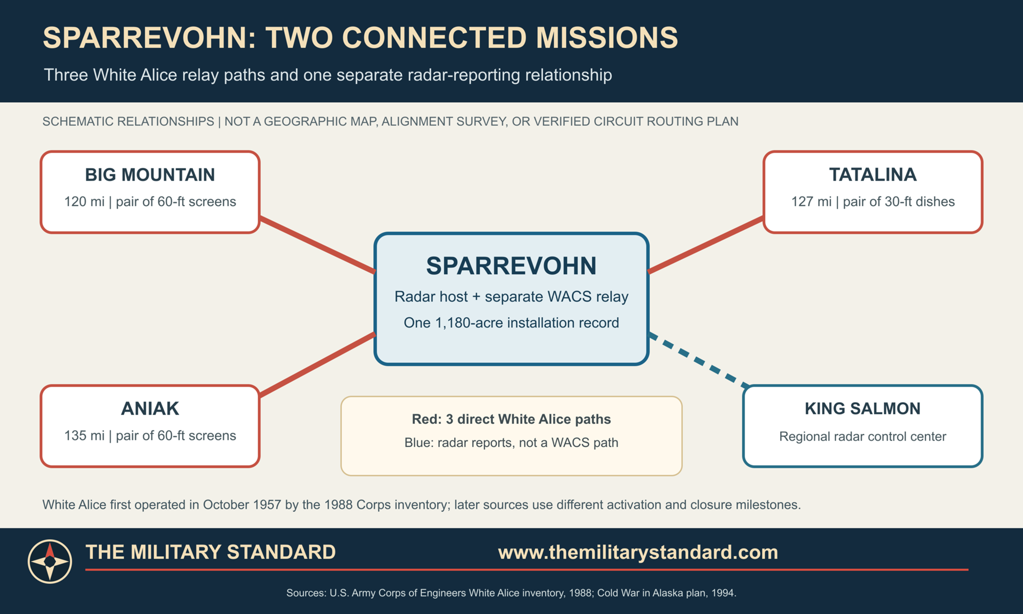
Sparrevohn's White Alice station was a three-way tropospheric-scatter relay physically associated with the radar installation but distinct from its antenna and transmitter pads. The 1988 U.S. Army Corps inventory documents three paths. Two 60-foot billboard reflectors faced Big Mountain, about 120 miles away. A second pair of 60-foot reflectors served Aniak, approximately 135 miles away. A pair of 30-foot dishes served Tatalina, approximately 127 miles away. The station thus joined the southwestern and interior branches of the White Alice network and gave the radar site a more reliable communications route. The reflectors, feed systems, relay equipment, power plant, fuel storage, and living facilities were a substantial installation component, not a small accessory mast beside the radar. [2]
Big Mountain was a standalone relay, Aniak was another White Alice communications site, and Tatalina combined a relay with its own AC&W radar mission. Sparrevohn was therefore a junction between several routes, where a failure could disrupt more than one onward path. That role helps explain the investment in large antennas, independent power, and resident technicians at an air-only station. [2] [3]
The Corps inventory dates White Alice construction to 1956-1957 and states that Sparrevohn became operational on October 26, 1957. Its station profile records a 5,760-square-foot composite building, a 5,200-square-foot dormitory for 16, and three petroleum tanks with 6,200 barrels of total capacity. Those 16 dormitory places describe the communications plant's own accommodation, not the full AC&W station population. The 1988 inventory also reports modifications to the composite building in 1960 costing more than $1.6 million. The facility's high electrical load and remote fuel supply later became important in the cleanup record. [2]
White Alice's large metal billboard reflectors were not radar search dishes. They directed radio energy toward the lower atmosphere so that a small scattered fraction reached a matching receiver far beyond ordinary line-of-sight range. At Sparrevohn, the Big Mountain and Aniak paths each used two large screens, while the Tatalina circuit used two smaller round dishes. The four billboards and two dishes gave the relay six antennas in all. [2]
Sources give different White Alice start and end dates. The 1988 Corps station profile records October 26, 1957 as the opening day, while the Air Force-sponsored AC&W history gives February 1958 as activation. The 1994 Corps plan dates deactivation to 1978; the AC&W history places it in May 1979. The 2009 Air Force decision describes operation from 1957 to 1979, and a later report says dismantling began in 1980. Together these dates describe initial service, subsequent activation accounting, a phased withdrawal, and later removal, although the last traffic date for each circuit remains unknown. [1] [2] [3] [5] [6]
The Opportunity Site was a separate, earlier VHF location about a mile east of Upper Camp. A transmitter pad lay roughly 500 feet northeast of Upper Camp, with the Opportunity Site about one mile farther east. Both were distinct from the White Alice relay. The ridge thus held successive communications systems alongside, but physically apart from, the radar antennas. [6]
People, Airlift, and Station Life
Sparrevohn's remoteness made aviation, fuel, and housing essential parts of the defense mission. A weather interruption could delay relief personnel and equipment. Aircraft had to use a sloping, mountain-framed landing strip; personnel then faced the road or tram to reach the top camp. A circa-1966 Eleventh Air Force photograph shows how much lower-camp construction was needed beneath the summit. The 1988 Corps account says Sparrevohn was among the most difficult and costly White Alice sites to build. The earlier radar construction alone cost about $1.5 million according to the AC&W history. [1] [2]
Personnel counts changed greatly over time. The 719th had 174 assigned positions in 1952. The 2009 Air Force decision describes approximately 130 military personnel during the White Alice operating period. After the 1977 RCA Services support contract, station staffing fell from more than 100 to 27, primarily radar operations positions. Roughly 80 military positions disappeared with the communications transition. Contractor operations eventually reduced the permanent contingent to about ten by the mid-1980s and four to five year-round contractors in 2025. The figures refer to different stages of Sparrevohn's operation. [1] [3] [5] [6]
The radar and relay together required a substantial resident community, while airlift and the tram shaped everyday logistics. Later automation and satellite communications ended the need for that larger military population, although a small contractor contingent remained to support the operating radar. [1] [6]
Satellite Replacement and the Minimally Attended Radar
During the late 1970s an Alascom satellite earth terminal replaced White Alice communications at Sparrevohn. The Corps dates this change to the 1978 withdrawal, while the AC&W history records a May 1979 deactivation. Dismantling followed from 1980, and the old communications buildings and antennas had been removed by the mid-1980s. The radar station itself did not close. In 1977 RCA Services had begun providing contract support. A Joint Surveillance System upgrade completed in 1982 allowed radar information to travel by satellite to the Regional Operations Control Center at Elmendorf. When that control center became operational in 1983, the 719th was inactivated and military staffing withdrawn. Sparrevohn became a Long Range Radar Site in the Alaska Radar System. [1] [2] [3] [6]
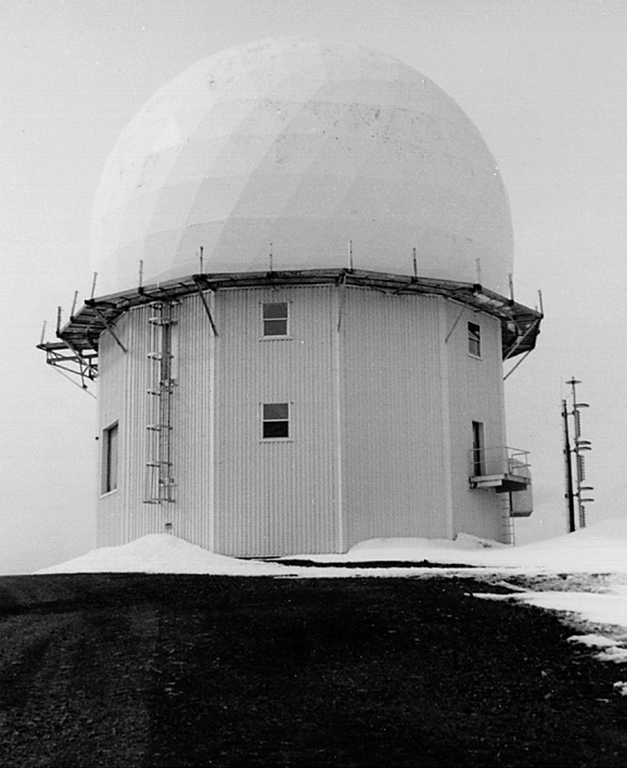
In June 1984 the Seek Igloo modernization installed a minimally attended AN/FPS-117 radar with integrated search and height-finding capability. It replaced the operational need for the earlier separate search and height-finder arrangement. A new double geodesic-dome composite facility supported the reduced contractor workforce and equipment. Eleventh Air Force archive photographs show the 1984 construction and radar radome. Old AC&W and White Alice facilities were demolished in 1985. [1] [3] [5]
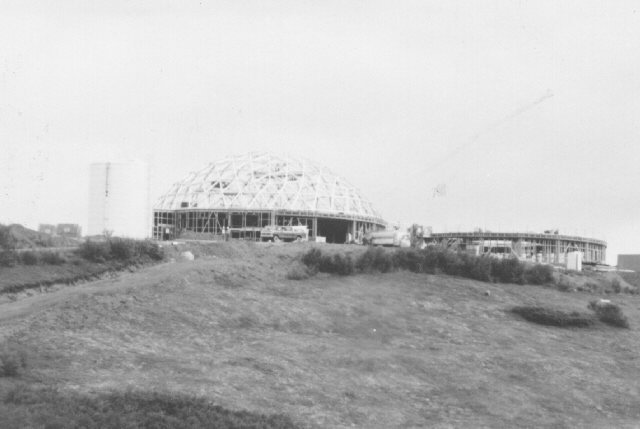
As of the October 2025 Air Force management report, Sparrevohn remained an active radar installation with four to five year-round contractor personnel. The report calls the radome the only remaining Upper Camp building and notes several warehouses at Lower Camp. A 2010 inventory had also documented an AC&W-era warehouse, pump station, storage building, weather station, airfield, road system, and seven minimally attended radar-era properties. The runway, roads, radar plant, and remote supply chain remain integral to the active site. [1] [6]
Environmental Record and the Former White Alice Ground
Decades of air-only supply, fuel storage, power generation, and equipment maintenance left environmental problems at several parts of Sparrevohn. The 1985 Air Force records search began the formal investigation. The former White Alice relay was designated OT004; the Lower Camp fuel area and other station facilities were evaluated separately. The relay's tanks, generators, oil-filled electrical equipment, and later demolition debris were part of its military communications history. [4] [5] [6]
Investigations in the 1990s found PCB contamination beneath the former White Alice facilities. In May 2009 the Air Force selected a remedy based on continued industrial use and institutional controls rather than removal of every affected soil area. Signs, limits on residential use and excavation, and regular inspections protect the covered former relay ground. Lower Camp's separate petroleum and groundwater problems require their own controls and monitoring. [5] [6]
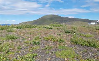
An August 2025 inspection found the OT004 warning signs in place, no obvious erosion or disturbance, and a mostly vegetated site with some partly buried inert metal. A power cable serving the active radar crossed the former relay area. Annual inspections remained recommended. The continued controls are an enduring consequence of the White Alice mission even though its antennas and buildings are gone. [6]
Surviving Landscape, Location, and Interpretation
Sparrevohn's surviving military function is its radar and air-supported logistics, not the demolished White Alice screens or original large AC&W camp. Historical photographs show the upper and lower camps around 1966, the 1984 radar modernization, and a radar radome. A 2025 Air Force photograph shows the former relay footprint as a vegetated ridge area. Together these views reveal the change from a large resident station to a minimally attended radar site. [1] [6]
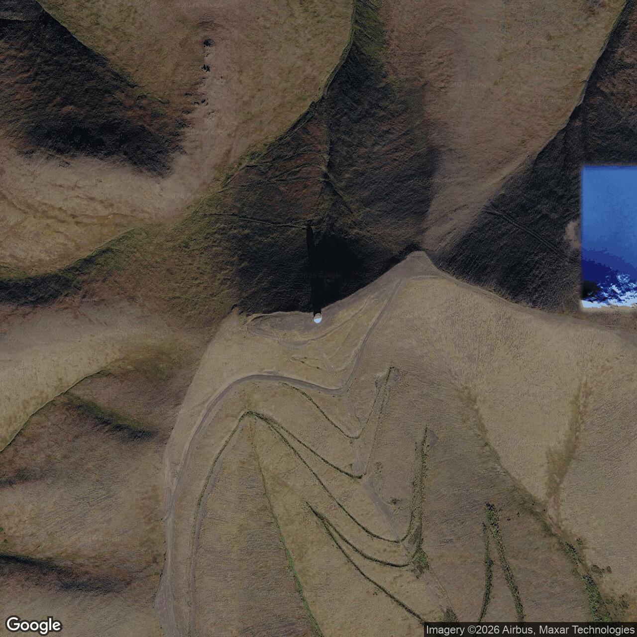
Alaska DEC places the OT004 former White Alice area at approximately 61.104912 N, 155.609914 W, NAD83. This is a point for that component, not a surveyed center of the entire 1,180-acre radar installation, its runway, or the current radar antenna. Published coordinates for the wider station differ substantially. [5] [7]
Sparrevohn illustrates the evolution of Alaska air defense without becoming a story of simple abandonment. Temporary radar coverage in 1951 grew into a staffed AC&W station. White Alice then tied its air-warning mission to Big Mountain, Aniak, and Tatalina. Satellite communications, data transmission to Elmendorf, and AN/FPS-117 modernization reduced the resident workforce and removed the old relay. The former communications ridge remains under managed cleanup controls, while the radar site continues as part of Alaska's long-range warning system. [1] [2] [3] [6]
Chronology
- 1951 Alaskan Air Command selected Sparrevohn to close a radar-coverage gap; the 813th Engineer Aviation Battalion began construction in June.
- 1951-12 A mobile AN/CPS-5 provided temporary and sporadic radar coverage according to the AC&W history.
- 1952 The Air Force later described the installation as activated; the temporary construction phase ended in December.
- 1952-12 Detachment F-15 became the 719th Aircraft Control and Warning Squadron.
- 1953-12 AN/FPS-3 search radar replaced the mobile AN/CPS-5.
- 1954-03 The 1994 Corps plan dates formal AC&W operations to March 1954.
- 1956-1957 White Alice relay construction established three paths to Big Mountain, Aniak, and Tatalina.
- 1957 AN/FPS-6 height finder was added; the tram connecting Upper and Lower Camp was completed.
- 1957-10-26 The 1988 Corps inventory records the White Alice relay operational on this day.
- 1958-02 A later AC&W history gives this as the White Alice activation month, reflecting a different milestone or unresolved date conflict.
- 1960 Modifications to the White Alice composite building reportedly cost more than $1.6 million.
- 1965 AN/FYQ-9 radar data system was installed.
- 1977 RCA Services began contract support, sharply reducing military staffing.
- 1978-1979 Satellite communications replaced White Alice; sources differ on 1978 versus May 1979 deactivation.
- 1980 Dismantling of the White Alice plant began according to the 2025 Air Force report.
- 1981 The upper-to-lower-camp tram was dismantled.
- 1982 Joint Surveillance System equipment enabled satellite transmission of radar data to Elmendorf.
- 1983 The Regional Operations Control Center became operational; the 719th was inactivated and the station became a contractor-operated LRRS.
- 1984-06 Seek Igloo modernization introduced the AN/FPS-117 minimally attended radar and new support domes.
- 1985 Unneeded original AC&W and White Alice buildings were demolished; Air Force environmental records search identified historic source areas.
- 1992-1999 White Alice soils were sampled and investigated for contamination.
- 2009-05 Air Force signed the OT004 White Alice cleanup decision selecting institutional controls for residual PCB-contaminated soil.
- 2025-08-05 Inspectors documented intact OT004 controls, remaining inert debris, and no observed erosion or disturbance.
- 2025-10 The Air Force's long-term management report documented an active radar site with four to five year-round contractor staff.
- 2026-05 Alaska DEC approved a further Sparrevohn long-term management work plan.
Information sources (7)
- PDFHistory of the Aircraft Control and Warning System in Alaska, Alaska Office of History and Archaeology, Sparrevohn section and archival images
Source for: Setting, construction, radar succession, units, tram, staffing, JSS and Seek Igloo transition, listed surviving structures, and three actual site images.
- PDFHistorical Overview and Inventory: White Alice Communications System, U.S. Army Corps of Engineers, 1988
Source for: Three Sparrevohn circuits, path mileages and antenna sizes, October 26, 1957 opening, buildings, fuel capacity, construction difficulty, and 1979 deactivation account.
- PDFThe Cold War in Alaska: A Management Plan for Cultural Resources, U.S. Army Corps of Engineers, 1994
Source for: March 1954 AC&W operations, 719th and King Salmon control relationship, 1978 White Alice closure account, Alaska Radar System role, and surviving landscape at the time of survey.
- PDFInstallation Restoration Program Phase I Records Search, AAC Southern Region, U.S. Air Force, September 1985
Source for: Installation setting, lower and upper camp, air-only support, and the 1985 identification of historic fuel and waste areas.
- PDFRecord of Decision, White Alice Communications System OT004, Sparrevohn LRRS, U.S. Air Force, May 2009
Source for: Installation sections, mission chronology, White Alice footprint and demolition, PCB investigation, selected remedy, continued federal control, and distinction among cleanup areas.
- PDF2025 Long-Term Management Report, Sparrevohn Long Range Radar Site, U.S. Air Force, October 2025
Source for: Current radar operation and staffing, remaining buildings, former White Alice and Lower Camp conditions, and present-day site photographs.
- WEBAlaska Department of Environmental Conservation, Sparrevohn LRRS OT004 White Alice Site, Hazard ID 694
Source for: NAD83 OT004 environmental marker and case status, dated regulator approvals, and continuing institutional-control record.