
Siskiyou County Air Force Auxiliary Field, Montague California
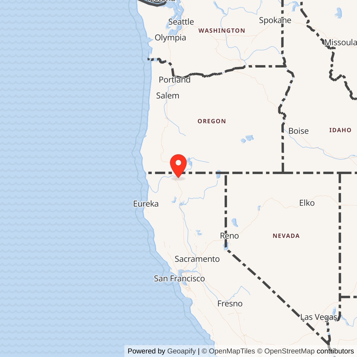
Longitude: -122.468108
Airport ICAO ID: KSIY
Official Base Website: Siskiyou County Airport
Current Role: Active non-towered Siskiyou County Airport with a 7,484-foot asphalt runway, Jet-A fuel, general aviation, emergency operations, county services, and a seasonal U.S. Forest Service tanker base.
Siskiyou County Air Force Auxiliary Field existed so that Air Defense Command fighters would not all be destroyed at their home bases.
The Air Force did not need another large permanent base in the Shasta Valley. It needed a remote runway where a small group of interceptors could land, refuel, rearm, receive maintenance, return to alert, and survive an attack on the principal air-defense installations of Northern California. Siskiyou County Airport offered a long runway, broad open terrain, distance from likely urban and military targets, and an established civil-airport operator willing to share the field.
The Cold War installation occupied selected portions of the existing county airport rather than the whole property as an exclusively military base. Siskiyou County retained civil ownership and joint use of the runway, while the Air Force leased exclusive-use parcels for the operations apron, shelters, maintenance, control, utilities, ammunition, roads, and related support. The field therefore combined civil aviation, Air Defense Command readiness, and emergency military use within one landscape.
The Air Force era began in 1962 and ended in 1972. Air Defense Command representatives met with Siskiyou County officials on 1962-09-13. A later U.S. Army Corps of Engineers archival history identifies 1962-10-22 as the date on which the Air Force acquired joint runway use and exclusive rights to selected airport areas. That same date became the opening day of the Cuban Missile Crisis interceptor dispersal.
Primary Air Defense Command records correct an important unit sequence that has been repeated incorrectly in some local summaries. On 1962-10-22, the 82d Fighter-Interceptor Squadron from Travis Air Force Base dispersed to Siskiyou County Airport. The 83d and 84th Fighter-Interceptor Squadrons from Hamilton Air Force Base dispersed to Kingsley Field in Oregon during the immediate crisis. Later Air Defense Command program documents paired the 84th Fighter-Interceptor Squadron at Hamilton with Siskiyou as the field's long-term programmed dispersal unit.
This distinction changes the interpretation of the site. Siskiyou first received F-102A Delta Daggers from Travis during the most dangerous days of the Cuban Missile Crisis. It was then developed as a permanent dispersal base for F-101B Voodoos associated with Hamilton's 84th Fighter-Interceptor Squadron. A 1963 program also listed the Kingsley-based 322d Fighter-Interceptor Squadron as a future Siskiyou dispersal user, but that planning relationship should not be mistaken for a documented permanent assignment or routine daily operation.
The Air Force began major improvements in December 1964. By 1965-12-17, the site included an improved runway and overrun, operations apron, approach lighting, mobile control tower, radar-support facilities, four aircraft shelters, maintenance dock, ammunition-storage magazine, utilities, and roads. Control of the Aircraft Dispersal Program at Siskiyou transferred to the 28th Air Division at Hamilton on 1965-10-01.
The program declined with the shrinking interceptor force. The Air Force reported the property excess on 1971-07-19 and terminated its county lease on 1972-05-15. The military facilities returned to county control or were absorbed into the airport landscape.
Siskiyou County Airport remains active as a non-towered public airport. Its current single asphalt runway measures approximately 7,484 by 150 feet. The county provides Jet-A fuel, controlled airfield access, general-aviation services, and space for a seasonal U.S. Forest Service tanker base operating during the wildfire season.
The Air Force installation was the same physical airport used by the Army Air Forces from 1942 through 1945, but it was a different service era with a different mission, command structure, aircraft, facilities, and strategic purpose.
Air Defense in the Missile Age
The interceptor dispersal concept emerged because the nuclear age made large air bases dangerously vulnerable.
During the early Cold War, Air Defense Command concentrated fighter-interceptor squadrons at bases connected to radar sectors and the Semi-Automatic Ground Environment system. These installations supported pilots, alert crews, weapons, maintenance, fuel, communications, and control. Concentration made daily operations efficient, but it also created an attractive target.
By the beginning of the 1960s, Soviet intercontinental ballistic missiles could threaten North American air bases with little warning. A successful first strike against interceptor home stations could destroy aircraft before they took off. The same attack might also disable Strategic Air Command bases, SAGE direction centers, communications, and radar facilities.
In June 1961, the Joint Chiefs of Staff directed North American Air Defense Command to develop plans that would increase the survivability of the continental air-defense system. Interceptor dispersal became one part of that response.
Air Defense Command issued Operation Plan 20-62, Fighter Dispersal/Increased Alert, on 1962-05-01. Its initial objective was to disperse one-third of the interceptors located in vulnerable target areas and establish an all-weather ability to support them away from their home stations.
The plan went beyond using a runway as an emergency landing site. Personnel, materiel, fuel, weapons support, maintenance, and control equipment had to be prepositioned. The ultimate concept called for four to six aircraft at a dispersal base on fifteen-minute alert, with enough support for repeated sorties.
Dispersal could not make an interceptor invulnerable. It forced an attacker to strike more locations, complicated targeting, and increased the chance that some aircraft would survive to intercept follow-on bombers after a missile attack.
Why Siskiyou Was Selected
Siskiyou County Airport fit the survivability requirement unusually well.
The Shasta Valley lay far from the dense military and urban target complex around San Francisco Bay, Sacramento, and the Central Valley. Hamilton Air Force Base, Travis Air Force Base, McClellan Air Force Base, and other installations supported major military missions. An attack on those areas would not necessarily affect a remote airport near Montague.
The Corps of Engineers archival history described Siskiyou as well outside likely target and fallout areas. That judgment should be understood as Cold War planning language rather than a scientific guarantee. Wind and fallout patterns could vary, and no location was completely safe during a nuclear war. The essential point was that Siskiyou appeared substantially less vulnerable than the primary bases.
The airport already had a long runway because the Army Air Forces had improved the civil field during World War II. The county continued using and maintaining it after 1945. Air Defense Command could therefore adapt a functioning airport rather than build a new one.
The surrounding terrain offered room for dispersal facilities and clear approaches. The runway elevation of approximately 2,648 feet imposed performance considerations, but its length gave fighters a useful margin.
The airport also stood near the California-Oregon corridor. Aircraft from Travis, Hamilton, Kingsley, and other western bases could reach it quickly. The field was remote without being inaccessible.
The disadvantage was limited support. Siskiyou had no permanent military housing, large depot, full hospital, or established interceptor squadron infrastructure. The Air Force would have to create enough facilities to recover and relaunch aircraft while relying on the home units for major maintenance and administration.
County Negotiations and Joint Use
Air Defense Command representatives met with the Siskiyou County Board of Supervisors on 1962-09-13.
The county controlled an airport whose civil value depended on runway access, general aviation, emergency activity, and public ownership. The Air Force needed military control over selected areas without eliminating the county mission. Joint use offered a solution.
Later archival histories identify 1962-10-22 as the date on which the Air Force leased or acquired joint use of the runway and exclusive use of additional parcels. The county's current historical page simplifies the sequence by referring to a lease beginning with the September meeting. The difference appears to reflect negotiation versus completed property rights rather than two separate military installations.
Under the joint-use arrangement, civil and military aircraft shared the principal runway. The Air Force controlled the apron, shelters, maintenance, ammunition, control, and utility areas required for the dispersal mission.
Shared use required coordination. Military alert operations could not ignore civil traffic, while county aviation could not interfere with armed interceptors, support vehicles, restricted areas, or emergency procedures.
The Air Force did not establish an independent municipality or conventional base-support community. Personnel arrived from parent units for alerts, exercises, maintenance, and other assignments. Civil ownership and airport operations continued around the military enclave.
The Cuban Missile Crisis
The first operational test came immediately.
On 1962-10-22, President John F. Kennedy prepared to announce that the Soviet Union had placed offensive missiles in Cuba. The possibility of direct confrontation and nuclear war caused Continental Air Defense Command and Air Defense Command to raise readiness and disperse interceptors.
Air Defense Command's historical study recorded that 147 interceptors from twenty-six squadrons moved to seventeen dispersal bases in approximately seven hours. The aircraft carried nuclear armament, the first time in the command's history that such dispersal flights had been ordered.
The 82d Fighter-Interceptor Squadron from Travis Air Force Base was assigned to Siskiyou in both the permanent dispersal plan and the actual 1962-10-22 movement. The squadron operated F-102A Delta Daggers during this period.
The F-102A was a single-seat, supersonic interceptor designed to operate within the SAGE air-defense system. Radar controllers could direct it toward unidentified or hostile aircraft. Its weapons were carried internally, reducing drag during high-speed interception.
The deployment turned a rural county airport into part of a nuclear-alert system. Aircraft arrived with aircrews and support requirements under crisis conditions, before permanent Siskiyou facilities had been constructed.
Air Defense Command's study noted that many dispersal bases were inadequately equipped in October 1962. The formal program was still developing, Canadian and Navy arrangements remained incomplete, and some squadrons had to use interim locations.
At Siskiyou, the crisis mission would have required parking, security, communications, fuel, maintenance, crew support, and rapid coordination with the county. The field had the runway but not yet the purpose-built shelters, apron, radar support, maintenance dock, and other facilities completed later.
The command-wide movement was not a training exercise. It was a real response to the possibility of war. The dispersal aircraft carried nuclear weapons, but the available source does not identify individual weapon serials, permanent storage arrangements, or a separate nuclear-weapons stockpile at Siskiyou. The safest interpretation is that armed aircraft brought their assigned weapons during the emergency rather than relying on a long-established nuclear-storage site at the county airport.
Correcting the Squadron Chronology
A later Corps of Engineers-derived local history states that aircraft from the 83d and 84th Fighter-Interceptor Squadrons at Hamilton moved to Siskiyou during the Cuban Missile Crisis and that the 82d Fighter-Interceptor Squadron became associated with the site in 1964.Primary Air Defense Command records show the opposite sequence for the actual 1962-10-22 dispersal. The 82d from Travis went to Siskiyou. The 83d and 84th from Hamilton went to Kingsley Field, Oregon.
The error likely developed because Siskiyou later became the programmed dispersal base for the 84th Fighter-Interceptor Squadron. A historian working backward from the established Hamilton relationship could easily project that later assignment onto the Cuban Missile Crisis.
Air Defense Command's 1963 program for the 1967 interceptor force listed the 84th Fighter-Interceptor Squadron at Hamilton, flying twenty-four F-101B Voodoos, with Siskiyou as its dispersal base. The same chart also listed the 322d Fighter-Interceptor Squadron at Kingsley with Siskiyou as a programmed dispersal base, showing that planning documents could assign more than one potential user.
The 1964 program for the 1969 force listed the 84th at Hamilton with eighteen F-101Bs and Siskiyou as its dispersal base. The 322d pairing had changed to Comox, British Columbia. This later program provides the clearest evidence that the enduring Siskiyou relationship belonged to the 84th.
The 83d Fighter-Interceptor Squadron was inactivated after the Cuban Crisis period to provide F-101B aircraft for other squadrons suffering attrition. The 84th's strength at Hamilton increased from eighteen to twenty-four aircraft.
The corrected history therefore identifies two principal operational relationships. The 82d FIS at Travis supplied the F-102A aircraft that actually dispersed to Siskiyou during the Cuban Missile Crisis. The 84th FIS at Hamilton became the later permanent programmed user, operating F-101B Voodoos.
The 322d FIS appears in a future-force planning chart and should be treated as a programmed relationship unless operational records confirm routine or crisis deployments to Siskiyou.
The F-102A Delta Dagger
The F-102A represented the first operational Air Force use of Siskiyou in 1962.
The aircraft was designed to intercept Soviet bombers before they reached major targets. Its delta wing, afterburning engine, radar, data-link capability, and internal weapons bay were intended for rapid response within a network of radars and direction centers.
The 82d Fighter-Interceptor Squadron operated F-102As at Travis Air Force Base. Travis was primarily associated with Strategic Air Command and Military Air Transport Service missions, which made its interceptor force especially important and especially vulnerable. Air Defense Command planning gave priority to squadrons collocated with strategic retaliatory forces or SAGE facilities.
Dispersing the 82d's aircraft reduced the chance that a strike on Travis would eliminate the whole squadron. Siskiyou gave the fighters a place to recover after launch or to wait on alert outside the primary target area.
The F-102A required more than fuel. Its radar, missile systems, electronics, tires, hydraulic systems, engine, and oxygen equipment needed trained support. A small deployment could operate for a limited period with mobile equipment, but a permanent dispersal capability required dedicated infrastructure.
The 82d's later history moved away from Siskiyou. It remained based at Travis until 1966, when the squadron and its F-102As transferred to the Pacific. The long-term Siskiyou program shifted toward Hamilton's F-101B force.
The F-101B Voodoo
The McDonnell F-101B Voodoo was a two-seat, all-weather interceptor capable of high speed, long-range flight, radar-controlled interception, and nuclear or conventional air-defense armament.
The aircraft entered Air Defense Command service in 1959. The 83d and 84th Fighter-Interceptor Squadrons at Hamilton converted to the F-101B after earlier interceptor types.
The Voodoo's two-person crew included a pilot and radar-intercept officer. The second crewmember managed radar and weapons functions during interception, an important advantage in poor weather or at night.
The F-101B was well suited to the Siskiyou dispersal concept because its home base at Hamilton lay in a likely target area and because the aircraft needed an all-weather alternate with adequate runway, control, maintenance, and weapons support.
The programmed 84th FIS relationship influenced the facilities built at Siskiyou. Four aircraft shelters matched the concept of maintaining a small alert force away from Hamilton. The maintenance dock supported limited repairs and servicing. Radar and control equipment helped aircraft operate when the county field lacked a permanent military tower.
The Air Force did not move the entire 84th squadron headquarters and community to Montague. Siskiyou remained a dispersal location. Aircraft, crews, weapons, maintenance personnel, security, and support could deploy there while the parent organization remained at Hamilton.
Permanent Dispersal Construction
Air Defense Command's 1962 emergency demonstrated that a runway alone was not enough.
The command's dispersal plan required aircraft to recover, turn around, and relaunch. That meant fuel, weapons support, maintenance, communications, control, security, weather information, crew facilities, emergency response, and access roads.
In December 1964, the Air Force began the principal Siskiyou improvement program. The work converted selected portions of the county airport into a purpose-built military dispersal complex.
Runway maintenance ensured that the pavement could support repeated interceptor operations. An overrun added safety margin beyond the normal landing surface. The operations apron gave the Air Force a controlled place to park and service aircraft away from civil traffic.
Approach lighting improved operations in darkness and reduced visibility. A mobile control tower provided local air-traffic coordination without requiring the county to operate a full permanent tower.
Radar-support facilities connected the site to air-defense control and helped manage local operations. Public summaries do not identify a large permanent search radar comparable to an Air Force station. The equipment should be understood as support for aircraft control and dispersal operations rather than a separate radar installation.
Four aircraft shelters protected interceptors and support activity from weather while reducing visibility and exposure. They were not hardened shelters designed to withstand a direct nuclear strike. Their purpose was practical protection, servicing, and readiness.
The maintenance dock allowed technicians to perform inspections and limited repairs. Major overhaul remained the responsibility of Hamilton, Travis, depots, and the parent squadron system.
Utilities supplied power, lighting, communications, water, and other services. Roads connected the Air Force enclave with the runway, county access points, maintenance areas, shelters, and ammunition site.
The ammunition-storage magazine supported armed alert operations. Its existence does not by itself prove permanent nuclear-weapons storage. The facility could hold conventional ammunition, missile components, support explosives, or other munitions. The primary dispersal plan anticipated nuclear capability, but detailed Siskiyou storage records have not been located.
The facilities were considered complete on 1965-12-17. By then, Siskiyou had become much closer to the permanent dispersal base envisioned in Air Defense Command planning.
Twenty-Eighth Air Division Control
The Aircraft Dispersal Program at Siskiyou transferred to the 28th Air Division at Hamilton Air Force Base on 1965-10-01.
The division controlled or supervised air-defense forces across the western region and connected interceptor squadrons with radar sectors, SAGE direction centers, communications, alert planning, and higher NORAD requirements.
This transfer placed the Siskiyou complex within a formal operational chain rather than leaving it as an improvised county-airport arrangement.
The 28th Air Division could coordinate the field with Hamilton's 84th Fighter-Interceptor Squadron, other western interceptor units, radar and control systems, and regional alert plans.
Day-to-day management still depended on local and parent-unit personnel. The county controlled civil operations, while Air Force detachments or visiting teams maintained military facilities and supported exercises or alerts.
No evidence establishes a permanently assigned numbered air-base squadron at Siskiyou. The field's personnel strength probably changed with exercises, maintenance requirements, and alert conditions.
Alert and Exercise Operations
The public record provides more detail about planned capability than about the frequency of later aircraft deployments.
Air Defense Command intended permanent dispersal bases to support aircraft on fifteen-minute alert and enable repeated sorties. The four Siskiyou shelters suggest a small deployed force consistent with that concept.
Crews could arrive for exercises, readiness inspections, or heightened alerts. Support teams had to prove that fuel, communications, control, maintenance, security, and weapons systems worked away from the home base.
A dispersal exercise tested more than flying. Personnel had to move equipment, establish command relationships, maintain classified communications, protect armed aircraft, coordinate civil air traffic, and sustain crews with limited local infrastructure.
The county airport remained open to civil aviation. Military use therefore required procedures for shared runway access and priority during emergencies.
The archival summary states that no regular training missions were scheduled during the immediate 1962 crisis period. That statement does not mean that the developed field remained unused afterward. It means the initial deployment was crisis dispersal, not a routine training detachment.
The surviving public history does not provide a complete log of later 84th FIS visits, alert exercises, aircraft tail numbers, or sortie counts.
Air Defense Network Relationships
Siskiyou County Air Force Auxiliary Field did not intercept aircraft independently.
Radar stations and SAGE direction centers detected and tracked unidentified targets. Controllers evaluated routes and assigned interceptors. Home or dispersed fighters received vectors through radio and data-link systems.
Hamilton and Travis provided the squadrons, aircraft, maintenance organizations, weapons expertise, training, administration, and major logistics. Siskiyou provided survivability and another launch location.
Kingsley Field in Oregon, Lemoore Naval Air Station, Fresno, Edwards, San Clemente, and other western dispersal sites formed parts of the same network at different times. Canadian bases expanded the system beyond the United States when political agreements allowed.
The field also depended on civilian infrastructure. Siskiyou County maintained the airport, roads connected it with Montague and Yreka, and regional utilities supported operations.
The dispersal mission was therefore a network function. Siskiyou mattered because it could receive aircraft from elsewhere and reconnect them to the larger air-defense system.
Decline of the Interceptor Force
By the late 1960s, Air Defense Command's manned-interceptor force was shrinking.
Aircraft production had ended earlier in the decade. Attrition reduced squadron strength. Some units transitioned to newer aircraft, moved, joined the Air National Guard, or inactivated.
Strategic priorities also changed. Intercontinental ballistic missiles had become the dominant nuclear threat, reducing the relative importance of defenses designed primarily against massed bomber attack. Radar, command, missile-warning, and fighter programs competed for resources.
Hamilton Air Force Base moved toward closure, and its interceptor units were reduced or relocated. The 84th Fighter-Interceptor Squadron eventually transitioned to the F-106 Delta Dart and moved away as Hamilton's mission contracted.
A dispersal base designed for a shrinking F-101B force became less necessary. Maintaining shelters, utilities, control equipment, pavement, ammunition facilities, and exclusive parcels at a remote airport imposed continuing costs.
By 1971-07-19, the Air Force had ended the Siskiyou dispersal program and reported the property excess to the General Services Administration.
Property Return and Closure
The Air Force terminated the county lease on 1972-05-15.
The date coincided with federal conveyance of remaining parcels and easements to Siskiyou County. The joint-use arrangement ended, and the military enclave returned to civil control.
Closure did not erase the facilities immediately. Aprons, shelters, roads, utility connections, pads, lighting, and the ammunition area could remain, be reused, or disappear gradually.
The county gained a runway and support landscape improved through two military eras. Civil aviation, emergency use, and firefighting benefited from infrastructure originally designed for bombers and interceptors.
No permanent Air Force unit remained at the airport after closure. Later military aircraft could use the field as transients, but that did not restore the dispersal installation.
The Air Force service era should therefore close in 1972 rather than 1971. July 1971 marks the end of the dispersal program and excess declaration. May 1972 marks termination of the legal Air Force property interest.
Physical Remnants
The active runway is the clearest surviving connection between the Army and Air Force eras.
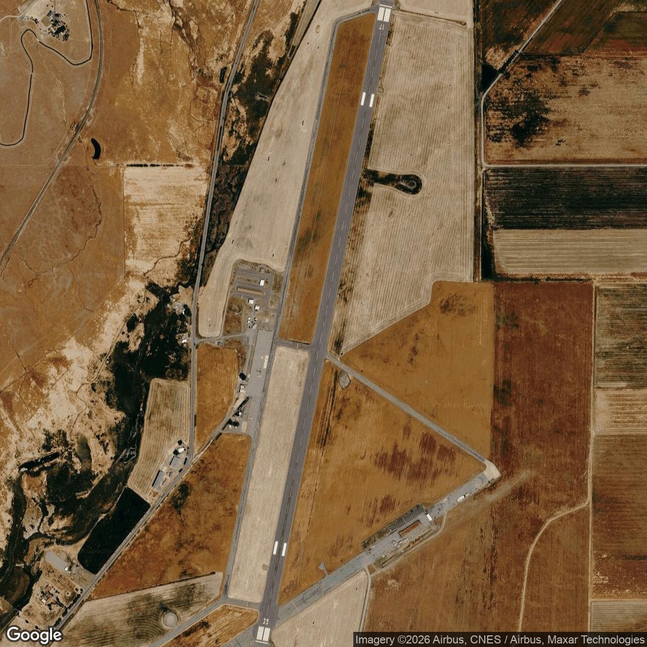
The Cold War operations apron, aircraft-shelter locations, maintenance area, roads, and support pads may remain in original or altered form. Aerial imagery can reveal geometric features that are difficult to recognize from ground level.
The four aircraft shelters were built for the dispersal program, but a complete current preservation inventory has not been located. Some structures may have been removed, modified, or incorporated into county airport uses.
The mobile control tower was intended to be movable or temporary and may not survive. Approach-lighting and utility systems have likely been replaced or integrated into later airport improvements.
The ammunition magazine and POL support areas require controlled historical and environmental investigation. They should not be treated as public ruins or entered without authorization.
Siskiyou remains an operating airport. Modern safety, security, and county access rules take priority over historical exploration.
Current Airport and Firefighting Mission
Siskiyou County Airport remains a public, non-towered general-aviation airport.
The county places it approximately three miles northeast of Montague and eleven miles east of Yreka. Electronic gates control north and south airfield access. The airport offers twenty-four-hour self-service Jet-A fuel.
The current Runway 17/35 is approximately 7,484 feet long and 150 feet wide. Its length continues to distinguish the airport from smaller local fields.
The airport supports private aircraft, emergency operations, county activity, transient aviation, and a seasonal U.S. Forest Service tanker base.
The tanker base usually operates between June and October. During major wildfire periods, aircraft can load retardant or support supplies, depart toward incidents in Northern California or southern Oregon, and return for additional missions.
This current mission is civilian and federal emergency work rather than Air Force activity. It nevertheless continues the site's long-standing role as a remote airport capable of handling larger aircraft when regional conditions become dangerous.
The airport must not be confused with Montague Airport / Yreka Rohrer Field, a separate smaller facility southwest of KSIY and closer to Montague.
Chronology
- 1961-06 The Joint Chiefs of Staff directed NORAD to develop plans to increase air-defense survivability, including interceptor dispersal.
- 1962-05-01 Air Defense Command issued Operation Plan 20-62, Fighter Dispersal/Increased Alert.
- 1962-09-13 Air Defense Command representatives met with the Siskiyou County Board of Supervisors concerning use of the airport as an interceptor dispersal site.
- 1962-10-22 Later Corps of Engineers archival history identifies the beginning of Air Force joint runway use and exclusive-use parcels.
- 1962-10-22 Air Defense Command implemented its Cuban Missile Crisis dispersal. Primary command records show that the 82d Fighter-Interceptor Squadron from Travis AFB dispersed F-102A aircraft to Siskiyou County Airport.
- 1962-10-22 The 83d and 84th Fighter-Interceptor Squadrons from Hamilton dispersed to Kingsley Field, Oregon, during the immediate crisis, not to Siskiyou.
- 1962-10 through 1962-11 Siskiyou participated in the national increased-alert and interceptor-survivability system during the Cuban Missile Crisis period.
- 1963-01-24 Air Defense Command's programmed 1967 force listed the Hamilton-based 84th Fighter-Interceptor Squadron, flying twenty-four F-101Bs, with Siskiyou as its dispersal base. The same program also listed the Kingsley-based 322d FIS as a potential Siskiyou user.
- 1963 The 83d Fighter-Interceptor Squadron was inactivated to offset F-101B attrition in other units, and the 84th's Hamilton aircraft strength increased.
- 1964-07-03 Air Defense Command's programmed 1969 force paired the Hamilton-based 84th FIS, with eighteen F-101Bs, to Siskiyou. The 322d's programmed dispersal base had changed to Comox.
- 1964-12 The Air Force began the principal permanent dispersal construction program at Siskiyou County Airport.
- 1964-1965 Work included runway maintenance, an overrun, operations apron, approach lighting, a mobile control tower, radar-support facilities, four aircraft shelters, a maintenance dock, utilities, ammunition storage, and roads.
- 1965-10-01 Control of the Siskiyou Aircraft Dispersal Program transferred to the 28th Air Division at Hamilton AFB.
- 1965-12-17 The principal Air Force construction program was considered complete.
- Late 1960s Siskiyou remained part of the western programmed interceptor dispersal system as the Air Defense Command force declined and reorganized.
- 1971-07-19 The Air Force ended the dispersal program and reported its Siskiyou property interests excess to the General Services Administration.
- 1972-05-15 The Air Force terminated the lease, and remaining parcels and easements were conveyed to Siskiyou County.
- Post-1972 Siskiyou County continued operating the airport for civil aviation, emergency use, and aerial firefighting.
- 2015-09-30 The Corps of Engineers FUDS inventory listed three response categories for Siskiyou County Airport J09CA0950 and a separate hazardous-waste project for Siskiyou POL Annex J09CA0092.
- Present Siskiyou County Airport remains active as a county-owned, non-towered general-aviation airport with Runway 17/35, identifiers SIY and KSIY, Jet-A fuel, and a seasonal U.S. Forest Service tanker base.
Information sources (10)
- PDFAir Defense Command Historical Study No. 27
The Fighter Interceptor Force, 1962-1964
- PDFNorth American Air Defense Command and Continental Air Defense Command
Historical Summary, July-December 1962
- PDFAir Defense Command Historical Study No. 15
The Air Defense Command in the Cuban Crisis
- WEBSiskiyou County
Siskiyou County Airport KSIY/SIY
- WEBCalifornia State Military Museum
Siskiyou County Airport, based on U.S. Army Corps of Engineers St. Louis District archival history
- PDFU.S. Army Corps of Engineers
Formerly Used Defense Sites Per State, California
- WEBTravis Air Force Base Aviation Museum
F-102A
- WEBNational Museum of the United States Air Force
McDonnell F-101B Voodoo
- WEBDVIDS
Air Defense Command interceptor dispersal during the Cuban Missile Crisis
- WEBFederal Aviation Administration data reproduced through AirNav
KSIY