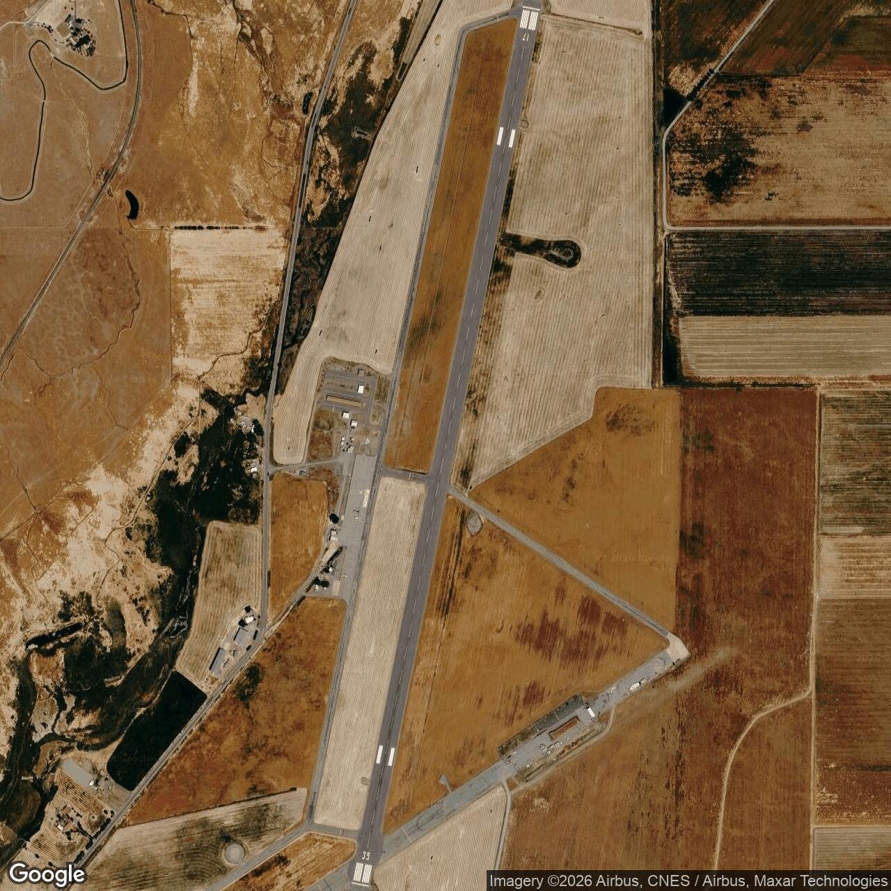
Siskiyou County Army Air Field / Siskiyou County Airport, California
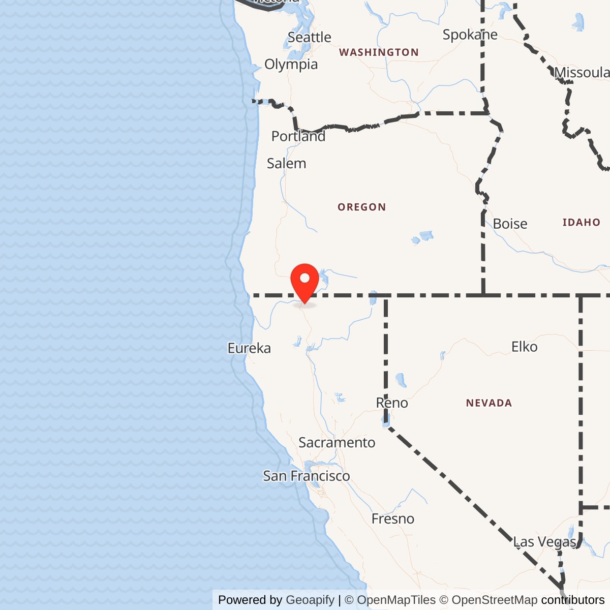
Longitude: -122.4681080
Airport ICAO ID: KSIY
Official Base Website: Siskiyou County Airport
Current Role: Active Siskiyou County Airport with a 7,484-foot asphalt runway, general aviation, Jet-A fuel, county services, emergency use, and a seasonal U.S. Forest Service tanker base
Siskiyou County Army Air Field was built for aircraft that might arrive in trouble.
The field occupied a broad, high-elevation valley surrounded by mountains and far from the main concentration of California military bases. That isolation limited its value as a large garrison, but it made the airport useful as a long-runway alternate for military aircraft crossing Northern California. Bombardment aircraft could land there, fighters and trainers could divert there, and damaged or weather-bound airplanes could find a paved refuge between Hamilton Field, Chico, Redding, Oregon, and the inland Pacific Northwest.
The airport began as a Civil Aeronautics Administration-funded civil field rather than a purpose-built Army cantonment. Later military property histories identify 1942-11-18 as the date the Army Air Forces leased approximately 985.44 acres. The Army extended and strengthened the original runways, added taxiways, installed night lighting and a power-control building, and enclosed the operating area with barbed-wire fencing. By the fall of 1943, the airport was functioning as a sub-base of Hamilton Field.
On 1944-05-01, the Army Air Forces reassigned Siskiyou County Airport to Chico Army Air Field. Under Chico, it remained an unmanned auxiliary and emergency field rather than joining the numbered sequence of Orland, Kirkwood, Vina, Campbell, and Oroville. Siskiyou County was not Chico Auxiliary Field No. 6. It was an existing county airport transferred into the Chico system because its long runways, northern location, and emergency value complemented the smaller fields used for repetitive local training.
The Army's use ended quietly. Chico transferred jurisdiction to Air Technical Service Command on 1944-10-15. Civilian alternate-airport use was approved on 1944-11-03. The command declared the airport no longer required on 1944-12-30, and it entered inactive military status on 1945-01-23. The Army Air Forces had never turned the site into a major post, and there was no large final unit departure. The field simply ceased to be necessary as wartime flying requirements changed.
The Air Force returned during the Cold War, but that was a separate service era. Beginning in 1962, Air Defense Command used Siskiyou County Airport as a fighter-interceptor dispersal site. The Air Force improved the runway, apron, approach lights, control and radar support, aircraft shelters, ammunition storage, utilities, and roads before ending the dispersal mission in 1971 and terminating the lease in 1972.
The current Siskiyou County Airport remains an active, non-towered public airport owned by Siskiyou County. Its single asphalt runway measures approximately 7,484 by 150 feet. The airport supports general aviation, emergency activity, county services, transient aircraft, and a seasonal U.S. Forest Service tanker base during the summer and early autumn fire season.
The field must also be distinguished from Montague Airport / Yreka Rohrer Field, a separate smaller airport southwest of Siskiyou County Airport and closer to Montague. Both can appear in aviation references under the Montague name, but the wartime military field is the present KSIY property northeast of town.
Shasta Valley Setting
The Shasta Valley is a broad interior basin in the far north of California. Mount Shasta dominates the southern skyline, the Klamath Mountains rise to the west, and volcanic uplands extend toward Oregon. The landscape provided long stretches of relatively level ground, but aviation there was never simple. Mountain weather could change quickly, winter brought snow and ice, and smoke, wind, fog, or low cloud could close routes that appeared clear only a short time earlier.
These conditions made an alternate field unusually valuable. Aircraft traveling north or south along the West Coast, or moving between inland military bases, could not assume that their planned destination would remain usable. A pilot with engine trouble or a formation caught by weather needed a runway large enough to accept military aircraft without requiring a long diversion through mountain terrain.
Montague developed as a railroad and agricultural community, while Yreka served as the county seat farther west. The airport's distance from major urban areas reduced congestion and gave military pilots a broad, unobstructed field. The same distance made a permanent station expensive. Housing, medical care, maintenance, recreation, and supply facilities would have required major construction, and the Army did not need another full cantonment in the Shasta Valley.
The military investment therefore concentrated on the aviation surface and the systems required to keep it available. Siskiyou County Army Air Field was valuable because it could receive aircraft, not because it housed large numbers of personnel.
Civil Origins and Federal Investment
The Civil Aeronautics Administration funded the original airport as part of a national program that improved civil aviation infrastructure while also strengthening national defense. During the late 1930s and early 1940s, federal agencies supported runways, airways, navigation facilities, and emergency fields that could be adapted quickly if the United States entered the war.
Siskiyou County Airport fit that dual-purpose model. It was publicly controlled, located along a strategic north-south corridor, and capable of expansion. Later airfield histories describe two original runways approximately 6,500 feet long. The Army extended or upgraded them to roughly 7,300 feet so larger military aircraft could operate with a greater safety margin.
Those historical dimensions must be treated cautiously because later reconstruction altered the field, and the current runway should not be projected backward as though it existed unchanged during World War II. What is clear is that the Army inherited a useful civil airport and improved it rather than starting with undeveloped farmland.
That existing foundation reduced the time required for military use. Engineers could strengthen pavement, improve taxiways, install lighting, and secure the field while aircraft operations continued elsewhere in the regional system. The county airport became military infrastructure without losing its underlying civil identity.
Army Lease and Military Improvements
Later military real-estate summaries identify 1942-11-18 as the Army Air Forces lease date and report a wartime site of approximately 985.44 acres. Because those details survive primarily in later summaries rather than a complete publicly available wartime deed file, they should be treated as well-supported but not absolute.
A lease gave the federal government rapid control without permanently transferring the entire property. Siskiyou County retained the underlying civil-airport relationship, which later simplified the return to civilian use.
The Army's improvements were practical and mission-focused. Runways were lengthened or strengthened for bombardment aircraft. Taxiways and aircraft-movement surfaces were improved. Night landing lights and a dedicated power-control building extended the field's usefulness after dark. Barbed-wire fencing reduced unauthorized access and helped keep livestock away from the operating area. Electrical and utility work supported the lighting and basic field operations.
The public record does not establish a large barracks district, major hospital, permanent depot, extensive hangar complex, or resident combat group. Later historical summaries specifically note the absence of housing. That limitation shaped everything about the installation. Personnel were likely temporary, rotating, or attached for specific duties such as lighting, security, inspection, communications, maintenance, and transient aircraft support.
The airport was therefore a military field without becoming a conventional base. Its principal asset was the runway system itself.
Hamilton Field Sub-Base
By the fall of 1943, Siskiyou County Airport operated as a sub-base of Hamilton Field. Hamilton, north of San Francisco, was one of the principal Fourth Air Force fighter installations on the West Coast. It supported fighter training, air defense, staging, and other regional missions involving aircraft such as the P-38 Lightning, P-39 Airacobra, P-40 Warhawk, and P-51 Mustang.
Hamilton required a network of dispersal, training, emergency, and alternate fields across Northern California. Siskiyou County Airport filled a gap near the Oregon boundary. It gave aircraft moving through the region a long runway far from the Bay Area and Sacramento Valley.
Being a sub-base did not mean that an entire Hamilton fighter group lived at Montague. The designation meant that Hamilton administered or controlled the field, scheduled its use, provided personnel or equipment when needed, and incorporated it into the wider operating system.
The lack of housing limited permanent activity. Aircraft could land, receive limited assistance, wait for weather, or depart after an inspection. Crews might find fuel or maintenance support depending on the circumstances, but Siskiyou did not offer the full services of a major base.
Its relationship with Hamilton is best understood as operational depth. Hamilton generated and supported the flying activity. Siskiyou County Airport gave that activity another place to land.
Bombardment-Aircraft Capability
The Army's decision to lengthen and strengthen the runways for bombardment aircraft did not make Siskiyou County Airport a bombardment training base. No permanent bomber group has been verified there. The improvement instead gave the field the ability to receive larger, heavier aircraft when necessary.
That capability mattered in the Shasta Valley. The airport stood at approximately 2,648 feet above sea level. Higher elevation reduces aircraft performance, especially during warm weather, and damaged or heavily loaded airplanes need more runway than a light trainer operating near sea level.
A bomber with an engine problem, a ferry aircraft diverted by weather, or a transport operating with limited power needed a generous safety margin. The longer runway made Siskiyou more than a local county field. It became a regional military alternate capable of accepting aircraft that could not safely use shorter auxiliaries.
The same physical advantage later attracted the Air Force. Jet interceptors required strong pavement, reliable approaches, and room for overruns. The Army's wartime investment gave the airport a foundation that remained strategically useful almost two decades later.
Emergency and Itinerant Use
Siskiyou County Airport's wartime mission combined auxiliary use, transient operations, and emergency recovery. Military flying generated constant mechanical and operational problems. Engines overheated, radios failed, fuel calculations changed, landing gear malfunctioned, and weather closed planned destinations.
A pilot in difficulty over Northern California had relatively few paved choices. Mountain valleys, forests, farms, and rough terrain offered poor alternatives. Siskiyou County Airport provided a visible, long, lighted landing surface.
The airport also served aircraft that were not in immediate danger. Crews could stop during ferry movement, cross-country navigation, inspection flights, or weather diversions. A formation could disperse rather than continue into unsafe conditions.
The field may not have been busy every day, but daily traffic was not the best measure of its value. An emergency airport provides strategic benefit through availability. The important fact is that the runway existed when an aircraft needed it.
A 1944 inspection reference to cattle mud on portions of the field illustrates both the rural setting and the limited permanent garrison. Livestock still affected the operating environment, something unlikely at a heavily occupied combat base. The Army had to maintain runway readiness in a place that remained partly agricultural and only lightly staffed.
Transfer to Chico Army Air Field
The transfer to Chico Army Air Field on 1944-05-01 placed Siskiyou within a different administrative network. Chico had opened as a basic flying school in 1942 and later shifted toward fighter replacement and combat training. Its principal numbered auxiliary fields were Orland No. 1, Kirkwood No. 2, Vina No. 3, Campbell No. 4, and Oroville No. 5.
Those fields were closely tied to Chico's local training pattern. Several used short square landing mats that allowed inexperienced pilots to land into the wind. They stood within easy flying distance of the parent school and absorbed repetitive pattern work.
Siskiyou County Airport was fundamentally different. It lay far to the north near Montague, began as a civil airport, used conventional long runways, and could accept larger aircraft. Its documented Chico-era mission emphasized disabled and itinerant aircraft rather than constant primary-training traffic.
The transfer therefore expanded Chico's operating reach without turning Siskiyou into another numbered practice field. It became an administrative auxiliary in the wider sense, but its strongest role remained emergency and transient support.
This distinction is why references to Siskiyou in histories of Kirkwood or the other Chico auxiliaries must be handled carefully. Siskiyou belonged to the Chico system for a period, but it did not share the same design, location, or routine training function.
Air Technical Service Command and Inactivation
On 1944-10-15, Chico transferred jurisdiction to Air Technical Service Command. That command managed maintenance, supply, depots, technical services, property, and the disposition of facilities no longer required by operational organizations.
The transfer signaled declining flying demand. The war was still underway, but Army Air Forces training requirements were changing, and some auxiliary fields no longer justified continued operational control.
Air Technical Service Command could preserve the airport temporarily while preparing it for civil use or disposal. The arrangement also separated Siskiyou from Chico's direct mission just months after the transfer from Hamilton.
On 1944-11-03, the Interdepartmental Air Traffic Control Board approved county use of the field as an alternate airport for scheduled commercial carriers. That decision allowed civilian aviation to return before the military lease and disposal process had completely ended.
The transition was gradual. Military control, county access, agricultural subleases, and inactive status overlapped rather than changing on one ceremonial date.
On 1944-12-30, Air Technical Service Command declared that the Army Air Forces no longer required the airport and recommended disposal. It entered inactive status on 1945-01-23, the most defensible closing date for the Army-era installation.
Assigned Organizations and Personnel
No independently based wing, group, or permanent squadron has been verified for Siskiyou County Army Air Field. Its principal organizational relationships were Fourth Air Force, Hamilton Field, Chico Army Air Field, and Air Technical Service Command.
Temporary or rotating personnel probably included airfield-operations staff, communications personnel, lighting and electrical technicians, security guards, maintenance and crash-response workers, inspectors, property officers, and transient aircraft crews. The absence of permanent housing supports the conclusion that staffing remained limited.
This distinction matters because parent-base relationships can be mistaken for permanent assignment. Hamilton fighter groups used a system that included Siskiyou, but there is no evidence that a Hamilton group transferred its headquarters or resident squadron strength to Montague.
Likewise, Chico controlled the field for several months, but Siskiyou did not become a resident Chico squadron base. Its military importance came from supporting other units rather than housing one of its own.
Role in the Regional Aviation Network
Siskiyou County Airport occupied a useful position between the Bay Area, Sacramento Valley, far northern California, and the Pacific Northwest.
Hamilton Field supplied fighter, air-defense, and administrative relationships. Chico supplied a training and emergency-field network. Redding Army Air Field provided another major northern military installation. McClellan Field and Sacramento Air Depot supported maintenance and logistics. Mather Field contributed training and navigation functions. Smaller auxiliaries at Willows, Orland, Kirkwood, Vina, Campbell, Oroville, and elsewhere distributed traffic and created additional landing options.
Farther north, Oregon and Washington fields continued the corridor. Siskiyou County Airport helped bridge the long distance near the California-Oregon boundary.
Its long runways meant that it could accept aircraft larger than those using some local auxiliaries. Its isolated position reduced congestion. Its lights made it usable at night. Its civil origin and county relationship made postwar return easier.
The field's value therefore came from where it sat within the network, not from the size of its permanent population.
World War II Significance
Siskiyou County Army Air Field did not launch a combat group overseas, operate a major flying school, or house a famous depot. Its history is quieter than that of Hamilton, Chico, or McClellan.
That does not make it insignificant. Large military aviation systems depend on alternate fields, emergency runways, and lightly staffed support locations. Major bases create units and aircraft, but auxiliary fields keep mechanical failures, weather changes, and fuel problems from becoming fatal accidents.
The Army improved a civil airport to bombardment-aircraft standards, integrated it with Hamilton, reassigned it to Chico, and preserved it through Air Technical Service Command during the transition back to civilian use.
Its success was measured by readiness. The runway was there, the lights worked, and aircraft could land when their original destination was no longer safe.
Postwar Civil Aviation
After Army inactivation, Siskiyou County resumed airport operations. The long runway supported general aviation, county services, firefighting, emergency activity, and larger transient aircraft.
The airport did not become a major airline terminal. Yreka and Montague remained relatively small communities, and highway travel improved. The civil mission developed around practical regional needs rather than large-scale passenger service.
Continued county use preserved the military-improved runway. Many wartime auxiliaries were abandoned, returned to agriculture, or erased by development. Siskiyou survived because it remained useful as a public airport.
That continuity later made Air Force reuse possible. The military did not have to recreate an airfield from nothing. It returned to a county airport whose long runway still offered strategic value.
Cold War Air Force Return
Air Defense Command returned to Siskiyou County Airport in 1962 for a mission unlike the World War II auxiliary role. The Cold War requirement was dispersal. Interceptor aircraft normally concentrated at major bases could be spread to remote fields during a crisis, reducing the chance that one attack would destroy the entire force.
Siskiyou County Airport was well suited to that concept. It lay far from major urban and military targets, had a long runway, and occupied relatively open terrain. Air Force representatives met with county officials on 1962-09-13, and later histories identify 1962-10-22 as the beginning of joint use and exclusive lease areas.
Within weeks, aircraft associated with the 83d and 84th Fighter-Interceptor Squadrons at Hamilton used the airport during the Cuban Missile Crisis period. By 1964-01-15, the 82d Fighter-Interceptor Squadron from Travis Air Force Base had become the principal associated unit.
The Air Force began major construction in December 1964. Improvements included runway maintenance and strengthening, an overrun, an operations apron, approach lighting, a mobile control tower, radar-support facilities, four aircraft shelters, a maintenance dock, utilities, roads, and an ammunition-storage magazine.
The principal work was considered complete on 1965-12-17. The dispersal program transferred to the 28th Air Division at Hamilton on 1965-10-01.
As interceptor forces declined, the Air Force reported the property excess on 1971-07-19 and terminated the lease on 1972-05-15. Remaining parcels and easements returned to county control.
This later period belongs to a separate Air Force history, but it confirms the durability of the Army-era investment. The same geography and runway capacity that made Siskiyou useful in World War II made it useful again during the Cold War.
Current Airport and Firefighting Mission
Siskiyou County Airport remains active as the county's largest public aviation facility. The official county site places it about three miles northeast of Montague and eleven miles east of Yreka. It is non-towered and uses identifiers SIY and KSIY.
The current asphalt Runway 17/35 measures approximately 7,484 by 150 feet. The airport provides Jet-A fuel, controlled gate access, general aviation services, emergency access, and space for larger transient aircraft.
A seasonal U.S. Forest Service tanker base operates during the summer and early autumn fire season. Northern California and southern Oregon face recurring wildfire threats, and the airport's long runway, open valley setting, fuel access, and proximity to forested mountain regions make it useful for aerial firefighting.
Tankers can load retardant or support equipment, depart toward fires, return for reloading or maintenance, and coordinate with ground resources. This is a civil and federal emergency mission rather than a military mission, but it continues the site's historic function as a place where large aircraft can operate safely in a remote region.
Environmental Legacy
The U.S. Army Corps of Engineers lists Siskiyou County Airport as a Formerly Used Defense Site under property number J09CA0950. The 2015 California inventory identified hazardous, toxic, or radioactive waste concerns, containerized hazardous-material concerns, and a military-munitions response project category.
The inventory also lists a separate Siskiyou Petroleum, Oil and Lubricants Annex under property number J09CA0092.
A FUDS listing does not by itself prove current danger or public exposure. It means the Department of Defense recognized former military use and evaluated or managed potential environmental responsibilities.
Common historical concerns at military airfields include fuel storage and handling, maintenance solvents, waste disposal, ammunition or munitions debris, electrical equipment, and contamination around support areas.
Physical Remnants
The runway is the most obvious surviving military resource. Later reconstruction changed its surface, but its length and continued use reflect the military requirement for larger aircraft.
Cold War improvements may survive in altered form as aprons, shelter pads, roads, utilities, approach systems, or other support features. A complete inventory of surviving World War II buildings has not been located.
The wartime lighting power-control building and temporary support structures may have been removed, repurposed, or replaced. Unlike a preserved cantonment, the military landscape at Siskiyou is best understood through runway geometry, engineering records, county documents, aerial photography, FUDS material, and surviving pavement.
Role in Post-World War II Conflicts
The Army installation had no role in the Korean War, Vietnam War, Persian Gulf War, Afghanistan, Iraq, or later conflicts because the Army Air Forces had inactivated the field in 1945.
The later Air Force dispersal mission belonged to the Cold War and Cuban Missile Crisis period. It supported continental air defense rather than overseas combat.
The current airport may receive transient military aircraft or participate in emergency exercises, but no permanent current Department of Defense assignment has been verified.
Role in the Wider Military Network
Siskiyou County Army Air Field linked civil aviation, Fourth Air Force, Hamilton Field, Chico Army Air Field, Air Technical Service Command, Siskiyou County, Air Defense Command, and the modern wildfire-response system.
The Civil Aeronautics Administration created the original infrastructure. The Army improved it. Hamilton incorporated it into a fighter and regional-support network. Chico used it as an unmanned auxiliary and emergency field. Air Technical Service Command managed the transition out of military use. Siskiyou County preserved the airport. The Air Force later adapted it for interceptor dispersal. The Forest Service now uses it as a seasonal tanker base.
Current Status
Siskiyou County Army Air Field is closed as an Army installation. The site remains active as Siskiyou County Airport, owned and operated by Siskiyou County.
The current airport supports general aviation, Jet-A fueling, county services, transient aircraft, emergency use, and seasonal wildfire tanker operations. No Army unit or Air Force interceptor detachment is permanently stationed there.
Chronology
- Pre-1942 The Civil Aeronautics Administration funded construction of Siskiyou County Airport as a public civil field in the Shasta Valley near Montague.
- 1942-11-18 Later military real-estate histories identify this as the Army Air Forces lease date.
- 1942-1943 The Army extended and strengthened the original runways for bombardment aircraft, added taxiways, installed night lighting and a power-control building, and enclosed the field with barbed-wire fencing.
- Fall 1943 Siskiyou County Airport functioned as a sub-base of Hamilton Field.
- 1944-05-01 The Army Air Forces reassigned the field from Hamilton to Chico Army Air Field.
- 1944-05 through 1944-10 The unmanned airport served primarily as an emergency landing field for disabled and itinerant Army aircraft.
- 1944-10-15 Chico transferred jurisdiction to Air Technical Service Command.
- 1944-11-03 The Interdepartmental Air Traffic Control Board approved county use as an alternate airport for scheduled commercial air service.
- 1944-12-30 Air Technical Service Command declared the field no longer required and recommended disposal.
- 1945-01-23 The airport entered inactive military status; portions were subleased for agricultural use.
- Post-1945 Siskiyou County continued civil airport operations, including general aviation and firefighting support.
- 1962-09-13 Air Defense Command representatives met with Siskiyou County concerning fighter-interceptor dispersal use.
- 1962-10-22 Later detailed histories identify the beginning of Air Force joint use and exclusive lease areas.
- 1962-10-22 Primary Air Defense Command records show that the 82d Fighter-Interceptor Squadron from Travis dispersed F-102A aircraft to Siskiyou during the Cuban Missile Crisis. The 83d and 84th FIS from Hamilton dispersed to Kingsley Field, Oregon.
- 1963-1964 Air Defense Command future-force program documents paired Hamilton's 84th Fighter-Interceptor Squadron, flying F-101B Voodoos, with Siskiyou as the long-term programmed dispersal unit.
- December 1964 The Air Force began major runway, apron, lighting, shelter, radar-support, utility, ammunition, and roadway improvements.
- 1965-10-01 The dispersal program transferred to the 28th Air Division at Hamilton.
- 1965-12-17 The principal Air Force improvements were considered complete.
- 1971-07-19 The Air Force reported the dispersal property excess as interceptor forces were reduced.
- 1972-05-15 The Air Force terminated its lease, and remaining parcels and easements returned to county control.
- 2015-09-30 The Corps of Engineers FUDS inventory listed three environmental project categories for Siskiyou County Airport and a separate POL annex property.
- Present Siskiyou County Airport remains an active county-owned, non-towered general-aviation airport with Runway 17/35, identifiers SIY and KSIY, Jet-A fuel, and a seasonal U.S. Forest Service tanker base.