
AN/FPS-79 Blue Nine Tracking Radar
- Type
- Fixed mechanically steered precision space and missile tracker
- Manufacturer
- General Electric
- Operational site
- Diyarbakir / Pirinclik Air Station, Turkey
- Documented service
- ADC table date July 1963; full capability by mid-1964; retired in 1997
- Mature baseline
- 432 MHz UHF; 84-foot dish in late Air Force documentation. Earlier published dimensions conflict.
Designation and Identity
The AN/FPS-79 was a one-of-a-kind American tracking radar built to turn the broad warning provided by the huge fixed-beam AN/FPS-17 installation in southeastern Turkey into precise measurements of missiles and spacecraft. Aerospace Defense Command's 1973 equipment master called the FPS-79 a "Long Range Radar (Sensor)," while its SPACETRACK table placed the radar at Diyarbakir, Turkey, beside the AN/FPS-17(XW1). A period U.S. radar handbook described the AN/FPS-79 even more narrowly: a fixed installation for a specific use, employed to track orbiting vehicles so their orbital paths could be determined. Those descriptions establish that the FPS-79 was not a general air-defense search radar. It was a specialized precision sensor whose value came from following selected objects once they had been detected or predicted.
The project name Blue Nine belongs to the development and acquisition history rather than to the formal JETDS designation. Later histories identify Blue Nine as the project that produced the AN/FPS-79 and link it to the Air Force 466L electromagnetic-intelligence system. The radar was built by General Electric, whose earlier high-power radar work had produced the AN/FPS-17 at Diyarbakir and the AN/FPS-80 mechanical tracker at Shemya, Alaska. The technical relationship among those systems is important, but the 1965 MIL-HDBK-162A entry for AN/FPS-79 explicitly states "Relation to similar equipment: None." That wording argues against casually treating AN/FPS-79 specifications as inherited AN/FPS-80 values, even though the two radars occupied comparable roles in the SPACETRACK network.
Only one operational AN/FPS-79 installation has been verified. It stood at the American-Turkish radar station near Diyarbakir, later known as Pirinclik Air Station. The site had begun in the mid-1950s as an intelligence-collection post built around AN/FPS-17 fixed-beam detection radar. The success of that radar against Soviet missile and satellite activity created a need for a steerable instrument able to lock onto a detected object and follow it accurately across the sky. The FPS-79 provided that second step. Together, the detection and tracking radars formed a complementary pair, with the AN/FPS-17 finding or cueing events and the AN/FPS-79 producing precise metric tracks.
This single-site history also explains why the AN/FPS-79 is unusually difficult to document from standard radar catalogs. It was not purchased in the quantities associated with continental air-defense radars, FAA surveillance systems, or tactical radars. The Air Force did not need a fleet of identical FPS-79s. It needed a highly capable tracking sensor at a geographic point from which Soviet launches from the southern USSR could be observed. As a result, changes made to the one fielded radar could materially change what later documents meant by "AN/FPS-79." Antenna dimensions, operating band descriptions, range claims, computing equipment, and even dates of operation vary across sources, and those differences must be preserved rather than flattened into a false universal specification.
Development Background
Diyarbakir became important because geography could substitute for access that American intelligence did not possess inside the Soviet Union. The early AN/FPS-17 at the station was aimed toward Soviet missile activity around Kapustin Yar. A 1964 CIA account of the Diyarbakir radar explained that the fixed-beam system quickly exceeded its original mission of simply detecting missile launches. Its data could be used to derive missile trajectories, identify satellite launches, calculate orbital ephemerides, and estimate booster performance. From 1955 through early 1964 the station accumulated hundreds of missile and satellite sightings, proving that remote radar intelligence could reveal technical information that would otherwise have been denied to the United States.
The AN/FPS-17 nevertheless had a fundamental limitation. Its beams were fixed in space. A target passed through those beams according to its trajectory, and the radar measured the event while the object was inside the coverage. The system could not mechanically swing a narrow beam to keep a selected missile, satellite, or reentry vehicle continuously under observation. That restriction mattered more as Soviet missile tests grew more sophisticated and the number of artificial objects in orbit increased. Intelligence analysts wanted accurate range, azimuth, elevation, and time histories over longer arcs so they could refine trajectories, estimate performance, and distinguish objects. Space-surveillance operators likewise needed precise tracks to maintain a growing catalog of satellites and debris.
The answer was to add a mechanical tracking radar at the same station. CIA authors Stanley Zabetakis and John Peterson wrote in 1964 that the success of the fixed-beam radar led to co-location of the AN/FPS-79, beginning in mid-1964. They specifically credited the tracker with adding the ability to estimate the configuration and dimensions of satellites or missiles and to observe the reentry of manned or unmanned vehicles. That statement is especially valuable because it was written while the new system was entering service and because it describes the intelligence purpose rather than simply listing equipment.
Other official and historical sources provide slightly different service dates. Aerospace Defense Command's 1973 SPACETRACK table gives July 1963 as the operational date associated with Diyarbakir's FPS-79, while a later technical-history article says the modified Blue Nine system went live late in 1963 and became fully operational in May 1964. The CIA article says the tracker began operating in mid-1964. These dates probably reflect different milestones such as installation, initial operation, test use, acceptance, and full mission capability. No single date is forced into all of those meanings. For chronology purposes, July 1963 is retained as ADC's table date, late 1963 as a reported live-operating milestone, and May to mid-1964 as the best-supported full operational period.
Manufacturer and Development Organizations
General Electric was the principal industrial organization behind AN/FPS-79. The company already had unusual experience with the Diyarbakir mission because it had fabricated and installed the AN/FPS-17 under an urgent Air Force program in the 1950s. Later space-surveillance histories identify General Electric as the builder of both Blue Nine and the related Blue Moon / AN/FPS-80 tracking effort. The Air Force's later Communications-Electronics Managers Handbook also records General Electric as the contractor providing operation and maintenance support and all three levels of maintenance for the AN/FPS-17 and AN/FPS-79 systems at Pirinclik. That long relationship makes GE both the original equipment contractor and a major sustaining contractor in the radar's mature life.
The government organizations behind the mission changed over time. Rome Air Development Center and the Air Force research and acquisition community had created the earlier high-power radar capability. Air Force Security Service organizations initially operated the intelligence radars at Diyarbakir, with later unit histories identifying the 6935th Radio Squadron, Mobile, as the operating organization before responsibility moved to Air Defense Command. ADC then incorporated the site into SPACETRACK and ultimately organized the 19th Surveillance Squadron to operate the station. Strategic Air Command assumed the space-surveillance mission after ADC's disestablishment, and Air Force Space Command later became the principal Air Force organization responsible for the network.
The intelligence customer was broader than any single command. The Diyarbakir station collected scientific and technical intelligence on Soviet missile and space activity, while the processed information supported Foreign Technology Division analysis and national intelligence users. By the late 1960s the same hardware also served the operational SPACETRACK / SPADATS mission of detecting, tracking, identifying, and cataloging man-made objects in space for NORAD. By the 1990s official Air Force documentation described the Pirinclik radars as Space Surveillance Network sensors performing space surveillance and object identification for U.S. Space Command, while the AN/FPS-79 also had a limited missile-warning mission.
Purpose and Operational Role
The AN/FPS-79 had two closely related roles. First, it was a precision intelligence instrument. Soviet missile and satellite launches could reveal booster performance, staging, payload behavior, orbital insertion quality, reentry characteristics, and other technical details. A steerable tracker could stay on a selected object longer than a fixed detection fan and deliver a denser sequence of range and angle measurements. The CIA's contemporary description makes clear that this was not generic traffic tracking. The purpose was to estimate physical and performance characteristics of missiles and spacecraft and to observe reentry events.
Second, the radar became an operational space-surveillance sensor. SPACETRACK linked radars and optical instruments to a central processing organization that maintained awareness of man-made objects in orbit. A 1968 Air Force history described the primary network as including the FPS-17 and FPS-79 at Diyarbakir, the FPS-17 and FPS-80 at Shemya, the FPS-49A at Moorestown Missile Tracking Site, Baker-Nunn optical cameras, a cooperative FPS-43, and supporting BMEWS radars. The network mission was to detect man-made orbiting objects and report them to NORAD. The AN/FPS-79 contributed precise tracking observations that helped refine orbits and maintain the space catalog.
By the late Cold War, the site's geography made its contribution difficult to replace. A National Security Space Road Map profile dated 1998 described Pirinclik as the only 24-hour-per-day eastern-hemisphere deep-space sensor and the only ground sensor able to observe actual deorbits of Russian space objects from its particular geometry. It emphasized early tracking of missiles and space launches from Tyuratam and surveillance of geosynchronous satellites over the eastern hemisphere. That profile preserves the rationale for the radar before closure, not proof of operation in 1998: its archive warns that budget and program decisions since 1997-1998 were not reflected, while the Defense Department had announced the station's closure in February 1997 and the operating squadron had inactivated that June. The source is useful for describing capability but its operational status label is stale.
The tracking radar also supported limited missile warning. The Air Force Communications-Electronics Managers Handbook says the primary mission of the AN/FPS-17 / AN/FPS-79 complex was collection of surveillance data on Soviet space and missile events and that the FPS-79 additionally performed limited warning of Soviet ICBMs launched against North America. In the 1990-1991 Persian Gulf crisis, later unit histories credit the Pirinclik radar with warning U.S. forces about Iraqi Scud missile launches. A detailed later account states that the radar was reoriented toward Iraq after U.S.-Turkish negotiations in August 1990 and used for impact-prediction support.
Technical Specifications and Source Conflicts
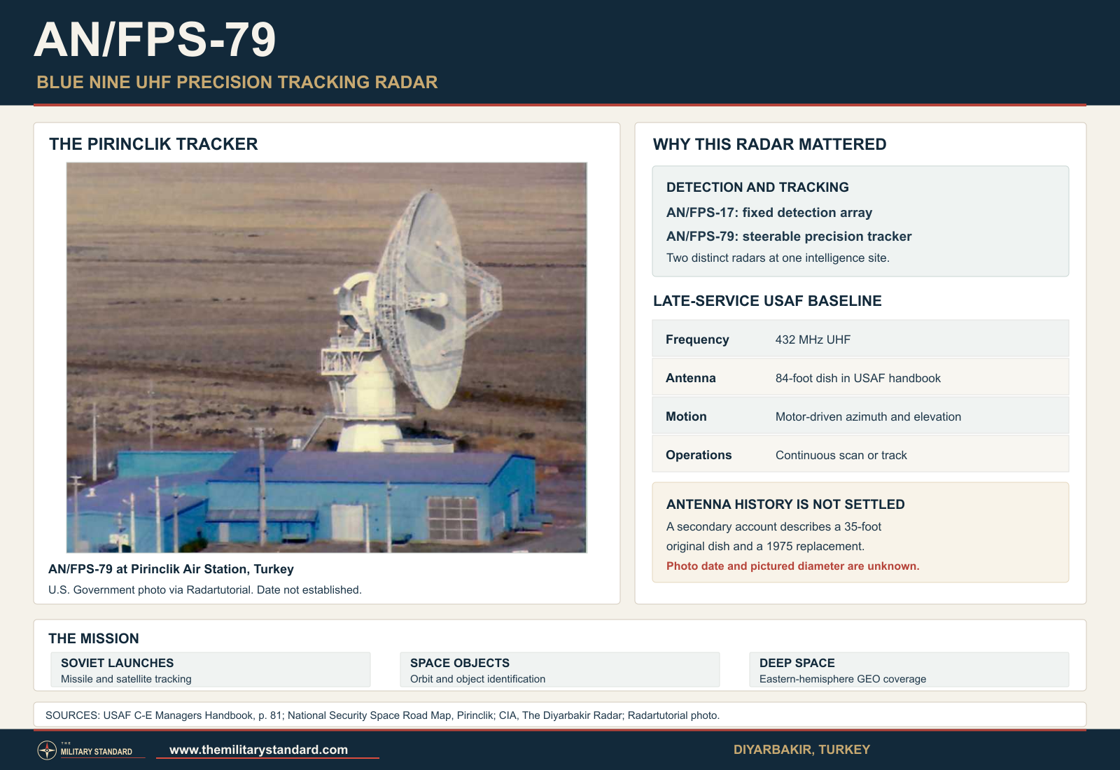
The most defensible mature frequency value is 432 MHz. The 1998 National Security Space Road Map says both Pirinclik radars operated at UHF, 432 MHz, and the later Air Force Communications-Electronics Managers Handbook likewise calls the AN/FPS-79 a mechanical UHF tracking radar. This 432 MHz figure is therefore entered as the mature operational baseline. A 2012 Aerospace America history, however, describes Blue Nine as operating in L-band. That wording conflicts with the later official UHF documentation. It may reflect a developmental configuration, a terminology error, or a later frequency change, but the sources located here do not establish which.
Antenna size is the largest physical conflict. Multiple Air Force-derived sources describe the mature AN/FPS-79 as having an 84-foot parabolic dish. The Communications-Electronics Managers Handbook explicitly says 84 feet. A declassified U.S. intelligence-history document preserved by the National Archives calls it an eighty-five-foot dish, which is close enough to be a rounded description of the same structure. The Aerospace America account also gives 84 feet. In contrast, Fundamentals of Astrodynamics, radar-reference websites drawing on that tradition, and later summaries describe a 35-foot dish and say an original antenna and pedestal were replaced in 1975. No primary engineering change order located reconciles the 35-foot and 84/85-foot descriptions.
The reported 1975 modification makes that discrepancy even more important. Secondary space-surveillance histories say the original AN/FPS-79 antenna had a variable-focus feed horn capable of creating a wider beam for acquisition and a narrow beam for precise tracking, and that the antenna and pedestal were replaced in 1975. A simple pre-1975 versus post-1975 size explanation does not fit all the evidence: a declassified intelligence history describes an approximately 85-foot dish at Diyarbakir in 1964, before the reported 1975 replacement. That account directly conflicts with the claim that the original dish was only 35 feet. No located engineering change order or dated, measured antenna photograph resolves whether a publication confused another radar, a feed or subassembly dimension, or separate configurations.
Mechanical steering is firmly supported. The late Air Force handbook describes the 84-foot dish as electrically driven by two motors in azimuth and two in elevation and capable of continuous operation in either scan or track mode. That arrangement distinguished the FPS-79 from fixed-beam surveillance radars. Rather than waiting for a target to cross a stationary fan, operators and computers could command the dish to slew to a predicted position, search a local volume, acquire the object, and then follow it as it moved. The radar's ability to produce precision angular measurements depended on the stiffness, control accuracy, drives, bearings, and calibration of that mechanical system.
Pulse compression is supported as a feature of the radar family in technical and historical descriptions, but exact waveform values for AN/FPS-79 were not found in the public primary documents located. Secondary descriptions state that pulse compression improved gain and range resolution. It would be unsafe to borrow the 2,000-microsecond coded pulse of the adjacent AN/FPS-17 or the waveform of AN/FPS-80 and assign it to AN/FPS-79 without a technical order. Pulse width, pulse-repetition frequency, peak RF power, published average RF power, transmitter tube type, receiver noise figure, beamwidth, and total site electrical demand therefore remain unresolved rather than being inferred.
Range claims vary so much that they must be separated by definition and era. A frequently repeated secondary figure gives a 24,000-mile tracking range, roughly geosynchronous distance, while the official National Security Space Road Map emphasizes deep-space and GEO surveillance without assigning that number. An Air Force history discussing 1967 modernization says existing radars had ranges under 4,000 nautical miles, a very different figure that probably concerned practical mission performance against particular targets and configurations. These are not necessarily contradictory in the radar-equation sense because range changes drastically with radar cross section, integration time, geometry, signal processing, and whether the object is already precisely cued.
Altitude coverage is not a meaningful single ceiling for a deep-space tracker. The AN/FPS-79 followed ballistic missiles, near-earth satellites, reentry objects, and, in mature service, geosynchronous spacecraft. A conventional air-defense entry such as "65,000 feet" would misrepresent the mission by many orders of magnitude. The correct description is space tracking from ballistic-missile trajectories through near-earth and deep-space orbits, with geosynchronous surveillance explicitly documented in late service. The exact minimum elevation angle, azimuth travel, elevation travel, slew rate, acceleration, and tracking precision were not located in source-controlled form.
How the System Worked
The AN/FPS-79 operated most effectively as part of a two-radar system. The AN/FPS-17 at Diyarbakir projected fixed detection beams across selected Soviet launch corridors. When a new missile or satellite crossed those beams, its measured range, beam location, and time provided an initial estimate of where the object was going. Operators and processing equipment could then point the AN/FPS-79 toward the predicted track. Once the tracker acquired the object, the mechanically steered dish followed it and produced more continuous range and angular measurements than the detection fence alone could provide.
The cueing relationship was not automatic magic. A target had to be recognized as interesting, its likely path estimated, and the tracker directed into the correct region soon enough to acquire it. Contemporary descriptions of the space-surveillance network emphasize that sensors were scheduled and tasked. When no new Soviet launch demanded immediate attention, the AN/FPS-79 could track cataloged space objects according to tasking supplied by the central space-surveillance organization. This dual pattern, event-driven intelligence collection plus scheduled catalog maintenance, allowed a unique national intelligence instrument to become a regular operational sensor without abandoning its specialized mission.
A variable-focus feed, described in secondary technical literature for the original system, would have supported this workflow by offering a wider beam for acquisition and a narrower beam for tracking. Wide-beam search reduces pointing sensitivity and increases the chance that a somewhat uncertain target prediction will fall inside the illuminated volume. Narrowing the beam after acquisition improves angular discrimination and tracking precision. The principle is consistent with the radar's known mission, but because the detailed feed design and post-1975 configuration are not available in a primary technical order here, the exact beamwidths and mechanical arrangement remain source-qualified.
Pulse compression was another way to reconcile competing requirements. A long coded pulse can carry substantial energy, increasing the probability of receiving a usable echo from a distant object. Processing the coded return can compress that energy in time, improving range resolution compared with an uncoded pulse of the same duration. The neighboring AN/FPS-17 famously used coded pulses, and later descriptions also associate pulse compression with AN/FPS-79. The exact coding scheme and compression ratio of the FPS-79 are not established in the located documentation, but the feature fits the requirement to make precise measurements at very long range.
Data processing evolved substantially during the radar's lifetime. Early 1960s radar tracking depended on then-modern real-time computing and on central analysis outside the site. Historical accounts of Blue Nine describe computer-controlled processors. During the late 1960s the Air Force specifically funded improved rapid on-site processing for the Diyarbakir radar, reducing the delay between observation and usable tracking data. By the 1990s the Air Force handbook said VAX computers provided the AN/FPS-79's data-processing capability. The radar therefore survived partly because its computing and data handling could be modernized even though the basic mechanical antenna concept remained from the early space age.
Typical Installation and Physical Layout
The verified AN/FPS-79 installation was a purpose-built fixed radar facility inside the larger Diyarbakir / Pirinclik station. Period and later photographs show a large parabolic tracking antenna on a substantial pedestal rising above or immediately adjacent to a support building. The pedestal carried the azimuth and elevation drive machinery, while the building below provided protected space for transmitters, receivers, power equipment, control electronics, processing equipment, maintenance work, and environmental support. Because the radar was not transportable, the concrete foundations, alignment, power plant, communications, and control spaces were as much a part of the system as the dish.
The 1965 MIL-HDBK-162A entry lists the principal component groups as Transmitter Group, Modulator Group, Power Supply Group, Receiver Group, Antenna Group, Antenna, and Pedestal. It frustratingly leaves dimensions and weights blank and says a technical description was not available. That absence itself is historically revealing. The equipment was still specialized and security-sensitive enough that a broad service handbook could acknowledge the major groups without publishing the data normally provided for other radar sets. The handbook also confirms that the AN/FPS-79 was a "fixed installation; specific use," which matches the singular Diyarbakir deployment.
The AN/FPS-79 stood near the much larger fixed AN/FPS-17 structures. Declassified imagery of Pirinclik shows the visual contrast between the giant fixed detection antennas and the steerable dish. Together they formed a sensor site, not two independent radar stations. The detection complex, tracking radar, operations center, communications paths, power distribution, security facilities, and support cantonment were linked operationally. By the 1990s the site's radar mission also depended on long-haul data circuits connecting observations to the U.S. Space Surveillance Network and command centers.
The station itself required a military support population beyond the radar crew. Air Force organizations provided administration, security, logistics, communications, vehicle support, civil engineering, medical services, billeting, and host-nation coordination. The radar's unusual overseas location also meant that U.S.-Turkish agreements were operationally significant. The same diplomatic relationship that allowed the Cold War intelligence mission later mattered when the United States sought to direct the radar toward Iraqi missile activity during the Gulf crisis.
Integration with SPACETRACK, SPADATS, and the Space Surveillance Network
The AN/FPS-79 entered service as SPACETRACK was evolving from an improvised collection of sensors into a more integrated military space-surveillance architecture. In the early years, radar and optical stations belonged to different commands and agencies, and no single organization possessed every required capability. Air Force histories describe a network that relied on cooperation among radars built for missile intelligence, BMEWS, optical Baker-Nunn cameras, and specialized trackers. The AN/FPS-79 was valuable precisely because it already existed for another high-priority mission and could also produce measurements needed for satellite cataloging.
As SPADATS matured, observations from Diyarbakir contributed to the central process of correlating detections, identifying objects, determining orbits, and maintaining a catalog. The AN/FPS-79 was a contributing sensor rather than the entire system. Its observations had greatest value when combined with measurements from other geographic locations because orbital determination improves as different sensors see the same object at different times and geometries. Diyarbakir's eastern-hemisphere position filled a geographic gap that sensors in North America could not cover at the same moment.
This network relationship helps explain why late official sources could describe the Pirinclik complex as indispensable even though the radar was decades old. Space surveillance is not simply a contest for the newest antenna. Geometry, longitude, latitude, continuous availability, communications, and tasking all matter. A unique sensor in Turkey could observe Russian launches early, see eastern-hemisphere deep-space objects, and watch deorbits that might be poorly placed for continental U.S. radars. The 1998 road-map assessment warned that losing Pirinclik would significantly affect early tracking from Tyuratam and GEO surveillance over the eastern hemisphere.
The AN/FPS-79 also interacted with space-based missile warning. Defense Support Program satellites could detect the infrared signature of missile launches, while a ground radar could provide precise trajectory data after acquiring the object. During some Cold War contingencies, ground sensors including Diyarbakir were part of augmentation plans intended to preserve warning and characterization capability if space-based coverage degraded. This layered architecture anticipated the modern practice of combining infrared warning, radar tracking, optical surveillance, and centralized computing rather than relying on a single sensor type.
Variants, Modifications, and the 1975 Rebuild
No formal AN/FPS-79A, AN/FPS-79B, or other JETDS suffix was located in the controlling ADC source or period handbook. The equipment should therefore remain a single formal designation unless a primary technical order establishes otherwise. That does not mean the radar stayed physically unchanged. A system serving more than three decades necessarily accumulated major modifications in electronics, data processing, communications, controls, and probably its antenna assembly.
The most important documented change occurred around 1975. Secondary space-surveillance histories say the original antenna and pedestal were replaced. Unit histories also say the entire Diyarbakir radar site was placed in caretaker status on 1975-07-27 and returned to operations in October 1978. The overlap in dates strongly suggests that major modernization occurred around the shutdown, but no source located here directly states that the caretaker period existed solely to rebuild the FPS-79.
Late computing modernization is better documented. The Air Force's fiscal 1968 history says OSD funded modifications to two SPACETRACK radars and that the Diyarbakir improvement added rapid on-site data processing. By the 1990s, VAX computers were the radar's processing platform. Air Force Space Command histories also note broader upgrades at Diyarbakir that eventually supported geosynchronous tracking. These changes allowed the same mechanical radar to remain useful as the space catalog and required observation accuracy grew far beyond the environment of 1964.
The antenna-size conflict cannot be assigned safely to the 1975 modification. Some technical literature describes a 35-foot dish and a 1975 replacement, but a declassified intelligence history already describes an 85-foot dish in 1964, and later Air Force documentation gives 84 feet. The 1964 account rules out treating 35 feet as a proven original diameter and 84 feet as a proven replacement diameter. Without engineering drawings or dated, measured photographs, the physical reason for the conflict remains unresolved.
Systems It Replaced and Systems That Replaced It
The AN/FPS-79 did not simply replace the AN/FPS-17. It complemented it. The fixed detector remained necessary because its fan beams watched a large planned launch corridor and could alert the site to events. The tracker then supplied precise measurements. The closest technological predecessor was the General Electric experience embodied in Blue Moon / AN/FPS-80 at Shemya and other precision tracking radar work, but the period MIL-HDBK entry's "Relation to similar equipment: None" prevents describing the FPS-79 as merely an AN/FPS-80 variant.
No single radar directly replaced AN/FPS-79 at Pirinclik when the U.S. site closed. By 1997 the wider Space Surveillance Network included powerful phased-array radars, GEODSS optical sites, Cobra Dane, PAVE PAWS, PARCS, and upgraded mechanical or optical sensors at other locations. The Defense Department said closure was possible because of general European base drawdown and improvements in space-surveillance technology. The capability loss nevertheless left a geographic gap. Air Force history notes that the Transportable Optical System was sent to Moron Air Base, Spain, where it achieved initial operational capability in 1998 and later became the Moron Optical Space Surveillance system, in part to compensate for loss of Pirinclik's coverage.
The planned replacement history is also instructive. In the late 1960s the Air Force examined options for modernizing SPACETRACK and at one point contemplated replacing the Diyarbakir radars with an AN/FPS-85-class capability in the 1970s. That plan did not become the fielded history of the site. The AN/FPS-79 instead survived through electronics and processing upgrades.
Known U.S. Military Locations Using the AN/FPS-79
Diyarbakir Air Station / Pirinclik Air Station, Turkey, is the only verified operational location. ADC's own SPACETRACK table identifies Diyarbakir with FPS-79 tracking radar and FPS-17(XW1) detection radar. Later Air Force and national space-surveillance documents continue to place AN/FPS-79 at Pirinclik through the 1990s. No evidence supports operational AN/FPS-79 deployment at Shemya, where the mechanical tracker was AN/FPS-80 or AN/FPS-80(M), or at any continental U.S. radar station.
This uniqueness is important for future site histories. References to "the AN/FPS-79" and "the Pirinclik tracker" normally describe the same physical equipment lineage, but the physical configuration changed over time. A future history of Pirinclik should therefore treat the equipment as a long-lived installation component rather than assume that every photograph or technical statement depicts the 1964 baseline. Likewise, a future AN/FPS-80 history must not inherit Pirinclik data simply because the two trackers had General Electric origins and similar missions.
Operational History: Soviet Missile and Space Intelligence
The FPS-79's defining Cold War work was tracking Soviet missiles and spacecraft. Diyarbakir's location put it south of key Soviet launch corridors and within radar geometry useful against activities at Kapustin Yar and, in the mature network, Tyuratam. A new event detected by the FPS-17 could be handed to the FPS-79, allowing analysts to extend the observation arc and obtain accurate metric data. Those measurements helped reconstruct trajectories, infer propulsion and staging behavior, determine orbital insertion, and study reentry.
The radar also supported observation of Soviet manned and unmanned spacecraft. The 2012 Aerospace America account, drawing on declassified intelligence reporting, notes that Diyarbakir radar intelligence was used to confirm Soviet space mission milestones. In the broader national intelligence system, radar measurements from Turkey were combined with telemetry, signals intelligence, photography, optical tracking, and other sources. The AN/FPS-79 was thus not only a space catalog sensor but part of a measurement-and-signature intelligence chain focused on understanding foreign weapons and spacecraft.
This work was strategically significant because missile and space technologies overlapped. The same large booster families could place satellites in orbit or deliver strategic payloads on ballistic trajectories. Measuring a Soviet launch therefore informed both military-space intelligence and assessments of strategic missile capability. That duality is one reason Air Defense Command's space mission grew so rapidly in the 1960s and why the command was redesignated Aerospace Defense Command in 1968.
Operational History: Modernization and the 1975-1978 Hiatus
By the late 1960s the growing number of objects in orbit stressed the original SPACETRACK architecture. The Air Force's fiscal 1968 history recorded a requirement for new system improvements and OSD funding for modifications to two radars. At Diyarbakir, the key improvement was rapid on-site processing. Faster local computation reduced dependence on slow off-site reduction and allowed observations to be turned into usable tracks more quickly. The change shows the direction of radar evolution: the antenna remained important, but computers increasingly determined how much operational value could be extracted from each echo.
The site then experienced a major interruption. Unit history places Diyarbakir in caretaker status beginning 1975-07-27, with normal radar operations suspended until October 1978. Secondary equipment histories place antenna and pedestal replacement in 1975. When operations resumed in October 1978, the radar remained within the Aerospace Defense Command era. The transfer of ADCOM space-surveillance responsibilities to Strategic Air Command came in late 1979, and the 19th Surveillance Squadron was assigned to SAC's 7th Air Division on 1979-12-01. ADCOM was inactivated in 1980. The radar therefore returned before, not after, the command transition; it later served the more mature Space Surveillance Network under SAC and Air Force Space Command.
The radar's return also demonstrated the cost of geographic uniqueness. A sensor in Turkey could not be replaced simply by assigning more work to a radar in Florida or Alaska because viewing geometry was different. The United States therefore retained and modernized the old mechanical tracker even as newer phased arrays came online elsewhere. That practical fact explains why AN/FPS-79 survived far longer than many 1960s radar types.
Operational History: Space Debris and the 1986 SPOT 1 Ariane Breakup
One of the clearest demonstrations of Pirinclik's geographic advantage came on 1986-11-13. An Ariane third stage associated with the SPOT 1 launch fragmented violently in orbit, creating hundreds of detectable pieces. Later space-surveillance histories report that the debris cloud would not pass over the continental United States for more than eight hours, but the FPS-79 at Pirinclik detected the breakup debris within minutes. That early observation gave the Space Surveillance Center valuable warning and track information before North American sensors had direct geometry on the event.
The incident is important because it shows the radar doing a mission that its 1960s designers could not have regarded as the primary justification for Blue Nine. The problem was no longer only Soviet launch intelligence. By the 1980s orbital debris itself had become a hazard to spacecraft and a burden on the catalog. A Cold War tracking radar had become a tool for space safety and environmental awareness in orbit. The event also illustrates why a globally distributed network remained necessary even after much more advanced individual radars were available.
Operational History: Operation Desert Storm
The Persian Gulf crisis gave AN/FPS-79 a direct wartime relevance outside its original Soviet target set. Unit histories credit the Pirinclik radar with alerting American forces to incoming Iraqi Scud missiles during Operation Desert Storm. A later detailed account states that the United States and Turkey agreed in August 1990 to reorient the AN/FPS-79 toward Iraq and place it in a missile-monitoring mode. In that arrangement, Defense Support Program satellites supplied rapid launch detection while Pirinclik's mechanical tracker contributed trajectory and impact-prediction information.
The broad concept is technically credible because infrared satellites and radar provide different parts of the warning problem. A satellite can see the hot plume of a launch very quickly, while precision radar tracking after acquisition can improve estimates of where the missile is heading. The surviving source trail for the specific 1990 reorientation is not as strong as for the Cold War SPACETRACK mission, so the history does not claim that every Scud warning depended on FPS-79 or assign a precise performance figure. It does establish that the radar's 1991 wartime use extended the equipment's operational story well beyond passive catalog maintenance.
Units and Organizations
Before AN/FPS-79 became an ADC-operated SPACETRACK asset, the Diyarbakir intelligence radars were associated with the 6935th Radio Squadron, Mobile, of the U.S. Air Force Security Service. That lineage reflects the site's original purpose as a scientific and technical intelligence collection station. In 1964 responsibility for the radars moved to Air Defense Command, bringing them more directly into the operational space-surveillance system.
ADC constituted and organized the 19th Surveillance Squadron to operate the Diyarbakir radars, with the unit organized on 1967-01-01. Its mission was detection and tracking of missile launches, deep-space surveillance, and tactical warning. Higher assignments changed as the Air Force reorganized its space mission, including the 73d Aerospace Surveillance Wing and Fourteenth Aerospace Force in the ADC era. After the 1975-1978 hiatus, the squadron operated under Strategic Air Command organizations and later under the new Air Force Space Command.
The unit became the 19th Space Surveillance Squadron in 1992, a title that more explicitly reflected the mission the radar had long performed. By the final years, the site belonged to the operational Space Surveillance Network and supported U.S. Space Command users. The AN/FPS-17 detection system was retired before the AN/FPS-79, leaving the mechanical tracker as the final major radar operating at the station until closure.
Contractor support remained important. The Air Force Communications-Electronics Managers Handbook said General Electric provided operation and maintenance support and all three levels of maintenance for the two Pirinclik radar systems. A 1996 Defense Department contract action later increased Lockheed Martin funding for fiscal 1997 operation, maintenance, and logistics support of Pirinclik sensor facilities. Those arrangements show how a unique, aging radar required sustained contractor expertise in addition to uniformed operators.
Role in the Wider Military Network
AN/FPS-79 was a small piece of equipment by fleet count but a disproportionately important node by geometry. The SPACETRACK / SPADATS network combined data from Turkey, Alaska, New Jersey, Florida, optical sites, BMEWS stations, test ranges, and other sensors. Each site saw a different part of the sky and provided a different measurement quality. Pirinclik's location near the southern USSR gave it early access to launch trajectories that other stations might not see until much later.
The radar's intelligence role also connected operational space surveillance to national technical intelligence. Measurements of Soviet missiles and satellites supported analysts concerned with booster performance, trajectory, dimensions, staging, and reentry, while the same observations could update orbital elements in the space catalog. This was a classic dual-use military sensor in the intelligence sense: one observation could support warning, catalog maintenance, and detailed foreign-system analysis at the same time.
By the 1990s the network had many sensors technologically more advanced than the FPS-79, yet the National Security Space Road Map preserved a preclosure assessment of Pirinclik as unique for eastern-hemisphere deep-space coverage and Russian deorbit observation. Its 1998 archived status label must not be read as evidence that the station remained operational after 1997. The site demonstrates a fundamental principle of surveillance networks. Sensor value depends not only on sensitivity and processing power but also on where the sensor is located and what parts of an event it can see.
Closure and Retirement
The AN/FPS-79 outlived the Cold War but not the post-Cold War base drawdown. The AN/FPS-17 detection radars at Pirinclik were decommissioned in December 1995, leaving the tracker to continue space-surveillance work for a short period. On 1997-02-06 the Department of Defense announced that operations at Pirinclik would end and that the installation would be returned to Turkey in September. The official release said the decision resulted from the general reduction of U.S. bases in Europe and improved space-surveillance technology. About 117 U.S. Air Force personnel were affected.
The 19th Space Surveillance Squadron inactivated in June 1997, and the sensor-support contract ran through the fiscal-year closeout period. Contemporary Air Force reporting listed Pirinclik as scheduled to close in September 1997. Later accounts commonly use 1997-09-30 as the final closure date. The exact day on which the FPS-79 transmitted its final operational track has not been established in a primary log located.
The network adapted rather than receiving a one-for-one replacement. Air Force historical analysis says the Transportable Optical System was moved to Moron Air Base, Spain, where it achieved initial operational capability in September 1998 and became the Moron Optical Space Surveillance system in 1999, partly filling the eastern coverage gap created by the FPS-79's decommissioning. More broadly, phased-array radars, GEODSS optical sensors, and improved processing reduced dependence on Pirinclik's mechanical tracker.
Preservation and Surviving Evidence
No complete preserved AN/FPS-79 has been verified. Later accounts of the base say the large radar reflectors were scrapped after closure and electronic equipment was removed, but the strongest public evidence for the equipment today is documentary and photographic rather than a museum artifact. Declassified intelligence records, Air Force histories, SPACETRACK tables, technical handbooks, site photographs, and late space-surveillance planning documents preserve a substantial record of the system.
The surviving photographs are especially useful because technical publications disagree about the antenna. The National Security Space Road Map includes an image identified as "Pirinclik AN/FPS-79." RadarTutorial publishes a clear photograph of the dish, feed structure, pedestal, and blue equipment building. A declassified National Archives intelligence-history document includes a black-and-white view of the Diyarbakir radar facility and describes the tracker as an eighty-five-foot dish. These images can be compared with dated station photographs to help reconstruct the 1964 and post-1975 configurations, but a full engineering reconciliation remains open.
The site itself also retained strategic significance after the American station closed. Turkey continued to control the area, and later missile-defense activity returned to the broader region. That later use should not be treated as continuation of the FPS-79 mission, however. The AN/FPS-79 belongs to a distinct Cold War and early post-Cold War surveillance era whose physical hardware appears not to have survived as an intact operational or museum system.
Legacy
The AN/FPS-79's legacy is disproportionate to its production quantity. One radar served for more than three decades as a bridge between missile intelligence and operational space surveillance. It followed Soviet missiles and spacecraft, helped maintain the growing orbital catalog, supported deep-space observation, detected a major orbital-debris event early, and was credited with warning support during the Gulf War. The system demonstrates how a specialized intelligence collector can become a long-lived operational sensor when geography and mission remain valuable.
Technically, the radar represents the mechanical-tracker stage between early fixed-beam missile radars and later electronically steered phased arrays. Its dish had to physically move in azimuth and elevation, and its ability to track depended on motors, pedestal mechanics, pointing controls, feed design, and increasingly sophisticated computers. Later phased arrays could shift beams electronically and follow many more objects, but the AN/FPS-79 remained useful because it could be upgraded and because its location could not be duplicated by electronics alone.
Historically, the equipment also illustrates why public radar specifications require source control. Official late documents say UHF at 432 MHz and an 84-foot dish. Other published technical accounts say L-band or 35 feet. Range descriptions vary from under 4,000 nautical miles in a 1960s modernization context to deep-space and geosynchronous capability in later service, with a secondary 24,000-mile figure widely repeated. Rather than choosing the most dramatic number, a defensible history preserves the configuration and definition problem. The AN/FPS-79 was a unique system whose decades of modification make source dates as important as the numbers themselves.
Chronology
- 1954-10 General Electric received the urgent contract that produced the original AN/FPS-17 missile-detection capability at the Diyarbakir site, creating the technical and geographic foundation for the later tracking radar.
- 1955-06-01 The first Diyarbakir AN/FPS-17 installation entered operation, establishing the long-term U.S. radar intelligence mission in southeastern Turkey.
- 1955-06-15 The Diyarbakir system recorded its first Soviet missile detection according to the later CIA history.
- 1957-10-04 Sputnik 1 demonstrated the strategic importance of satellite detection and accelerated the need for organized space surveillance.
- 1958 The Diyarbakir AN/FPS-17 complex received a major second-antenna and transmitter expansion, increasing its missile and satellite intelligence value.
- 1961-07 ADC's SPACETRACK system became operational as a formal network linking radar and optical sensors to a processing center.
- 1962-01-02 The unclassified AN/FPS-79 nomenclature card cited by MIL-HDBK-162A was dated on this day, showing the formal equipment designation existed before field operation.
- 1962-04-01 General Electric's AN/FPS-80 tracker at Shemya became operational, providing important contemporary experience in long-range mechanical space tracking.
- 1963-07 ADC's later SPACETRACK table gives July 1963 as the operational date associated with the Diyarbakir FPS-79.
- 1963-LATE A later technical history says Blue Nine went live at Diyarbakir late in 1963.
- 1964-03-01 The CIA's Diyarbakir history closed an AN/FPS-17 sighting count at this date after 508 reported incidents since 1955.
- 1964-05 A later technical history gives May 1964 as full operational capability for Blue Nine / AN/FPS-79.
- 1964-MID The contemporary CIA account states that the co-located AN/FPS-79 began providing its added tracking capability in mid-1964.
- 1964 Operating responsibility for the Diyarbakir radars transferred from the USAF Security Service operating organization to Air Defense Command.
- 1965-12-15 MIL-HDBK-162A listed AN/FPS-79 as a fixed, specific-use radar for tracking orbiting vehicles and determining orbital paths.
- 1966-11-01 The 19th Surveillance Squadron was constituted and activated administratively, before organization at Diyarbakir.
- 1967-01-01 The 19th Surveillance Squadron was organized to operate the Diyarbakir radar mission.
- 1967-07-26 The Air Staff documented new SPACETRACK requirements in a program change request as the orbital population and mission demands increased.
- 1967-10 OSD approved funding for selected SPACETRACK radar improvements, including rapid on-site processing at Diyarbakir.
- 1968-01-15 Air Defense Command became Aerospace Defense Command, formally recognizing the growing space component of its mission.
- 1968 The Air Force's fiscal-year history listed the FPS-17 / FPS-79 pair at Diyarbakir among the primary SPACETRACK radar sensors.
- 1971-04-30 The 19th Surveillance Squadron moved under Fourteenth Aerospace Force in the evolving ADC space-surveillance structure.
- 1974 PARCS joined the broader SPADATS network, increasing the number of advanced sensors available to the central space-surveillance system.
- 1975 Secondary equipment histories place replacement of the AN/FPS-79 antenna and pedestal in this year; the exact old/new antenna-size mapping remains unresolved.
- 1975-07-27 Unit history places the Diyarbakir radar station in caretaker status, suspending normal operations.
- 1976-10-01 The 19th Surveillance Squadron was assigned to the 21st Air Division during the caretaker period.
- 1978-10 Radar operations at Diyarbakir resumed after roughly three years in caretaker status.
- 1979-10 The Space Defense Operations Center replaced the earlier Space Defense Center as central command-and-control architecture continued to mature.
- 1979-12-01 The 19th Surveillance Squadron was assigned to the 7th Air Division under Strategic Air Command.
- 1983-05-01 The 19th Surveillance Squadron transferred to the 1st Space Wing.
- 1986-11-13 The FPS-79 detected debris from the fragmented SPOT 1 Ariane third stage within minutes, hours before the debris cloud passed over the continental United States.
- 1987 The radar mission transferred into Air Force Space Command as the service consolidated operational space forces.
- 1990-08 Later accounts state that U.S.-Turkish arrangements permitted the FPS-79 to be reoriented toward Iraq for missile-monitoring support after the invasion of Kuwait.
- 1991-01-17 Operation Desert Storm began; unit history later credited Pirinclik radar operations with warning U.S. forces of incoming Iraqi Scud missiles.
- 1991-10-01 The 19th Surveillance Squadron moved under the 73d Space Surveillance Group.
- 1992-05-15 The unit was redesignated the 19th Space Surveillance Squadron.
- 1994 Air Force Space Command continued modernizing central surveillance processing while Pirinclik remained an eastern-hemisphere sensor.
- 1995-12 The AN/FPS-17 detection radar at Pirinclik was decommissioned, leaving the AN/FPS-79 as the site's principal remaining surveillance radar.
- 1996-09-30 The Defense Department increased a Lockheed Martin support contract for fiscal 1997 operation, maintenance, and logistics of Pirinclik sensor facilities.
- 1997-02-06 The Department of Defense announced that operations at Pirinclik would end because of European base drawdown and improved space-surveillance technology.
- 1997-06-16 The 19th Space Surveillance Squadron inactivated.
- 1997-09 DoD planned return of the installation to Turkey during September 1997; contemporary Air Force reporting listed the station for closure.
- 1997-09-30 Later station histories commonly use this date for final U.S. closure of Pirinclik and retirement of the FPS-79 mission; a primary last-track log has not been located.
- 1998-09 The Transportable Optical System achieved initial operational capability at Moron Air Base, Spain, helping address the eastern deep-space coverage gap left by Pirinclik.
- 1998-09-17 An archived National Security Space Road Map profile retained Pirinclik's preclosure unique-capability assessment; its operational label was stale after the 1997 closure decision and squadron inactivation.
- 1999-04 The Moron optical system was renamed the Moron Optical Space Surveillance system, representing part of the network's post-Pirinclik adaptation.
- 2008 Air Force historical scholarship still identified Diyarbakir upgrades as significant to geosynchronous tracking and treated Pirinclik as a key stage in the evolution of U.S. space situational awareness.
Information sources (23)
- PDFHistorical Data of the Aerospace Defense Command, 1946-1973
SOURCE FOR: Primary ADC source for the exact AN/FPS-79 equipment description, SPACETRACK program context, Diyarbakir location, unit association, and July 1963 table date.
- PDFMIL-HDBK-162A / TM 11-487C-1, United States Radar Equipment, Volume 1
SOURCE FOR: Period Department of Defense technical handbook identifying AN/FPS-79 as a fixed specific-use orbital tracking radar and listing its principal transmitter, receiver, antenna, pedestal, modulator, and power-supply groups.
- PDFStanley G. Zabetakis and John F. Peterson, "The Diyarbakir Radar," CIA Studies in Intelligence
SOURCE FOR: Contemporary intelligence-community source explaining why the FPS-79 was added in mid-1964 and its role in estimating missile or satellite characteristics and observing reentry.
- PDFThe Air Force in Space, Fiscal Year 1968
SOURCE FOR: Official Air Force history defining the primary SPACETRACK network, documenting FPS-17/FPS-79 pairing at Diyarbakir, and describing late-1960s rapid on-site processing modernization.
- WEBRick W. Sturdevant, "From Satellite Tracking to Space Situational Awareness: The USAF and Space Surveillance, 1957-2007"
SOURCE FOR: Air Force historical study placing Diyarbakir in the development of SPADATS and the Space Surveillance Network and documenting later geosynchronous-tracking upgrades and post-Pirinclik network adaptation.
- WEBNational Security Space Road Map, Pirinclik
SOURCE FOR: Archived space-architecture profile for 432 MHz UHF operation, paired radars, eastern-hemisphere deep-space value, Russian deorbit coverage, and Tyuratam surveillance. The page warns that decisions since 1997-1998 are not reflected; its 1998 operational label is stale, not proof of continued service.
- PDFAir Force Communications-Electronics Managers Handbook
SOURCE FOR: Late USAF technical source describing AN/FPS-79 as an 84-foot UHF mechanical tracker, two azimuth and two elevation drive motors, scan/track operation, VAX processing, General Electric maintenance support, space-surveillance role, and limited missile warning.
- PDFNational Archives, declassified missile and space technical-intelligence history
SOURCE FOR: Declassified intelligence history describing an eighty-five-foot FPS-79 dish at Pirinclik in 1964, before the reported 1975 antenna replacement, and providing a period radar-facility photograph; this conflicts with the original-35-foot account.
- PDFAmy Shira Teitel / Aerospace America historical feature, "Declassifying..." by Pesavento
SOURCE FOR: Historical secondary source for Blue Nine development, General Electric lineage, 84-foot dish, late-1963 live operation, May 1964 full operation, computer-controlled processing, and the conflicting L-band description.
- PDFFundamentals of Astrodynamics, Bate, Mueller, and White
SOURCE FOR: Technical educational source for the variable-focus feed, pulse-compression description, and 35-foot antenna / 24,000-mile range claims that conflict with later USAF 84-foot documentation.
- WEBRadarTutorial, AN/FPS-79
SOURCE FOR: Specialist radar reference with a clear AN/FPS-79 photograph, 432 MHz description, dynamic-feed discussion, 35-foot antenna claim, and 1975 antenna/pedestal replacement history.
- WEBDepartment of Defense News Release No. 058-97, "Operations to End at Pirinclik Air Base, Turkey"
SOURCE FOR: Department of Defense-origin 1997 closure announcement, preserved by DVIDS, stating that Pirinclik would be returned to Turkey because of European base drawdown and improved space-surveillance technology and identifying approximately 117 affected USAF personnel.
- WEBAir & Space Forces Magazine, April 1997 Aerospace World
SOURCE FOR: Contemporary Air Force reporting confirming the planned Pirinclik closure and return to Turkey.
- PDFAir & Space Forces Magazine, May 1997 USAF Installations directory
SOURCE FOR: Contemporary directory listing Pirinclik Air Station and its scheduled 1997 closure.
- WEBGlobalSecurity, Pirinclik
SOURCE FOR: Facility-history reference for Pirinclik's U.S.-Turkish radar mission, late operating period, and closure context.
- WEBGlobalSecurity mirror of the National Security Space Road Map Pirinclik entry
SOURCE FOR: Accessible mirror preserving late official 432 MHz, deep-space, deorbit, and Tyuratam-surveillance statements plus the AN/FPS-79 image listing.
- PDF19th Space Operations Squadron historical lineage, AFHRA-derived compilation
SOURCE FOR: AFHRA-derived unit lineage and assignments for the 19th Surveillance Squadron, including its 1975-1978 nonoperational interval, 1979 SAC assignment, 1992 redesignation, and 1997 inactivation; wartime claims require separate corroboration.
- WEBThe Space Review, "The origins and evolution of the Defense Support Program"
SOURCE FOR: Historical source for the use of Diyarbakir's FPS-17/FPS-79 complex within ground-based augmentation of missile-warning architecture.
- PDFNASA Orbital Debris chronology
SOURCE FOR: NASA source recording Pirinclik's importance in the 1986 Ariane upper-stage fragmentation case and noting the 1997 loss of the dish radar to post-Cold War cost reduction.
- PDFNational Reconnaissance Office, The Air Force in Space historical collection
SOURCE FOR: Declassified official historical material providing broader SPACETRACK, missile-warning, and space-intelligence context for the sensor network in which AN/FPS-79 operated.
- PDFSpace Force Doctrine Document 1, April 2025
SOURCE FOR: Late-1979 transfer of Aerospace Defense Command space responsibilities to Strategic Air Command, correcting the earlier claim that SAC was already responsible at the October 1978 radar restart.
- WEBPeterson and Schriever Space Force Base, Strength in numbers shows through detachments, 2009
SOURCE FOR: Official identification of Detachment 4 and its Moron Optical Space Surveillance System at Moron Air Base, Spain.
- WEBPeterson and Schriever Space Force Base, Wing closing one detachment, 2013
SOURCE FOR: Closure of the Moron Optical Space Surveillance System on 2013-03-31; the optical system, not Moron Air Base, ended then.