
Mackar Inlet DEW Line Station, Canada
An elevated radar camp, a distant landing strip and a long road kept this Arctic warning station operating for more than three decades.
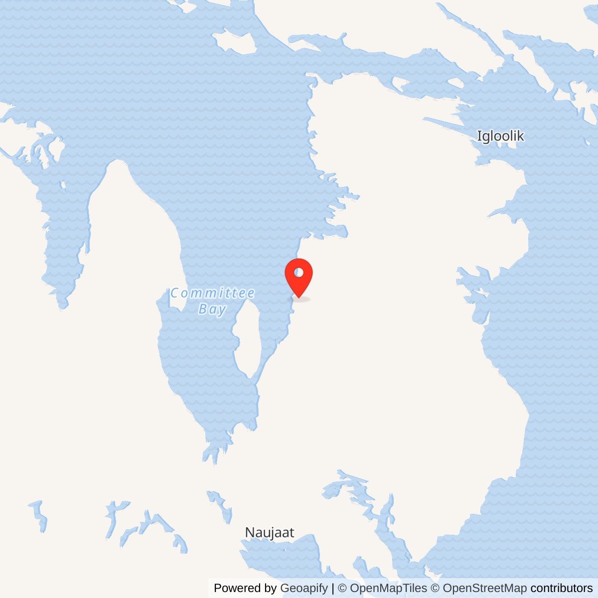
Longitude: -85.6628
Site Number: CAM-5
Current Role: Former DEW Line station and airfield; distinct from later Cape McLoughlin and Lailor River NWS sites.
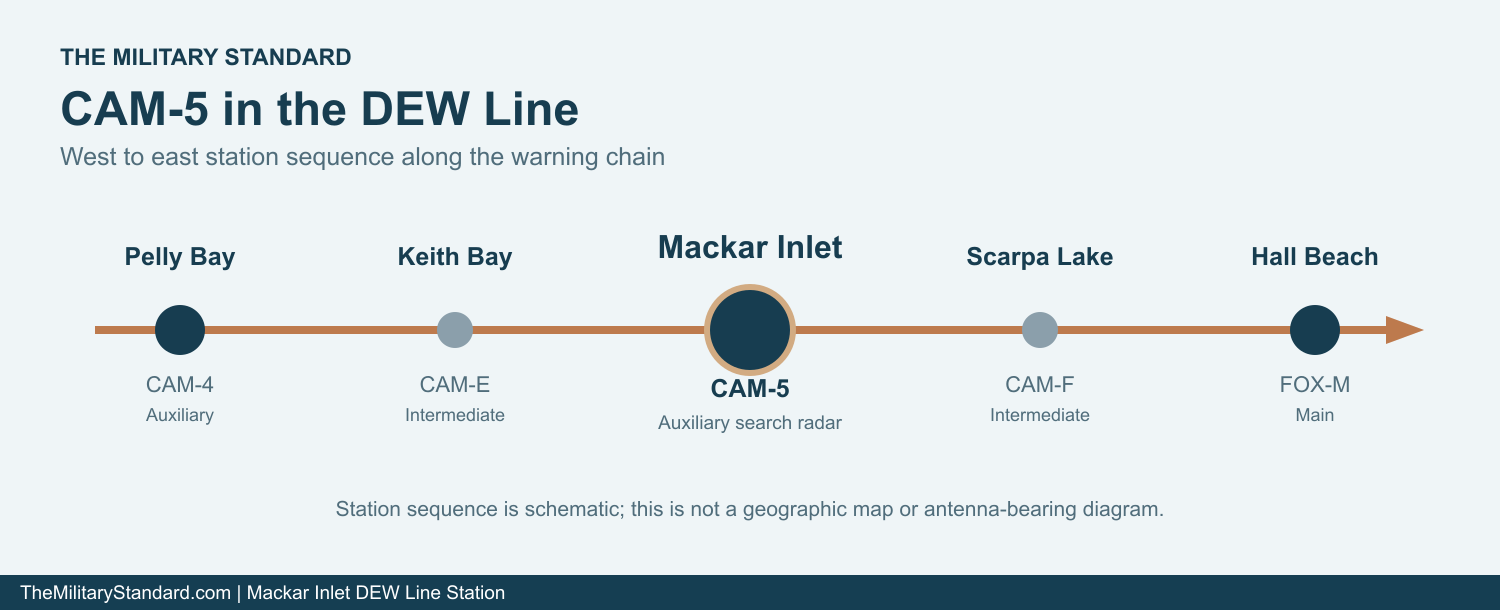
Mackar Inlet CAM-5 was an auxiliary radar station on the western side of the Melville Peninsula in what is now Nunavut. It was one of the staffed search-radar sites of the Distant Early Warning Line, the Arctic warning chain built to detect aircraft approaching North America from the north. The CAM-5 designation placed it east of the Pelly Bay CAM-4 auxiliary station and west of the Hall Beach FOX-M main station. Keith Bay CAM-E and Sarcpa Lake CAM-F were the smaller intermediate posts in the gaps on either side. [1] [2] [8] [11]
- DEW Line code
- CAM-5
- Role
- Auxiliary search-radar station
- Principal radar
- AN/FPS-19
- Operating period
- 1957 to 1992
- Location
- Western Melville Peninsula, Nunavut
A Radar Station Above Mackar Inlet
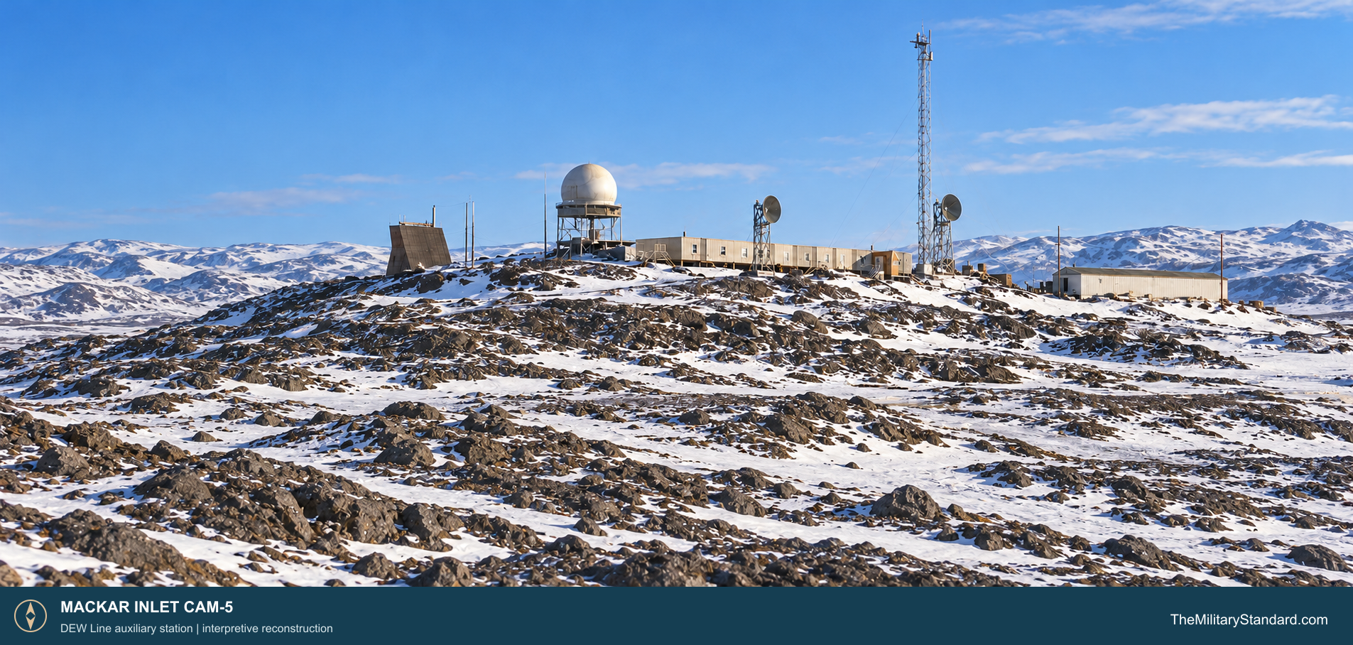
This was a high and unusually divided installation. A contemporary site description placed the building train roughly 1,300 feet above sea level on rugged, glacially scoured ground. The airstrip was about three and a half miles away and roughly 100 feet above sea level. A later Canadian site account also distinguishes an upper station with the radar and living plant from a lower airfield and storage area. The road connecting those elevations was vital to routine operation. [2] [3]
Building the Upper Station and Airfield
Construction began before the line opened. Station photographs show the main road from the airstrip under construction in May 1955. In March 1956 the module train stood on the ridge while its radome was still absent. Other photographs show the road in June 1956, ice on a radome guy wire that October, and a more developed road by March 1957. These views trace the work from access road and shelter to a functioning elevated radar installation. [2] [10]
The rocky site complicated what was already a difficult Arctic construction program. March 1956 photographs show the long module train raised on timber supports above the snowy ground. Radar, communications antennas, generators, fuel storage, living quarters and a warehouse had to be brought to the upper site, while the lower area required a landing strip, air terminal and storage. Materials and people then had to move up the steep road between the two. The original plan marked a 3,500-foot runway at the lower area. [2] [3] [5] [6] [10]
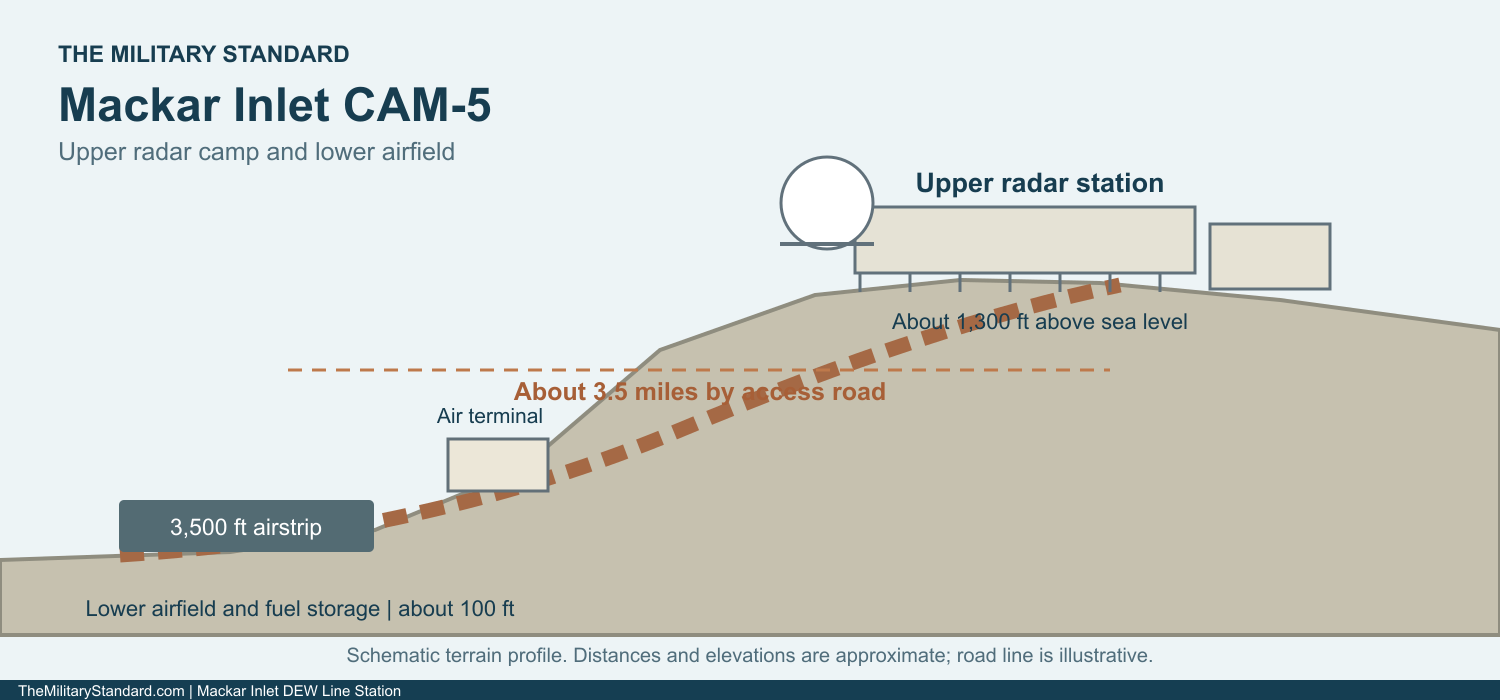
The March 1956 images also show a long, pale module train and a slender communications tower near it. In a separate view, a blue-clad section interrupts the light-colored train. That was a firebreak, a deliberate safety feature in a complex where sleeping rooms, fuel-fed generators and electronics shared one enclosed building. A 1965 station view shows the completed hilltop group with its radome, tall tower and additional antenna structures. [2] [5] [6]
Radar and the Warning Mission
CAM-5 carried the AN/FPS-19 rotating search radar used at the main and auxiliary sites of the original DEW Line. Its two opposed antenna faces swept the northern approaches under a protective radome, while radar operators watched for aircraft returns and passed useful reports through the warning network. An auxiliary station performed its own surveillance and relayed information toward a main station, rather than serving as the sector headquarters. [1] [6] [7]
The low-altitude warning plan also included AN/FPS-23 Fluttar paths between search-radar stations. A 1965 CAM-5 photograph is labeled as a Fluttar tower. Keith Bay CAM-E and Sarcpa Lake CAM-F were intermediate transmitter posts west and east of Mackar Inlet. At an auxiliary station, Doppler receiving equipment could signal a crossing of those paths. The Fluttar alarm did not itself supply the range and bearing track produced by the search radar. [1] [2] [6] [7] [8] [11]
Keeping the warning function useful meant more than leaving a radar turning. Technicians maintained the search set, Doppler receivers, power and timing equipment, voice radios and lateral communications. The auxiliary-station plan placed radar equipment, transmitters, receivers and the surveillance room in adjacent restricted modules. Operators could compare the displayed return with reports from neighboring sites and send an alarm onward while aircraft might still be far to the north. [1] [5] [6] [7]
Communications and the Station Plant
The station had to move reports reliably across distances greater than ordinary line-of-sight radio could cover. Auxiliary stations used UHF tropospheric-scatter communications laterally with other DEW sites and VHF/UHF radio for contact with aircraft. The 1965 Mackar Inlet photographs show separate communications antenna structures near the search-radar radome and a tall tower. Those antennas were part of the station mission, not decoration beside the radar. [2] [5] [7]
A typical auxiliary station combined 25 prefabricated modules into one long, heated train. The standard arrangement provided generators, an electronics workshop, transmitter and receiver rooms, a surveillance room, station offices, receiving and cold-storage rooms, a kitchen, dining area, recreation space, laundry, sanitation and bedrooms. Mackar Inlet photographs show the long train and a cleared area around it. [2] [5] [6]
Outside the train, the upper camp included a warehouse, garage, storage and bulk petroleum facilities. The lower area included the airstrip, air terminal, storage and petroleum facilities. The original site plan places a diesel tank and several storage pads beside the strip and another fuel area nearer the upper buildings. Generators needed stored fuel throughout the winter, and vehicles needed it for the airport road, snow clearing and water haul. [2] [3] [5]
Mackar Inlet presented a special resupply problem. A DEW Line operations account names CAM-5 among the landlocked or ice-locked stations supplied with an annual fuel airlift. Regular lateral aircraft also moved staff, mail, food, spare parts and cargo between the main stations and their auxiliaries. Once a plane landed, every urgent delivery still had to travel several miles uphill to the radar camp. [2] [3] [5]
The People Who Kept CAM-5 Running
The operating crew was chiefly civilian technical and support staff working under the Air Force-run warning program. An Air Defense Command account, summarized by a Corps study, gives approximately 16 to 18 radicians for a typical auxiliary station. A station chief, radar and communications technicians, power and building mechanics, equipment operators and food-service workers together kept the station staffed around the clock. [1] [5] [6] [7]
Daily life took place inside the heated train. Workers moved along an enclosed corridor from bedrooms and dining space to the surveillance room, electronics shop and power modules. Meals, a library or recreation room and movies helped fill off-duty hours, but isolation was severe. Mechanical work and the daily watch could not stop for weather, and snow or ice around the buildings, airstrip and road demanded continual attention. [5] [6] [7]
Water was another regular task. The original CAM-5 description gives a half-mile round-trip haul for potable water in both summer and winter. Maintenance crews also hauled fuel and supplies, repaired vehicles, kept the runway and access road usable, and checked the buildings for heat and fire safety. The 1965 photographs of fuel bladders and the bleak airstrip show how closely radar operations depended on those ordinary services. [2] [5]
From the DEW Line to the North Warning System
The original DEW Line entered service in 1957 and CAM-5 continued through the Cold War, even after the intermediate Fluttar posts shut down in 1963. Keith Bay and Scarpa Lake ceased their original Doppler work, but Mackar Inlet remained a staffed search-radar and communications site. Later equipment and procedures changed across the network while its basic aircraft-warning mission continued. [1] [4] [7] [8]
In 1985 Canada and the United States agreed to modernize the northern warning system. Better-positioned, more automated radars gradually replaced the remaining DEW Line sites. A Canadian project description says Mackar Inlet CAM-5 closed in 1992 during those upgrades. The North Warning System established Cape McLoughlin CAM-5A and Lailor River CAM-FA as distinct later radar locations in the region. [3] [4] [8] [9]
The former Mackar Inlet station then entered a long cleanup and monitoring period. Later federal records still identify its old DEW parcel separately from the Cape McLoughlin North Warning System property. The separate names reflect a physical change as well as a technological one: the new remote radars replaced a staffed, self-contained hilltop station with a different layout and operating model. [3] [4] [8] [9]
Chronology
- May 1955 Construction photographs show the road from the airstrip to the upper station under way. [2]
- March 1956 The upper module train stands on the ridge before installation of the radome. [2]
- October 1956 A site photograph records ice on a radome guy wire during the buildout. [2]
- 1957 The original DEW Line enters service with CAM-5 in its auxiliary search-radar chain. [1] [7] [8]
- 1963 Intermediate Fluttar stations on either side close while CAM-5 continues its search-radar mission. [1] [7] [8]
- 1985 Canada and the United States agree to modernize the northern aircraft-warning system. [3]
- 1992 CAM-5 closes during North Warning System upgrades. [4]
Related Sites
- DEW Line station directory
- DEW Line history
- AN/FPS-19 search radar
- AN/FPS-23 Fluttar
- Pelly Bay CAM-4
- Keith Bay CAM-E
- Sarcpa Lake CAM-F
- Hall Beach FOX-M
- Cape McLoughlin CAM-5A
- Lailor River CAM-FA
Information sources (11)
- PDFU.S. Air Defense Command, A History of the DEW Line, 1946-1964, Historical Study No. 31
Contemporary account of the original DEW Line mission, construction, search radar, Doppler fence, communications and contractor operations.
- WEBThe DEWLine, Mackar Inlet CAM-5 station history and photographs
Station-specific 1955 to 1957 construction sequence, 1965 views, upper-station elevation, airstrip separation, water haul and terrain.
- PDFNunavut Water Board, Clean Up of CAM-5, Mackar Inlet DEW Line Site, executive summary, 2005
Identifies the separate upper and lower facilities, roads and airstrip, and the 1985 North American air-defense modernization decision.
- PDFNunavut Water Board, CAM-5 Mackar Inlet non-technical project description, 2002
Directly dates closure of the original CAM-5 station to 1992 during North Warning System upgrades.
- WEBDEWLine Museum, Operations
Period description of auxiliary stations, module trains, logistics, maintenance duties, air service and annual fuel flights to CAM-5.
- WEBThe DEWLine, Auxiliary and Intermediate Site Layouts
Firsthand description of the typical 25-module auxiliary building train, technical rooms, crew facilities and planned staffing.
- WEBU.S. Army Corps of Engineers, Annotated Bibliography: Distant Early Warning System, Alaska, 2008
Summarizes original Air Defense Command evidence for auxiliary radar and communications equipment, typical staffing and DEW Line living conditions.
- PDFGovernment of Canada, The DEW Line: A Bibliography and Documentary Resource List, 2005
Identifies CAM-5 as a DEW auxiliary site and distinguishes Cape McLoughlin CAM-5A and Lailor River CAM-FA as later NWS sites.
- PDFGovernment of Nunavut, Nunavut Lands and Resources Devolution Agreement, 2024, former military sites schedule
Lists the former Mackar Inlet DEW CAM-5 parcel separately from Cape McLoughlin NWS parcels and the Lailor River NWS site.
- PDFDEW Line Coordinating Committee, Minutes and Progress Reports, 1955-63
Contemporary record of the 1955-57 construction and airlift program and the original auxiliary-station airstrip planning standard.
- WEBThe DEWLine, station table
Historic station order between Pelly Bay, Keith Bay, Mackar Inlet, Scarpa Lake and Hall Beach.