
Boswell Bay White Alice Communications Site, Alaska
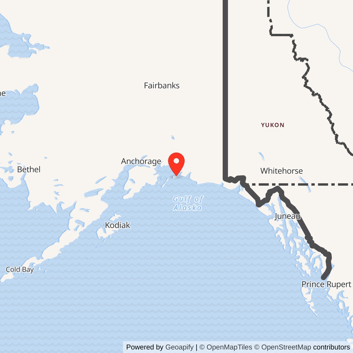
Longitude: -146.154921
Location note: Kenny Cove, Hinchinbrook Island, approximately 18 air miles west of Cordova. A reliable surveyed station point in decimal degrees was not verified.
Identity and setting
Boswell Bay White Alice Communications Site was an independent long-distance radio relay station on Hinchinbrook Island in Prince William Sound, Alaska. The Historic American Engineering Record (HAER) identifies it as Boswell Bay White Alice Site, also called Boswell Bay Alascom Site, and gives its Alaska Heritage Resources Survey identity as 49COR312. It was not an aircraft-warning radar station. Its function was to carry communications between distant stations, including information generated by Alaska's radar and air-defense network. The later commercial operator's name, Alascom, describes a phase of use and does not make the station a second installation.
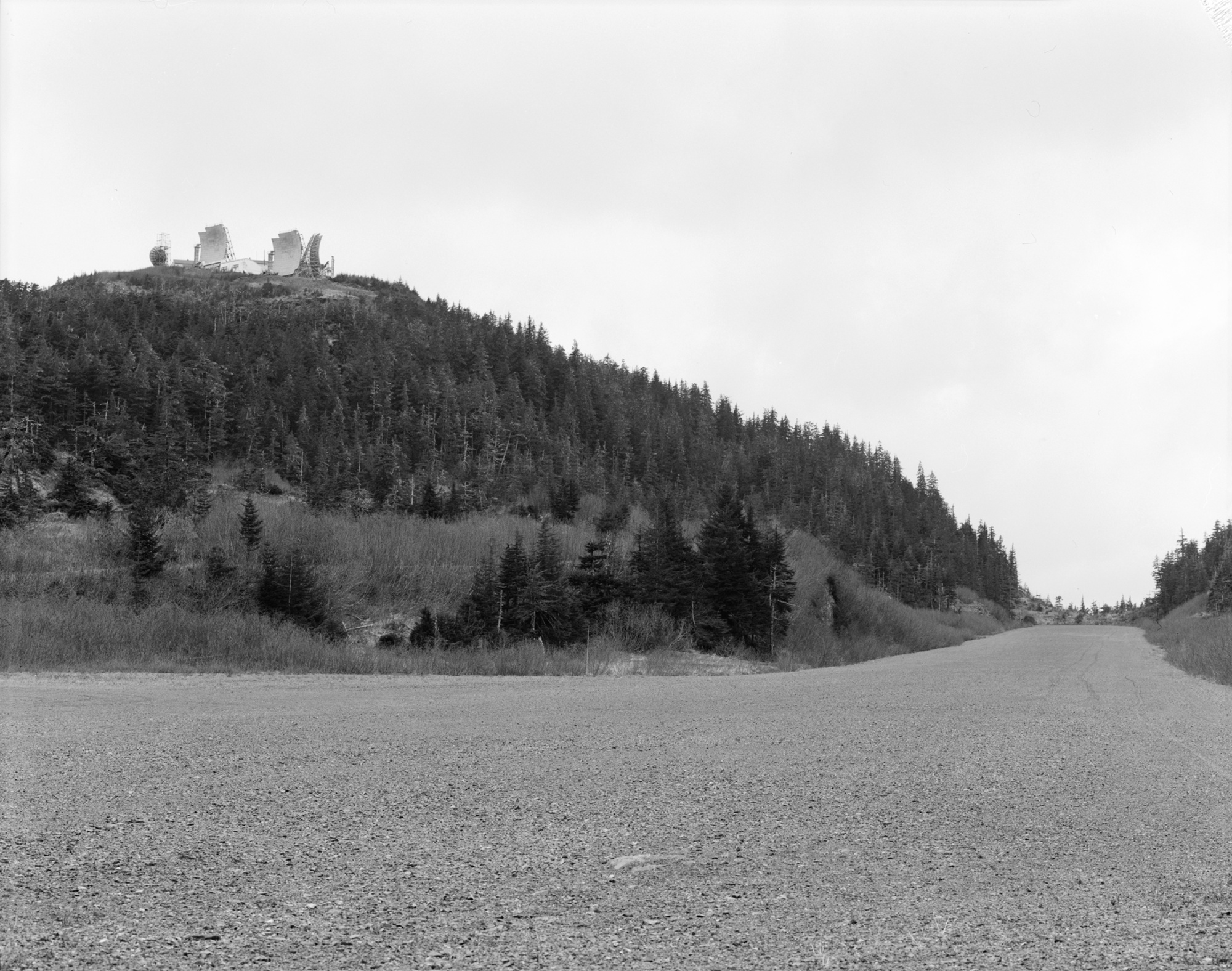
The station stood near Kenny Cove, approximately 18 air miles west of Cordova, in what is now the Chugach Census Area. HAER described five connected physical components: a cleared upper communications summit at about 780 feet above sea level; a residential level at about 600 feet; a beach-level warehouse and fuel-handling area; an airfield; and a gravel road joining them. The upper site was about 1.5 miles from Kenny Cove by the survey's account. Boat and small aircraft access, severe weather, steep terrain and the absence of an ordinary road connection to a town shaped nearly every part of the facility. The site should be understood as a dispersed working installation, not just the famous antenna skyline. [1]
HAER printed a four-point UTM envelope for the historic developed area and a separate land description with parcels and easements. It did not provide a modern surveyed antenna coordinate in decimal degrees, nor a single unambiguous total station acreage. The historical parcel figures and the wider envelope are useful archival evidence, but they do not establish present title or public access. [1]
The legal description helps explain why a single acreage would mislead. HAER transcribed one parcel of about 16.82 acres and another of about 47.75 acres, followed by narrow strips and road interests. Some parts overlap. The sum of the first two parcels would omit the other interests, while a sum of every printed figure could double-count overlaps. The installation history therefore describes the five functional areas and preserves the underlying legal record without manufacturing a property total. The site's historic address was commonly assigned to the Cordova vicinity in the former Valdez-Cordova Census Area; the Library of Congress has updated its catalog display to Chugach Census Area after the 2019 boundary change. This is a jurisdiction-label change, not a move of the station. [1] [8]
Why White Alice reached Boswell Bay
After World War II, Alaska's aircraft-control and warning stations, interceptor bases and later Distant Early Warning (DEW) Line positions needed dependable long-distance communications. A radar report was valuable only if it reached command and interceptor units in time to matter. Earlier high-frequency and very-high-frequency communications could be disrupted by atmospheric conditions, and conventional line-of-sight microwave would have required many more intermediate sites across difficult terrain. Air Force planners accepted a Bell System proposal for a network using high-powered tropospheric scatter on long routes and microwave where line of sight made it economical. Western Electric received the system contract in 1955. [1] [2] [3]
Tropospheric scatter did not simply bounce a signal from a solid atmospheric layer. A transmitter aimed a powerful radio signal toward the lower atmosphere; a small scattered portion traveled beyond the geometric horizon and could be recovered at a distant receiving site. Multiple paths and signal combining improved reliability. The large reflector surfaces and their precisely aimed feedhorns were the visible end of an entire electrical, switching and maintenance system. This was communications infrastructure for air defense, not a radar set searching for targets. [1] [3]
Boswell Bay and Neklasson Lake were among the earliest White Alice links. The U.S. Army Corps of Engineers' historical inventory says Boswell Bay was built in 1955 and 1956 and activated on November 29, 1956. The University of Alaska Anchorage (UAA) finding aid independently says construction began in 1955 and activation came in late 1956. HAER's catalog heading gives 1954 as an initial-construction date, while its building descriptions say most surviving facilities were built in 1957. A later Corps management plan calls the station activated in 1957. These accounts likely reflect planning, initial communications activation, later completion of permanent facilities and retrospective date labels, but the public material reviewed does not prove exactly how each author defined activation. The most specific station-level opening record is November 29, 1956; it should not be mistaken for proof that every building and every later route was ready that day. [1] [2] [4] [5]
Boswell Bay's routes and evolving mission
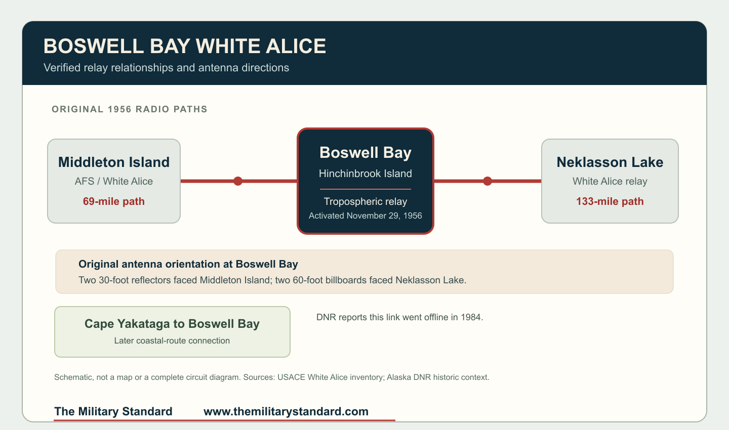
The Corps inventory identifies the original Boswell Bay links as Middleton Island, approximately 69 miles away, and Neklasson Lake, approximately 133 miles away. A pair of roughly 30-foot antennas faced Middleton Island and a pair of 60-foot billboard antennas faced Neklasson Lake. These are radio-path distances and historical design descriptions, not road distances or a basis for guessing the exact position of every reflector. Middleton Island itself had an aircraft-warning station and White Alice equipment; Neklasson Lake was a separate White Alice relay. [4]
The station's value went beyond two local endpoints. White Alice tied the aircraft-control and warning system and DEW Line into larger command, communications and airfield networks. A warning from a remote radar site had to move toward people who could evaluate it and direct fighters. Boswell Bay was one link in that chain, not the place where all those decisions were made. Western Electric's contemporary completion account dates the network's formal Air Force acceptance at Elmendorf Air Force Base to March 26, 1958, after early links such as Boswell Bay were already operating. HAER's later narrative says March 28; the contemporary acceptance account and the Corps' inventory bibliography support March 26. The distinction between site activation and network acceptance matters for the chronology. [1] [4] [9]
As the system expanded, Boswell Bay also figured in the coastal communications route associated with the Ballistic Missile Early Warning System (BMEWS). The Alaska historic context lists it on that coastal route and identifies Cape Yakataga as another important connected station. A station may carry different circuits or functions at different times, so the two original routes should not be treated as the only links ever present. The UAA collection guide lists later link-performance records, circuit orders, cutover material and route-related maintenance documentation. Those files demonstrate a complex operating history but are described in a finding aid, not digitized and read as individual circuit records. They cannot establish an exact year-by-year route diagram by themselves. [2] [3]
That network role also explains why nearby places must not be merged into a Boswell Bay property record. Middleton Island's radar and communications complex generated or forwarded traffic from its own island installation; Neklasson Lake was another relay serving the wider Alaska network; and Cape Yakataga became part of the later coastal chain. Boswell Bay could pass a message among those sites without owning their land, their radar equipment or their command authority. A record of a BMEWS communications circuit at Boswell Bay similarly means the site supported that warning network's long-distance message path, not that it housed a ballistic-missile radar. [2] [3] [4]
Facilities on the summit
The 1987 HAER survey is unusually detailed for a White Alice station. It documented four 60-foot-square billboard reflectors, two smaller concave orange-peel reflectors and four feedhorns. The billboards were assembled from bolted galvanized steel panels on reinforced-concrete foundations. Catwalks and ladders permitted access for inspection and repair; shims helped adjust antenna aim. The orange-peel name described wedge-shaped panels forming the reflecting surface. The survey photographs show why a generic modern satellite dish is a poor substitute for an illustration of this equipment. Their geometry, support framework and feed arrangement were specific to the White Alice era. [1] [6]
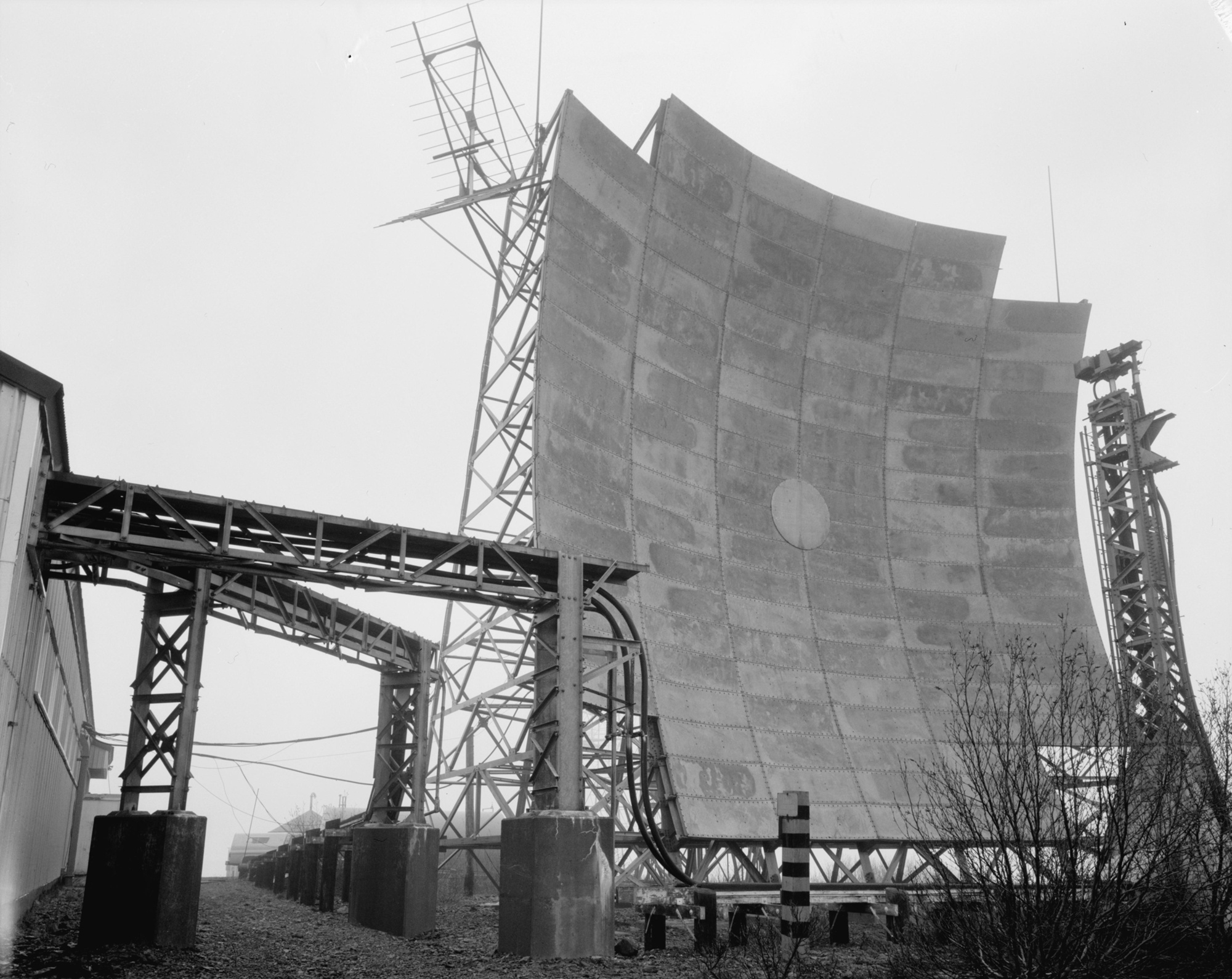
The six-reflector 1987 survey condition is not the same as the inventory's simplified description of the two original working pairs. HAER observed the site after decades of additions and changes. Its feature count records what remained at the time of documentation, while the Corps' 1988 inventory describes the original Middleton and Neklasson paths. The available evidence does not justify assigning a particular service year to each surviving reflector without the as-built drawings or dated modification records. [1] [4]
The upper communication building measured about 36 by 212 feet and, according to HAER, was built in 1957. It contained an entry and gear-removal area, radio equipment room, storage space and powerhouse. A separate radio relay building was joined to it by an enclosed walkway. This separation was a distinctive feature of the early Boswell Bay installation. Equipment bays formed aisles around a central corridor; the operator's handsets and switching gear occupied its front area. Klystron amplifiers, later removed, once supplied radio-frequency power. Battery banks provided electrical support. HAER saw clipboards, spare parts and equipment still in place in 1987, but it also recorded removed fuses and tubes. That survey-era state must not be presented as a fully operational control room. [1]
The rooms show how technicians worked within the climate and radio-frequency constraints. HAER described a central Arctic-style entry passage where personnel could remove wet or winter gear before entering the equipment rooms. In the ante-room, a small test cubicle was screened with copper to shield electronic work from interference. The radio room's equipment bays were supported by a suspended grid, with a manager's office off one corner. Those details are more than architectural curiosities: a site handling weak received signals and high-power transmission needed orderly testing, protected equipment spaces and access to spare parts. The enclosed passage to the separate relay building let staff move between critical rooms without going outside into storm conditions. The survey provides a floor arrangement, but this history does not present a precise visitor floor plan without the original drawing. [1]
Power was a mission-critical system because there was no dependable municipal electrical grid at the hilltop. HAER documented five 150-kilowatt Chicago Pneumatic diesel generators in the powerhouse and a carbon-dioxide fire-suppression system. Their observed inventory is not proof that all five ran simultaneously or were present on the first day of operation. The study reported that after one tropospheric system closed in 1971, one generator normally operated and a second remained in reserve while the others were mothballed. This was an account of changed power demand, not a reliable station-wide closure date. A steel radio tower about 70 feet high also supported shorter-range line-of-sight communications in the immediate area. Nearby were a fire-control building and a 38,000-gallon water tank. [1]
HAER described the building's low profile, window scarcity and robust construction as responses to snow loads and winds that could reach 140 miles per hour. The upper site was created by removing part of the hilltop to obtain enough level ground for the antenna field and buildings. Civil engineering, the fuel pipeline, reliable generators and routine maintenance were as important to the relay's success as the high-power transmitters. [1]
Living, supply and air access
At the lower residential level, a 36-by-141-foot dormitory contained nine two-person bedrooms, a kitchen, food storage, a dining and recreation room, a library and shared washing facilities. Adjacent transient quarters measured about 16 by 54 feet and had three bedrooms. HAER's description of crews remaining for ten-month tours conveys the human cost of maintaining a remote relay, but the source does not name a permanent site-level Air Force squadron or supply a year-by-year staffing roster. Personnel could include government, contractor and later commercial-operator workers across the site's life. It would be misleading to assign every building or person to a single unit without roster or contract records. [1] [2]
The beach level handled a year's supply of fuel delivered by barge. A pumphouse moved diesel from a roughly 126,000-gallon tank near shore uphill to other storage and the generators. The warehouse measured approximately 40 by 78 feet and included vehicle space; two 22-kilowatt Detroit diesel generators served the beach buildings. The original boathouse was already in poor condition when HAER inspected it. A garage-shop had burned in 1984. These details show the station as a working supply chain, not just a hilltop transmitter. Failure of the landing, pumps or road could become a communications problem even when the radio equipment itself was serviceable. [1]
This arrangement divided the hazards and work of the installation across the slope. Large-volume fuel delivery occurred at the water; living quarters sat partway uphill; the radio plant occupied the exposed summit. The road joined all three, and the fuel-transfer system linked the beach tanks to machinery at higher levels. At the summit, a dedicated water tank and fire-control building addressed an emergency that outside responders could not quickly reach. HAER's 1987 inventory even recorded a caretaker residence and several ruined or noncontributing beach structures separately from the historically significant communications buildings. Its five-component description therefore should not be flattened into a claim that every structure was original, equally important or still standing after demolition. [1]
The later airstrip was approximately 3,000 feet long and dated by HAER to about 1968. Its survey noted a deteriorated earlier beach or fill landing area and a wood-frame airfield office and hangar at the later strip. The maintained gravel road from beach to communications level was about 1.11 miles, with approximately 1.4 acres of parking and driveway surface. The airfield was part of supporting the relay's isolation, not evidence that Boswell Bay became a fighter base. Current airport status and access require separate aviation and land-manager verification. [1]
Operation, transfer and technological change
The UAA archive finding aid covers Boswell Bay records from 1955 through 1985. It lists station radio logs beginning in 1956, performance assessments, circuit orders, maintenance files, equipment records, restoration plans and extensive drawings. Its inventory includes a 1957 operation and maintenance manual and later file titles for a White Alice exciter, receiver, one-kilowatt klystron amplifier and modification kits for AN/FRC-39A(V). A folder title is evidence that documentation existed at the station, not conclusive proof of the exact installed model, modification date or operational performance of every cabinet. Those questions belong to a deeper examination of the original records. [2]
The depth of that archive is unusual. UAA describes more than 54 cubic feet of records and lists complete series for radio logs, link-performance assessments, site maintenance, drawings, specifications and manuals. It identifies 1956 relay-verification and test-data folders, later cutover procedures, and 1973-1974 records for several numbered links. Those headings show opportunities for a finer operational chronology: when individual routes were accepted, how they performed, what was modified and why operators changed their procedures. Yet a finding aid is an inventory of boxes, not the contents of the boxes. [2]
White Alice also underwent an ownership and operating transition. The HAER narrative describes the broader Air Force to RCA Alaska/Alascom arrangements that accompanied Alaska telecommunications privatization. UAA's finding aid says RCA Alaska Communications acquired the system in 1970, while HAER distinguishes the separate Alaska Communications System transfer in January 1971 and later White Alice leasing and sale arrangements. The dates concern different legal instruments and sometimes different systems. Boswell Bay's archives were eventually transferred by Alascom to UAA in 1987 under a memorandum involving Alascom, the Forest Service, Alaska preservation officials and the federal preservation process. The site's distinctive records thus survived even though its structures did not. [1] [2]
The closure chronology is not reducible to one unqualified date. HAER reports that a Boswell Bay tropospheric communication system closed in 1971 and describes reduced generator use afterward. The UAA finding aid nevertheless lists station logs into 1978, link and maintenance files afterward, and collection material through 1985. Alaska's DNR history states that the Cape Yakataga to Boswell Bay tropospheric connection went offline in 1984. Those facts can coexist if they describe different routes, equipment phases, operating organizations or the difference between station presence and a particular active circuit. The publicly accessible sources located do not provide a signed final station-wide shutdown order, and this history does not claim that 1971, 1984 or 1985 is definitively that day. [1] [2] [3]
Historic documentation, demolition and present condition
In 1987 Boswell Bay was exceptional because the abandoned equipment and buildings remained comparatively intact. HAER recorded the individual antennas, equipment rooms, dormitory, warehouse, access system and numerous secondary features before demolition. Its photographs are therefore a record of the site shortly before removal, not images of surviving structures today. The historic-site designation 49COR312 and the national record of photographs and measured descriptions preserve evidence that could otherwise have been lost. The federal register of properties determined eligible for the National Register identifies Boswell Bay White Alice Site with an eligibility date of June 26, 1987. Eligibility is not the same as an independently verified individual listing. [1] [7]
That preservation effort was not confined to a photograph of an antenna. HAER's feature index distinguished contributing communications buildings and structures from ruined, later or otherwise noncontributing items at the beach and airfield. It recorded the functions of the powerhouse, fire-control room, residential buildings and fuel system while those features could still be inspected. The survey also reproduced a legal description that can be compared with original land files. These records permit a future reconstruction of how the installation worked as a whole, while making clear that no diagram in this package is a surveyed replacement for the archival site plan. The federal determination recognized the site's historic importance even though the physical structures were then removed. UAA's receipt of the station's operating archive provides a second source stream for researchers seeking circuit histories and construction changes beyond the 1987 snapshot. [1] [2] [7]
Alaska's statewide historic study states that Boswell Bay was demolished in 1987 after extensive documentation. The Corps' 1994 management plan likewise says the station had been demolished and its site environmentally restored. Its phrase is a broad historical condition statement, not a current parcel-by-parcel environmental closure certificate. HAER noted removal of some PCB- and asbestos-bearing materials during the 1987 documentation period. The UAA collection includes a site-restoration-plan file, but the finding aid alone does not establish the executed work, contaminant levels or legal closure of each area. Current land title, remaining foundations, access rights and environmental restrictions need a contemporary land-manager or environmental record before they can be described more precisely. [1] [2] [3] [5]
Historical significance and research limits
Boswell Bay illustrates how Alaska's air-defense system depended on communications stations that never housed a search radar or fighter squadron. It was among the first White Alice links, connected Middleton Island and Neklasson Lake, participated in later coastal network development, and remained important enough to receive one of the most thorough pre-demolition engineering surveys of a White Alice station. Its unusual separate radio relay building, six documented reflectors, island logistics and surviving archive make it especially useful for understanding the network as a set of working places rather than a line on a map. [1] [2] [3] [4]
The history has deliberate limits. It does not turn HAER's broad 1954 catalog field into a precise operational opening; substitute the 1994 plan's 1957 activation without noting the Corps' specific 1956 date; assume every reflector in the 1987 photographs served every circuit from the beginning; or convert an archive folder title into proof of installed equipment. It does not treat a survey-year observation, environmental-restoration phrase or public map point as proof of present condition. The strongest next research step is examination of UAA's original station logs, as-built drawings, circuit orders and restoration file, followed by current Forest Service, land-title and environmental records.
Chronology
- 1954 The Alaska Communication Study Group reports on the need for a more dependable network; HAER's catalog later applies 1954 as a broad initial-construction label for Boswell Bay, not a verified activation date.
- 1955 Western Electric receives the White Alice system contract and construction begins at Boswell Bay according to UAA and the Corps.
- 1956-11-29 The Corps' historical inventory records Boswell Bay activation; UAA independently places activation in late 1956.
- 1957 HAER dates most of the documented permanent buildings to this year; a later Corps plan uses 1957 as its activation year.
- 1958-03-26 Western Electric's contemporary account dates the White Alice network's formal Air Force acceptance at Elmendorf Air Force Base; HAER's later narrative gives March 28.
- About 1968 The roughly 3,000-foot Boswell Bay airfield is constructed, according to HAER.
- 1970-1971 RCA Alaska/Alascom and federal authorities undertake communications-system transfers and leasing; different sources refer to different systems and legal steps.
- 1971 HAER reports a Boswell Bay tropospheric system closed and documents subsequent reduced generator use; this does not prove the whole station closed.
- 1976 UAA's finding aid includes Boswell Bay station logs through this year and lists additional 1978 logs.
- 1984 Alaska DNR's historic study places shutdown of the Cape Yakataga-Boswell Bay tropospheric link in this year; Boswell Bay's garage-shop also burned in 1984.
- 1987-05 to 1987-06 HAER surveys and photographs the station before demolition; the federal eligible-property record dates Boswell Bay's National Register eligibility determination to June 26.
- 1987 Boswell Bay's White Alice structures are demolished after documentation, according to DNR and the Corps' later management plan; Alascom transfers its large station-record collection to UAA.
- 1994 The Corps describes the demolished site as environmentally restored, without supplying a modern parcel-specific closure determination.

Information sources (9)
- PDFHistoric American Engineering Record, Boswell Bay White Alice Site, HAER AK-21, 1987
Source for: site identity, 1987 physical survey, facilities, people, access, equipment, preservation context and conflicting closure wording.
- WEBGuide to the Alascom White Alice Communications System Boswell Bay Station Records, HMC-0001, University of Alaska Anchorage
Source for: station construction and late-1956 activation, operating-record span, equipment-document titles and archival transfer.
- PDFThe Coldest Front: Cold War Military Properties in Alaska, Alaska Department of Natural Resources
Source for: White Alice technical and network context, Boswell Bay's coastal route, 1984 Cape Yakataga link closure and 1987 demolition.
- PDFHistorical Overview and Inventory: White Alice Communication System, U.S. Army Corps of Engineers, 1988
Source for: November 29, 1956 activation, Middleton and Neklasson path distances and reflector sizes, original station facilities, demolition and preservation documentation.
- PDFThe Cold War in Alaska: A Management Plan for Cultural Resources, U.S. Army Corps of Engineers, 1994
Source for: later 1957 activation wording, demolition, broad environmental-restoration statement and historical-record disposition.
- WEBBoswell Bay White Alice Site, Tropospheric Antennas, HAER AK-21-A, Library of Congress
Source for: authenticated 1987 antenna photographs and reflector appearance; photographer Rob Stapleton.
- PDFFederal Register, Properties Determined Eligible for the National Register in Fiscal Year 1987, May 24, 1988
Source for: Boswell Bay Site 49COR312 eligibility determination dated June 26, 1987.
- WEBBoswell Bay White Alice Site, HAER AK-21, Library of Congress collection record
Source for: station photograph, catalog identity, historic-resource number and current census-area label.
- PDFThe White Alice Network, Western Electric Company, 1958
Source for: contemporary account of formal Air Force acceptance on March 26, 1958; used to reconcile a later conflicting HAER date.