
Neklasson Lake White Alice Communications Site, Alaska
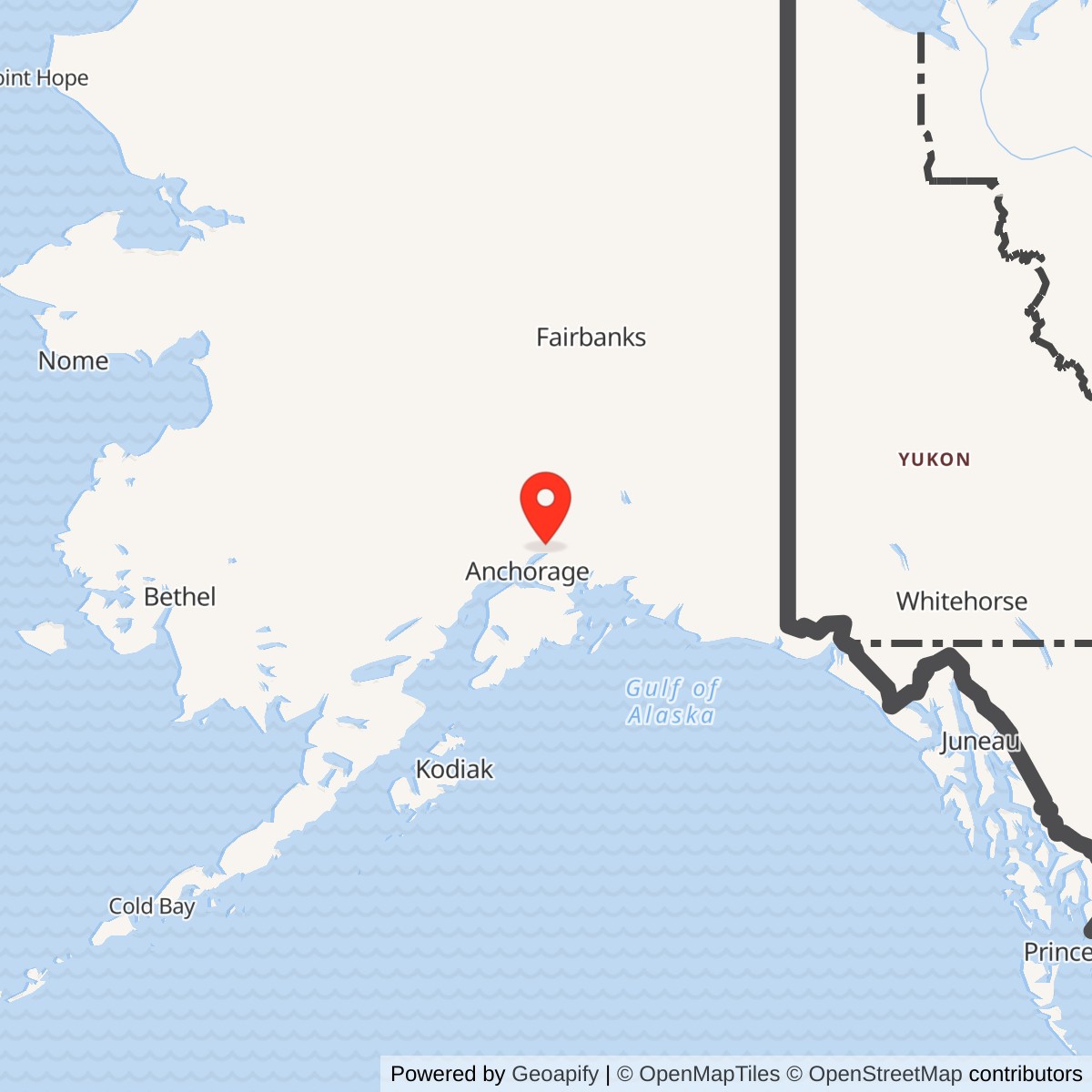
Longitude: -149.256389
Coordinate note: 61.620000 N, 149.256389 W is Alaska DEC's NAD83 environmental-site point. It is not a surveyed antenna location, historic property centroid, or boundary.
- Mission
- White Alice tropospheric scatter, TD-2 microwave relay, and later military telephone switching.
- First operational date
- November 29, 1956, jointly with Boswell Bay in the Corps historical inventory.
- Direct radio links
- Boswell Bay by troposcatter; Elmendorf R1-N by TD-2 microwave.
- Later switching
- Western Electric 4A ATSS switch installed in 1962; Neklasson also had a staffed 5D switchboard.
- Later condition
- Active Alascom facility in 1988 and 1994 records; present communications traffic and surviving original antennas unverified.
Identity and location
Neklasson Lake was a distinct White Alice Communications System station near Palmer and Wasilla in the Matanuska-Susitna Borough. It was not a radar station, an annex of Elmendorf Air Force Base, or a satellite earth terminal when the original military network opened. The original installation combined a long-distance tropospheric-scatter path with a TD-2 line-of-sight microwave path. The U.S. Army Corps of Engineers classified it among the three original mixed troposcatter and microwave stations, a category that helps explain why this comparatively accessible station became a switching point instead of merely forwarding one signal. The Alaska Heritage Resources Survey identifier reported in the 1994 Corps plan is ANC-649. Alaska DEC describes a later 14.42-acre communications property about three-quarters of a mile south of Neklason Lake. Its published 61.620000 N, 149.256389 W NAD83 point was derived from environmental investigation maps, not a surveyed antenna base, parcel centroid, or property boundary. [1] [2] [4]
Origins and the first operating link
White Alice was built to replace fragile, low-capacity long-distance communications across Alaska and to carry warning and command traffic among aircraft-control-and-warning stations, interceptor bases, and higher headquarters. The Corps' historical inventory identifies Neklasson Lake and Boswell Bay as the first two White Alice stations to become operational on November 29, 1956. This is a station and link milestone, not proof that every later switching circuit or permanent structure was complete that day. Planning and path testing predated the opening. A design-and-test table preserved in the Air Force's later sale study places Neklasson Lake in the 1955 original engineering program, although several figures in the scanned table are not reliably legible enough to use as exact acceptance dates. The opening gave the Anchorage region a working connection to a remote coastal relay while the remainder of the original network was still being built. [1] [3]
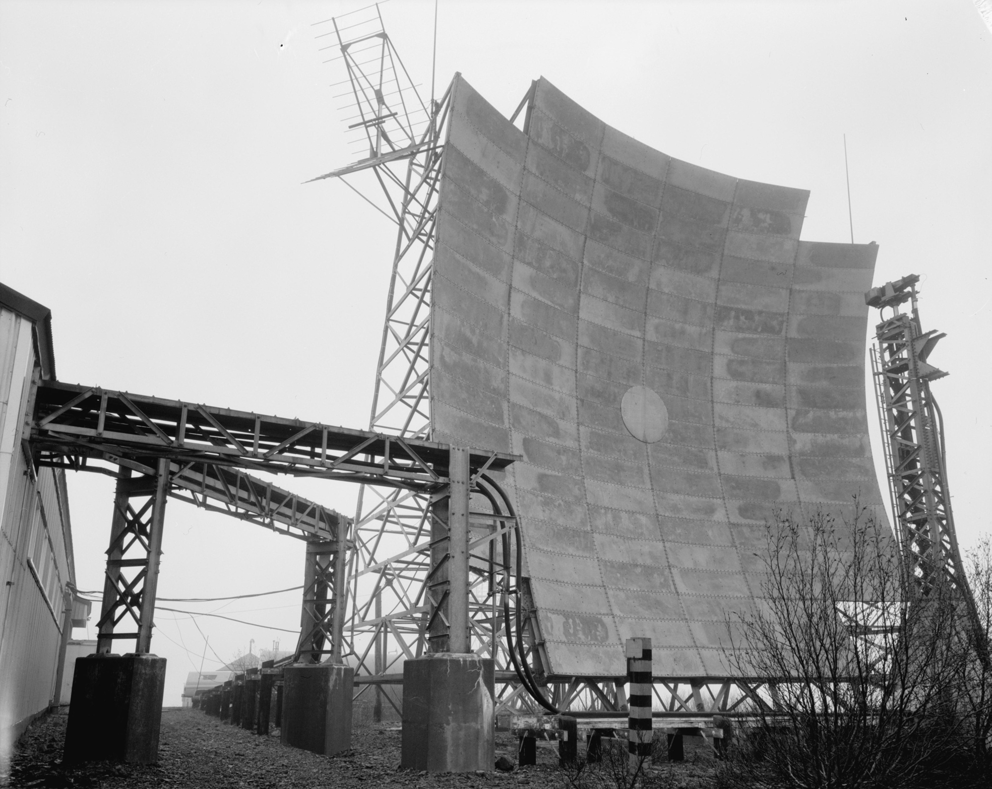
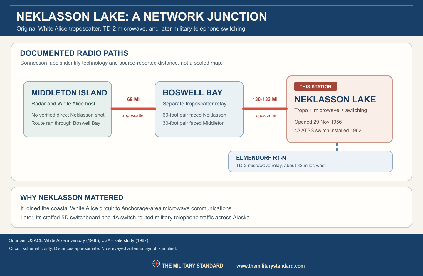
The core long-distance path ran from Neklasson Lake to Boswell Bay on Hinchinbrook Island, approximately 130 to 133 miles away in different Corps summaries. Boswell Bay then connected to Middleton Island, roughly 69 miles farther south. The 1988 inventory explicitly describes Boswell Bay as the intermediate station and assigns its larger 60-foot billboard antenna pair to the Neklasson path. That network geometry matters because a separate Middleton paragraph compresses the route into language that could be read as a direct Middleton-to-Neklasson hop. The Boswell and Neklasson station descriptions and the earlier network diagram support the two-hop route. The first telephone call reported through Middleton Island therefore reached the mainland through Boswell Bay, rather than by a confirmed direct Middleton-to-Neklasson shot. [1] [3]
The microwave and switching mission
Neklasson Lake also had a TD-2 microwave connection westward to the unattended Anchorage R1-N relay on Elmendorf Air Force Base. The Corps placed R1-N about 32 miles away and described its onward connections to Rabbit Creek and the Anchorage communications toll center. These were line-of-sight microwave segments, technologically different from the beyond-horizon Boswell Bay troposcatter path. A relay at Neklasson could thus bridge two kinds of radio circuit and route traffic into the Anchorage switching complex. No search radar, aircraft-warning squadron, or fighter unit is documented at Neklasson Lake itself. [1] [2]
The station's role expanded after the first links opened. The Corps says Project Stretchout brought switching capability and incorporated Neklasson Lake into the Ballistic Missile Early Warning System A Route, a communications path rather than a ballistic-missile radar at this location. It further lists Neklasson with Big Mountain, Kalakaket Creek, and Pedro Dome as four diversified Alaska Telephone Switching Station nodes. The Air Force communications sale study is more specific: Western Electric 4A crossbar toll switches were installed at these four locations in 1962 to provide direct-distance dialing among military installations and connections toward the continental AUTOVON network. Operators handled calls from a 5D switchboard at Neklasson Lake; the other three switch sites were not staffed with equivalent operators in the account. This makes Neklasson a human-operated switching center within a distributed military telephone network, not simply an antenna field. [1] [3]
The 1970s transition shows how the site adapted when satellites began replacing terrestrial radio. The Air Force study records successful July 30, 1976 tests at Neklasson Lake of Proctor 929 satellite guard units and says twenty were installed by the end of that year, though a separate echo issue remained unresolved. During the 1977 reconfiguration, Kalakaket Creek switching equipment was scheduled for transfer to Neklasson and Pedro Dome. The study includes both a planning schedule for late 1977 and a later statement that Kalakaket's switch was deactivated on July 19, 1977; those are different documentary stages and should not be flattened into a single uncomplicated transfer date. On May 18, 1977, government and RCA Alascom representatives agreed that eight existing Shemya ATSS trunks would terminate at Neklasson after Adak's satellite terminal was activated. The record also contemplated seven additional trunks using transferred dial-pulse equipment. It does not establish that all planned work occurred on the dates initially proposed. [3]
The documentary record is stronger for the station's network assignment than for an individual garrison roster. The original facility belonged to the Alaskan Air Command White Alice system. The 1977 trunk-routing agreement involved the Defense Communications Agency, Air Force Communications Service, the 1931st Communications Group, and RCA Alascom, showing that switching changes required both military and civilian coordination. These organizational participants are documented for network planning, not as proof that all maintained personnel at Neklasson Lake. No permanent Neklasson-specific Air Force squadron designation has been verified. [1] [3]
Facilities and daily work
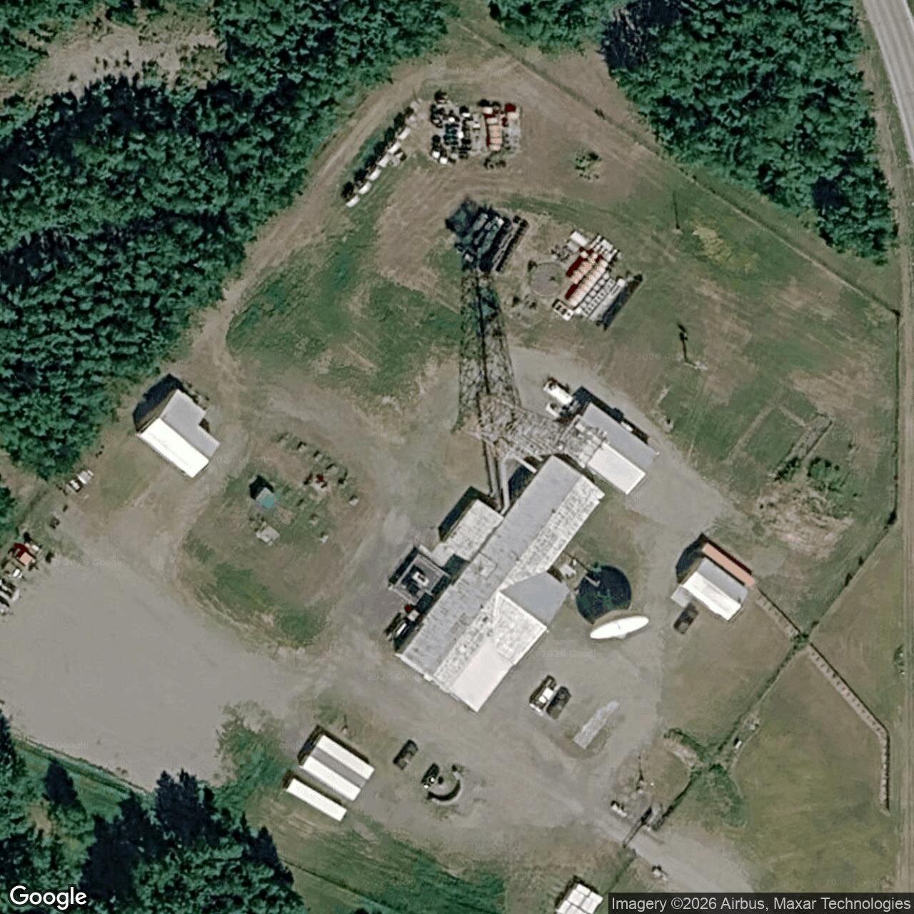
The 1988 Corps inventory describes a 5,710-square-foot equipment and power building assembled in seven sections. It lists a communications center, power-plant room, switchboard room, pump station, radio room, microwave equipment room, and office-control room. This room-by-room description fits the site's combined relay and switching mission: reliable electric generation kept the high-power and line-of-sight radios operating, while the switchboard and control spaces routed telephone traffic. The same inventory records a paint shed and 250-gallon petroleum storage tank. It says the original equipment had mostly been removed by the survey date, except for a backup generator, while the unused 60-foot troposcatter reflectors still stood. This is a late-1980s observation, not a statement about what survives today. [1]
The 1994 Corps management plan calls Neklasson's main building a concrete-block design and says it did not have an original dormitory or garage under that standard plan. This distinguishes it from the wood-frame operations buildings and dormitories at many remote stations. Alaska DEC later calls one building a garage where transformers had been stored during White Alice operation. The sources may use different building labels or describe an addition, but they do not establish the construction date of that garage. It would be inaccurate to erase DEC's observed building or to retrofit it into the 1956 standard design. The 1988 inventory calls the station readily accessible from Anchorage near Palmer, helping explain the absence of an original on-site dormitory and the later civilian reuse, but it does not document every staffing pattern or commuting arrangement. [1] [2] [4]
Role in the Wider Military Network
Neklasson Lake joined the Gulf of Alaska coastal circuit to Anchorage-area command communications. To the south, the confirmed Boswell Bay path carried Middleton Island traffic onward to the mainland. To the west, the R1-N microwave path tied the station into Elmendorf and the Anchorage toll center. Later, the A Route and ATSS placed Neklasson in a redundant web of telephone and warning circuits with Big Mountain, Kalakaket Creek, and Pedro Dome. A failure at one switching node could be routed around through the others according to the Corps' system description. The site therefore mattered both to local aircraft-warning communications and to the continuity of longer military voice circuits. Those relationships must not be mistaken for common ownership of all the neighboring properties or for a radar mission at Neklasson itself. [1] [3]
Civilian transition, environment, and present evidence
The Air Force's sale study records a July 1, 1976 lease under which RCA Alascom assumed long-line service obligations while military traffic continued to use the system. This was a network transition, not proof of the exact date on which the Neklasson parcel deed changed hands. A later military-engineering account says the Boswell Bay-to-Neklasson troposcatter link was the last White Alice link and continued to serve Middleton Island until January 1985. The precise final local transmitter shutdown day remains unverified. The 1988 Corps survey found original equipment removed but two 60-foot antennas still standing and characterized the site as in use by Alascom. The 1994 Corps plan again called it an active Alascom facility in good condition. Those dated observations do not prove that the old troposcatter hardware was still working in 1994 or that its antennas remain today. [1] [2] [3] [7]
Environmental records clarify part of the later property history without providing a complete ownership chain. Alaska DEC identifies the former station as AT&T Alascom Neklason Lake Relay, hazard ID 121. It describes a 14.42-acre property, an October 1983 PCB corrective action near transformer storage, removal in 1991 of two former USAF diesel underground tanks of 10,000 and 3,000 gallons, a 1998 PCB corrective action, and cleanup approval on June 27, 2005. DEC states that remaining known contamination was below its cleanup levels at that decision and lists no institutional controls for this case. That status applies to the specific DEC case, not automatically to every historic parcel feature or to another facility record at the site. A separate 2026 DEC financial-responsibility listing names an AT&T Neklasson Lake Earth Station. It supports continuing AT&T-associated facility administration and fuel-tank compliance, but by itself does not verify current radio circuits, the identity of every structure, or public access. [4] [5]
August 1958 Bell Laboratories Record identifies a contemporary photograph of 60-foot beyond-horizon antennas at Neklasson Lake. The Anchorage Museum's Bill Ray White Alice finding aid lists a November 1956 photograph of the station's 60-foot antenna support during erection. These sources establish that site-specific construction and operating-era images exist. [6] [8] [9]
Chronology
- 1955 Neklasson Lake entered the original White Alice engineering and path-testing program; exact acceptance days in the scanned table are not relied upon.
- 1956-11-29 Neklasson Lake and Boswell Bay became the first operational White Alice stations according to the Corps inventory.
- 1958-08 Bell Laboratories Record published a site-specific photograph of the 60-foot beyond-horizon antennas.
- 1962 Four Western Electric 4A ATSS switches, including one at Neklasson Lake, were installed according to the Air Force sale study.
- 1976-07-01 RCA Alascom's White Alice network lease began; this does not establish the Neklasson land-transfer date.
- 1976-07-30 Satellite guard-unit tests at Neklasson Lake succeeded according to the Air Force study.
- 1977-05-18 Government and RCA Alascom representatives agreed on routing existing Shemya ATSS trunks to Neklasson during satellite cutover.
- 1977-07-19 The Air Force study's later account says Kalakaket Creek's switch was deactivated as the ATSS network was reconfigured.
- 1983-10 PCB corrective action was performed at the later AT&T relay property according to DEC.
- 1985-01 A later military-engineering history reports the final Boswell Bay-to-Neklasson White Alice link ended; exact local shutdown day not independently verified.
- 1988 The Corps found original equipment largely gone, a backup generator remaining, and unused 60-foot reflectors standing at an Alascom-used station.
- 1991 Former USAF 10,000- and 3,000-gallon underground diesel tanks were removed, according to DEC.
- 1994 The Corps management plan described an active Alascom site, 5,710-square-foot building, and AHRS identifier ANC-649.
- 1998-12 PCB corrective action was completed for the DEC case.
- 2005-06-27 Alaska DEC approved cleanup completion for hazard ID 121.
- 2026 Alaska DEC listed an AT&T Neklasson Lake Earth Station fuel facility; exact current communications activity remains unverified.
Information sources (9)
- PDFU.S. Army Corps of Engineers, Historical Overview and Inventory: White Alice Communication System, 1988
Source for: original network roster, first opening, Boswell Bay and R1-N links, building rooms and 1988 condition.
- PDFU.S. Army Corps of Engineers, The Cold War in Alaska: A Management Plan for Cultural Resources, 1994
Source for: concrete-block building, no original standard-plan dormitory or garage, 1994 Alascom use, and AHRS ANC-649.
- PDFU.S. Air Force, A Special Study of the Sale of the White Alice Communications System, 1987
Source for: ATSS 4A switches, 5D operations, 1976 lease and satellite interface, 1977 Shemya and Kalakaket reconfiguration.
- WEBAlaska Department of Environmental Conservation, AT&T Alascom Neklason Lake Relay, hazard ID 121
Source for: 14.42-acre later property, NAD83 environmental point, fuel tanks, PCB history and 2005 cleanup completion.
- WEBAlaska Department of Environmental Conservation, UST Facilities With Proof of Financial Responsibility
Source for: 2026 AT&T Neklasson Lake Earth Station listing, not verified current radio operations.
- PDFBell Laboratories Record, August 1958, White Alice article
Source for: contemporary Neklasson Lake 60-foot antenna photograph and technical context; image reuse rights not established here.
- PDFSociety of American Military Engineers, Anchorage Post Centennial history, 2020
Source for: later account of January 1985 final Boswell Bay-to-Neklasson troposcatter link; exact station-level shutdown remains qualified.
- PDFAnchorage Museum, Bill Ray White Alice collection finding aid
Source for: archival November 1956 Neklasson antenna-erection photograph and related site-specific photo holdings; image reuse rights not established here.
- WEBLibrary of Congress, HAER AK-21-A, Boswell Bay White Alice Site Tropospheric Antennas
Source for: government-documented photograph of the linked Boswell Bay station used only as a clearly labeled neighboring-site visual reference.