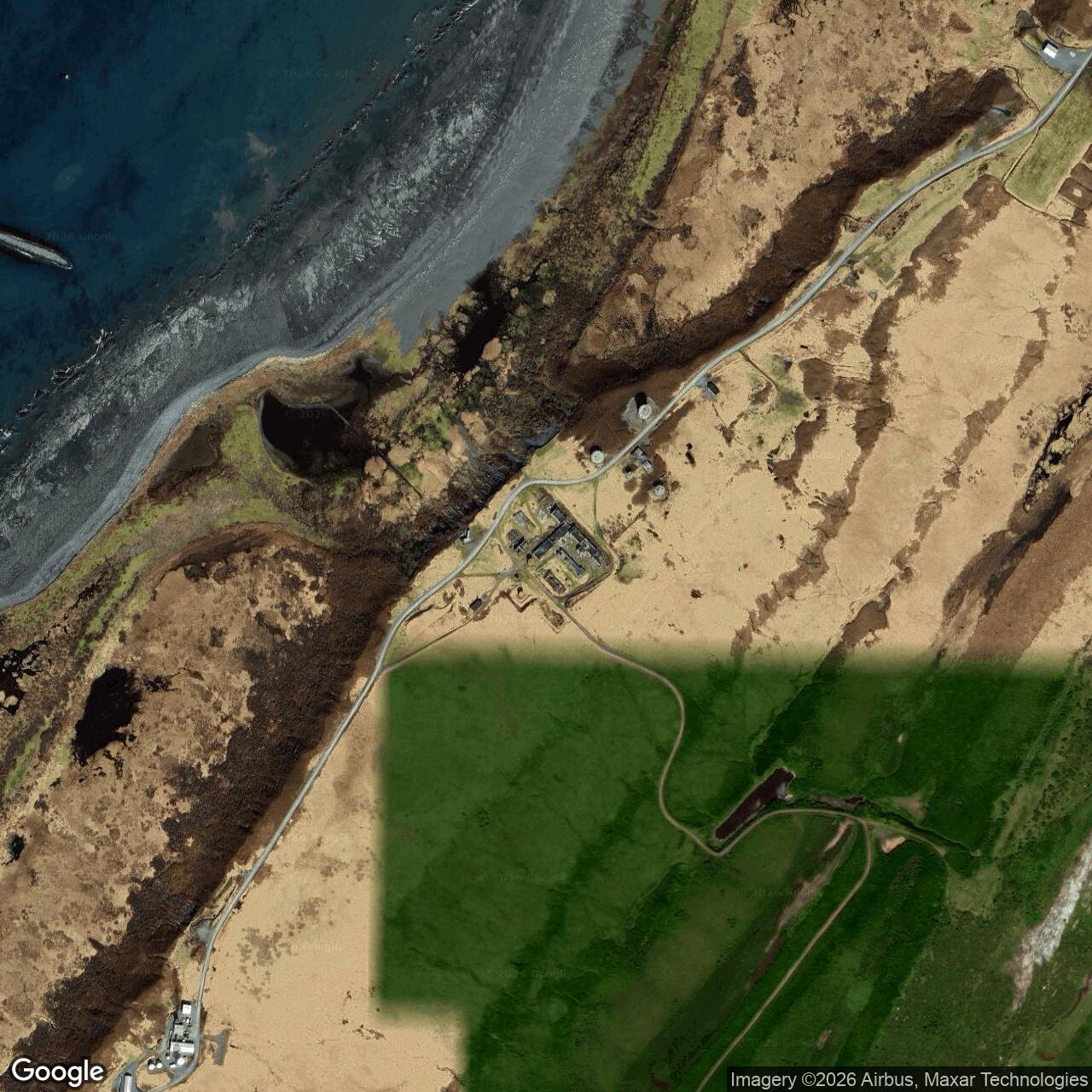
Middleton Island Air Force Station and White Alice Communications Site, Alaska
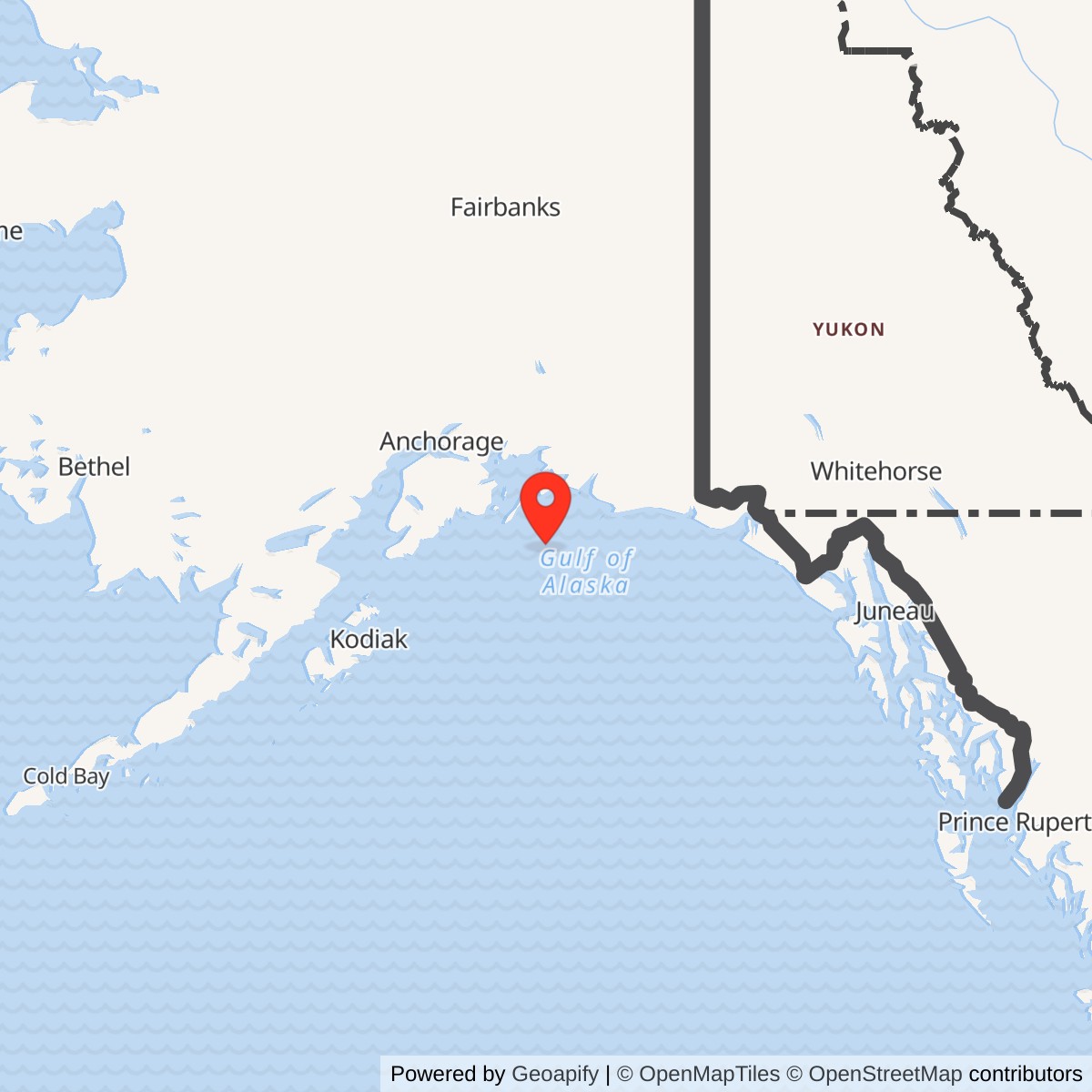
Longitude: -146.329943
Current Role: Former station property used for seabird research by the Institute for Seabird Research and Conservation; separate FAA airport, weather-radar, navigation and communications facilities on Middleton Island. Former radar/White Alice structures survive in varying condition. DEC FUDS and NALEMP cases remain active; current public access is not established.
Coordinate note: A station-center coordinate is not verified. Alaska DEC point 59.449 N, 146.309 W marks a contamination location near former Building 50, not the radar or White Alice center. Its separate NALEMP WGS84 point is also an environmental marker. 59.435973, -146.329943 appears to be the center of the White Alice Installation.
- Radar identity
- F-22, Middleton Island Air Force Station; 720th Aircraft Control and Warning Squadron.
- Radar service
- May 1958 to 15 May 1963; search, height finding, and ground-controlled-interception information.
- Opening equipment
- AN/FPS-3(A) search radar and AN/FPS-6(A) height finder in the 1958 NORAD table; later AN/FPS-20A conversion reported.
- White Alice
- Tropospheric-scatter terminal opened 29 November 1956; direct hop to Boswell Bay, then onward to Neklasson Lake. Communications continued after radar closure.
- Current setting
- Former Air Force buildings support seabird research; FAA aviation facilities and active environmental cases remain on the island.
Overview
Middleton Island carried two related but distinct Cold War missions. Its F-22 aircraft-control-and-warning radar watched the Gulf of Alaska approaches and could provide ground-controlled-interception information. Its co-located White Alice Communications System terminal carried long-distance voice and data traffic through the tropospheric-scatter network. Middleton became an especially important early White Alice endpoint: a formal first-link demonstration reached the island on 29 November 1956, before the permanent radar entered service in May 1958. The radar closed on 15 May 1963, but later records describe continuing communications and FAA reuse. A radar closure date must therefore not be used as the White Alice shutdown date. The surviving Air Force buildings have subsequently served aviation, communications, and seabird research purposes. [1] [2] [3] [4]
Identity, land, and coordinate limits
Middleton Island Air Force Station was the Air Force radar installation designated F-22. The Middleton White Alice terminal was operationally co-located with it but occupied a distinct equipment compound. An earlier engineering survey reproduced in the 1983 Air Force study places the White Alice building roughly one-half mile southeast of the Air Force installation and says White Alice personnel lived in Air Force quarters. The available records therefore support shared support and installation identity, but not the claim that the antennas stood beside the radar towers or inside one building. The island lies in the Gulf of Alaska south of the mainland and was supplied by sea and by its airstrip. Historic sources distinguish an approximately 1,950-acre Air Force reservation or environmental project area from the much smaller 182-acre former-station tract eventually sold to MIDICO and acquired by the Institute for Seabird Research and Conservation in 2011. Neither figure should be described as the present surveyed footprint of the radar towers or White Alice antennas. FAA parcels and Chugach Alaska Corporation land are separate interests on the island. [1] [2] [3] [5] [6]
The previously recorded point 59.449 N, 146.309 W is not a defensible station coordinate. Alaska DEC says it moved that case marker in 2021 to a contaminated location near former Building 50 and east of a fuel line. Its separate NALEMP point, 59.459510 N, 146.307088 W, WGS84, is also a cleanup-case location, not a surveyed radar or antenna position. A site-specific station point remains to be verified from a reliable map or survey. [5] [7]
The 1950 temporary radar and permanent-station construction
An Army Corps account places temporary radar at Middleton in May 1950. That early presence is part of the island's air-defense story, but it does not mean the permanent F-22 installation or its 720th squadron began operational service in 1950. The Corps surveyed Middleton for a permanent ground-controlled-interception site in 1948 and selected it during the mid-1950s extension of Alaska's aircraft-control-and-warning system. Morrison-Knudsen began the permanent construction in 1955. Work included radar and operations structures, power and support facilities, quarters, a 5,000-foot airstrip in the contemporary station account, and facilities for receiving annual sea deliveries. The Mona Lisa and later Cool Barge resupply programs brought heavy supplies; aircraft moved personnel and perishable cargo. The difficult sea approach and frequent bad weather made these systems indispensable rather than incidental. [1] [2]
The 720th Aircraft Control and Warning Squadron was activated in 1955 to operate the future station. Its activation precedes the radar's operational acceptance. The White Alice terminal came on line first, in November 1956. The permanent radar station followed in May 1958. A 1958 NORAD installation table identifies Middleton F-22, the 720th squadron, AN/FPS-3(A) search radar, AN/FPS-6(A) height finder, and a ground-controlled-interception function. The contemporary table is firmer evidence for the opening radar configuration than later unsourced lists of additional AN/FPS-8 and AN/FPS-4 equipment. Those other sets may have been present during installation or as secondary equipment. [1] [2] [8]
Radar operations, 1958 to 1963
The AN/FPS-3 furnished range and bearing of aircraft; the AN/FPS-6 provided height information needed to build a three-dimensional track and guide interceptors. Operators and controllers at Middleton thus contributed to detection and fighter direction over the Gulf approach. This was a ground station, not a fighter airfield. Radar reports moved into the wider Alaskan Air Command control system, which integrated outlying stations with direction centers and aircraft at forward bases. Although a later popular account identifies Fire Island as a receiving center, the primary sources checked here do not establish a dedicated Middleton-to-Fire-Island direct circuit; the history treats that as a network-level relationship, not a verified radio hop. [1] [8]
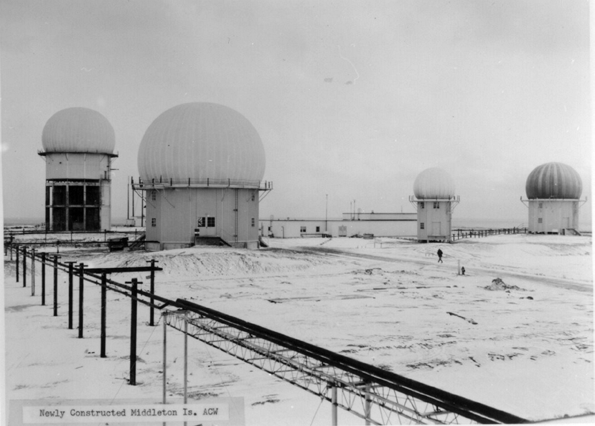
The station's 1950s aerial photograph shows four radome-covered towers, low support buildings, and exposed terrain. It is a historical record of the facility's form, not proof that four separate search radars operated simultaneously. The Argonne history identifies the original operating sets as AN/FPS-3 and AN/FPS-6 and reports conversion to AN/FPS-20A in 1961 to 1962. That latter account relies on a Cloe secondary history. We can therefore state the reported upgrade window while retaining the contemporary 1958 table as the opening baseline. [1] [8]
Middleton was one of three radar sites Alaskan Air Command selected for closure in 1963, with Bethel F-21 and Ohlson Mountain F-25. A contemporary NORAD history describes the decision as an economy and redundancy measure across the Alaskan network. Its combined personnel and cost savings belong to all three closures, not just Middleton. The Corps dates Middleton's radar inactivation to 15 May 1963. The 720th squadron was inactivated in October 1963, allowing for a period of administrative closeout after operations stopped. Closing a radar that had operated for only about five years reflected changes in coverage, cost, and system organization, not the end of all activity on the island. [1] [2] [9]
White Alice communications: an early link and a longer life
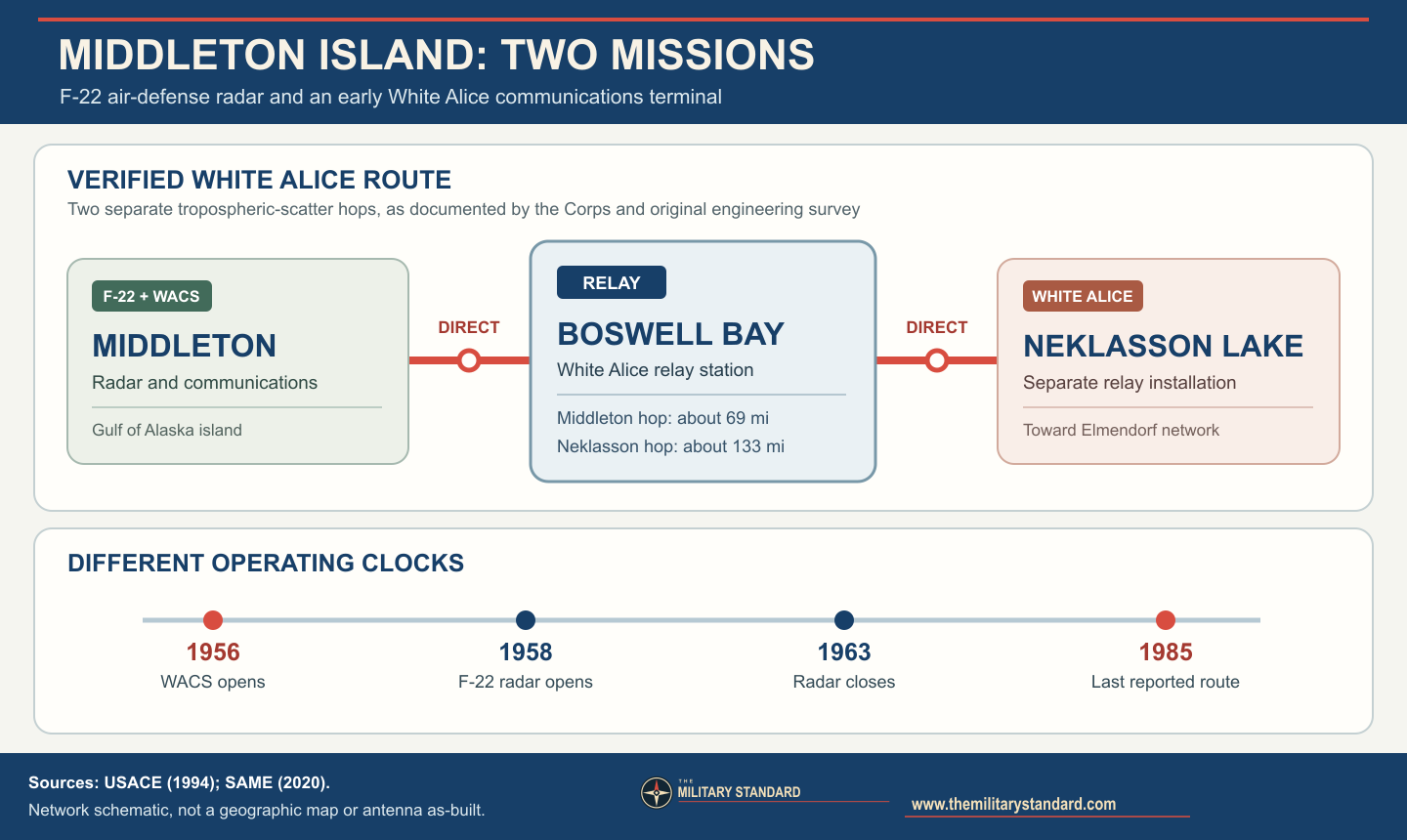
The White Alice terminal met a different problem from the radar. Remote Alaska bases could detect aircraft but still needed reliable voice, teletype, and reporting circuits across water, mountains, and long distances. Tropospheric-scatter transmitters aimed large reflector antennas at the lower atmosphere, allowing beyond-line-of-sight connections. Middleton's four billboard antennas and roughly 4,300-square-foot equipment and power building connected the island to Boswell Bay, approximately 69 route miles away, and onward through Boswell Bay to Neklasson Lake. The 1988 Corps inventory says the building was constructed in six sections and had three small petroleum-storage tanks. An earlier survey reproduced in the 1983 Air Force study describes Middleton as transmitting north toward Hinchinbrook, the Boswell Bay site, with White Alice personnel housed at the Air Force station. The 1994 Corps management plan calls the route a link with Boswell Bay and Neklasson Lake. [2] [3] [4]
There is a specific source conflict about antenna routing. The 1988 inventory's Middleton paragraph says one reflector pair linked Boswell Bay and a second linked Neklasson Lake, placing the latter 130 miles north. But the same report's Boswell Bay entry assigns about 133 miles to the Boswell Bay-to-Neklasson hop, and its Neklasson entry also identifies Boswell Bay as the direct southern endpoint. The 1983 engineering survey mentions only Middleton-to-Hinchinbrook. Taken together, those independent entries and the original network configuration support Middleton-to-Boswell Bay-to-Neklasson as the verified chain. The Middleton paragraph appears to transpose the Boswell-to-Neklasson leg. The report calls Middleton's Boswell-facing reflectors 60-foot billboards while describing 30-foot reflectors at the Boswell end; unequal antenna size at opposite ends is not itself a contradiction. [2] [3] [4]
The first major White Alice route to Middleton was handed over to the Air Force on 29 November 1956 at a ceremony at Elmendorf Air Force Base. The 1983 Air Force special study records a call from Lieutenant General Frank A. Armstrong to Middleton's base commander over a 233.5-route-mile Anchorage-to-Middleton connection. Armstrong had been separated from his command by weather for four days; the successful circuit demonstrated why this network mattered. The 1994 Corps history gives the same 29 November opening and names Boswell Bay and Neklasson Lake as stations on Middleton's route. The ceremony establishes operational service of the first link, not that every later trunk and branch connection was complete on that day. [2] [3]
White Alice is often described as if it ended when a co-located radar site closed. Middleton illustrates why that shortcut fails. The Corps' 1994 site inventory says the White Alice facility was reused by the FAA for other communications purposes. Its 1988 inventory found the original tropospheric equipment removed but antennas still standing and FAA personnel at the site. A later Society of American Military Engineers historical account says the Boswell Bay-to-Neklasson Lake tropo link was the last White Alice connection, used until January 1985 to keep Middleton in the network. That date is a valuable network-level account, but the precise shutdown date for Middleton's own transmitters and the exact FAA handover date were not independently confirmed in the available station records. Alaska DEC's shorthand statement that White Alice operated here from 1956 to 1963 conflicts with these later use records and appears to track the radar closure rather than the full communications history. This history therefore records 1956 opening, post-1963 communications/FAA use, and a reported 1985 final network connection without presenting 1963 as a proven local White Alice shutdown. [2] [4] [5] [10]
People, facilities, and daily operation
The 720th squadron's duty meant maintaining electronic equipment and a small community on an isolated island. The two-story, wood-frame station complex described by the Corps included administrative, dormitory, transmitter, receiver, power, and radome facilities. Its airstrip and marine landing supported every technical function. Weather delayed flights and made the White Alice communications demonstration especially persuasive. A former 720th airman interviewed for the Argonne history recalled service in 1959 to 1960, including social contact with Cordova at New Year 1959. Such recollections do not replace orders or engineering logs, but they help describe how a remote warning post functioned as a lived place. [1] [2] [3]
The 1964 Alaska earthquake uplifted Middleton Island and altered its coastline. That geological event followed radar closure but changed the landscape around the surviving installation. Subsequent FAA navigation, weather, and communications infrastructure occupied separate parts of the island. The FAA installed a WSR-88D weather radar in 1996; that civilian weather radar is not a continuation of the 720th's AN/FPS-3 or AN/FPS-20A air-defense mission. Modern satellite dishes and aviation facilities also should not be mislabeled as original White Alice reflector antennas. [6] [11]
Disposal, research reuse, and historic fabric
The Air Force removed Middleton from its real-estate inventory in October 1966, according to the Argonne history. The same history says the General Services Administration sold a 182-acre tract to MIDICO in November 1977; a 2023 USGS-linked appendix instead dates a MIDICO sale to 1966. The two accounts may have confused inventory removal with final sale, so the precise conveyance should remain qualified pending deeds. The Institute for Seabird Research and Conservation purchased the former-station tract from MIDICO in 2011. Some of the original buildings have been restored or adapted for research, while others have deteriorated. In 1995 researchers adapted a former radar tower with nesting ledges and observation windows for seabird studies. This is a striking reuse of Cold War fabric, but it does not imply that any Air Force radar continued operating there. [1] [6]
The 1994 Corps survey found the installation comparatively intact but deteriorating and called for systematic investigation and evaluation of surviving features. Its White Alice inventory used Alaska Heritage Resources Survey number XMI-010 and recommended preservation consideration. These are survey and eligibility discussions, not proof that every building is presently protected or open to visitors. Contemporary island planning records describe the Institute's 182 acres, FAA parcels, and remaining Chugach Alaska Corporation land. The FAA still maintains the island airport and aviation facilities; researchers use adapted structures and the surrounding habitat. A 2026 Audubon report describes storm damage and repair needs at the seabird tower. Current building condition and access are therefore variable and should be dated, not assumed from a 1985 or 1994 photograph. [2] [6] [12]
Environmental record
The Middleton former defense site is not simply a closed, cleaned property. Alaska DEC maintains an active FUDS case for the former Air Force Station and a separate active NALEMP case associated with the Native Village of Eyak. These are environmental files, not separate installation identities. Historic fuel storage and distribution, transformer oil, and other operations generated potential soil and groundwater concerns. A limited 2005 federal site assessment reported lead, PCBs, and semivolatile organic compounds above background at some samples. EPA's decision not to pursue further action under its Superfund authority did not equal unrestricted cleanup or closure by Alaska DEC. [5] [7]
DEC records describe 2016 authorization to remove approximately 9,100 linear feet of a 4.5-inch fuel pipeline and another 150 feet of smaller line while investigating affected soil. Its earlier schedule projected more investigation and possible future removal, but a projection is not proof the work was finished. The NALEMP file records 2017 pipeline-area samples with diesel-range organics and lead above groundwater-migration cleanup levels and calls for further delineation and removal. DEC's 2021 adjustment of a map point to a contamination location explains why that point must not be recycled as a station coordinate. [5] [7]
Role in the Wider Military Network
Middleton joined surveillance, command, and communications at the edge of the Gulf of Alaska. F-22 supplied aircraft search and height information to Alaskan air-defense control. White Alice gave the island a dependable long-distance circuit before the radar became fully operational and continued to serve aviation or communications needs after the radar was removed. Boswell Bay was Middleton's verified direct White Alice neighbor; Neklasson Lake was the next relay in the route through Boswell Bay. Bethel and Ohlson Mountain were contemporaneous radar stations chosen for the same 1963 economy closure, not Middleton antenna endpoints. [1] [2] [3] [4] [8] [9]
Chronology
- 1948 Army Corps surveys identified Middleton Island as a possible permanent ground-controlled-interception site.
- 1950-05 Temporary radar operated at Middleton, distinct from the later permanent F-22 station.
- 1955 Morrison-Knudsen began the permanent station construction and the 720th Aircraft Control and Warning Squadron was activated.
- 1956-11-29 The first major Anchorage-to-Middleton White Alice link was formally handed to the Air Force and a demonstration call reached the island.
- 1958-05 The permanent F-22 radar station became operational with the 720th squadron.
- 1958-07 A contemporary NORAD table listed AN/FPS-3(A), AN/FPS-6(A), and a ground-controlled-interception function at Middleton.
- 1961-1962 A later Air Force-sponsored history reports upgrade to AN/FPS-20A search radar.
- 1963-05-15 Middleton's air-defense radar was inactivated.
- 1963-10 The 720th Aircraft Control and Warning Squadron was inactivated after operational closure.
- 1964-03-27 The Alaska earthquake uplifted Middleton Island and changed its coastline.
- 1966-10 The former station was removed from the Air Force real-estate inventory, according to the Argonne history.
- 1977-11 The Argonne history dates GSA's sale of a 182-acre former-station tract to MIDICO to this month; another account gives 1966.
- 1985-01 A later military-engineering historical account says the last White Alice tropo link, Boswell Bay to Neklasson Lake, still connected Middleton until January 1985.
- 1988 A Corps White Alice inventory found original tropo equipment removed, antennas standing, and FAA personnel using the site.
- 1994 A Corps heritage survey documented surviving radar and White Alice fabric and called for investigation and preservation consideration.
- 1995 Researchers adapted a former radar tower for seabird nesting and observation.
- 1996 The FAA installed a WSR-88D weather radar on the island, a separate civilian system.
- 2005 A limited federal environmental assessment found some contaminants above background; this did not close the state cleanup cases.
- 2011 The Institute for Seabird Research and Conservation acquired the 182-acre former-station tract from MIDICO.
- 2016 DEC approved fuel-line removal and associated investigation work, not proof of completed island-wide cleanup.
- 2017 NALEMP sampling found diesel-range organics and lead above groundwater-migration criteria near the former fuel line.
- 2021 DEC moved its FUDS case marker to a contamination location, making it unsuitable as a station coordinate.
- 2026 FAA aviation functions, seabird research, surviving historic fabric, and active DEC environmental cases remained associated with Middleton Island.