
Diamond Ridge White Alice Communications Site, Alaska
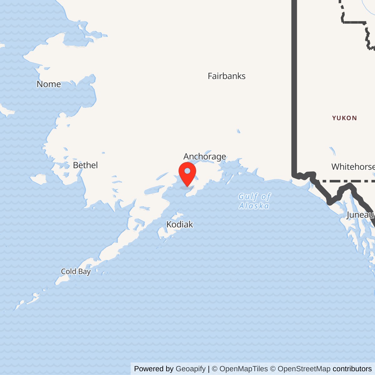
Longitude: -151.606667
Coordinate note: 59.6825 N, 151.606667 W is a DEC/Corps FUDS inventory point for Diamond Ridge RR, not a surveyed original antenna, building, property boundary, or public-access point.
- Mission
- White Alice troposcatter and TD-2 microwave junction near Homer.
- Opened
- March 30, 1957, according to the Corps. The Anchorage route was operating by March 27.
- Direct paths
- Big Mountain and Pillar Mountain by paired 60-foot troposcatter antennas; Starisky Creek by a 63-foot TD-2 microwave tower.
- Later use
- Alascom acquired the station in 1983; Corps surveys observed use in 1988 and 1994. Current circuits are unverified.
Identity and location
Diamond Ridge was a distinct communications station near Homer on the Kenai Peninsula, not a radar station and not another name for Ohlson Mountain Air Force Station. The U.S. Army Corps of Engineers placed it among the three original White Alice installations that combined tropospheric-scatter and TD-2 microwave equipment. Its 1988 roster marks a support or co-location relationship, and a separate Ohlson Mountain radar installation stood in the Homer area, but that mark alone does not put the two plants on one parcel or establish how personnel traveled between them. [1] [2]
An Alaska Department of Environmental Conservation inventory of formerly used defense sites lists Diamond Ridge Radio Relay, Corps number F10AK0090, at approximately 59.6825 N, 151.606667 W. This is an inventory GIS point for the former defense property, not a surveyed antenna foundation, building center, property centroid, boundary, or public entrance. It must not be substituted with DEC's separate Ohlson Mountain cleanup point. The same Diamond Ridge entry identifies an Alaska Native Claims Settlement Act conveyance to Cook Inlet Region, Inc., under patent application 50-82-0042 and labels the entry in a cleanup program. Those are property and program clues, not proof that every part of the former station has the same present owner or that cleanup is complete. [4]
Building the Homer relay
The White Alice network answered an urgent military communications problem: long-distance voice and data paths across Alaska were vulnerable to weather and geography, while the air-defense system needed reliable connections among radar stations, airfields, and commanders. Diamond Ridge was built in 1956 and 1957 as a junction where long troposcatter hops from the southwest and southeast met a line-of-sight microwave route north toward Anchorage. The Corps dates the station's opening to March 30, 1957. A later Air Force study dates the Anchorage-to-Diamond Ridge route becoming operational three days earlier, March 27. These dates describe different milestones and need not be treated as contradictory station-opening dates. The study dates the much longer Diamond Ridge-to-Cape Lisburne route's operational milestone to October 26, 1957, and formal acceptance of the overall White Alice system to March 26, 1958. None of those system dates imply that every station and service was simultaneously complete. [1] [2] [3]
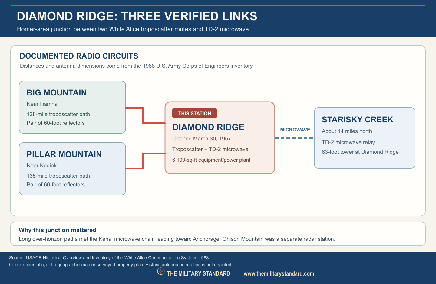
The original installation carried three well-documented direct radio paths. A 63-foot TD-2 microwave tower communicated with Starisky Creek about 14 miles north; Starisky relayed onward through the Kenai Peninsula microwave chain. One pair of 60-foot billboard antennas faced Pillar Mountain near Kodiak, approximately 135 miles to the south. Another pair faced Big Mountain near Iliamna, approximately 128 miles away. These were independent long-distance troposcatter paths: low-angle transmissions scattered in the atmosphere and could reach beyond line of sight. The paired antenna arrangement provided diversity against fading; it was not four dishes all aimed at a single neighbor. The Starisky path used a different, line-of-sight microwave technique. [1] [2]
Mission in the wider White Alice network
Diamond Ridge was the junction of three directions in the original system. The Pillar Mountain path connected Kodiak-area military and other authorized communications to the Kenai Peninsula. The Big Mountain path carried traffic toward the western and interior stations, including King Salmon and Sparrevohn by further relays. The Starisky Creek microwave path led through the Kenai chain to Anchorage and ultimately the wider military communications grid. The Air Force sale study describes the TD-2 network from Diamond Ridge through intermediate repeaters to Anchorage and Fairbanks. It also records the combined station as part of the Air Force communications property later considered for disposal. This does not make Diamond Ridge a radar or a fighter base: its contribution was to transmit and route communications supporting those missions. [1] [3]
The Homer-area Ohlson Mountain Air Force Station was a separate aircraft-control-and-warning radar station. The Corps' asterisk for Diamond Ridge indicates a relationship to an existing military installation in its original-station roster, and the nearby radar site is a plausible operational partner, but the reviewed primary records do not establish a specific cable alignment, measured separation, shared land boundary, or roster of Diamond Ridge operators housed at Ohlson. A direct communications path between radar and relay is a reasonable historical possibility, not a documented circuit to draw as fact. This distinction matters because coordinates, ownership, cleanup status, and surviving structures from one installation must not be copied to the other. [1] [2] [4]
Physical plant and operating work
The 1988 Corps inventory describes the equipment and power building as approximately 6,100 square feet, housing the communications center, generators, radio equipment, and operators' rooms. The 1994 Corps cultural-resources plan identifies the Diamond Ridge building as the concrete-block type used at only a few original White Alice sites, distinguishing it from the common wood-frame composite station buildings. The 1988 survey also identifies a 720-square-foot automotive maintenance shop and 45-square-foot water-supply building. Four petroleum storage tanks together held about 1,000 barrels according to that survey. These are historical construction and storage figures, not a measurement of what remains or of the present parcel. No reliable original acreage has been confirmed. [1] [2]
The equipment building's combination of radio and power rooms reflects the practical burden of keeping a high-power relay operating in Alaska. Beyond the large reflectors, the system needed stable electrical generation, radio racks, switching and monitoring equipment, fuel, maintenance space, and crews able to diagnose fading or equipment faults. The Corps' facility list does not identify a dedicated on-site dormitory in its Diamond Ridge profile. It does not, by itself, establish an exact staffing number, a named Air Force squadron assigned solely to Diamond Ridge, or a verified housing arrangement at Ohlson Mountain. White Alice belonged to Alaskan Air Command's communications network, while contractors and later civilian operators participated in operation and transition. [1] [2] [3]
Role in the Wider Military Network
The station's value was its ability to hand traffic between different propagation methods and regional routes. A circuit arriving over the horizon from Big Mountain or Pillar Mountain could be forwarded over the TD-2 path toward Anchorage, where switching and onward military networks connected Alaska's radar and interceptor system to command centers. This explains the geographic logic of a Homer-area ridge despite the absence of a search radar at the relay itself. It also explains why the Diamond Ridge-to-Anchorage TD-2 path became a civilian service bottleneck once the Kenai Peninsula's demand for long-distance calling grew. The broader White Alice system supported radar warning, command voice, and civil communications, but a particular message path should not be asserted without a circuit record. [1] [3]
The 1975 Kenai Peninsula dispute is a rare window into the network's public consequences. At Alaska Public Utilities Commission hearings in Soldotna on October 3, residents described too few long-distance trunks and delays after a caller reached an RCA operator. The Air Force study records the military's involvement because the Diamond Ridge-to-Anchorage TD-2 route was Air Force property even as RCA Alascom served civilian customers. Governor Jay Hammond pressed for more capacity, and an Air Force approval for a limited RCA overbuild followed in November 1975. An overbuild meant additional RCA-owned channel equipment on existing Air Force infrastructure, not the construction of a new White Alice station. The episode shows that Diamond Ridge had become part of a shared military-civilian communications utility. [3]
Satellite transition and disposal
Satellite earth terminals began displacing many expensive troposcatter links in the late 1970s. The Air Force study says RCA Alascom planned a Kodiak satellite terminal that would allow the Pillar Mountain-to-Diamond Ridge troposcatter link to be deactivated; it also describes planned satellite changes that would end the Big Mountain-to-Diamond Ridge link. These are plans and forecast turn-up dates, not independently verified exact Diamond Ridge transmitter shutdown dates. By 1980, an Air Force electronics installation group was removing troposcatter equipment from six sites being purchased by Alascom, Diamond Ridge among them. Thus the historic sources substantiate a phased end to the original troposcatter mission but do not fix a single closure date for all Diamond Ridge facilities. [3]
The Corps' 1988 inventory says Alascom acquired Diamond Ridge in 1983, the billboard antennas had been removed, and the station was still in use. Its 1994 management plan again reports Alascom use with the large antennas gone. These are dated observations: they do not prove that TD-2 equipment, the original Air Force generators, or any particular circuits were operating decades later. The 1994 plan describes a still-recognizable historical communications property, while Alaska's later statewide Cold War survey classified Diamond Ridge as repurposed. Both sources support reuse of the site, not indefinite continuity of its original military function. [1] [2] [5]
A second civilian phase appears in Federal Communications Commission records. A 1995 FCC order authorized Alascom satellite communication involving Russian satellites and identified a Diamond Ridge earth-station application among the matters before it. A separate FCC authorization described a 9.1-meter C-band Diamond Ridge earth station for video and data connections with the former Soviet Union. These documents show Diamond Ridge's continued importance as a licensed communications location in the satellite era, but a license is not proof that every authorized service was built or continuously operated. A 2005 FCC notice lists a Diamond Ridge earth-station coordinate near 59.6811 N, 151.6222 W in a withdrawn license-renewal matter. That coordinate is an FCC facility record, not the historic 1957 antenna-site location and not a substitute for the Corps/DEC FUDS inventory point. The withdrawal does not, by itself, prove the whole property was abandoned. [6] [7]
Environmental and present-condition evidence
Federal and state inventories continue to identify a Diamond Ridge Radio Relay formerly used defense property as F10AK0090. The 2021 DEC list labels it conveyed and in a cleanup program; a federal historical inventory also recognizes the FUDS number. Neither short list provides a contaminant-by-contaminant cleanup history, a final remedy, a parcel survey, or a current site-access determination. The potential for fuel and electrical-equipment legacy is an investigative context given the original plant, not a verified finding of a specific release at Diamond Ridge. A dedicated cleanup report would be needed before stating contaminant concentrations, restrictions, or completion. The 1994 Alascom-use statement and later FCC satellite records likewise cannot establish that the original 60-foot reflectors or every original building remain in 2026. [1] [2] [4] [8]
Chronology
- 1956 Construction began on the mixed troposcatter and TD-2 station near Homer, according to the Corps.
- 1957-03-27 The Air Force sale study dates the Anchorage-to-Diamond Ridge route becoming operational.
- 1957-03-30 The Corps dates the Diamond Ridge station opening to this day.
- 1957-10-26 The Air Force study dates the Diamond Ridge-to-Cape Lisburne route operational milestone.
- 1958-03-26 The original White Alice system received formal overall acceptance; not a second Diamond Ridge opening.
- 1975-10-03 Soldotna hearings addressed shortage and delays on the Diamond Ridge-to-Anchorage TD-2 service.
- 1975-11 The Air Force authorized a limited RCA Alascom overbuild to relieve Kenai Peninsula capacity problems.
- 1977-1978 Satellite terminal plans projected retirement of the Pillar Mountain and Big Mountain troposcatter paths; exact local cutover days remain unverified.
- 1980 Air Force installation personnel removed deactivated troposcatter equipment from Diamond Ridge among six sale-related sites.
- 1983 The Corps later reported that Alascom acquired the station.
- 1988 The Corps found the billboard reflectors removed and the facility still in Alascom use.
- 1994 The Corps cultural-resources plan again described Alascom use and removed billboards.
- 1995 FCC records documented Alascom authorization involving a Diamond Ridge C-band earth station.
- 2005 An FCC notice listed a Diamond Ridge earth-station renewal among withdrawn matters; this is not proof that the whole site closed.
- 2021 Alaska DEC listed Diamond Ridge RR, F10AK0090, as an ANCSA-conveyed former defense property in a cleanup program.
Information sources (10)
- PDFU.S. Army Corps of Engineers, Historical Overview and Inventory: White Alice Communication System, 1988
Source for: station identity, March 30 opening, Starisky, Pillar Mountain and Big Mountain links, plant buildings and fuel storage, 1983 Alascom acquisition, and 1988 condition.
- PDFU.S. Army Corps of Engineers, The Cold War in Alaska: A Management Plan for Cultural Resources, 1994
Source for: concrete-block building design, 1994 Alascom-use observation, and removed billboard antennas.
- PDFU.S. Air Force, A Special Study of the Sale of the White Alice Communications System, 1987
Source for: 1957 route milestones, 1975 Kenai TD-2 overbuild dispute, satellite replacement plans, and 1980 equipment removal.
- PDFAlaska Department of Environmental Conservation, ANCSA Conveyed Contaminated Sites Inventory, 2021
Source for: F10AK0090 Diamond Ridge RR, approximate GIS point, conveyance identifier, and cleanup-program listing; not for a final remedy.
- PDFAlaska Office of History and Archaeology, The Coldest Front: Cold War Military Properties in Alaska
Source for: statewide historic context and later repurposed-site classification, not current operation.
- PDFFederal Communications Commission, Memorandum Opinion, Order, and Authorization DA 95-1342, 1995
Source for: satellite-era Alascom authorizations involving the Diamond Ridge earth-station application.
- PDFFederal Communications Commission, Public Notice DOC-258522, 2005
Source for: later Diamond Ridge earth-station coordinate and withdrawn renewal context; not a site-wide closure date.
- WEBU.S. General Accounting Office, Formerly Used Defense Sites inventory for Alaska
Source for: independent federal listing of Diamond Ridge RR as F10AK0090, not cleanup outcome.
- WEBUniversity of Alaska Anchorage, Leland A. Olson papers, White Alice site near Homer photograph
Source for: site-specific photographic lead and explicit archive-rights warning; photograph not republished.
- PDFAnchorage Museum, Bill Ray White Alice collection finding aid
Source for: additional original photographic holdings and Diamond Ridge/Homer indexing; reuse rights must be checked.