
Granite Mountain Radio Relay Station, Alaska
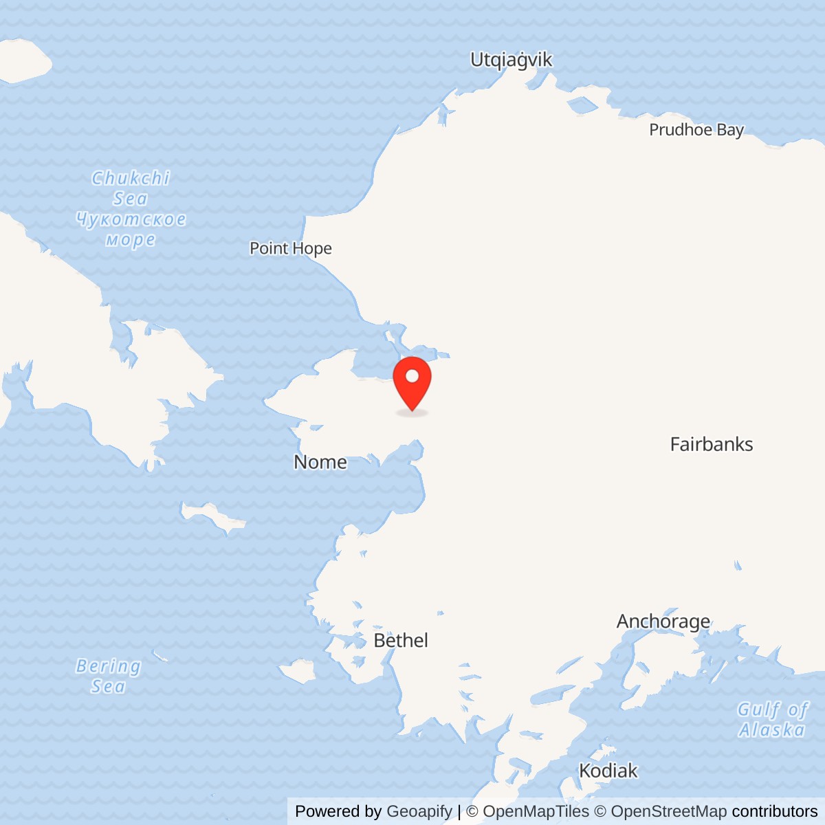
Longitude: -161.236111
Current Role: Former relay property north of Koyuk; Alaska DEC reports site-wide cleanup complete, with institutional controls at selected areas. Current occupancy, title and access require review.
Location: Seward Peninsula isthmus, north of Norton Bay. Alaska DEC site-wide NAD83 environmental marker: 65.432222 N, 161.236111 W. This is not a surveyed antenna point, installation centroid or property boundary.
- Role
- White Alice communications relay, not an aircraft-search radar station.
- Activated
- May 25, 1957, according to the U.S. Army Corps of Engineers station inventory.
- Original links
- North River, Anvil Mountain and Kotzebue.
- Historical site
- 257.8 acres with Upper, Mid Mountain and Lower Camp areas, a gravel runway and about 3.2 miles of road and waterline right-of-way.
- Present condition
- Radio installation demolished; selected cleanup areas remain under land-use controls. Exact current title and access terms are unverified.
Identity and significance
Granite Mountain Radio Relay Station was a U.S. Air Force communications installation on the isthmus of Alaska's Seward Peninsula. It belonged to the original White Alice Communications System, a network built to carry military and civilian messages across vast distances where conventional lines were difficult to install and maintain. Granite Mountain connected three separate White Alice stations: North River, Anvil Mountain and Kotzebue. It was a relay, not an aircraft-search radar station. The paired reflector antennas aimed at fixed communications destinations rather than rotating to search the sky. Alaska's environmental database sometimes calls the property Granite Mountain Air Force Station, but that administrative label does not turn the radio relay into a separate radar installation. [1] [2] [3]
Granite Mountain is especially useful for understanding White Alice as an engineered network rather than as a collection of picturesque antennas. Two long paths used 60-foot tropospheric-scatter reflectors; the shorter Kotzebue path used a pair of 30-foot dishes. The station included power generation, fuel storage, sleeping quarters and an airfield support area, because a radio path could not operate reliably without people and supplies. After its communications role ended, Granite Mountain became a case study in the competing demands of Cold War preservation, remote-site demolition, contaminated-land cleanup and continued control of buried wastes. The U.S. Army Corps of Engineers recommended the intact station for preservation and reuse in 1994; the later Air Force cleanup program removed major structures in 2009. These are different points in the site's chronology, not mutually exclusive descriptions of one unchanged place. [1] [2] [3] [5] [6]
Where the station stood
The Corps' 1994 cultural-resources plan locates the station north of Norton Bay, approximately 120 miles northeast of Nome and 12 miles north of Dime Landing, with access by air. Alaska Department of Environmental Conservation (DEC) gives the site-wide environmental case a NAD83 point of 65.432222 N, 161.236111 W. A separate DEC case for the former White Alice equipment-building area, called OT001, has a WGS84 point of 65.428000 N, 161.232700 W. They label different environmental case areas at one installation. Neither point is a surveyed antenna center, station centroid or property polygon. The two case numbers are not evidence for two Granite Mountain military installations. [2] [3] [4]
A 2006 Norton Sound inventory describes an upper camp and lower camp joined by a 3.2-mile road. Its upper camp had the radio array, equipment and power building, dormitory, vehicle-maintenance shop, three petroleum, oil and lubricants tanks, and a water tank. The lower camp had an air terminal, storage building, fuel tank and runway. This makes the old station larger than the compact hilltop antenna field alone. The lower camp made delivery of personnel, fuel, food, parts and construction materials possible, while the road tied those functions to the operating site. That source's component description relies on earlier studies identified in its text. It is a useful historical inventory, not a current property survey or a guarantee that each building still stands. [5]
The 2011 Air Force decision documents give the historical station area as 257.8 acres. They identify Upper Camp, Mid Mountain and Lower Camp, plus a 4,000-foot gravel runway and approximately 3.2 miles of road and waterline right-of-way. A 2023 Air Force preliminary assessment instead calls the runway approximately 3,500 feet long. The discrepancy may reflect different measurement methods or endpoints; neither report supplies a runway survey resolving it. The 2011 record says the Department of Defense withdrew federal land for military use in 1958, while associated activity also extended onto state-managed land. The 1981 notice of intent to relinquish had lapsed by the time of the 2011 decisions. The Air Force then intended to relinquish most withdrawn land after cleanup, while retaining responsibility for controlled disposal areas, including some on state land. Intent is not proof of completed conveyance. Exact present parcel title and access terms require current land-status records. [2] [8] [9] [10] [11]
Why White Alice was needed
Alaska's radar stations and airfields could not serve as an integrated early-warning system if reports and orders moved too slowly between them. The distances and terrain made a dense wired network costly. The 1988 Corps history describes the limitations of earlier Alaska communications, including very restricted voice capacity between distant communities. Planners wanted a network able to carry defense information and public telephone traffic across large gaps despite winter conditions and intermittent propagation problems. The Alaska Communications Study Group was formed in 1954, and the Bell System recommended a combination of long tropospheric-scatter routes and shorter line-of-sight microwave routes. Western Electric received the contract for the original White Alice system in 1955. The Corps surveyed and contracted for some original stations; Western Electric installed electronics across the system. The records reviewed here do not identify the exact construction contractor or contract number for every Granite Mountain structure. [1]
Tropospheric scatter sends a powerful, tightly focused radio beam above the normal horizon. A small fraction of the energy scatters from irregularities in the lower atmosphere and can be received at a station too distant for a straightforward line-of-sight path. Large, carefully oriented reflectors and antenna pairs were part of the answer to variable propagation over the long Alaska circuits. The reflectors were commonly nicknamed billboards, but their surface shape and feed arrangement belonged to a radio antenna, not a flat roadside sign. Granite Mountain's antenna field must therefore be depicted as a communications installation. [1]
Construction and activation
The Corps' 1988 station inventory says Granite Mountain was built during 1956 and 1957 and activated on May 25, 1957. Its later 1994 account repeats that activation date. The 2006 Norton Sound report says the station was turned over to the Air Force in 1957, although the underlying acceptance certificate was not available for this audit. The activation date is a Granite Mountain milestone and should not be confused with White Alice's network-wide public inauguration or the later completion of other stations. The existence of a working route depended on readiness at both ends of each link, so a date for one station cannot automatically be assigned to every partner terminal. [1] [2] [5]
Building a remote relay involved more than erecting reflectors. The Corps' 1988 inventory gives 7,520 square feet for Granite Mountain's combined equipment and power building and 5,200 square feet for its dormitory. The latter is evidence that the station was designed for resident staff, unlike a nearby-town site where workers could commute. The same inventory reports three fuel tanks with a combined 7,000-barrel capacity, approximately 294,000 U.S. gallons. This is a historical installed-capacity figure, not a measurement of actual fuel inventory at any given date, and it does not include every lower-camp tank described in other inventories. Diesel generation and reserve fuel were core communications infrastructure at a mountain relay far from a dependable public grid. [1] [5]
The upper and lower camps also shaped daily work. The lower-camp runway and air terminal made aircraft supply practical; the 3.2-mile road still had to connect the airfield to the work site. The upper-camp dormitory, water tank, vehicle shop, equipment building and fuel storage show that technicians could not simply visit the antennas and leave. The site was an occupied operating plant exposed to difficult weather and isolation. The 2023 Air Force assessment additionally identifies a small fire station, temporary air terminal, heated vehicle-operations building and staging areas by the lower-camp runway. It gives the fire station as 126 square feet and says only its foundation remained by a 2000 survey. These details are more precise than a generic description of a remote White Alice camp. Available sources still do not establish annual staffing counts, contractor-by-contractor shifts or an exact communications-room cabinet roster. [1] [5] [11]
The three verified communications paths
The 1988 Corps inventory identifies a pair of 60-foot reflectors toward North River, roughly 108 miles away; another 60-foot pair toward Anvil Mountain near Nome, about 136 miles away; and two 30-foot dishes toward Kotzebue, about 105 miles away. These are historical route distances, not surveyed foundation-to-foundation measurements. The inventory's compass directions are inconsistent with the approximate positions in current environmental mapping, so this history does not use them to draw a geographically precise map. The 1994 Corps plan describes the same three terminals but rounds the Anvil path to approximately 130 miles. Its differing figure should be treated as an estimate rather than silently replacing the earlier 136-mile figure. The route identities are more certain than the exact mileage. [1] [2] [3]
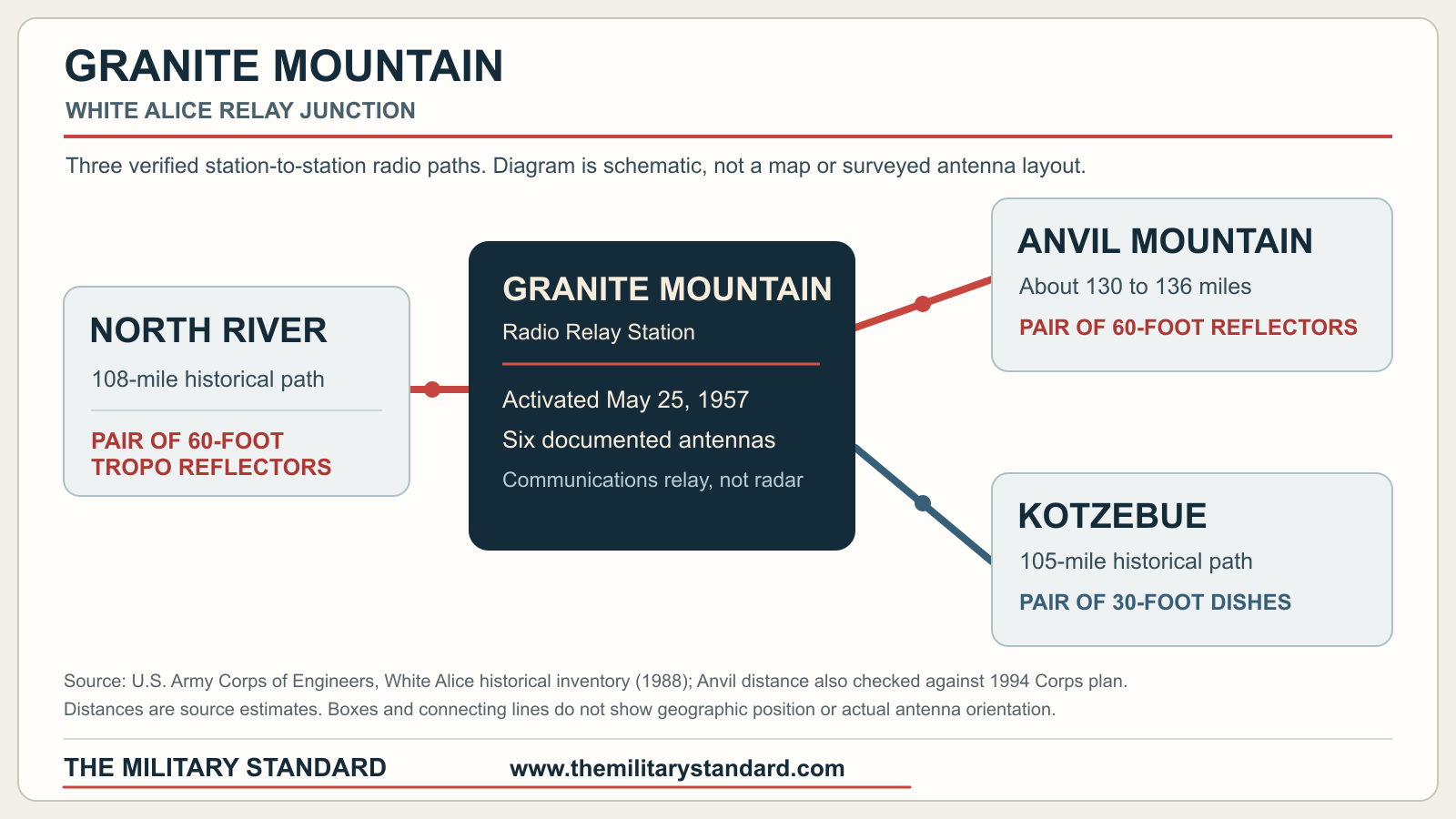
North River was a separate White Alice radio relay in the Unalakleet region. Its connection to Granite Mountain continued the chain southeast toward Kalakaket Creek and other parts of the network. Anvil Mountain was a separate mountain relay near Nome, with its other original path across the Bering Sea toward Northeast Cape. Kotzebue provided a northern connection onward to Cape Lisburne. These relationships explain why Granite Mountain had three antenna pairs rather than one. They do not make the remote stations subareas of Granite Mountain, and they do not prove that every distant radar report used every route at every date. [1] [2]
White Alice service also intersected civilian communications, but the site-specific record does not provide an inventory of telephone, telegraph, data or control circuits passing through Granite Mountain in each year. The same caution applies to equipment names. The 60-foot and 30-foot antenna classes, building sizes and fuel capacity are documented; the model and serial number of the transmitter, receiver, switching frame or power generator at Granite Mountain have not been established in the sources located. General descriptions of White Alice technology explain possible functions, not the station's exact cabinet roster. [1]
Operation, later users and changing purposes
The Corps records that Granite Mountain was leased to Alascom in 1976. The 2011 decision documents describe RCA Alaska Communications, later Alascom, as the operator before the lease and place that transition within the Alaska Communications Disposal Act process that began in 1967. The petroleum decision document says a newer satellite communications system was installed, but does not establish when every old radio circuit stopped. A lease was therefore a change in operating or property arrangement, not proof that every military circuit ended on that exact day. DEC says the White Alice site was declared excess in 1978. A 2006 inventory describes the relay as closed in 1978. DEC's broader 1956-1980 active-use notation is environmental shorthand, not an independently verified final radio-service date. The last on-air day, last resident crew and complete leased-equipment inventory remain unknown. [1] [3] [5] [8] [9]
The 1994 Corps plan records uses that followed or overlapped the decline of the original White Alice role. It says the Bureau of Land Management used various facilities in summer as a headquarters for interior Alaska firefighting operations. The 2023 Air Force assessment narrows the documented BLM use to roughly 1976 through at least 1998 and says portions of the facility were leased to BLM and FAA in 1986. It also reports the runway was used for BLM fuel staging. The Corps recorded a Federal Aviation Administration single-frequency outlet in the southernmost tropospheric antenna structure, Antenna No. 1. These are specific reasons not to describe the whole property as simply unused after White Alice. They are dated evidence and do not prove BLM or FAA use continues in 2026, or that Antenna No. 1 survived later demolition. [2] [10] [11]
Airfield operations had their own risks. The 2023 assessment cites an accident report for a Fairchild C-82A-FA that crashed while landing at Granite Mountain on August 3, 1964; the aircraft caught fire. In 2023 investigators saw aircraft wreckage near lower-camp DP010 and identified a part consistent with the C-82A. The accident report reviewed for the assessment did not establish the exact firefighting response. The assessment specifically cautions that AFFF was not used by the Air Force before 1970, so the 1964 crash is not evidence of AFFF use or a PFAS release. The crash is part of this relay station's airfield history, not evidence for a separate air base identity. [11]
The station's physical condition and official status changed again after that survey. In 1994, the Corps regarded Granite Mountain as retaining much of its original integrity, and its cultural-resources plan recommended the site as the representative common-design White Alice station to preserve or adapt. It suggested a remote lodge or housing for firefighting operations as one possible reuse, while warning that character-defining features needed attention. The plan assigns Alaska Heritage Resources Survey number CAN-028 and describes the station as a high-priority preservation candidate. Those were recommendations and an assessment at that date, not evidence that preservation was ultimately carried out. The report's broad wording about National Register status for White Alice should not be converted into an unverified claim of individual listing for this parcel. [2]
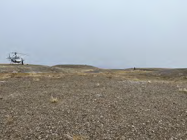
The 2006 Norton Sound inventory, citing earlier cultural-resource work, still described radio antennas and buildings as intact at the time represented by its sources. A legislative defense briefing reports that the Air Force's Clean Sweep program undertook major Granite Mountain demolition and cleanup during fiscal year 2009. The 2023 Air Force preliminary assessment is more definitive about the current physical scene: after site walks, its team reported that all upper-camp infrastructure had been removed and the landscape modified by Clean Sweep. At lower camp, the team found one dilapidated unidentified structure near the former fire-station area, while other infrastructure had been removed. The 1994 intact-building description must not be copied into a present-tense page. Nor should the 2023 findings be enlarged into a claim that every foundation, buried remnant or artifact is gone. [3] [5] [6] [11]
Early environmental concern
The station left a large fuel and waste-handling footprint. DEC's site-wide case reports a 1981 inspection that found contaminated transformers and capacitors, drums and containers, acids, asbestos and other suspect materials. It records an interim removal in 1982 without adequate detail to state exactly what was taken away. A 1983 visit noted about 200 drums at the airstrip and fuel in two tanks. DEC says PCB material was removed in 1986 and transported to Elmendorf pending disposal. These are dated observations and actions. A list of possible contaminant types is not proof that each substance contaminated each sampled area; DEC expressly says it could not substantiate all items in the inherited site-wide problem statement. [3]
Landfill control was another early issue. DEC's record lists solid-waste permits and a denied 1990 permit application pending site assessment. A 1991 inspection found covered landfills and battery packs at the summit and reported a concern about notification of closure. The regulator later treated the former White Alice operating area and the landfill as different investigation areas, OT001 and LF002, within one broader Granite Mountain property. This distinction matters for a history: a cleanup decision at OT001 cannot automatically be extended to every fuel tank, disposal pit or lower-camp area. Nor does a landfill name create a second base. [3] [4]
A 1994 preliminary assessment summarized past petroleum spills, PCB-affected soil and large numbers of stored drums. The Air Force's 1995 relative-risk worksheets assigned a high rating to the White Alice area and a lower one to the landfill at that time. These were screening priorities, not a permanent measure of all current exposures. Field investigation and community discussion continued into the next decade. DEC's chronology says its staff rejected the first 1999-2000 baseline risk assessment because required risk procedures were not followed. At public meetings in Buckland and Koyuk in October 2000, residents expressed concern about human and ecological risk. This history does not reduce that process to a simple assertion that the site was safe or unsafe. It records the evolving evidence and the regulator's objections before the later remedy was chosen. [3] [5]
Characterization and cleanup
DEC describes the former equipment-building area, OT001, as a PCB problem centered around soil outside the building's north and south doorways. Sampling in 1994, 1999 and 2008 found a wide range of PCB concentrations, with the latter investigation reporting values up to 442.37 milligrams per kilogram in its summary. The site-wide case also documents petroleum and other areas of concern elsewhere in upper and lower camp. A supplemental investigation in 2008 better delineated soil impacts so that remedial work could be planned. These concentrations are measurements in particular samples, not an average for the entire mountain or proof of a human dose. [3] [4]
The 2009 cleanup combined building demolition, debris handling, petroleum-soil management and PCB excavation. DEC says 487 cubic yards of PCB-affected soil were excavated from OT001. About 129 cubic yards above 10 milligrams per kilogram were shipped off site. About 358 cubic yards below that threshold were placed in two concrete vaults made from former billboard-antenna foundations. A mechanical-chemical destruction treatability experiment was attempted on site, but the scaled-down equipment did not consistently meet the cleanup goal; DEC reports that only 18 cubic yards were successfully treated below 10 milligrams per kilogram. These quantities should not be conflated with the station-wide volume of all demolished material or petroleum soil. The antenna foundations acquired a new environmental function as engineered disposal features, which is important when interpreting the site after demolition. [3] [4]
DEC's account says petroleum-contaminated soil was landspread at upper camp and, after confirmation sampling met health-based criteria, used as cover at a construction and debris landfill. The now-reviewed January 2011 CERCLA record of decision and separate state-law petroleum decision document established different remedies for different source areas. The CERCLA record identifies OT001 as the remaining PCB-controlled unit. It selects no further CERCLA action for LF002, DP009, SS003, SS013 and DA015 after assessment or removal. That is not a universal release of the property from other controls. The separate petroleum and solid-waste decision places institutional controls on LF002, DP009, DP010, SS016, SS017, SS019, DA020 and DA021. Most address possible buried waste and limits on excavation or movement; SS017 specifically addresses diesel-range-organic contamination in groundwater. Other identified units received cleanup-complete determinations without the same continuing remedy. DEC's site-wide cleanup-complete determination in 2014 reflects those chosen remedies, not unrestricted excavation, universal absence of contamination or general public access. [3] [4] [8] [9]
At OT001, the capped PCB soil remained in the on-site monofill. The 2011 CERCLA decision describes soil above 10 milligrams per kilogram removed off site and soil between 1 and 10 milligrams per kilogram placed on site beneath at least two feet of clean fill. The Air Force must maintain the cap, mark it, restrict digging and soil movement, monitor the controls and provide notice before any property transfer affecting them. Five-year CERCLA reviews continue while the capped PCB material exceeds the unrestricted-use level of 1 milligram per kilogram. The decision also requires reports to DEC and the Koyuk Indian Reorganization Act council. The petroleum decision separately protects SS017 groundwater and several buried-waste areas. Thus an area can be 'no further action' under CERCLA yet remain controlled under state solid-waste or petroleum authority. [8] [9]
The 2023 long-term management team inspected lower-camp DA021 and DP010 on July 5 and seven upper-camp controlled areas on September 16. It found covers largely unchanged and in good condition, repaired three warning signs, and installed a new one at DP010. DA021 lacked a sign, so the final report recommended adding it during the next planned management visit in 2028. At OT001, the team reinstalled a detached warning sign and found the cap in good condition. It also observed apparent use of the airstrip by miners working roughly one mile west of the runway. This is a dated observation of airstrip reuse, not proof of an Air Force aviation mission or authorization for the public to enter restricted areas. DEC approved the final report on August 20, 2024. A 2025 DEC entry records review of a draft notice of activity and use limitation for OT001, focused on preventing disturbance and movement of PCB-affected soil. [3] [4] [10]
Other environmental questions continue to be screened separately. The Air Force's December 2023 AFFF preliminary assessment found a 2001 management-plan reference to fire training during 1957-1975, but no record giving its precise location or method. In an interview, a former Air Force civilian employee recalled seeing 15 to 20 empty five-gallon AFFF jugs in the lower-camp heated vehicle building and a foam-equipped fire trailer nearby during later work; he could not identify a Granite Mountain fire-training event. The report recommended a site inspection for two possible lower-camp release areas: the former fire-station area and DP010 by the runway. It recommended no further AFFF response at the upper-camp DP009 burn area and water fire-pump station, based in part on the employee's account that upper-camp fires were controlled with water. DEC also requested later consideration of possible non-AFFF PFAS sources. These are preliminary screening decisions, not proof of a PFAS release, measured PFAS concentration or a completed site inspection. They do not undo the earlier decisions for PCB and fuel contaminants. [3] [11]
Preservation, photographs and the present record
Granite Mountain has a notable archival record. The University of Alaska Anchorage's William F. McDowell collection lists Granite Mountain in official Air Force photograph groups showing White Alice stations, generators and construction justifications. Its finding aid says the collection has not been digitized and invites inquiries about copies. The Air Force's 2023 preliminary assessment and long-term management report, now reviewed, include actual dated site photographs of the post-demolition upper and lower camps. The former includes an aerial oblique view of Upper Camp; the latter documents OT001 and other controlled areas. These are verified Granite Mountain images but are not operational-era antenna photographs. [7] [10] [11]
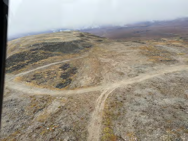
The visual story already established by documentary sources is compelling without invention: a high and low camp connected by a long road; six antennas aimed in three directions; resident quarters and a large power-and-equipment plant; later reuse, abandonment, preservation recommendation, demolition and capped antenna foundations. A verified route diagram could convey the communications relationships. A footprint or reconstruction graphic would require the as-built plans or dated aerial image before claiming exact building positions. [1] [2] [3] [5] [7]
Research limits and interpretation
The strongest site-specific operating source remains the Corps' 1988 inventory, backed by its 1994 management plan. The two full 2011 decision documents resolve the earlier uncertainty about the acreage, component areas and legally distinct cleanup remedies. The 2023 long-term management and AFFF reports supply dated field observations, an employee interview, and verified recent photographs. The 2006 Norton Sound inventory helps reconstruct the camps and reports community concern. Its passing reference to an 'active USAF station nearby' has not been corroborated as a distinct radar installation. Important limitations remain: current title instruments, precise circuit-shutdown records, exact radio-equipment model rosters, operational-era site photographs and final as-built demolition mapping. [1] [2] [3] [5] [7] [8] [9] [10] [11]
The central historical distinction is between a site, a mission and the changing use of land. Granite Mountain was one communications installation with multiple component areas and environmental case identifiers. Its three original routes made it a western-Alaska network junction. Lease and excess actions did not necessarily occur on the same day as circuit shutdown. In 1994, preservation of its intact engineering fabric still seemed feasible; by 2009, a different public responsibility, removal and containment of environmental hazards, had physically transformed the site. The remaining historical task is to document that transformation precisely, not to freeze Granite Mountain in a picturesque 1957 or 1994 view. [1] [2] [3] [4] [5] [6]
Chronology
- 1954 The Alaska Communications Study Group is formed to address long-distance communications needs.
- 1955 Western Electric receives the original White Alice network contract.
- 1956-1957 Granite Mountain Radio Relay Station is constructed.
- 1957-05-25 The Corps' station inventory records Granite Mountain's activation.
- 1958 Federal land is withdrawn for military use, although station activity also reaches state-managed land.
- 1964-08-03 A Fairchild C-82A-FA crashes and burns while landing at the Granite Mountain airstrip.
- 1967 The Alaska Communications Disposal Act begins the transfer framework for government long-distance communications.
- 1976 The Corps records a lease to Alascom; the exact effect on individual circuits is not documented here.
- 1978 DEC records the White Alice site as declared excess; a later Norton Sound inventory describes the station as closed this year.
- 1981-06-03 The Corps reports a notice of intention to relinquish the station forwarded to the Bureau of Land Management.
- 1981-08-26 DEC records a field inspection that identified suspect material at the former station.
- 1983-04-15 DEC records drums and residual fuel at the airstrip and in tanks.
- 1986 DEC records PCB material removed for transport to Elmendorf pending disposal.
- 1994 The Corps describes Granite Mountain's surviving integrity and recommends preservation and reuse of this station as a White Alice example.
- 1994-08-17 DEC receives a preliminary assessment and approves a site-inspection work plan, subject to coordination over landfill investigation.
- 1999 Remedial investigation fieldwork examines PCB and other concerns.
- 2000-10 Air Force and DEC discuss findings with residents at Buckland and Koyuk; DEC has challenged the initial risk assessment.
- 2008 Supplemental investigation further delineates contamination before cleanup.
- 2009 The Air Force's Clean Sweep work includes Granite Mountain demolition and environmental remediation.
- 2009-2010 PCB soil is excavated; the on-site treatment demonstration has limited success; selected material goes off site and lower-concentration material into capped former antenna foundations.
- 2011-01 The CERCLA record of decision and separate petroleum and solid-waste decision document establish distinct remedies and institutional controls.
- 2014-07-22 DEC records site-wide cleanup complete, with institutional controls at selected areas.
- 2019-11-06 DEC accepts a five-year review finding the OT001 controls effective at that date.
- 2023-07-05 Air Force contractors inspect the lower-camp controlled areas and document physical conditions.
- 2023-09-16 Air Force contractors inspect upper-camp controlled areas and document the post-demolition landscape.
- 2023-12-18 DEC approves the final AFFF preliminary assessment recommending site inspection of two potential lower-camp fire-training areas.
- 2024-08-20 DEC approves the final 2023 long-term management report.
- 2025-04-11 DEC reviews a draft notice restricting disturbance of the OT001 cap and affected soil.
Information sources (11)
- PDFU.S. Army Corps of Engineers, Historical Overview of the White Alice Communications System, 1988
Source for: Granite Mountain construction, activation, routes, antenna dimensions, buildings, fuel capacity and Alascom lease; White Alice technical and network context.
- PDFU.S. Army Corps of Engineers, The Cold War in Alaska: A Management Plan for Cultural Resources, 1994
Source for: Granite Mountain location, FAA and BLM reuse, 1981 relinquishment notice, preservation assessment, AHRS CAN-028, and approximately 130-mile Anvil route estimate.
- WEBAlaska Department of Environmental Conservation, Granite Mountain AFS - Site Wide, Hazard ID 846
Source for: NAD83 site-wide location marker, environmental investigation chronology, excess status, 2009 cleanup, 2011 decisions, 2014 regulatory closure, 2023-2025 monitoring and use controls.
- WEBAlaska Department of Environmental Conservation, Granite Mountain AFS OT001, Hazard ID 776
Source for: distinct former White Alice equipment-building cleanup area, WGS84 case point, PCB concentrations and excavation volumes, disposal in former antenna foundations, failed treatment demonstration, cap and controls.
- PDFAlaska Community Action on Toxics, Report on Formerly Used Defense Sites in the Norton Sound Region, 2006
Source for: upper and lower camp components and 3.2-mile road, 1978 closure account, pre-demolition condition, public concerns expressed during 2000 meetings. Historical descriptions are attributed to its underlying cited studies where available.
- PDFAlaska Legislature, Joint Armed Services Committee briefing materials, 2011-2012
Source for: fiscal-year 2009 Clean Sweep demolition and cleanup at Granite Mountain and Kalakaket Creek.
- WEBUniversity of Alaska Anchorage Archives and Special Collections, Guide to the William F. McDowell Papers
Source for: existence and location of Granite Mountain official Air Force photographic material and its undigitized status.
- PDFU.S. Air Force and Alaska Department of Environmental Conservation, Final Record of Decision, Granite Mountain Radio Relay Station, January 2011
Source for: 257.8-acre station, Upper/Mid/Lower Camp, 4,000-foot runway, land status, CERCLA source areas, PCB monofill remedy and five-year reviews.
- PDFU.S. Air Force and Alaska Department of Environmental Conservation, Final Decision Document, Granite Mountain Radio Relay Station, January 2011
Source for: petroleum and buried-waste site remedies, SS017 groundwater controls, Alaska-law distinction from CERCLA, and historical station footprint.
- PDFU.S. Air Force, Final 2023 Long-Term Management Report, Granite Mountain Radio Relay Station, August 2024
Source for: July and September 2023 inspections, OT001 cap condition, sign repairs, miner airstrip use, and dated site photographs.
- PDFU.S. Air Force, Final Preliminary Assessment Report for Aqueous Film-Forming Foam Areas, Granite Mountain Radio Relay Station, December 2023
Source for: 1964 C-82 crash, lower-camp fire-support facilities, employee interview, potential AFFF locations, site-inspection recommendations and post-demolition photographs.