
Naval Auxiliary Air Station Arcata / Landing Aids Experiment Station Arcata, California
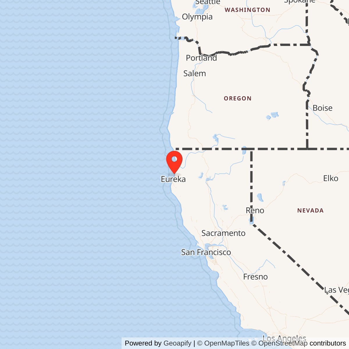
Longitude: -124.107222
Current Role: Active county-owned California Redwood Coast-Humboldt County Airport (KACV), Humboldt County's regional commercial airport, with general aviation and active Coast Guard Air Station Humboldt Bay operations on the reused airfield landscape. The principal former-defense FUDS remediation program is closed.
Airport ICAO ID: KACV
Naval Auxiliary Air Station Arcata was the World War II Navy heavier-than-air installation at the airfield now known as California Redwood Coast-Humboldt County Airport. Commissioned on 1943-07-07 as an auxiliary of Naval Air Station Alameda, it supported fleet aviation training, utility flying, forward-firing rocket instruction, aircraft maintenance, and experiments intended to make flight operations possible in the dense coastal fog that frequently covered the field. Its military importance came from a combination that was unusual even among naval auxiliary stations: it trained aircrews for war while simultaneously becoming a laboratory for technologies intended to defeat one of aviation's oldest operational hazards.
The name Arcata can obscure the station's actual geography. The airfield stood at Dows Prairie near McKinleyville, several miles north of the city of Arcata and well north of Eureka. It must not be confused with Naval Auxiliary Air Facility Eureka, the lighter-than-air blimp field on the Samoa Peninsula, with the Humboldt Bay Navy Section Base at the Samoa waterfront, or with Murray Field east of Eureka. Each was a separate military installation or property serving a different part of the wartime coastal-defense system.
The site also has a distinct post-Navy identity. After the Navy disestablished the auxiliary air station on 1946-05-01, the airfield continued as the Landing Aids Experiment Station, a joint military-civil research facility associated with the Navy, the emerging independent Air Force, and the Civil Aeronautics Administration. The experiment station tested fog dispersal, instrument landing, ground-controlled approach, airfield lighting, meteorology, and other methods for low-visibility operation. These activities continued after the naval station itself ceased to exist, so the 1946 disestablishment date must not be treated as the end of federal aviation work at Arcata.
The modern Coast Guard presence is another separate layer. Coast Guard Air Station Humboldt Bay was commissioned at the airport in 1977 and remains an active aviation command there. It shares the broader airfield landscape but is not a continuation, redesignation, or direct organizational successor of NAAS Arcata. The permanent Navy and Coast Guard installation identifiers should therefore remain separate even though both installations share the same physical site history and the same site_uid in the inventory.
Geographic Setting and Site Selection
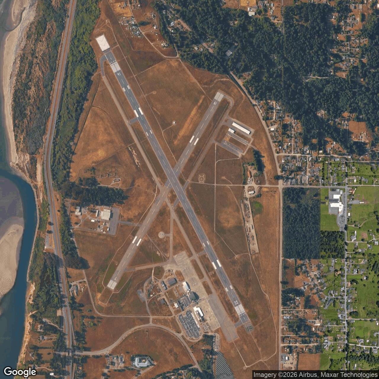
The airfield lies on a coastal terrace between U.S. Highway 101 and the Pacific Ocean. This location gave aircraft immediate access to coastal operating areas and placed the field near the sea lanes, military installations, and communities of Humboldt County. It also exposed the airfield to the marine layer generated where cold Pacific water, coastal winds, and local terrain create persistent low cloud and fog. The condition that made the site difficult for ordinary flying ultimately became one of the principal reasons the government retained it for research.A station history prepared by an officer at Arcata in 1945 traced the property to land formerly owned by Arthur Hoover. Part of the tract had been used as a private airport while the rest supported seed-potato agriculture. Humboldt County acquired the property and leased it to the United States government on 1942-06-25, with a stated maximum lease period extending to 1967-06-30. The arrangement illustrates the mixed local-federal character of the wartime project: the county supplied land while the federal government rapidly converted it into a military airfield.
That same 1945 account states that the U.S. Army constructed the runways and completed them late in 1942. In early 1943 the Army ended its operations at the field and transferred use to the Navy, which then built the housing, administrative, maintenance, and operational facilities needed for an auxiliary air station. This Army construction phase is historically important, but no source establishes a separately commissioned Army installation name or a long-lived independent Army garrison at Dows Prairie. The evidence supports treating it as a precursor construction and use phase of the later Navy airfield rather than creating a separate Army master row without stronger documentation.
The acreage record contains an unresolved internal conflict that should be preserved rather than silently corrected. The officer-prepared 1945 history calls the air base a 668-acre installation, but in the same passage states that 325 acres were federal property and 442 acres were county property. Those two component figures total 767 acres, not 668. A modern environmental account describes a 676-acre former defense site.
Construction and Physical Development
The Army-built runway system gave the Navy a developed flight field rather than an unimproved landing strip. Secondary station research identifies two principal asphalt runways, one approximately 6,000 feet long and another approximately 4,500 feet long. A third runway was contemplated but not completed. U.S. Highway 101 had to be relocated during airfield development, an indication of how substantially the wartime project altered the existing rural landscape.Once the Navy assumed control in 1943, construction expanded beyond the runways. The station required barracks, officers' quarters, administration, maintenance facilities, aviation shops, utilities, fuel storage, communications, roads, parking aprons, security, and a hangar complex. Published station research identifies a 128-by-160-foot Kodiak-type hangar and defensive gun emplacements around the field. These facilities transformed what had been a rural and partly agricultural property into a self-contained naval aviation station capable of supporting hundreds of personnel and visiting squadrons.
Personnel figures from March 1944 demonstrate the scale of the station. Secondary research based on wartime Navy records reports 153 officers and 532 enlisted personnel at Arcata, with barracks capacity for approximately 180 officers and 732 enlisted members. These numbers are not necessarily the station's wartime peak, but they show that Arcata was considerably more than a remote landing strip. It had the manpower and physical plant needed to support fleet training, aircraft servicing, range operations, and a growing technical research mission.
The station also maintained its own aircraft for administrative and support work. Published records identify two Howard GH ambulance aircraft and a Beech GB Staggerwing among the station planes. Utility Squadron VJ-2 brought a more varied aircraft mix when it arrived in late 1943, including Avengers, Martin JM aircraft, a J2F Duck, and an R50 transport. Visiting and training organizations brought still other types, including SBD Dauntless dive bombers, F6F Hellcats, FM-2 Wildcats, and patrol bombers.
Commissioning and Early Navy Mission
Naval Auxiliary Air Station Arcata was commissioned on 1943-07-07 under Naval Air Station Alameda. The relationship to Alameda placed the North Coast field inside the Twelfth Naval District's large wartime aviation network. Alameda was a major fleet air station and logistics center, while auxiliary stations distributed training and operational activity to less congested airfields. Arcata's distance from the San Francisco Bay area made it useful for specialized training that required open airspace, nearby coastal ranges, and separation from heavier traffic.The Navy initially envisioned greater patrol-aircraft use than the weather ultimately allowed. Secondary station research states that planning contemplated as many as twenty-four Ventura patrol bombers. Persistent fog restricted the field's ability to sustain that level of normal operations. Rather than making the installation useless, the weather pushed Arcata toward missions that could exploit its coastal location while also turning the fog itself into a research asset.
Utility Squadron VJ-2 became the first major operational organization identified at the station, arriving in December 1943. The squadron's mixed aircraft supported utility flying, target work, communications, and training functions rather than a single combat-aircraft syllabus. In the summer of 1944, Scouting Squadron 71 operated eleven SBD Dauntless aircraft at Arcata. These assignments show the station's changing use as the Navy adapted the field to the weather, training demand, and needs of fleet aviation organizations based elsewhere.
Arcata was therefore not a patrol base in the same sense as a permanent patrol-wing station. It functioned as an auxiliary field where units or detachments could receive specialized instruction and make use of coastal ranges. Its value increased when the Navy began emphasizing forward-firing aircraft rockets, a weapon that required pilots to learn attack geometry, aiming, range estimation, and firing techniques before they could employ rockets effectively in combat.
Forward-Firing Rocket Training
About 1944-04-01, Fleet Air Alameda designated Arcata as a training station for forward rocket firing. An officer-prepared wartime history states that personnel were sent to install targets and organize the training program. The choice of Arcata took advantage of the relatively open coast and the ability to create remote target areas away from dense urban development. Rocket training became one of the installation's most intensive wartime missions.The first major rocket target was established at Big Lagoon north of the air station and was completed in December 1944. A second target on the south spit of Humboldt Bay was also operating by December 1944. These detached target areas expanded the effective military footprint far beyond the air-station boundary. Aircraft could launch from Arcata, fly to the coastal target areas, make repeated firing runs, and return to the station for refueling, maintenance, ammunition servicing, and debriefing.
The rocket program accelerated sharply from September 1944 through June 1945. Combat Aircraft Service Unit 36 at Santa Rosa supplied a detachment that supported the training, while squadrons and air groups cycled through Arcata for practice. Published station research records a changing mix of F6F Hellcats, FM-2 Wildcats, SBD Dauntlesses, and TBF/TBM Avengers associated with the training system. The specific aircraft complement varied over time because Arcata served transient fleet units rather than one permanently assigned combat squadron.
The training had a direct connection to Pacific combat operations. The official Navy squadron history for VPB-153 states that while based at Naval Air Station Moffett Field from November 1944 into March 1945, the squadron conducted rocket training at NAAS Arcata and Naval Air Facility Fallon while preparing for overseas deployment. It transitioned to PV-2 Harpoons, moved to Hawaii in March and April 1945, and then deployed to Agana, Guam, where it flew wartime patrol missions. Arcata's contribution was therefore precombat training rather than direct participation in battle, but the skills practiced there accompanied operational units into the Pacific war.
Other carrier and fleet aviation organizations also used Arcata during training cycles. Official Navy records for later strike-fighter squadron lineages note reforming and training periods that included operations from Arcata among other West Coast auxiliary fields. This networked use is more historically accurate than treating every transient squadron as permanently assigned. The station supplied facilities, ranges, maintenance, and specialized instruction while the squadrons remained organizationally tied to their home stations and fleet commands.
By mid-1945, however, the rocket mission began competing physically with the expanding landing-aids work around the runways. The officer-prepared station history states that by approximately 1945-06-01 experimental landing-aids activity was concentrated close enough to the flight surfaces to interfere with rocket training. On 1945-07-01 the fleet withdrew its rocket-training personnel, stripped the targets, and removed squadron and fleet personnel. The installation's center of gravity had shifted from combat preparation toward aviation research.
Fog as an Operational Problem
Arcata's fog was not a minor inconvenience. Low ceilings and poor visibility could suspend ordinary visual operations for extended periods, making a station intended for fleet training unreliable unless crews had adequate instruments and landing aids. World War II aviation still depended heavily on visual references during approach and landing, so a field that repeatedly disappeared under coastal fog posed a serious readiness problem.The Navy turned that disadvantage into a research opportunity. Arcata's recurring low-visibility conditions created a natural laboratory where engineers and pilots could test systems repeatedly under real fog rather than waiting for occasional weather at a more favorable station. The field eventually became associated with an unusually broad collection of aids, including instrument landing equipment, ground-controlled approach radar, high-intensity and experimental lighting, meteorological instrumentation, visibility measurement, and thermal fog dispersal.
The most dramatic system was FIDO, the Fog Investigation and Dispersal Operation. Fuel was burned in lines of equipment bordering the runways to produce enough heat to lift or thin the fog over the landing surface. The process was spectacular and extremely fuel intensive. A modern engineering account reports consumption near 100,000 gallons per hour, illustrating why FIDO could be valuable as an emergency or experimental method while remaining difficult to justify as a routine national solution.
The Bureau of Aeronautics formally accepted Arcata as a FIDO installation on 1945-01-01. On 1945-02-15 a Seabee detachment of two officers and ninety-two enlisted ratings was ordered to the station for construction, installation, and operation of the system. This was a substantial technical deployment, not a small laboratory demonstration. It required fuel handling, piping, burners, electrical and control systems, maintenance, safety planning, and coordination with normal flight operations.
The FIDO infrastructure eventually became one of the installation's largest physical systems. Later engineering records identify approximately 40,000 feet of buried and exposed distribution piping along the runways and another roughly 2,000 feet of buried supply line connecting the airfield to a rail unloading point across Highway 101. That system fed a tank farm containing six 50,000-gallon aboveground tanks. The scale of the fuel network explains both the technical ambition of the experiment and its later environmental legacy.
Transition from War to Research
Japan's surrender removed much of the urgency behind Arcata's combat-training mission. The Navy considered decommissioning the station, but its value for low-visibility research remained. The officer-prepared history records a decision to reduce Arcata to functional status on 1945-09-15 so that the station could continue supporting the FIDO detachment and broader landing-aids experimentation after fleet training had largely departed.This functional status marked a clear mission transition. Arcata was no longer primarily a place where fleet squadrons prepared for immediate wartime operations. It was becoming a government research airfield where pilots, engineers, meteorologists, technicians, military services, civilian regulators, airlines, and contractors could evaluate how aircraft should approach and land when the runway could not be seen. The question was broader than FIDO and would ultimately help shape national instrument-flight procedures and airport technology.
The Navy formally disestablished NAAS Arcata on 1946-05-01. Later Naval Aeronautical Organization listings preserve that date for Arcata among inactive or disestablished aviation shore establishments. The disestablishment ended the commissioned naval auxiliary air station, but federal work at the field continued under the Landing Aids Experiment Station identity. This distinction reconciles sources that refer to Navy closure in 1946 with later accounts describing government experimentation through the late 1940s.
The postwar experiment was joint by design. Modern engineering documentation describes the Landing Aids Experiment Station as a Navy, U.S. Air Force, and Civil Aeronautics Administration project coordinated by the Navy's Bureau of Aeronautics. The institutional labels changed as the Army Air Forces became the independent Air Force in 1947, but the central purpose remained the same: compare technologies and operating procedures that could allow safe flight in conditions that had previously closed an airport.
Landing Aids Experiment Station
The Landing Aids Experiment Station became one of the country's most important low-visibility aviation laboratories. Research extended well beyond fog burning. Investigators studied ground-controlled approach radar, instrument landing systems, airfield lighting, meteorology, transmissometers and visibility measurement, approach geometry, pilot procedures, and the interaction among several aids used at the same time. The station's poor weather provided repeated real-world test conditions that laboratories and fair-weather airports could not duplicate.Civil aviation became increasingly important to the program. On 1947-09-16 local reporting announced Civil Aeronautics Administration approval for scheduled airline use of the integrated landing system at Arcata under specified weather minimums. Southwest Airways then used the field not merely as an experimental location but as a proving ground for techniques intended to make scheduled commercial service more reliable in weather that would otherwise force cancellation or diversion.
On the morning of 1947-12-14, a Southwest Airways Douglas DC-3 made what the airline's 1947 annual report described as the world's first scheduled commercial airline blind landing at Eureka-Arcata. The aircraft used the combination of ground-controlled approach, instrument landing equipment, and FIDO to descend through dense fog. The event connected a former wartime military research mission directly to the emerging postwar commercial aviation system.
The significance was not that FIDO itself became universal. Its enormous fuel consumption, operational complexity, and runway limitations made widespread adoption impractical. The more durable legacy came from comparing systems and developing combinations of radar, instruments, lighting, meteorological measurement, and standardized procedures. Later technical literature credits testing at Arcata with helping resolve questions about approach-lighting configurations and other elements of low-visibility operations.
The Civil Aeronautics Administration assumed administrative control of the Landing Aids Experimental Station on 1948-04-01. The FAA historical chronology describes the site at that point as a joint civil-military, government-industry facility concerned primarily with testing equipment and techniques for bad-weather landings. The transfer of administrative control did not erase military participation. It reflected the fact that technologies developed for wartime necessity were becoming central to the safety and reliability of the national civil air system.
Final reports issued in 1949 document the breadth of the research. Their subjects included flight operations, meteorology, electronics, airfield lighting, and fog dispersal. The experiment station was winding down by the end of the decade, and secondary station history places its closure in 1950. Rather than assigning an unsupported day-level closure, the history treats 1949 as the final major reporting year, 1950 as the secondary-source operational end, and 1956 as the much later legal transfer of the former federal property to Humboldt County.
Facilities and Technical Infrastructure
Arcata's wartime cantonment supported both ordinary naval aviation and unusual experimental work. Barracks and officers' quarters housed the station population, while administrative buildings, shops, hangars, aprons, fuel systems, roads, communications, and security supported daily flying. The dispersed target ranges at Big Lagoon and the Humboldt Bay south spit were operational extensions rather than part of the central airfield acreage.The experimental phase overlaid additional infrastructure on the runway system. FIDO required long burner lines and supply piping, bulk fuel tanks, pumping and control equipment, and a rail-connected fuel-delivery system. Ground-controlled approach radar required carefully sited equipment and trained controllers. Instrument landing transmitters, approach lights, meteorological instruments, and visibility-measuring equipment occupied still other positions around the flight surfaces. The resulting airfield was both an operating airport and a full-scale aviation laboratory.
That physical overlap explains the 1945 conflict between rocket training and landing-aids research. Rocket operations required unrestricted aircraft movement and access to armed training aircraft, while experiments required equipment close to the runway environment and repeated controlled approaches. The Navy solved the conflict by ending the fleet rocket-training program at Arcata and concentrating on the technical mission. This was an operational decision driven by competing uses of the same finite airfield rather than a simple postwar shutdown.
The technical plant also created a long-lived environmental problem. FIDO's enormous fuel demand meant that petroleum was stored and moved through miles of piping, some buried and some exposed. When the experimental program ended, portions of the network remained beneath the airfield. Later airport construction, utility changes, and incomplete as-built documentation made the exact system difficult to locate, turning a wartime research asset into a complex remediation challenge decades later.
Units and Organizations
Naval Air Station Alameda was Arcata's principal parent station during the commissioned Navy period. Fleet Air Alameda designated Arcata for forward rocket-firing training and supplied the command framework within which the auxiliary field served visiting units. The Twelfth Naval District provided the wider regional shore establishment, while Bureau of Aeronautics authority became increasingly important as the fog-dispersal and landing-aids mission expanded.VJ-2 was the earliest major operational squadron identified at the field, arriving in late 1943 with a mixed utility aircraft complement. Scouting Squadron 71 operated at Arcata during 1944, and Combat Aircraft Service Unit 36 supplied the support detachment associated with rocket training. These organizations represent different kinds of Navy presence: an operational utility squadron, a combat-type flying squadron, and a service unit responsible for maintaining and supporting training aircraft and range activity.
VPB-153 provides the clearest documented link between Arcata training and subsequent combat. The squadron conducted rocket training at Arcata while preparing for Pacific deployment, then moved through Hawaii to Guam and began wartime patrol operations there in June 1945. Arcata did not deploy as a unit and no battle occurred at the station, but its ranges contributed directly to the readiness of a squadron that entered an active combat theater.
The FIDO mission brought a different organizational community. A Seabee detachment constructed and operated major portions of the fog-dispersal system, while Bureau of Aeronautics technical organizations coordinated the experimental program. Postwar partners included the Army Air Forces and later U.S. Air Force, Civil Aeronautics Administration, airlines, contractors, scientists, engineers, and pilots. By the late 1940s the site's most important "unit" was effectively a joint research enterprise rather than a conventional naval squadron.
Relationship to the Eureka Naval Defense Complex
Arcata operated within a dense network of military properties around Humboldt Bay. The Navy Section Base at Samoa coordinated local naval defense and waterfront functions. NAAF Eureka on the Samoa Peninsula supported lighter-than-air patrol operations. The Army used Murray Field for an earlier antisubmarine patrol role. Coast Guard Station Humboldt Bay provided surf and lifesaving capability. Arcata added heavier-than-air aviation, training, and eventually experimental landing-aids capability.Humboldt County's modern World War II memorial page states that the airport functioned as headquarters for the Eureka section of local naval defense forces. That wording is important local historical evidence, but it conflicts with Navy filing and property evidence that supports a separate Humboldt Bay Section Base at the Samoa waterfront. Without a documented headquarters transfer or clear contemporary command order, the safer interpretation is that Arcata supported the Eureka naval-defense system without collapsing the separate section-base property into the air station.
The distinction matters because the Humboldt Bay military complex used multiple geographically separated sites to solve different problems. Waterfront command, seaplane operations, airship patrols, Army aviation, surface rescue, and heavier-than-air training could not all be performed efficiently from one tract. Arcata's place in the system was aviation-specific, and its later landing-aids role became even more specialized.
Environmental History and FUDS
The former air station entered the Formerly Used Defense Sites program because military use left potential environmental and munitions issues. The U.S. Army Corps of Engineers inventory identifies the property as Naval Auxiliary Air Station Arcata, project J09CA0799, with CON/HTRW, HTRW, and MMRP project categories. Those categories reflected concerns involving containerized hazardous or toxic waste, broader hazardous or toxic waste, and potential munitions-response issues.FIDO became the most persistent environmental problem. The miles of fuel piping and large tank farm created locations where residual petroleum and associated waste could remain after the system was abandoned. Cleanup began in 1995 with removal of some underground storage tanks and a limited section of piping, followed by additional tank removal and groundwater monitoring through 2006. Later investigation showed that original design drawings did not always match what crews encountered beneath the active airport.
A renewed seven-year remediation program investigated and removed the remaining FIDO system. Engineering teams used soil and groundwater sampling, geophysical work, ground-penetrating radar, video inspection, and field screening to locate and characterize buried infrastructure. Crews inspected roughly 35,000 feet of pipeline, removed petroleum-impacted soil and pipe, and recovered or flushed residual liquids while coordinating work around active runways, utilities, Coast Guard operations, and airport traffic.
The project removed approximately 45,000 gallons of nonhazardous liquid waste and more than 2,800 gallons of hazardous liquid waste. Work often occurred at night or during off-peak airport periods because excavations could be only feet from active flight surfaces. The project also had to account for sensitive habitat and cultural-resource concerns. The combination of environmental engineering and airfield coordination illustrates how difficult it can be to remediate a former military installation that has never stopped functioning as an airport.
The remediation reached No Further Action/Case Closure in June 2025. A 2026 Society of American Military Engineers account reports that the former base is no longer listed for cleanup as a FUDS site following the completed program.
Transfer and Civil Reuse
The federal-to-county transfer also requires correction from simplified secondary accounts. Some older histories state that the government gave the airfield to Humboldt County by about 1950. Modern engineering research tied to the property records states that the former NAAS property was transferred to Humboldt County by quitclaim deed in 1956. The earlier date appears to describe the end of the experiment-station operating period or a transition to county use rather than the final legal conveyance.Humboldt County developed the former military field into the regional airport now formally called California Redwood Coast-Humboldt County Airport. The original military runway plan, coastal location, and instrument-flying legacy made the property especially valuable for civilian aviation in a region where terrain and weather can complicate access. Over time, commercial passenger service, general aviation, emergency response, and federal Coast Guard operations replaced the wartime training mission.
The field's low-visibility research legacy remains especially appropriate to its current role. Humboldt County describes KACV as having the most capable instrument approach among its six airports. That modern capability is not simply the original World War II equipment surviving in place, but it continues the operational problem the Navy and postwar researchers tried to solve: maintaining reliable access to a remote coastal community when fog obscures the runway.
Current Status
California Redwood Coast-Humboldt County Airport remains an active county-owned commercial-service airport in 2026. Humboldt County identifies it as the county's sole regional commercial airport, certificated under federal commercial-airport and security requirements. Scheduled airlines currently connect the field with major western destinations, and Alaska Airlines began new nonstop Seattle service in April 2026. General aviation, medical flights, emergency response, and other aviation uses operate alongside commercial traffic.Coast Guard Air Station Humboldt Bay occupies part of the airport and conducts helicopter search and rescue from the shared airfield landscape. County planning documents identify the Coast Guard air station within ACV property and describe its use of airport facilities.
The old naval station is therefore neither an abandoned base nor an active Navy installation. It is a former military airfield whose core aviation function survived through civilian reuse. Some military-era buildings and infrastructure survived for varying periods, but redevelopment, airport modernization, Coast Guard construction, and environmental remediation have substantially altered the wartime physical plant. Any surviving structure should be tied to documentary evidence before being identified as an original Navy building.
The environmental record has also reached a new stage. The June 2025 No Further Action/Case Closure means that the FUDS cleanup program described in older planning documents should no longer be characterized as an open remediation effort.
Chronology
- 1942-06-25 Humboldt County leased the Dows Prairie airfield property to the United States government under an agreement that could extend to 1967-06-30.
- Late 1942 The U.S. Army completed the principal runways at the future Arcata naval airfield.
- Early 1943 The Army ended operations at the field and turned use over to the Navy, which expanded housing, administration, maintenance, and aviation facilities.
- 1943-07-07 Naval Auxiliary Air Station Arcata was commissioned as an auxiliary of Naval Air Station Alameda.
- 1943-12 Utility Squadron VJ-2 arrived as the first major operational squadron identified at the station.
- 1944-03 Published station records listed approximately 153 officers and 532 enlisted personnel at Arcata.
- 1944-04-01 Fleet Air Alameda designated Arcata as a forward-firing rocket training station and began developing the range program.
- Summer 1944 Scouting Squadron 71 operated eleven SBD Dauntless aircraft at Arcata.
- 1944-09 Rocket training entered a period of greatly accelerated activity that continued into June 1945.
- 1944-12 The first rocket target at Big Lagoon was completed.
- 1944-12 A second rocket target on the south spit of Humboldt Bay entered operation.
- 1944-11 to 1945-03 VPB-153 trained with rockets at Arcata while preparing for Pacific deployment.
- 1945-01-01 The Bureau of Aeronautics accepted Arcata as a FIDO installation.
- 1945-02-15 A Seabee detachment of two officers and ninety-two enlisted ratings was ordered to Arcata for FIDO construction, installation, and operation.
- 1945-03-24 VPB-153 began movement from the West Coast toward Hawaii after completing its stateside training cycle.
- 1945-06 Landing-aids activity near the runways increasingly conflicted with the rocket-training mission.
- 1945-06-20 VPB-153, which had trained at Arcata, began wartime patrol operations from Guam.
- 1945-07-01 Fleet rocket-training activity withdrew from Arcata, targets were stripped, and squadron and fleet personnel were removed.
- 1945-08 Following victory over Japan, the Navy considered decommissioning Arcata but retained the field for landing-aids research.
- 1945-09-15 Arcata was reduced to functional status to support FIDO and landing-aids experimentation.
- 1946-05-01 The Navy disestablished Naval Auxiliary Air Station Arcata.
- 1946 The former naval field continued in federal use as the Landing Aids Experiment Station.
- 1947-09-16 Local reporting announced Civil Aeronautics Administration approval for scheduled airline use of the integrated landing system at Arcata under specified weather minimums.
- 1947-12-14 A Southwest Airways DC-3 completed the world's first scheduled commercial airline blind landing using the integrated Arcata landing-aids system.
- 1948-04-01 The Civil Aeronautics Administration assumed administrative control of the Landing Aids Experimental Station.
- 1948 Southwest Airways accumulated extensive routine instrument operations at Arcata, demonstrating practical commercial use of the experimental landing-aids environment.
- 1949 The Air Force-Navy-Civil Landing Aids Experiment Station issued final reports covering flight operations, meteorology, electronics, airfield lighting, and fog dispersal.
- 1950 Secondary station history places the operational closure of the Landing Aids Experiment Station in this year.
- 1956 The former NAAS Arcata property was transferred to Humboldt County by quitclaim deed.
- 1977-06-24 Coast Guard Air Station Humboldt Bay was commissioned at the former Arcata naval-airfield site as a separate Coast Guard installation.
- Mid-1980s The former Navy property entered the Formerly Used Defense Sites program.
- 1995 Environmental cleanup work began with removal of underground storage tanks and portions of FIDO piping.
- 1995 to 2006 Tank removal and groundwater-monitoring work addressed parts of the former FIDO fuel system.
- 2016 to 2018 USACE and airport stakeholders developed the approach for investigation and remediation of remaining FIDO infrastructure.
- 2018 to 2025 A seven-year remediation effort characterized, cleaned, removed, or flushed remaining FIDO system components and associated contamination.
- 2025-06 The former NAAS Arcata FUDS cleanup reached No Further Action/Case Closure.
- 2026-04-08 New daily Alaska Airlines service from KACV to Seattle-Tacoma began, illustrating continued regional commercial use of the former military field.
- 2026 California Redwood Coast-Humboldt County Airport remains active as Humboldt County's regional commercial airport with Coast Guard Air Station Humboldt Bay operating on part of the airfield.
- Present The former NAAS Arcata landscape remains in active aviation use, while the Navy installation itself is closed and the principal FUDS remediation program has achieved case closure.
Sources & References
- WEB Cal Poly Humboldt Special Collections, "History of Naval Auxiliary Air Base At Arcata Prepared by Officer at Station" Source for the 1942 county lease, Army runway construction, early 1943 Navy transfer, reported acreage, and Navy facility-development context.
- WEB Cal Poly Humboldt Special Collections, "Development of Rocket Target Practice At NAAS Near Arcata Told In Hist. of Base" Source for the 1944 designation as a forward-firing rocket training station, Big Lagoon and Humboldt Bay targets, and the accelerated 1944-1945 rocket-training program.
- WEB Cal Poly Humboldt Special Collections, "Here's Final Chapter On History Of Naval Air Station At Arcata" Source for Bureau of Aeronautics FIDO acceptance, the Seabee detachment, conflict between rocket training and landing-aids research, and 1945 functional-status reduction.
- PDF Naval History and Heritage Command, Naval Aeronautical Organization inactive and disestablished shore-establishment listings Source for the official 1946-05-01 disestablishment date for NAAS Arcata.
- PDF Naval History and Heritage Command, Dictionary of American Naval Aviation Squadrons, VPB-153 history Source for VPB-153 rocket training at Arcata and the squadron's subsequent Pacific deployment and wartime patrol operations.
- PDF Naval History and Heritage Command, Dictionary of American Naval Aviation Squadrons, strike fighter squadron histories Source for fleet squadron reforming and training cycles that included operations from NAAS Arcata.
- PDF U.S. Department of Transportation, FAA Historical Chronology, 1926-1996 Source for the Civil Aeronautics Administration's 1948-04-01 assumption of administrative control of the Landing Aids Experimental Station and the joint civil-military research mission.
- WEB Air Force-Navy-Civil Landing Aids Experiment Station, Arcata, Final Reports Source for the 1949 final research program covering flight operations, meteorology, electronics, airfield lighting, and fog dispersal.
- WEB Southwest Airways, Annual Report 1947, Digital Library of Georgia Source for Southwest Airways' first commercial airline use of FIDO and the 1947-12-14 scheduled blind landing at Eureka-Arcata.
- WEB Cal Poly Humboldt Special Collections, Southwest Airways CAA landing-system approval Source for the 1947-09-16 announcement of Civil Aeronautics Administration approval for scheduled airline use of the integrated Arcata landing system.
- WEB Society of American Military Engineers, "Clearing the Fog: Path to Environmental Recovery at NAAS Arcata" Source for FIDO infrastructure, 1956 quitclaim transfer, modern remediation quantities, the seven-year cleanup program, and June 2025 No Further Action/Case Closure.
- PDF U.S. Army Corps of Engineers, FUDS Inventory California Source for former NAAS Arcata FUDS property J09CA0799 and its CON/HTRW, HTRW, and MMRP project categories.
- WEB Humboldt County, California Redwood Coast-Humboldt County Airport Source for current KACV identity, county ownership and operation, commercial service, current address, general aviation, and Coast Guard presence.
- WEB Humboldt County Airport Land Use Compatibility Plan Source for the airport's McKinleyville location, relationship to Arcata, and current Coast Guard Air Station location within the ACV airport property.
- WEB Humboldt County, World War II Memorial at ACV Source for current public interpretation of the airport's World War II Navy history and surviving local historical memory.
- WEB Humboldt County, "Daily Service from ACV to Seattle-Tacoma Coming April 2026" Source for current commercial-airport activity and the 2026 Seattle service.
- WEB California State Military Museum, "Naval Auxiliary Air Station, Arcata" Secondary source for commissioning, aircraft, unit, runway, facility, personnel, and postwar research details compiled from Navy-era records.
- PDF Federal Aviation Administration research bibliography and low-visibility studies Source for Landing Aids Experiment Station reports and the continuing technical record of Arcata low-visibility research.
- WEB Humboldt County, 2026 ACV Taxiway A project addendum Source for continuing 2026 capital improvement activity at the current airport and current environmental due-diligence information.
- WEB TIME, "Aviation: Small-Town Big-Timer," 1948 Contemporary national account of Arcata's low-visibility aviation experiments and Southwest Airways instrument operations.