
Naval Auxiliary Landing Field Crows Landing, California
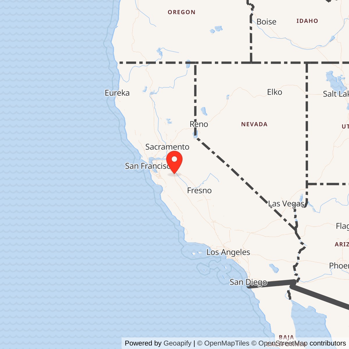
Longitude: -121.10964203
Current Role: Former Navy/NASA airfield now in Stanislaus County reuse as the Crows Landing Industrial Business Park and Airfield / The Landing; planned public-use airport and industrial/logistics redevelopment; former runways and airfield infrastructure remain central to reuse; Navy BRAC environmental closeout work continues for the administrative area groundwater plume.
Crows Landing was one of those places the Navy needed precisely because it was not on the coast. The flight line sat in open Central Valley farm country, far enough from San Francisco Bay congestion to let young naval aviators make repeated approaches, landings, carrier-pattern turns, night approaches, and later jet practice without fighting the traffic, weather, and urban pressure surrounding the Bay Area's main naval air stations. It began as a wartime auxiliary field for Alameda and then lived a second, longer life as an outlying training and research-support field for Moffett Field, NASA Ames, and other federal users.
The installation's official identity shifted over time. It was developed in late 1942 and commissioned in May 1943 as Naval Auxiliary Landing Field Crows Landing. Some wartime and later historical sources also use the Naval Auxiliary Air Station form, reflecting its more substantial World War II station facilities. After World War II it was deactivated, then reactivated in 1950 during the Korean War as a Naval Auxiliary Landing Field. In July 1994, after the BRAC closure of NAS Moffett Field, Crows Landing was retained as a federal facility for NASA and renamed NASA Crows Landing Flight Facility. It later passed into Stanislaus County reuse planning and is now the site of the Crows Landing Industrial Business Park and Airfield, also branded locally as The Landing.
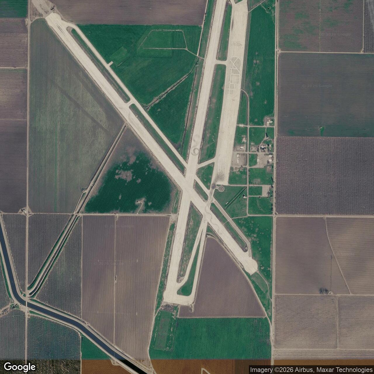
Crows Landing should therefore be understood as a former Navy auxiliary aviation installation, not merely a runway or practice strip. It had a wartime training mission, a Cold War field-carrier-landing-practice mission, refueling and rearming support, air traffic control, communications, crash and rescue functions, security, limited troop support facilities, and later NASA research-flight functions. It covered roughly 1,520 to 1,528 acres depending on source and counting convention, with two long concrete runways forming the durable core of the site.
Mission Evolution
The Navy selected the Crows Landing area during the rapid expansion of West Coast naval aviation in World War II. NAS Alameda was a major carrier-aircraft and fleet-support station, but its Bay Area location could not absorb every stage of flight training. The solution was an inland auxiliary field with good weather, open approaches, and enough land for long runways and support facilities. Crows Landing began operating in late 1942 as an auxiliary air station to Alameda and was commissioned in May 1943.The first mission was wartime training. Crows Landing supported Fleet Air Units of the Twelfth Naval District and helped relieve pressure on Alameda by giving carrier and multi-engine crews a separate field for intensive practice. Fighter and torpedo-bomber pilots could train away from the main station; transport and patrol crews later used the long concrete runways for heavier aircraft. The site's wartime role made it part of a wider California network that included other Alameda-associated fields such as Santa Rosa, Vernalis, Watsonville, and Hollister.
By 1946 the wartime base had been deactivated. The Korean War brought it back. In 1950 the Navy reactivated Crows Landing as a Naval Auxiliary Landing Field. The new mission was no longer just World War II pilot throughput. It was field carrier landing practice, refueling, rearming support for ordnance training, and relief capacity for Moffett Field and Alameda during the jet age. Navy historical survey material records that Crows Landing received additional construction in the early and late 1950s, including runway extension work, a control tower, radio facilities, a portable Mirror Landing system, aviation fuel facilities, TACAN, public works and storage sheds, simulated carrier decks, runway deck lights, and arresting gear.
That Cold War mission grew directly out of congestion at Moffett Field. As jet aircraft activity increased at Moffett and development expanded around the airfield, one difficult mission was repeated low-altitude approach practice to a simulated carrier deck. Crows Landing's isolation made it better suited to that training. NASA's Cold War-era historical resources report states that the activity was transferred to Crows Landing in 1954. Beginning in 1955, Crows Landing operated 12 hours a day for night Fleet Carrier Landing Practice, and the peak came in 1960, when mirror-landing practice was conducted up to 20 hours per day.
After NAS Lemoore opened in 1961 and took over much of the Navy's more isolated jet mission in the Central Valley, Crows Landing began to decline as a heavily manned field. It continued to support jet landing practice, but by the mid-1960s personnel and civilian labor were reduced, the administration building closed, and the barracks and mess hall were demolished. The field survived because it was still useful as an outlying runway complex, but it no longer carried the same station-like population and support footprint that it had during World War II and the Korean War buildup.
The final federal aviation era came through NASA and Moffett. The Navy BRAC office states that Crows Landing served operations from NAS Moffett Field and other Navy facilities, as well as other federal and state agencies, including NASA Ames Research Center at Moffett Field. When NAS Moffett Field closed under BRAC, Crows Landing was retained for NASA in July 1994 and renamed NASA Crows Landing Flight Facility. A 1995 Federal Register rule added Crows Landing Airport to NASA's list of airfield facilities and described the airfield as part of the Crows Landing Flight Facility.
Operational Role
Crows Landing's operational value was repetition. Carrier aviation is built on approach discipline, landing pattern habit, night approach confidence, and the ability to perform difficult maneuvers without hesitation. Main naval air stations were crowded with squadrons, maintenance, logistics, transport, and command activity. An outlying field gave pilots a place to do the same demanding tasks again and again, away from the main base.During World War II, Crows Landing helped the Navy expand training capacity for carrier-related and multi-engine aircraft. Its open terrain and long concrete runways made it especially valuable when heavier aircraft needed more forgiving space than shorter or less-developed auxiliary fields could provide. At its wartime peak, NASA historical survey material states that the base housed 345 officers and more than 2,000 enlisted personnel. Those figures show that Crows Landing was not just a rural emergency strip. It was a functioning wartime aviation station with a sizeable military population.
In the Korean War and early Cold War, the operational role became more specialized. The field supported field carrier landing practice and ordnance-related aviation support, with facilities for refueling, crash and rescue, communications, air traffic control, security, and limited barracks and mess services. The installation of a portable Mirror Landing system, simulated carrier decks, deck lights, and arresting gear turned the Central Valley runway complex into a land-based replica of some of the visual and procedural conditions associated with carrier aviation. That was the point: pilots could practice carrier-style approaches and landings without a carrier being available and without tying up the Bay Area's main airfields.
The Federal Register's 1995 description captures the post-Navy NASA-era airfield in practical terms. It listed two concrete runways, 35/17 and 30/12, both 200 feet wide, with runway 35/17 at 7,950 feet and runway 30/12 at 6,975 feet. It noted that hangars did not exist, that concrete parking ramp space was available under tower direction, and that the tower operated only when NASA-Ames research flying was scheduled. When the tower was not operating, the field was closed except for arranged federal use. That description reveals how far the field had shifted from its wartime station role: the runways still mattered, but the built-up station had become a limited-use federal airfield.
Facilities and Physical Layout
Crows Landing's physical layout was dominated by its two crossing concrete runways, broad taxiway system, ramps, and a compact administrative/support area. The site's value lay in runway length, unobstructed approaches, and separation from urban airfield congestion. The Navy BRAC office gives the former installation acreage as approximately 1,520 acres, while Stanislaus County describes the reuse project as 1,528 acres. Both figures point to the same reality: this was a large airfield property set in a mostly agricultural landscape.The World War II and early Cold War station had more support infrastructure than later visitors might assume from the abandoned runway landscape. NASA's Cold War-era historical resources report identifies barracks, mess, air traffic control, communications, crash and rescue, refueling, security, control-tower, radio, fuel, storage, public works, and carrier-practice-related improvements. At the height of the Cold War carrier-landing mission, the field had the specialized gear needed to replicate carrier-style landing conditions on land.
By the 1990s, however, Crows Landing was no longer a fully supported naval air station. The 1995 Federal Register rule described no available hangar space and tower operations only when NASA-Ames research flights were scheduled. That limited facility status helps explain why the post-closure reuse discussion focused on land, runways, industrial development, environmental cleanup, and possible public aviation rather than on reuse of a dense built-up naval station.
Role in the Wider Military Network
Crows Landing's meaning comes from the network around it. In World War II it was part of NAS Alameda's auxiliary aviation system. Alameda was the parent air station and fleet-support hub; Crows Landing was one of the inland fields that gave squadrons room to train. Similar auxiliary fields at Santa Rosa, Vernalis, Watsonville, Hollister, and other locations made the Bay Area naval aviation system larger than any single base.In the early Cold War it became a relief valve for Moffett Field and a training extension for carrier aviation. The Navy's jet and carrier-practice requirements exceeded what could comfortably be done at urbanizing Bay Area airfields. Crows Landing's open location made it useful precisely because it was remote. It allowed intensive landing practice, night operations, refueling, and support activity while reducing pressure on Moffett and Alameda.
It also connected military aviation to NASA. NASA Ames and Moffett used Crows Landing because the old Navy field had the runway geometry and controlled federal environment useful for research and special aviation activities. That NASA use did not erase the Navy story; it depended on the Navy's earlier decision to build a large, isolated airfield in the Central Valley.
Closure, Transfer, and Reuse
Crows Landing's late history followed the BRAC-era reshaping of Bay Area naval aviation. NAS Moffett Field closed under BRAC, and Crows Landing was retained as a federal facility for NASA in July 1994. The Navy BRAC office lists Crows Landing's BRAC year as 1991 and its closure date as July 30, 1994. The installation was then renamed NASA Crows Landing Flight Facility.Congress authorized transfer of the facility to Stanislaus County in October 1999. The Navy BRAC office states that a majority of the property was conveyed from NASA to Stanislaus County in September 2004 for unrestricted use and that all property at the former NALF Crows Landing has now been transferred. Environmental work remains significant. The Navy continues work on what it identifies as the administrative area groundwater plume, and the Navy states that once this site is closed, all environmental actions at Crows Landing will be complete.
Stanislaus County now presents the site as the Crows Landing Industrial Business Park and Airfield, or The Landing. The county describes it as a 1,528-acre reuse project on the former Crows Landing Air Facility, one mile from Interstate 5, with planned industrial, logistics, aviation, and employment uses. The county's current plan includes a 370-acre public-use airport element reusing Runway 12-30, with a planned runway length of approximately 5,175 feet and related taxiway, hangar, fueling, terminal, parking, and support facilities.
Current Status
Crows Landing is no longer an active Navy installation. It is a former BRAC Navy auxiliary landing field that has moved through NASA custody into county-led redevelopment. The site is owned and planned around Stanislaus County's Crows Landing Industrial Business Park and Airfield reuse program, while remaining environmental obligations continue under Navy oversight. The former runways and airfield geometry remain the defining physical traces of the military installation.
Chronology
- Late 1942 The Navy began developing and operating the Crows Landing area as an auxiliary airfield for NAS Alameda.
- 1943-05 Navy BRAC records identify the facility as commissioned in May 1943 as Naval Auxiliary Landing Field Crows Landing.
- 1943-05-25 Common detailed airfield histories identify this as the commissioning date for the Crows Landing naval auxiliary field.
- 1943-1945 Crows Landing supported Twelfth Naval District fleet air training during World War II.
- 1946 The base was deactivated after the wartime emergency ended.
- 1950 The Navy reactivated Crows Landing during the Korean War as Naval Auxiliary Landing Field.
- 1953 Additional Cold War construction included control, radio, and support improvements.
- 1954 Carrier-landing-practice activity moved from Moffett Field to Crows Landing because of congestion and development around Moffett.
- 1955 Crows Landing began operating 12 hours a day in support of night Fleet Carrier Landing Practice.
- 1958-1959 Aviation fuel, TACAN, storage, public works, and transportation support improvements were added.
- 1960 Mirror landing practice reached its peak intensity, with operations reported up to 20 hours per day.
- 1961 NAS Lemoore opened, drawing away the more isolated Central Valley jet mission.
- 1962 Simulated carrier decks, deck lighting, and arresting gear supported more realistic night carrier-landing practice.
- 1963-1965 Mess, barracks, and administrative support were reduced as activity declined.
- 1991 Crows Landing entered the BRAC closure framework.
- 1994-07 Crows Landing was retained for NASA use and renamed NASA Crows Landing Flight Facility.
- 1994-07-30 Navy BRAC records list the closure date for NALF Crows Landing.
- 1995-07-21 NASA's Federal Register rule added Crows Landing Airport to the list of NASA airfield facilities.
- 1999-10 Congress authorized transfer of the facility to Stanislaus County.
- 2004-09 A majority of the property was conveyed from NASA to Stanislaus County for unrestricted use.
- 2018 Stanislaus County approved the airport component of the Crows Landing reuse program.
- 2024-03 Navy BRAC reporting stated that all property had been transferred and that remaining work centered on the administrative area groundwater plume.
- Present The former NALF Crows Landing is a closed former Navy/NASA airfield being reused through Stanislaus County's Crows Landing Industrial Business Park and Airfield program, with continuing Navy environmental closeout work.
Sources & References
- WEB U.S. Navy BRAC Program Management Office, Former Naval Auxiliary Landing Field (NALF), Crows Landing
- PDF NASA / SAIC Final Inventory and Evaluation of Cold War Era Historical Resources, Moffett Federal Airfield
- WEB Federal Register NASA rule adding Moffett Federal Airfield and Crows Landing Airport to NASA airfield-facility regulations, July 21, 1995
- WEB Stanislaus County Crows Landing Industrial Business Park & Airfield
- PDF Stanislaus County Crows Landing Industrial Business Park Specific Plan
- PDF NASA Environmental Assessment for Transfer of NASA Crows Landing Flight Facility to Stanislaus County
- WEB Federal Aviation archived airport data reference as summarized by public airport data sources for NRC / KNRC
- WEB Abandoned & Little-Known Airfields Crows Landing Naval Auxiliary Landing Field
- WEB Center for Land Use Interpretation Crows Landing Air Facility, California