
King Salmon Air Force Station / King Salmon Long Range Radar Site, Alaska
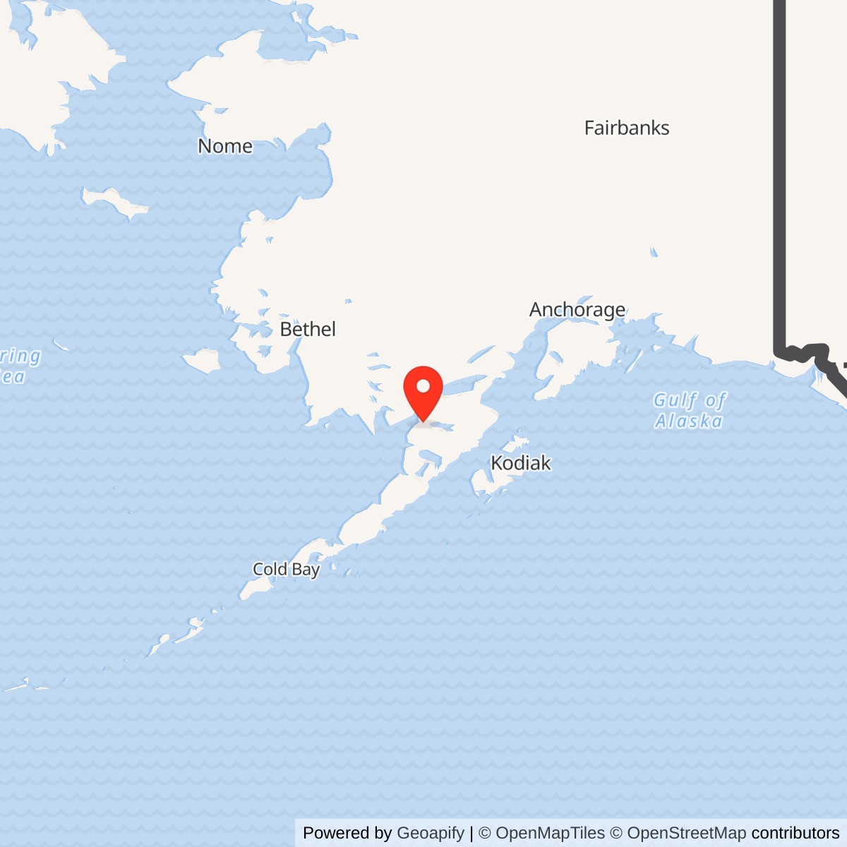
Longitude: -156.670167
Site Number: F-03; A-07
Current Role: Active AN/FPS-117-lineage Alaska long-range radar site with remote regional track processing and contractor maintenance; present radar-facility land title and exact surviving structure inventory require current parcel and field verification.
- Identity
- F-03 direction center, later A-07 Long Range Radar Site
- Representative location
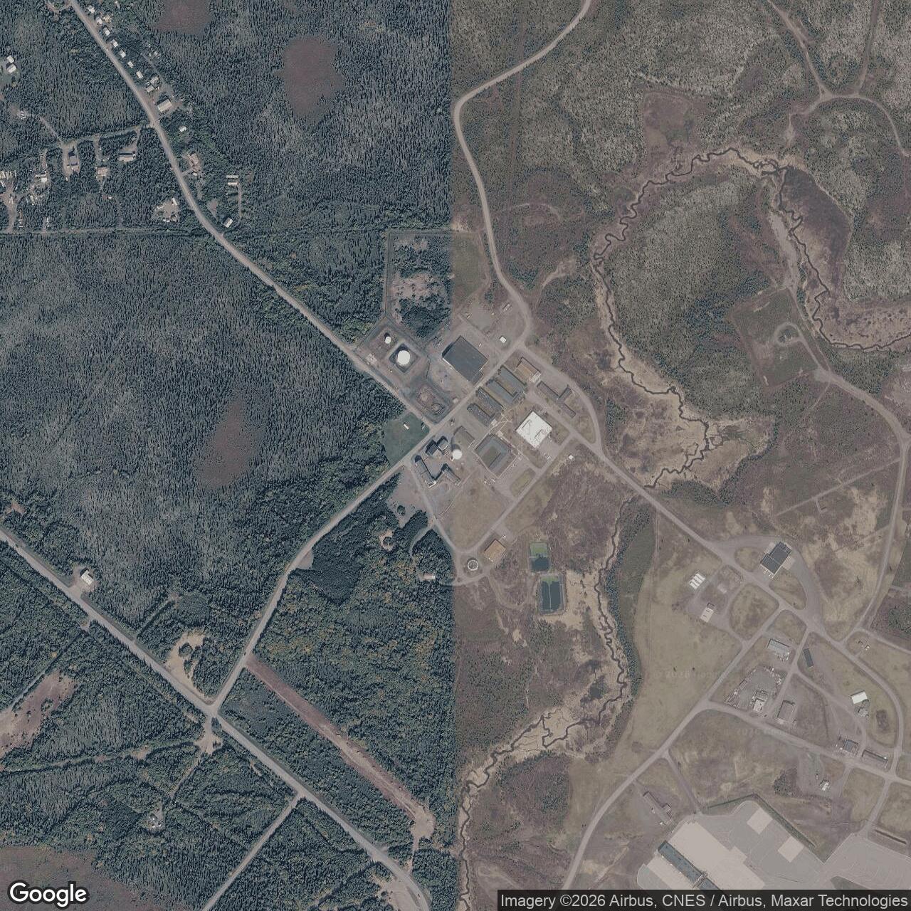
- 58.692583 N, 156.670167 W. Published modern radar-location reference, not a surveyed historic parcel or antenna center.
- Related site
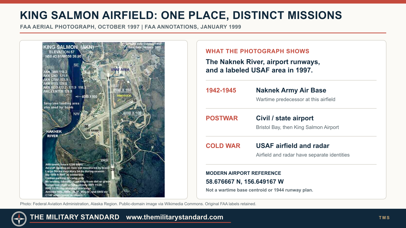
- Naknek Army Air Base was the wartime predecessor at the nearby airfield.
Identity and setting
King Salmon Air Force Station was the radar, aircraft-control, and southern Alaska air-defense direction installation at King Salmon. It was not simply another name for the runway or the fighter-alert airfield. The radar station shared a support landscape with the King Salmon Air Station forward operating location at the state-owned airport, and some buildings served both functions, but its surveillance and command mission followed a different operational clock. Its staffed Aircraft Control and Warning (AC&W) phase ran from November 1951 through the 705th Squadron's inactivation on 1 November 1983. The continuing King Salmon Long Range Radar Site is the same radar installation in a later, minimally attended form.
The installation stands near the Naknek River on the northern Alaska Peninsula, roughly 340 miles southwest of Anchorage. The low, wet landscape presented a different engineering challenge from the mountaintop radar stations elsewhere in Alaska: stable structures, utilities, communications, and reliable access had to be created in a remote place with lakes, wetlands, and limited overland transport. A current federal AN/FPS-117 radome-replacement location list identifies the King Salmon radar location as 58 degrees 41 minutes 33.300 seconds north, 156 degrees 40 minutes 12.600 seconds west, or approximately 58.692583 N, 156.670167 W. This is a published radar-site reference, not a surveyed parcel centroid, historic 1951 antenna pedestal, runway reference point, or boundary corner. The Alaska preservation study reports 727 acres for the larger King Salmon installation, comprising four main areas and 16 parcels. That total must not be entered as acreage for the radar parcel alone.
The airfield before the radar
The Civil Aeronautics Authority established an airport at King Salmon in 1931. After federal transfer to the Army in 1941, construction of Naknek Army Air Base began on 1 July 1942 and the physical base was considered complete on 22 September 1943, with runway improvements continuing into 1944. It served the wartime route toward the Aleutians and supported aircraft ferrying as well as fuel and rest needs. After the war the field returned to civil aviation administration as Bristol Bay Airfield. The Air Force came back as an airport tenant and forward operating base in 1948, years before the AC&W radar became operational. These predecessor and airfield stories explain why radar personnel could use a developed airport and support base, but they do not move the radar station's opening back to 1931, 1942, or 1948.
The Air Force's postwar concern was that Soviet aircraft approaching the North American continent across or around Alaska could exploit the immense distances between the few existing observation and fighter bases. King Salmon's position near Bristol Bay made it valuable both as an interceptor staging field and as a detection-and-control point for the southwestern approach. Alaskan Air Command selected it among the early permanent-system AC&W sites. A contract to build the radar installation went to Gaasland & Company on 12 April 1950. Construction finished in 1951 at a reported cost of about $3.67 million, but completion of buildings is not identical to operational acceptance. King Salmon began working as a ground-controlled-intercept (GCI) site in November 1951.
The original radar post combined radomes, one- and two-story prefabricated buildings, and enclosed arctic walkways. The latter were practical infrastructure, not decorative architecture: personnel had to move between operations, maintenance, power, and living functions in severe weather without repeatedly exposing equipment and people to the elements. Its first documented radar pairing was AN/FPS-3 search radar and AN/FPS-6 height finder. Search gave range and bearing; height finding and operator interpretation added the vertical information needed to assess a track and vector an interceptor. Specialist site inventories also list a CPS-5 backup and FPS-6B, but the official Alaska preservation study does not establish a site-specific installation date for either, so they are not treated here as confirmed opening-day equipment.
From local GCI to southern direction center
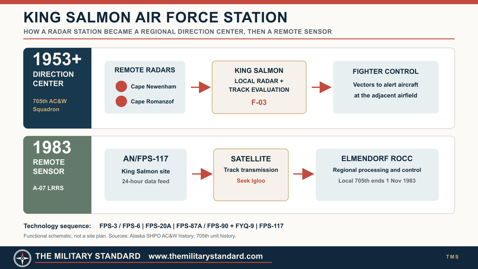
At first, Detachment F-3 of the 531st Aircraft Control and Warning Group operated and maintained King Salmon. Alaskan Air Command formalized the organization on 8 December 1952 when it activated the 705th Aircraft Control and Warning Squadron. On 4 March 1953, King Salmon became an air-defense direction center, later described as a NORAD Control Center. That was a substantive expansion. Operators were no longer merely reporting local radar plots and directing aircraft near their own station; they received information from outlying radars, evaluated tracks, and exercised tactical control over a broader southern sector. The center controlled, among others, Cape Newenham and Cape Romanzof Air Force Stations.
The difference between a radar report and an interception mattered operationally. A peripheral station might see an aircraft first, but its observations had to reach a direction center, be checked against known traffic, and be turned into a vector for aircraft on alert at an airfield. King Salmon's radar station supplied part of that picture and its controllers assembled a wider one. The King Salmon fighter-alert base could then put aircraft into the air. This physical closeness made the radar and airfield complementary, while leaving their commands, functions, and later closure histories distinguishable. The 705th remained the principal radar operating unit through several higher-headquarters reorganizations rather than being replaced every time the command structure changed.
Radar modernization and the first Soviet observation
The prime search set became AN/FPS-20A in 1958, increasing the station's ability to sustain long-range surveillance. Alaska's official AC&W history records the first observation by King Salmon radar operators of a Soviet reconnaissance aircraft off the Alaska coast in March of that year. An observation is not itself a fighter intercept, and the record should not be read as claiming one. The event nevertheless shows the strategic purpose of a continuously staffed coastal-approach radar: it could provide warning and track data before an unidentified aircraft reached the defended area. The wider network's effectiveness depended on the accuracy, persistence, and speed with which such observations were shared.
In the mid-1960s the search radar was modernized to AN/FYQ-9 semiautomatic data-processing and display system. The significance was not merely a longer equipment list. FYQ-9 reduced the delay and manual labor of passing track information, so the center could process the increasing volume of data from dispersed sensors more promptly. Sources do not give a reliable day-by-day King Salmon changeover for each set, and they differ in how they name later intermediate search-radar variants. This history therefore uses the official study's firm mid-1960s sequence without inventing exact activation days or assuming every published model suffix was a separate radar installation.
Communications and the White Alice link
The first radar network depended on high-frequency radio, which Alaska's atmospheric conditions often made unreliable. White Alice Communications System (WACS) links supplied a more dependable tropospheric-scatter and microwave backbone for moving warnings and command traffic across the state. The King Salmon WACS component activated on 25 May 1957. It was part of the communications infrastructure that let a local detection become a regional command decision, especially as King Salmon's control responsibility grew. The Air Force inactivated the King Salmon WACS component on 3 August 1979 and shifted service to an Alascom-owned and operated satellite earth terminal. These are communications milestones, not the radar station's opening or closure dates.
The White Alice equipment and power plant was on the larger King Salmon complex and was associated with the AC&W mission. The available history does not prove it occupied a separately controlled military parcel with a distinct installation administration.
The southern Alaska control mission
Fire Island near Anchorage had been another southern direction center. When its Air Force control mission ended in July 1969, King Salmon assumed responsibility for the other AC&W stations in the southern Alaskan Air Command sector. This changed its importance within the network, even though a radar set on its own property could not see all the airspace it now controlled. The center's operators depended on remote sensors, reliable circuits, recognition of friendly aviation, and the availability of interceptor aircraft. Its facilities and staffing consequently had to support sustained command-and-control work as well as ordinary radar maintenance.
The fighter operations at the adjacent forward operating base give the radar mission a concrete operational context. F-102s launched from King Salmon during the 14 March 1963 Soviet-aircraft incident but were recalled because of fuel before reaching the targets. On 2 September 1965, two F-102s flying from King Salmon successfully intercepted a Tu-16. These aircraft did not belong to the 705th radar squadron; they were part of the Alaska fighter-alert system that radar warning and controllers supported. Later F-15s from King Salmon participated in a multiple intercept on 17 September 1985 and an inter-service interception with Navy F-14s from Adak on 29 May 1987. Those later events occurred after the 705th's inactivation, showing why radar modernization and fighter-base drawdown must not be collapsed into a single end date.
Contract support and Seek Igloo
On 1 October 1977, Alaskan Air Command placed King Salmon base support under an RCA Services contract after a trial period. The contemporary Air Force-derived unit history says 28 positions were eliminated while 63 remaining military positions were primarily operational. The shift reflected both the cost of remote tours and the desire to reserve military manpower for control duties. In November of that year the 705th returned to the reactivated 531st Aircraft Control and Warning Group at Elmendorf; the group became the 11th Tactical Control Group on 1 July 1981. The changes did not yet make King Salmon unmanned, but they anticipated a different operating model.
King Salmon was chosen to test the AN/FPS-117 minimally attended radar under the Seek Igloo modernization program. The prototype was tested in September 1982 and placed in round-the-clock operation in December 1982. The new radar's track data went by satellite to the Regional Operations Control Center at Elmendorf, which achieved initial operational capability on 15 June 1983. Centralized processing replaced the need for a large local crew to interpret every track at King Salmon. The 705th Squadron inactivated on 1 November 1983; the site continued as King Salmon Long Range Radar Site, A-07, with contractor maintenance. The Air Force-derived account reported that only two contractor maintenance and support personnel were required locally because the airport was nearby. The staffed direction center ended, but the surveillance sensor did not.
Facilities, people, and preservation
King Salmon's shared airfield and radar complex grew larger than a typical isolated AC&W camp. The Alaska preservation booklet reports more than 70 buildings in the King Salmon forward operating base landscape, including alert hangars, fuel storage, dormitories, dining, maintenance, power, recreation, and other support functions. Remote supply was a major operational constraint. King Salmon and Galena carried 13-month stock levels, and annual waterborne resupply proceeded under the Mona Lisa and later Cool Barge programs. Such support enabled an always-on radar and alert mission through weather and shipping seasons; it should not be mistaken for evidence that every listed building was inside the radar technical parcel.
Historic-resource surveys further show how closely the missions were physically integrated. A December 1998 evaluation examined 71 structures in the main base, Radar Approach Control area, and marina. Eleven facilities and connected walkways were identified as contributors to a discontiguous historic district representing the 1948-1989 forward operating base period. Three of those contributors were later demolished during environmental restoration. The official inventory names, among the remaining contributors, Combat Alert Cell/Alert Hangar 160, communications tower 327, power stations 335 and 638, radome tower 625, vehicle buildings 632 and 636, and engineering shop 642. The radar study separately identifies surviving minimally attended radar support structures. These dated inventories document historic fabric, not a guarantee that every feature remains standing and accessible in 2026.
End of the fighter-alert era and current status
The airfield's permanent fighter presence ended later than the staffed radar center. Third Wing F-15s departed full-time alert on 29 April 1994, all active-duty personnel left by 30 September, and the airport became a contractor-maintained contingency field on 1 October. The state preservation study describes the radar as continuing unmanned. These statements are compatible: 1994 was a major withdrawal from the adjacent forward operating base, not closure of the AN/FPS-117 surveillance mission. Contemporary Air Force procurement material still lists King Salmon among AN/FPS-117 long-range radar locations, and the site remains part of the Alaska radar architecture rather than a wholly abandoned former station.
Property control is more complex than a single owner label. The airport land passed from federal aviation administration to Alaska state ownership in 1959 while the Air Force retained lease rights. A 2000 Air Force environmental decision document describes mixed federal interests and states that Paug-Vik, Ltd. leased the radar-facility land to the Air Force at that time. It also describes the main developed area west and north of the airfield. That dated statement is important evidence of a radar-specific land interest, but it is not a verified 2026 title report. The 727-acre figure in the preservation study covers a larger multi-area installation and cannot safely be assigned to F-03/A-07 alone.
Environmental work likewise crosses administrative and physical subareas. Air Force and Alaska Department of Environmental Conservation records track fuel, solvents, fire-training areas, landfills, tanks, and groundwater zones around the former air station and airport. DEC still lists the Zone 5 fire-training/landfill groundwater case active and describes some contamination as remediated, another area under treatment, and other areas under investigation. A 2025 cleanup-complete determination for the Building 300 waste-oil tank addresses that defined tank site only. These records neither establish that the radar parcel is contaminated everywhere nor justify declaring the whole former complex clean. Public access, reuse, and any institutional controls must be checked against the relevant parcel and DEC case rather than inferred from the operational radar status.
Role in the Wider Military Network
King Salmon linked southwestern Alaska's sensors, controllers, and aircraft. Cape Newenham, Cape Romanzof, and other remote AC&W stations extended detection toward the Bering Sea; King Salmon assembled their reports and, after 1969, served as the principal southern control point. White Alice and then satellite circuits carried the information. The nearby forward operating base positioned interceptors closer to potential tracks than Elmendorf alone could, while Elmendorf supplied higher-level command and, after Seek Igloo, centralized radar processing. Thus the site illustrates a larger shift in continental defense from local operators manually interpreting multiple radars toward remote sensors feeding a regional operations center. Its 1983 reorganization reduced staff but preserved a strategic surveillance role.
Chronology
- 1931 Civil Aeronautics Authority establishes the King Salmon airport.
- 1941 Airport passes to the Army for wartime use.
- 1942-07-01 Construction of Naknek Army Air Base begins.
- 1943-09-22 Wartime base physical area is reported complete; improvements continue.
- 1944 Army continues runway and base improvements.
- 1948 Air Force begins forward operating use of the postwar civil airfield.
- 1950-04-12 Gaasland & Company receives the AC&W radar construction contract.
- 1951 Radar installation construction is completed at a reported cost of about $3.67 million.
- 1951-11 King Salmon begins operational ground-controlled-intercept radar service.
- 1952-12-08 705th Aircraft Control and Warning Squadron activates, succeeding Detachment F-3's initial operation.
- 1953-03-04 Station converts to an air-defense direction center.
- 1954 Airfield and associated base take the King Salmon Air Station name.
- 1957-05-25 King Salmon White Alice communications component activates.
- 1958-03 King Salmon radar operators observe a Soviet reconnaissance aircraft off Alaska's coast.
- 1958 AN/FPS-20A becomes the prime search radar; center gains a NORAD Control Center role in the southern sector.
- 1959 Alaska state ownership succeeds federal civil-aviation ownership of the airfield, with Air Force lease rights retained.
- 1963-03-14 King Salmon F-102s scramble toward Soviet aircraft but are recalled because of low fuel.
- mid-1960s AN/FPS-87A, AN/FPS-90, and AN/FYQ-9 modernization improves search, height finding, and track processing.
- 1965-09-02 Two F-102s launched from King Salmon successfully intercept a Tu-16.
- 1969-07 Fire Island control-center closure transfers the remaining southern AC&W control responsibilities to King Salmon.
- 1977-10-01 RCA Services begins contracted base support; military positions are reduced.
- 1977-11-15 705th Squadron returns to the reactivated 531st Aircraft Control and Warning Group.
- 1979-08-03 King Salmon WACS component inactivates; Alascom satellite service replaces it.
- 1981-07-01 531st Group becomes the 11th Tactical Control Group.
- 1982-09 Prototype AN/FPS-117 testing begins under Seek Igloo.
- 1982-12 AN/FPS-117 begins round-the-clock operation at King Salmon.
- 1983-06-15 Elmendorf Regional Operations Control Center reaches initial operational capability.
- 1983-11-01 705th Squadron inactivates; staffed direction-center phase ends while LRRS radar service continues.
- 1985-09-17 King Salmon-based F-15s participate in a multiple Soviet-aircraft intercept under network control.
- 1987-05-29 King Salmon F-15s and Adak-based Navy F-14s conduct an inter-service intercept.
- 1994-04-29 F-15s depart full-time King Salmon alert.
- 1994-09-30 Active-duty Air Force personnel depart the forward operating base.
- 1994-10-01 Airport forward operating location enters contractor-maintained contingency status; radar remains active.
- 1998-12 Historic-resource survey evaluates 71 main-base, RAPCON, and marina structures and identifies district contributors.
- 2000-11 Environmental decision document records Air Force lease of radar-facility land from Paug-Vik, Ltd. at that time.
- 2025-10-31 DEC closes the defined Building 300 waste-oil tank case; other King Salmon cases remain separate.
- 2026 AN/FPS-117 site remains in federal sustainment listings; current parcel title and full structure survival need verification.
Information sources (10)
- PDFHistory of the Aircraft Control and Warning System in Alaska: Air Defense of Arctic Skies, Alaska Department of Natural Resources / Alaska State Historic Preservation Office
Source for installation context, construction, radar modernization, WACS, Seek Igloo, buildings, and historic-resource findings.
- PDFDefending Attack From the North: Alaska's Forward Operating Bases During the Cold War, Alaska State Historic Preservation Office / Argonne National Laboratory for the U.S. Air Force
Source for airfield predecessor, logistics, fighter-alert events, direction-center chronology, 1994 drawdown, and historical photographs.
- PDF705 Aircraft Control and Warning Squadron, Air Force Historical Research Agency material reproduced by USAF Unit History
Source for exact organization, 1950 contract, 1953 direction-center date, White Alice, RCA contract, Seek Igloo tests, and 1983 inactivation. Unit-history compilation is not a land survey.
- WEBLong Range Site Locations and Addresses, AN/FPS-117 radome replacement program, U.S. Air Force Life Cycle Management Center procurement attachment hosted by GovTribe
Source for current King Salmon long-range radar location. Hosted copy is a location-list reference, not a surveyed boundary.
- WEBKing Salmon AS Groundwater Zone 5 OT031 site report, Alaska Department of Environmental Conservation
Source for active DEC case and status of former fire-training and landfill areas, demonstrating that cleanup status is subsite-specific.
- WEBKing Salmon AS Groundwater Zone 2 OT028 site report, Alaska Department of Environmental Conservation
Source for active base-industrial groundwater case illustrating continuing restoration oversight on the broader complex.
- WEBKing Salmon AS GWZ 2 TU/US-C519 UST 300-1 site report, Alaska Department of Environmental Conservation
Source for October 2025 cleanup-complete determination for a defined Building 300 tank site, not an installation-wide clearance.
- PDFKing Salmon Air Station, Groundwater Zone 1 Interim Record of Decision, U.S. Air Force decision document hosted by Alaska Department of Environmental Conservation
Source for dated land-use and ownership account identifying Paug-Vik radar-facility lease and main-base location in 2000.
- WEBKing Salmon Air Force Station site inventory, Radomes, Inc
Source for F-03/A-07, approximate radar point, call signs, equipment leads, and historic photographs. Secondary source, qualified where it differs from official study.
- WEBKing Salmon Air Force Station recent photographs, Radomes, Inc. contributors
Source for dated visual reference for surviving and removed structures, not an independently verified condition inventory.