
Northway Army Airfield, Alaska
A remote construction airlift became a working stop on the aircraft route to Fairbanks and Siberia.
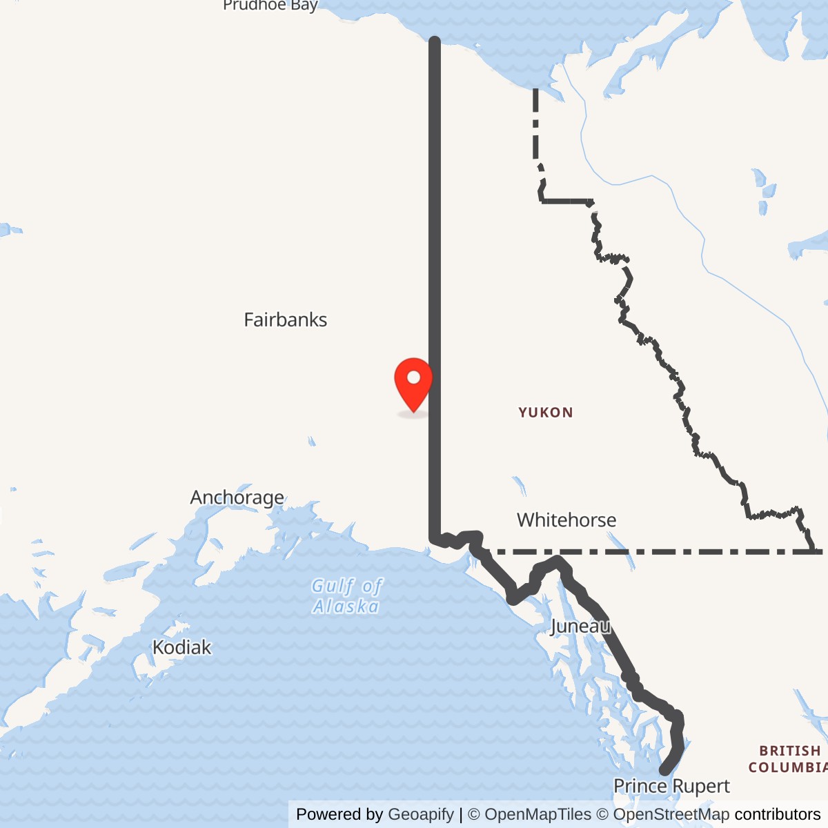
Longitude: -141.9282
Airport ICAO ID: PAOR
Official Base Website: Northway Airport
Current Role: Northway public airport operated by Alaska DOT&PF
- Role
- Northwest Staging Route refueling, servicing and aircraft staging
- Military service
- U.S. Army Air Forces / Air Transport Command
- Early airport construction
- Civil Aeronautics Administration project, spring 1941
- Army garrison construction
- July 18, 1942
- Engineer unit
- Company F platoon, 176th Engineer Regiment (General Service)
- Initial accommodation program
- 13 officers and 140 enlisted men
- Initial medical provision
- Four-bed hospital
- Original runway
- 5,300 × 350 feet
- Expanded wartime runway
- 7,500-foot length; summer 1944 paving planned
- Buildings
- Quonset huts, frigid-zone temporary buildings and winterized tents
- Fuel handling
- Drums, four 25,000-gallon tanks and pumping station shown in 1943 plan
- Communications
- AACS receivers, airfield control and separated ACS transmitters
- Airport transfer
- Most facilities transferred to Alaska in 1966
- Current airport
- Northway Airport, PAOR / ORT
- Location
- Beside the Nabesna River near Northway, eastern interior Alaska
The First Alaska Stop on the Northern Air Route
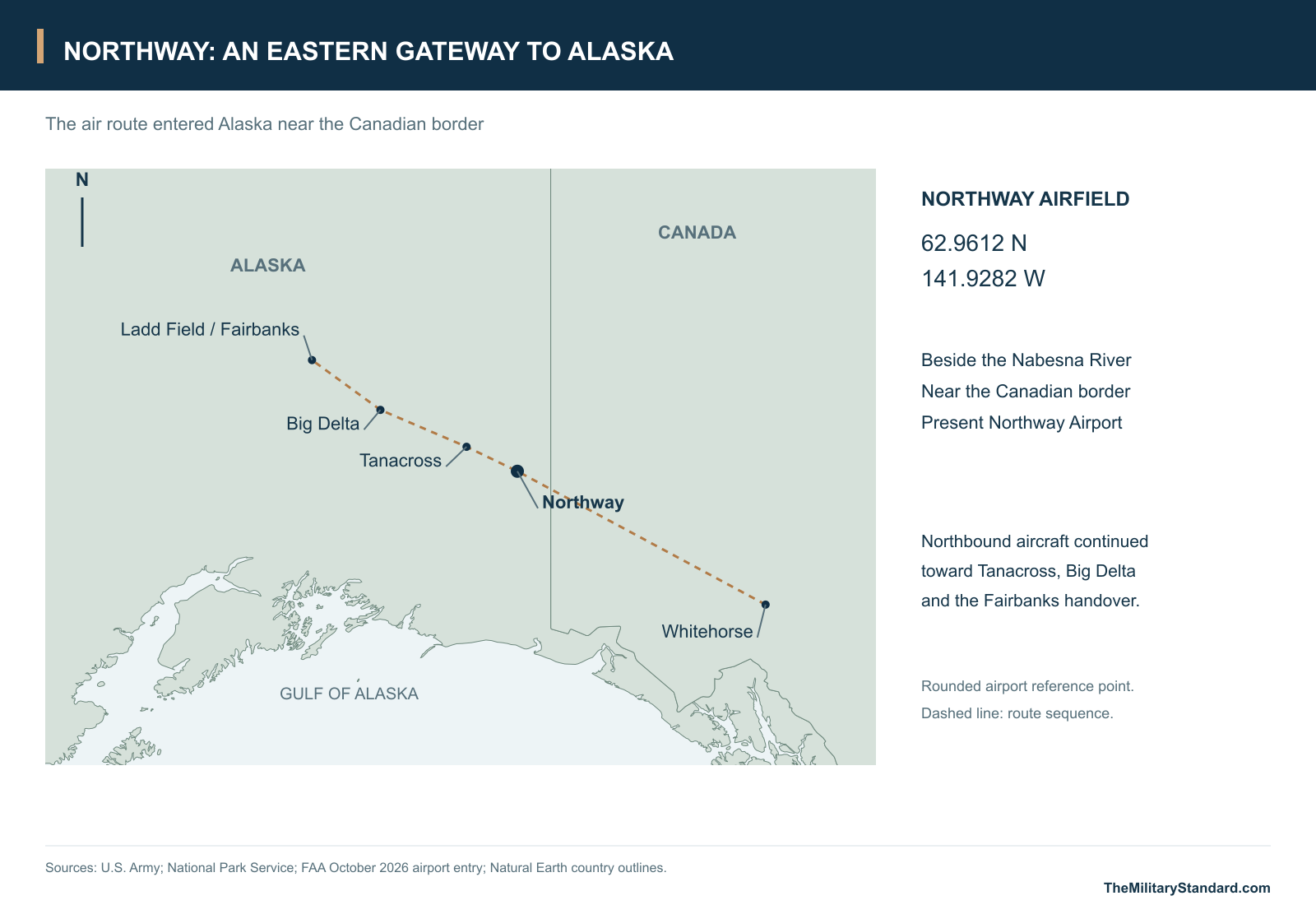
Northway Army Airfield stood close to the Canadian border, where the aircraft route through western Canada entered the Territory of Alaska. From its lowland setting beside the Nabesna River, aircraft could continue through Big Delta toward Fairbanks. In World War II, this position made Northway a refueling, servicing and staging stop for airplanes and supplies moving into Alaska, including aircraft being delivered to the Soviet Union under Lend-Lease. Its importance lay in keeping successive flights moving across a very long route, with enough fuel, ground support and shelter to make the next stage possible. [1] [4] [5]
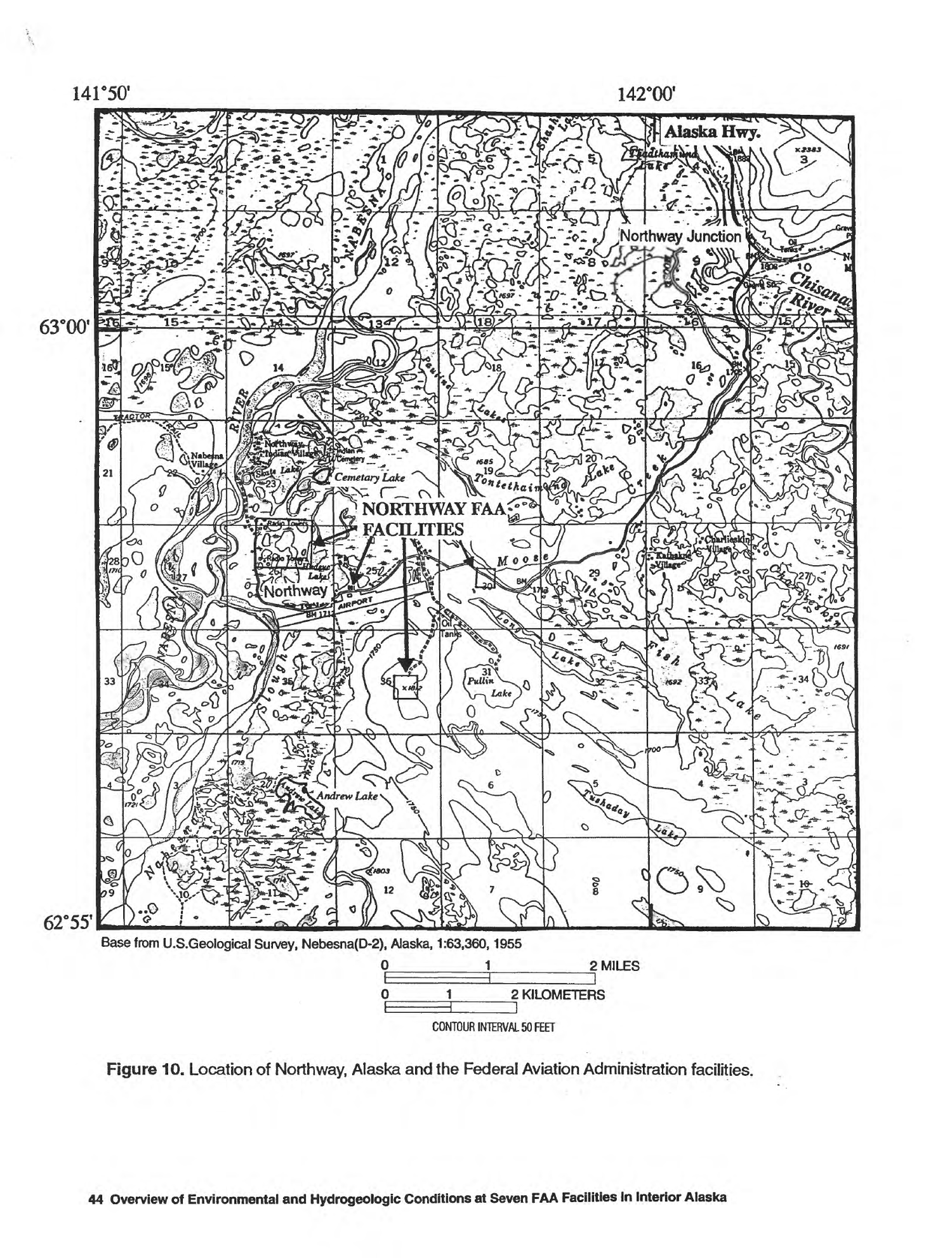
The airfield occupied an existing Athabascan homeland rather than an empty construction site. Northway's communities included the Native village, the airport settlement and Northway Junction on the Alaska Highway. The runway lay between the Nabesna watercourses to the west and Moose Creek to the east, among lakes, muskeg and frozen alluvial ground. That terrain gave builders a relatively flat runway corridor but complicated access, drainage, foundations and waste disposal. The military installation and the surrounding community therefore shared both the opportunities created by aviation and the consequences of building on a wet, seasonally changing landscape. [1] [7] [8]
Building an Airfield Before the Road
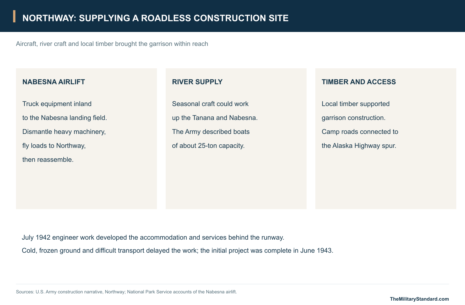
Civilian aviation work preceded the Army garrison. The Civil Aeronautics Administration awarded the Northway airport construction contract in spring 1941, when the site still lacked the road connection that would later make the Alaska Highway a supply artery. Morrison-Knudsen and Alaska's bush pilots assembled an airlift from the Nabesna landing field to Northway. Bob Reeve helped move construction equipment that had first been trucked inland from Valdez; heavy machines were dismantled into loads his Boeing Trimotor could carry, flown to the work site and put together again. Improving the departure strip was itself part of the construction problem. [2] [3]
Harold Gillam and other pilots continued the Nabesna-Northway lift as military demands expanded. Air transport brought machinery and stores to a place where construction could not simply begin with truckloads arriving at a roadside job. A second approach was available in the navigation season: the Army described river craft of about 25-ton capacity traveling up the Tanana from Big Delta, entering the Nabesna and continuing approximately seven miles upstream to the garrison. These complementary routes explain why aircraft, river landings, local timber and the eventual highway connection all mattered to one airfield project. [1] [2]
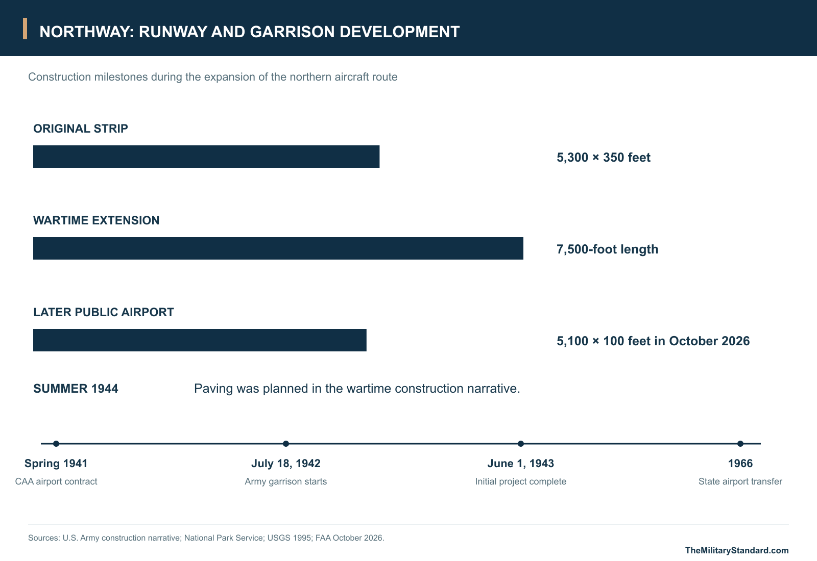
Army garrison construction began on July 18, 1942, with a platoon of Company F, 176th Engineer Regiment, General Service. Lieutenant Donald D. Blotcky served as resident engineer. The original program provided for 13 officers and 140 enlisted men, a four-bed hospital and an Air Corps operations building. These were the requirements of the initial approved construction project; the field subsequently grew as the aircraft-ferry mission demanded more facilities. On June 1, 1943, the Army considered that original project essentially complete and assigned further new work to the Northwest Service Command. [1]
Servicing the Lend-Lease Stream
Air Transport Command used Northway as one station in a chain rather than as an isolated flying base. Its Alaskan Wing organized aircraft movement and ground support along the Northwest Staging Route, while the construction agencies supplied the runways, parking and accommodation on which the operation depended. The official Air Forces history places a relatively small ATC contingent at Northway early in 1943, alongside larger organizations at major route centers. A small local detachment could nevertheless be a critical link: an aircraft delayed for servicing or weather at an intermediate stop could not continue merely because the destination had capacity. [4]
Northbound Lend-Lease aircraft passed through Canadian staging fields before reaching Northway, then continued toward Ladd Field at Fairbanks. American crews delivered the aircraft to the handover point; Soviet crews took them westward through Alaska toward Siberia. Tanacross and Big Delta furnished intermediate support before Fairbanks, while Galena and Marks Field at Nome belonged to the onward western chain. The system joined many kinds of work: flight planning, weather reporting, fuel handling, repairs, communications and accommodation for transient crews. Northway's contribution was the dependable intermediate stop at the eastern end of Alaska's part of that system. [4] [5]
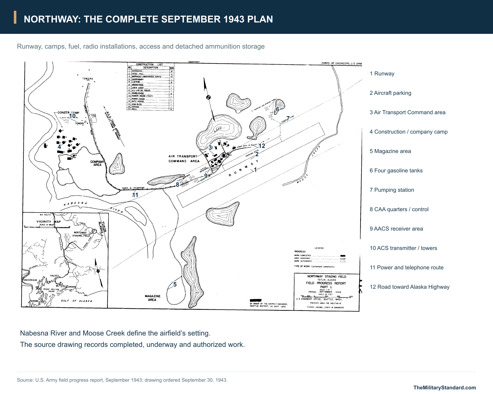
The physical airfield changed with the traffic. The Army construction narrative describes an original runway 5,300 feet long and 350 feet wide, subsequently extended by the CAA to 7,500 feet. It also recorded a plan to pave the strip in summer 1944. Additional work was associated with the Northwest Service Command's expansion of the ferry route to Russia. The September 1943 progress drawing places aircraft parking beside the runway and groups the ATC camp on the adjoining side, with the road connection leading toward the Alaska Highway. The camp, communications facilities and airfield surfaces were parts of the same operating system. [1]
The September 1943 Layout
The Army's September 1943 field-progress plan shows a dispersed installation. The runway forms the long eastern axis, with parking and the Air Transport Command area beside it. The construction or company camp stands farther west, near the Nabesna River. Roads connect these groups, while power and telephone lines follow the connecting corridor. A magazine area lies away from the occupied camps on the other side of the access system. Lakes and drainage channels interrupt the available land, explaining why the base did not develop as one compact rectangle of buildings. [1]
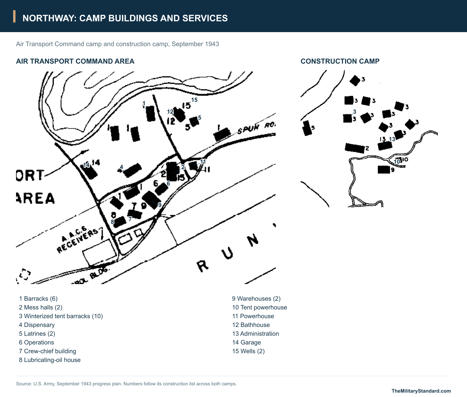
Within the ATC area, the plan identifies operations, a crew-chief building, barracks, a mess hall, a dispensary, warehouses, garage, administration building and bathhouse. Wells, latrines and powerhouses supplied the less conspicuous services needed to keep that accommodation usable. The construction list covers both occupied groups and distinguishes six barracks from ten winterized tent barracks. It lists two mess halls, two warehouses, two latrines and two wells, as well as the individual specialist buildings. A separate tent powerhouse appears in addition to the regular powerhouse. The plan's different shadings distinguish completed, underway and authorized construction in that particular reporting period. [1]
Fuel and communications extended beyond the accommodation blocks. The narrative says gasoline was stored mainly in drums, while the plan also locates four 25,000-gallon Air Corps gasoline-storage tanks and a pumping station north of the camp. The drawing marks a lubricating-oil house, an AACS receiver area and a control building near the airfield. It also depicts radio towers and an ACS transmitting installation toward the construction camp, noting a transmitter offset of approximately 6,000 feet from the runway centerline. Those separated radio locations allowed the drawing to describe a larger working installation than the buildings immediately beside the aircraft parking area. [1]
Working Through Cold and Community Change
Northway's buildings were a practical response to interior-Alaska conditions. The camp used Quonset huts and temporary frigid-zone buildings, and locally available timber supplied a substantial part of the garrison's construction material. The Army described frozen sand and gravel beneath a cover of muskeg, with severe cold, difficult transportation and winter dependence on aircraft slowing the work. Temperatures around 60 degrees below zero were reported as a recurring construction condition. Heating quarters, maintaining engines, protecting water systems and keeping ground equipment usable were continuous demands on a base intended to serve aircraft through winter. [1]
The building groups show how much work took place away from the runway. Meals required mess halls and stores; illness and injury required a dispensary; vehicles and generators needed repair and fuel; washing and sanitation required water, a bathhouse and latrines. The initial four-bed hospital provision was modest, but it was part of a complete garrison program rather than an optional amenity. Barracks and winterized tents housed the people whose daily work made the field useful to transient aircraft. These support facilities help explain why a staging stop could occupy a landscape much larger than its runway and apron. [1]
Local residents also experienced the construction directly. The Northway Community Plan records employment in brush clearing and recalls a much larger base at the height of wartime activity. It also describes a serious loss: airport construction disturbed a Native cemetery, with graves dug up and burned at the ends of the airfield. The community's account gives the strategic success a local dimension that the engineering progress sheets do not convey. Wartime development brought wage work and transport connections while disrupting land, burial places and an established way of life. [8]
Water was another persistent part of the installation's story. A later environmental record preserves residents' reports that a 1944 flood carried numerous drums into Nabesna Slough near the western end of the runway. The account connects wartime fuel handling with the river landscape and the debris found decades afterward. It also helps explain why later investigations followed sloughs, lakes, former tank areas and drainage paths rather than treating the runway pavement as the whole former base. [11]
Civilian Airport and Later Military Properties
The intensive wartime staging role declined at the end of World War II. Civil aviation authorities operated Northway during and after the war, and in 1966 most of the airport facilities passed to the State of Alaska. This was a change in airport ownership and operation after years of civilian use, rather than a single date on which every military interest in the surrounding area ended. Northway continued to serve aviation across the Canadian border, with its flight-service station, navigation aids and airport community giving the wartime investment a long civilian life. [7] [10] [16]
Later military properties belonged to different periods and parcels. Northway ACS at Northway Junction was used by the Army Signal Corps from 1951 to 1962 and by the Northway Army Site made up of tracts acquired in the 1960s for facilities including a hangar, fuel tanks, pipelines and a latrine. Returns of those tracts to Alaska and the Bureau of Land Management in 1972 and 1975 were later property milestones, separate from the wartime garrison's decline. [9]
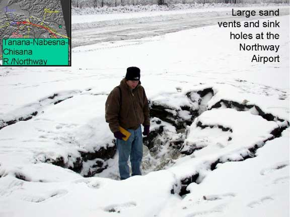
The civilian airport also faced the same difficult ground that had challenged its builders. The November 3, 2002 Denali earthquake caused liquefaction and lateral spreading at Northway, splitting the frozen surface and runway pavement with large fissures. Sand vents and sinkholes appeared around the runway, and the damage made the airport unusable. The reconnaissance photographs show that the problem was movement of the supporting ground, not simply a worn pavement surface. The event became another major episode in the engineering history of this lowland airfield. [13]
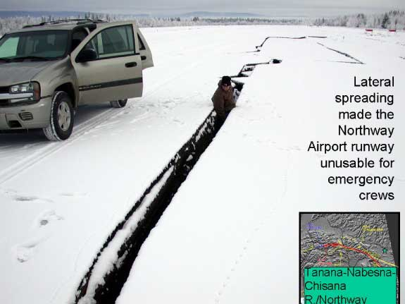
The reconnaissance documented many cracks about 10 to 30 centimeters wide, with some openings wider than a meter. Around the runway, sand vents and sinkholes reached about four meters across and a meter deep. Residents reported pressurized groundwater throwing soil into the air. Although the surface layer was frozen, the underlying ground could still liquefy and spread laterally. The damage exposed the relationship between the runway's serviceable surface and the water-bearing sediments beneath it. [13]
The Airfield Today
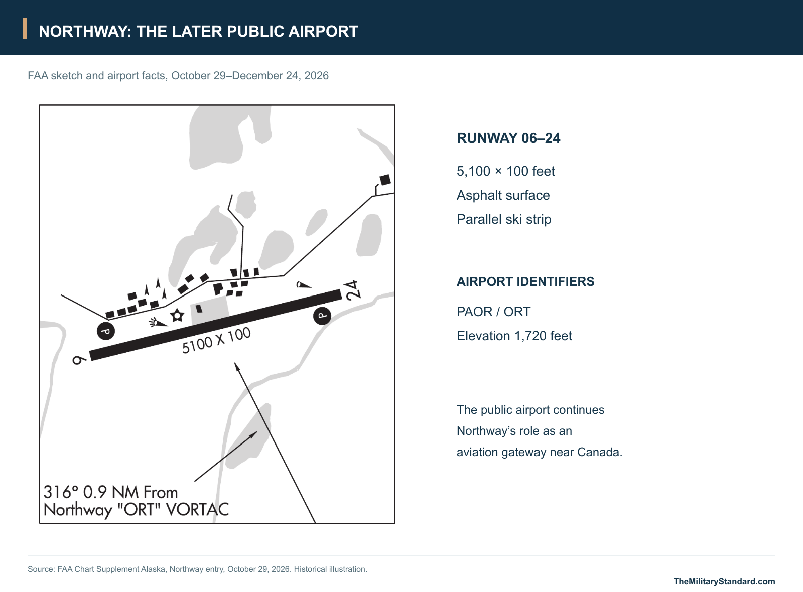
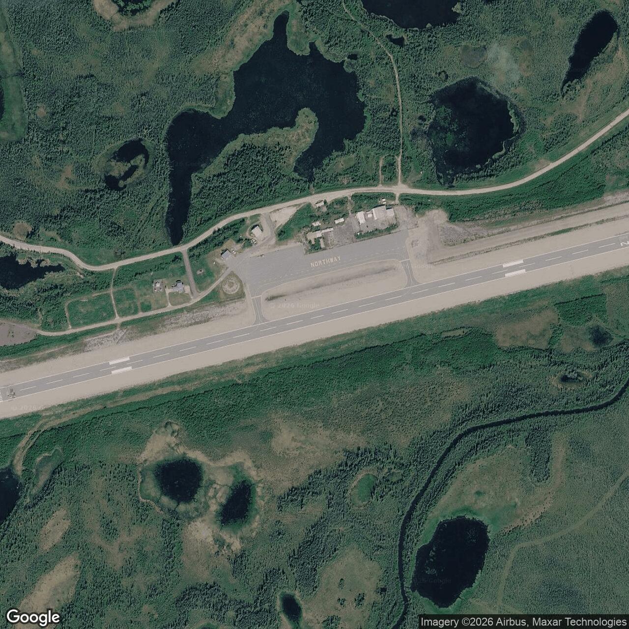
Northway remains a public airport under Alaska DOT&PF. The FAA's October 29, 2026 airport entry identifies PAOR/ORT, an elevation of 1,720 feet and asphalt runway 06-24 measuring 5,100 by 100 feet, with an adjacent ski strip. Those are the later airport's dimensions, distinct from the much wider wartime runway program. The published airport reference point, approximately 62.9612 N, 141.9282 W, locates the airfield; the dispersed wartime installation extended beyond that point. [14]
Restoration records preserve the geography of the former base in another form. Some investigated areas have been closed, including the OU1 group covered by a December 2002 decision, while the former fuel-storage area at Ham Lake has continued to receive monitoring and review. Alaska DEC's November 2024 action gave only partial approval to a groundwater report and called for better definition of contamination and further evaluation. The different decisions apply to particular areas. They do not describe one uniform cleanup outcome for every piece of the former staging field. [11] [12]
Northway's enduring significance is the connection between a remote construction effort and an international air route. Bush pilots and engineers first made a runway and garrison accessible; service personnel then turned them into a working stop for aircraft crossing Alaska; civil aviation inherited the airfield when the wartime traffic receded. The surviving airport, original plans, radio-site records and community memories preserve different parts of that history, from the aircraft-delivery mission to the people and landscape that sustained it. [1] [2] [7] [8]
Chronology
- Spring 1941 The CAA awards the airport construction contract; the Nabesna-Northway equipment airlift supports the work. [2] [3]
- January 14, 1942 Northway's CAA communications facility, KHDI, is commissioned. [6]
- July 18, 1942 A Company F platoon of the 176th Engineer Regiment starts Army garrison construction. [1]
- 1942 Northway becomes an Alaska stop in the developing Lend-Lease aircraft-ferry chain. [4] [5]
- June 1, 1943 The initial approved garrison project is essentially complete; further new work becomes a Northwest Service Command responsibility. [1]
- September 1943 The Army progress plan records the runway, ATC area, construction camp, radio facilities, fuel storage and detached magazine area. [1]
- 1943-1944 The construction narrative records extension of the runway from 5,300 to 7,500 feet and planned paving in summer 1944. [1]
- 1944 Residents later report that flooding carries military drums into Nabesna Slough. [11]
- After World War II The major wartime Army staging role ends and civilian airport operation continues. [7] [10]
- 1951 Army Signal Corps use begins at the separate Northway Junction ACS station. [9]
- 1962 The Air Force succeeds the Army at Northway ACS. [9]
- 1963-1964 The later Northway Army Site obtains tracts through BLM and FAA arrangements. [9]
- 1966 Most airport facilities pass to the State of Alaska; the later Army Site retains separate reserved tracts. [7] [9]
- 1970 The Corps inventory places the end of Air Force use at Northway ACS in this year. [9]
- 1972-1975 The later Army Site's tracts are returned to Alaska and BLM in separate actions. [9]
- 1995 The Corps records a substantial hazardous-debris removal at the former staging field. [9]
- November 3, 2002 The Denali earthquake damages the airport through liquefaction and lateral spreading. [13]
- December 23, 2002 A decision closes the OU1 environmental-investigation group. [11]
- September 28, 2012 A decision document is approved for the Ham Lake environmental project. [12]
- November 2024 DEC partially approves the Ham Lake monitoring report and identifies further groundwater questions. [12]
- 2026 The FAA lists the public airport with a 5,100-by-100-foot asphalt runway and a parallel ski strip. [14]
Related Sites
Information sources (16)
- PDFU.S. Army, Narrative Report of Alaska Construction, 1941-1944, Northway, printed pages 110-113
Army garrison construction, original accommodation and hospital program, engineer unit and resident engineer, runway expansion, river transport, winter conditions, June 1943 completion and September 1943 progress plan.
- PDFNational Park Service, At Work in the Wrangells: A Photographic History, printed page 131
Civil Aeronautics Administration contract in spring 1941, Nabesna construction airlift, Morrison-Knudsen work and the roles of Bob Reeve, Harold Gillam and other Alaska pilots.
- WEBNational Park Service, Reeve's Field Trailhead
Equipment moved by truck to the Nabesna strip, dismantled for air transport and reassembled at Northway during the 1941 construction effort.
- WEBU.S. Air Force, The Army Air Forces in World War II, Volume VII, chapter 6: The Northwest Air Route to Alaska
Air Transport Command's Alaskan Wing, small Northway detachment in 1943, construction responsibilities, route expansion and the demands of winter aircraft movement.
- WEBNational Park Service, Ladd Field and the Lend-Lease Mission: Defending Alaska in WWII
Northway, Tanacross and Big Delta in the aircraft-delivery chain; transfer to Soviet crews at Ladd Field and the onward Alaska-Siberia route.
- PDFFederal Aviation Administration, Civil Aviation Policy in Alaska
Wartime civilian aviation facilities, Northway KHDI communications commissioning on January 14, 1942, and postwar transfer of military air-navigation functions.
- PDFU.S. Geological Survey, Overview of Environmental and Hydrogeologic Conditions at Seven Federal Aviation Administration Facilities in Interior Alaska, Open-File Report 95-341, 1995
Northway geography, 1966 transfer of most airport facilities to Alaska, FAA navigation aids, permafrost, wetlands and figure 10 location map; printed pages 43-49.
- PDFNorthway Village Council and Tanana Chiefs Conference, Northway Community Plan 2021-2026
Local account of wartime employment, cemetery disturbance, extensive base construction and lasting community changes.
- WEBU.S. Army Corps of Engineers, FUDS property inventory, Northway records, fiscal year 2024
Separate Northway Staging Field, later Northway Army Site and Northway ACS identities; ACS Army and Air Force periods; later Army tracts, permits and property returns.
- WEBAlaska Department of Environmental Conservation, ADOT&PF Northway Airport Lease Lots Block 8, Hazard ID 4324
1941 construction, wartime refueling and maintenance, highway and pipeline support, postwar civilian operation, 1966 transfer and later lease-lot investigations.
- WEBAlaska Department of Environmental Conservation, Northway Staging Field OU1, Area 18, Hazard ID 249
Residents' account of the 1944 flood carrying drums into Nabesna Slough and the December 23, 2002 closure of the OU1 group.
- WEBAlaska Department of Environmental Conservation, Northway Staging Field OU2, Areas 40 and 43, Ham Lake, Hazard ID 2353
Former fuel-storage area, 2012 decision, continued groundwater work and the qualified partial approval of the 2023 monitoring report in November 2024.
- WEBU.S. Geological Survey, The Great M7.9 Denali Fault, Alaska, Earthquake of November 3, 2002: Liquefaction and Ground Displacement
Northway runway damage from liquefaction and lateral spreading; two photographs of fissures and sand vents taken during the earthquake reconnaissance.
- PDFFederal Aviation Administration, Chart Supplement Alaska, October 29-December 24, 2026, Northway entry
Airport reference coordinates, PAOR/ORT identifiers, elevation, asphalt runway 06-24 dimensions, parallel ski strip and civilian aviation facilities.
- WEBNatural Earth, public-domain map data
Country outlines used for the regional location diagram; installation points are plotted separately from documented geographic coordinates.
- WEBFederal Aviation Administration, FAI FSS: Northway, Gateway to Alaska, updated July 27, 2020
Later airport's border-entry role, seasonal flight-service station and local airport advisory service.