
Cold War radar network
The Distant Early Warning Line
Radar outposts across the Arctic and Aleutians gave North America time to respond to aircraft approaching from the north. Explore the full station directory, the technology, and the people and communications that made the warning line work.
What Was the DEW Line?
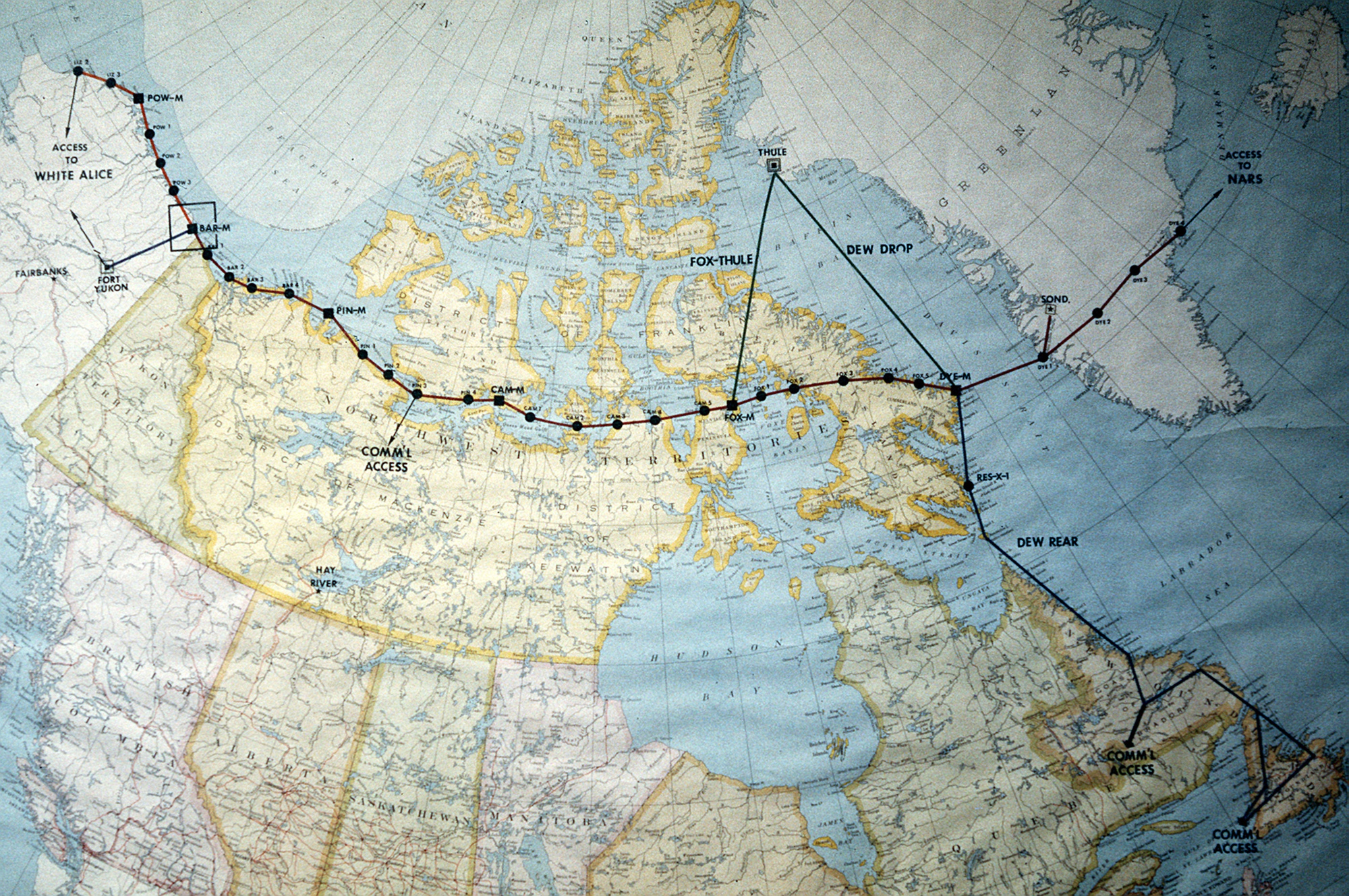
The Distant Early Warning (DEW) Line was a chain of radar and communications stations across the northern approaches to North America. Its mission was aircraft warning: to detect a possible bomber attack early enough for air-defense forces to alert, disperse and prepare. The original line joined Alaska and Canada; extensions reached the Aleutians and farther into the North Atlantic. It was a military network, not one base or one model of radar. [1] [2]
For the story behind the station directory, read the complete DEW Line history, from the 1952 planning study and Arctic construction to daily operations, later extensions and the North Warning System.
A 1952 study at MIT Lincoln Laboratory proposed surveillance radars and communications across the Arctic. Western Electric built and operated much of the early network under Air Force direction, while American and Canadian forces supplied essential transport and support. The original line was declared operational on July 31, 1957. Its distant sites depended on aircraft, sealift, fuel stores, power plants and technicians as surely as they depended on radar transmitters. [1] [2]
How It Worked
Main and auxiliary radar stations watched sectors of the sky. An aircraft return had to be assessed by people and sent onward through communications links to the air-defense command organization. Between some main radar sites, AN/FPS-23 gap-filler equipment provided additional low-altitude warning. The radar line could warn of aircraft, but it was not a ballistic-missile warning system. [1] [2]
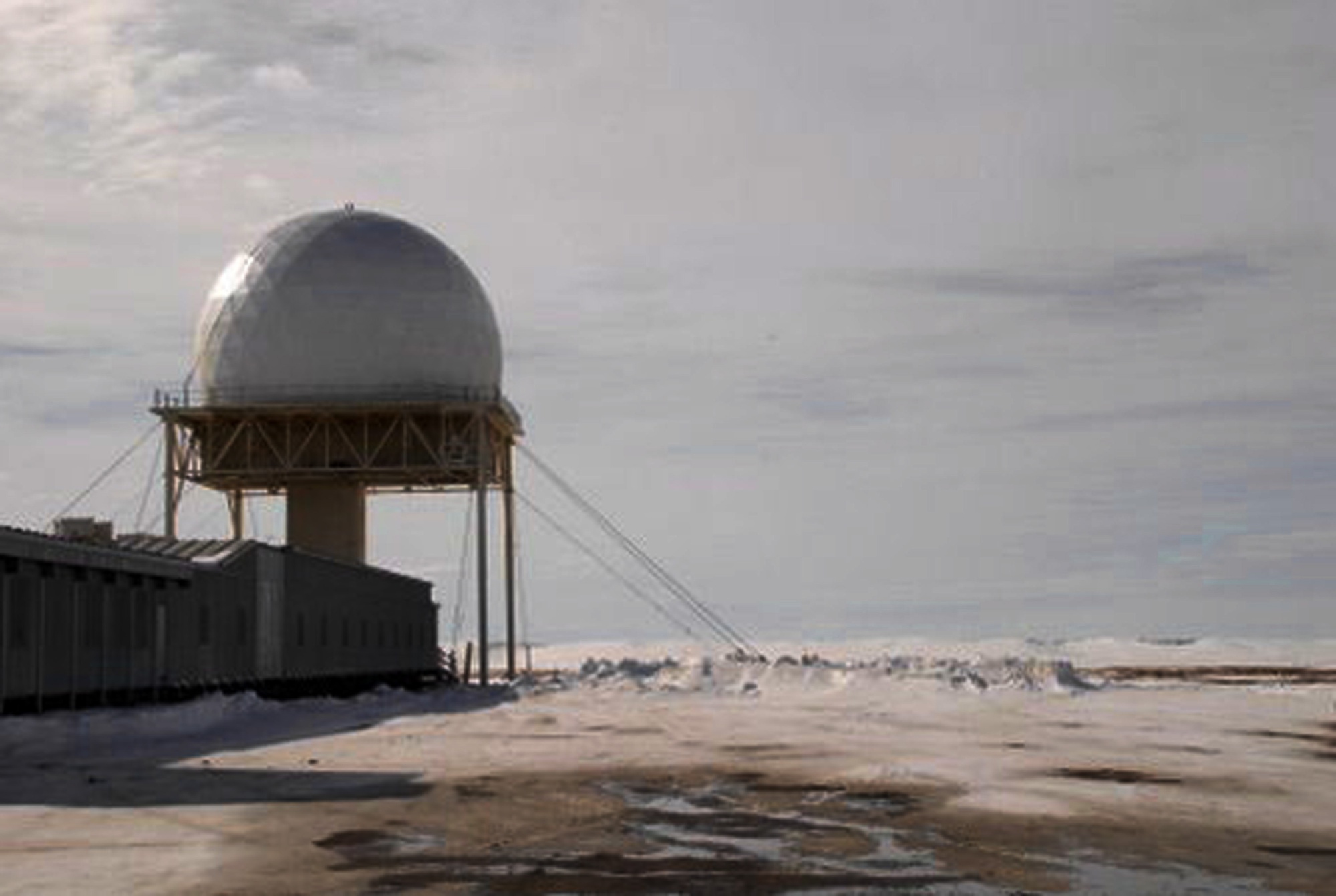
The AN/FPS-19 was the characteristic long-range search radar at many DEW stations. Its two back-to-back reflectors were mounted on one rotating pedestal, often under a rigid radome to withstand Arctic weather. The reflectors were radar antennas. By contrast, White Alice billboards and other radio equipment carried reports and voice traffic; they did not search for aircraft. Some Alaska installations brought those functions together on or near the same property. [1] [3] [4]
Featured Alaska Histories
Start with these Alaska stations, then browse the complete directory below. The six COB stations formed the Aleutian extension identified in the Corps inventory. [4]
Northern coast
Selected Arctic Alaska Stations
- Demarcation Bay BAR-A auxiliary
- Lonely
- Point Barrow
- Wainwright LIZ-3; former DEW auxiliary and short-range radar site
- Point Lay LIZ-2; former auxiliary and long-range radar site
The separate Cape Lisburne Air Force Station also held a DEW Line sector assignment while retaining its longer Aircraft Control and Warning and later radar history. [4]
1959 extension
Aleutian and Peninsula Chain
- Cold Bay COB-Main
- Nikolski COB-1
- Driftwood Bay COB-2
- Cape Sarichef COB-3
- Port Moller COB-4
- Port Heiden COB-5
The Corps identifies AN/FPS-19 radar at each listed COB station and dates this extension's operation from April 1959 to June 1969. [4]
DEW Line Station Directory
The fixed land stations below are arranged by their historical sectors and later extensions. Main and auxiliary sites used rotating search radar; intermediate sites filled gaps between them. Station codes identify places on the DEW network, not separate radar models. The original Arctic line, Aleutian chain and eastern extension opened at different times. [8] [9]
Original Arctic Line: Alaska
LIZ Sector
- LIZ-1 Cape Lisburne AC&W and DEW sector site
- LIZ-A Cape Sabine Intermediate
- LIZ-2 Point Lay Auxiliary; later inactive NWS LRRS
- LIZ-B Icy Cape Intermediate
- LIZ-3 Wainwright Auxiliary; later SRRS
- LIZ-C Peard Bay Intermediate
POW Sector
- POW-M Point Barrow Main
- POW-A Cape Simpson Intermediate
- POW-1 Lonely Auxiliary
- POW-B Kogru River Intermediate
- POW-2 Oliktok Point Auxiliary
- POW-C Point McIntyre Intermediate
- POW-3 Bullen Point Auxiliary
- POW-D Brownlow Point Intermediate
BAR Sector in Alaska
- BAR-M Barter Island Main
- BAR-A Demarcation Bay / Nuvagapak Point Intermediate
The Alaska sector names and station roles are recorded in the DEW Line inventories. Cape Lisburne also has its own Aircraft Control and Warning history. [4] [8]
Original Arctic Line: Canada
BAR Sector in Canada
- BAR-1 Komakuk Beach Auxiliary
- BAR-B Stokes Point Intermediate
- BAR-2 Shingle Point Auxiliary
- BAR-C Tununuk Camp Intermediate
- BAR-3 Tuktoyaktuk Auxiliary
- BAR-D Atkinson Point Intermediate
- BAR-4 Nicholson Peninsula Auxiliary
- BAR-E Horton River Intermediate
PIN Sector
- PIN-M Cape Parry Main
- PIN-A Pearce Point Intermediate
- PIN-1 Clinton Point Auxiliary
- PIN-B Clifton Point Intermediate
- PIN-2 Cape Young Auxiliary
- PIN-C Bernard Harbour Intermediate
- PIN-3 Lady Franklin Point Auxiliary
- PIN-D Ross Point Intermediate
- PIN-4 Byron Bay Auxiliary
- PIN-E Cape Peel Intermediate
CAM Sector
- CAM-M Cambridge Bay Main
- CAM-A Sturt Point Intermediate
- CAM-1 Jenny Lind Island Auxiliary
- CAM-B Hat Island Intermediate
- CAM-2 Gladman Point Auxiliary
- CAM-C Matheson Point Intermediate
- CAM-3 Shepherd Bay Auxiliary
- CAM-D Simpson Lake Intermediate
- CAM-4 Pelly Bay Auxiliary
- CAM-E Keith Bay Intermediate
- CAM-5 Mackar Inlet Auxiliary
- CAM-F Scarpa Lake Intermediate
FOX Sector
- FOX-M Hall Beach Main
- FOX-1 Rowley Island Auxiliary
- FOX-A Bray Island Intermediate
- FOX-2 Longstaff Bluff Auxiliary
- FOX-B Nudluardjuk Lake / West Baffin Intermediate
- FOX-3 Dewar Lakes Auxiliary
- FOX-C Ekalugad Fjord Intermediate
- FOX-4 Cape Hooper Auxiliary
- FOX-D Kivitoo Intermediate
- FOX-5 Broughton Island / Qikiqtarjuaq Auxiliary
- FOX-E Durban Island / Padloping Intermediate
DYE Sector
- DYE-M Cape Dyer Main
The Canadian portion includes main, auxiliary and intermediate sites across the Yukon, Northwest Territories and present-day Nunavut. Some historical station names differ from current place names. [8]
Aleutian and Alaska Peninsula Extension
COB Chain
- COB-M Cold Bay Main
- COB-1 Nikolski Auxiliary
- COB-2 Driftwood Bay Auxiliary
- COB-3 Cape Sarichef Auxiliary
- COB-4 Port Moller Auxiliary
- COB-5 Port Heiden Auxiliary
These six stations became operational as an extension in 1959, after the original Arctic line. [4]
Greenland and Iceland Extension
DYE East
- DYE-1 Qaqqatoqaq, near Sisimiut, Greenland Radar station
- DYE-2 Ice Cap 1, Greenland Radar station
- DYE-3 Ice Cap 2, Greenland Radar station
- DYE-4 Kulusuk, Greenland Radar station
- DYE-5 Rockville, Iceland Eastern link
The four Greenland stations completed the eastern extension; DYE-5 carried the link onward to Iceland. [9]
Early Alaska Experimental Sites
Before the final station pattern was established, the experimental stretch near Barter Island included Collinson Point at Simpson Cove and Aschoff Cape. The 1955 station list names both locations, and Alaska's site records identify Collinson Point as a former intermediate DEW station. [8] [10]
Prototype-Era Locations
- POW-D-2 Collinson Point / Simpson Cove, Alaska Experimental intermediate
- BAR-A-1 Aschoff Cape, Alaska Experimental intermediate
Beyond Alaska
The DEW Line crossed northern Canada and reached Greenland, with later expansion farther into the North Atlantic. Stations on allied territory were integral to a warning mission shared by the United States and Canada. The 1987 map shows that geographic scale, while the directory identifies stations by their own sector codes. [1] [2] [5]
Radar and Communications
Radar
The AN/FPS-19 history explains the dual-channel search set used across much of the line. Other stations had different radar assignments and later replacements. [1] [3]
Communications
Radar warning depended on circuits between stations and command centers. The White Alice hub follows Alaska's related tropospheric-scatter and microwave network, including stations that shared radar properties. [1] [4]
Station Life
At each outpost, power, fuel, shelter and transport made continuous watch possible. The Barter Island history begins with Alaska prototype work and follows that location into its later radar era. [2] [4]
The Next Warning System
The Aleutian extension closed in 1969, but the northern DEW network continued. New radar technology and changed operations eventually led to the North Warning System, constructed in the later 1980s and early 1990s. The successor network uses long- and short-range radar stations for surveillance of the northern approaches. An AN/FPS-117 equipment history traces one of its long-range radar types. The DEW network's replacement by 1993 does not mean that every older radar or installation ended on the same day. [2] [7]
Chronology
- 1952: The MIT summer study recommends an Arctic surveillance and communications line. [1]
- 1953-1954: Experimental work at Barter Island and Alaska prototype radar testing help establish the system. [2] [4]
- July 1957: The original DEW Line is declared operational. [2]
- April 1959: The six-station Aleutian extension becomes operational. [4]
- June 1969: The Aleutian extension closes; the northern DEW network continues. [4]
- 1986-1992: The North Warning System is constructed as the successor northern surveillance network. [7]
- By 1993: The North Warning System replaces the DEW Line as a network. [2]
Information sources (10)
- WEBMIT Lincoln Laboratory
SAGE: Semi-Automatic Ground Environment Air Defense System, DEW Line and early-warning-radar sections.
- WEBAir Force Historical Research Agency
Space Heritage: North America's Polar Shield: The DEW Line, July 28, 2026.
- PDFU.S. Department of Defense
MIL-HDBK-162A, Vol. 1, United States Radar Equipment, December 15, 1965, AN/FPS-19 pages 1-2.
- PDFU.S. Army Corps of Engineers
The Cold War in Alaska: A Management Plan for Cultural Resources, 1994, DEW Line site tables and Aleutian chronology.
- WEBU.S. Air Force
Map, photograph DF-ST-88-03442 by Tech. Sgt. Donald L. Wetterman, February 20, 1987
- WEBU.S. Air Force
Barter Island Radar Site, photograph 090427-F-1735C-148 by 1st Lt. John T. Callahan, April 27, 2009.
- WEBDepartment of National Defence Canada
North Warning System In-Service Support, January 31, 2022.
- PDFDistant Early Warning Coordinating Committee
Minutes and Progress Reports, 1955-63, original station-code schedules and station list, pp. 26-27 and 379-386.
- PDFDistant Early Warning System Operations Handbook
original line and eastern-extension sections, pp. 3-4.
- WEBAlaska Department of Environmental Conservation
Collinson Point DEW Line - Sitewide, hazard ID 1679.