
AN/FPS-78: Laredo Precision Tracking Radar
Type: Fixed VHF precision tracking radar
Manufacturer: General Electric
Service: Laredo Air Force
Station, Texas, 1961-1964
Primary mission: Space-object tracking for SPADATS; temporary missile-detection watch during Falling Leaves
Overview
The AN/FPS-78 was a fixed, mechanically steered, very-high-frequency precision tracking radar built by General Electric for the United States Air Force. Its only confirmed operational installation was at Laredo Air Force Station, Texas. There it formed the tracking half of a two-radar sensor complex with the enormous AN/FPS-17 detection radar. The pairing was intended primarily for satellite and space-object work, but in October 1962 it was diverted into an improvised ballistic-missile warning network during the Cuban Missile Crisis. That emergency mission, called Falling Leaves, made AN/FPS-78 historically important even though the set served at only one known station and remained operational for roughly three years.
The system was neither a conventional rotating air-defense search radar nor a complete ballistic-missile warning installation by itself. Its 60-foot parabolic antenna could be pointed in azimuth and elevation so that operators could follow a selected object and measure its location. A military handbook lists two transmitters, two receivers, a tracker monitor-control console, an automatic digital data processor, and associated air-conditioning equipment. The same handbook gives four transmitting channels between 186 and 207 megahertz and seven receiving channels between 175 and 215 megahertz. Those unusually well documented facts establish the radar's basic physical and radio-frequency identity, while many performance figures often repeated for other Laredo equipment do not belong to AN/FPS-78.
AN/FPS-78 entered its documented operational period during the rapid conversion of experimental tracking facilities into a national space-surveillance network. Rome Air Development Center had operated the Laredo test site before operational and maintenance jurisdiction passed to Air Defense Command on 1 July 1961. By late August the station was functioning under Detachment 1 of the 1st Aerospace Surveillance and Control Squadron, and contemporary reporting described General Electric employees continuing to develop, install, operate, and modify the tracker. This mixed military-contractor environment explains why the radar appears simultaneously as an operational SPACETRACK sensor, a developing technical system, and an emergency warning asset.
During the Cuban Missile Crisis, the United States had no purpose-built continental warning line oriented toward possible launches from Cuba. NORAD therefore assembled Falling Leaves from three unlike sensors: the AN/FPS-49 tracker at Moorestown, New Jersey, the AN/FPS-78 at Laredo, and the AN/FPS-35 search radar at Thomasville, Alabama. Laredo began the missile-detection assignment on 26 October 1962. The network could offer confirmation, rough count, and warning, but it did not transform each participating radar into an equal ballistic-missile computer center. Official accounts specifically state that Moorestown alone had the computing capability needed to calculate launch and impact information.
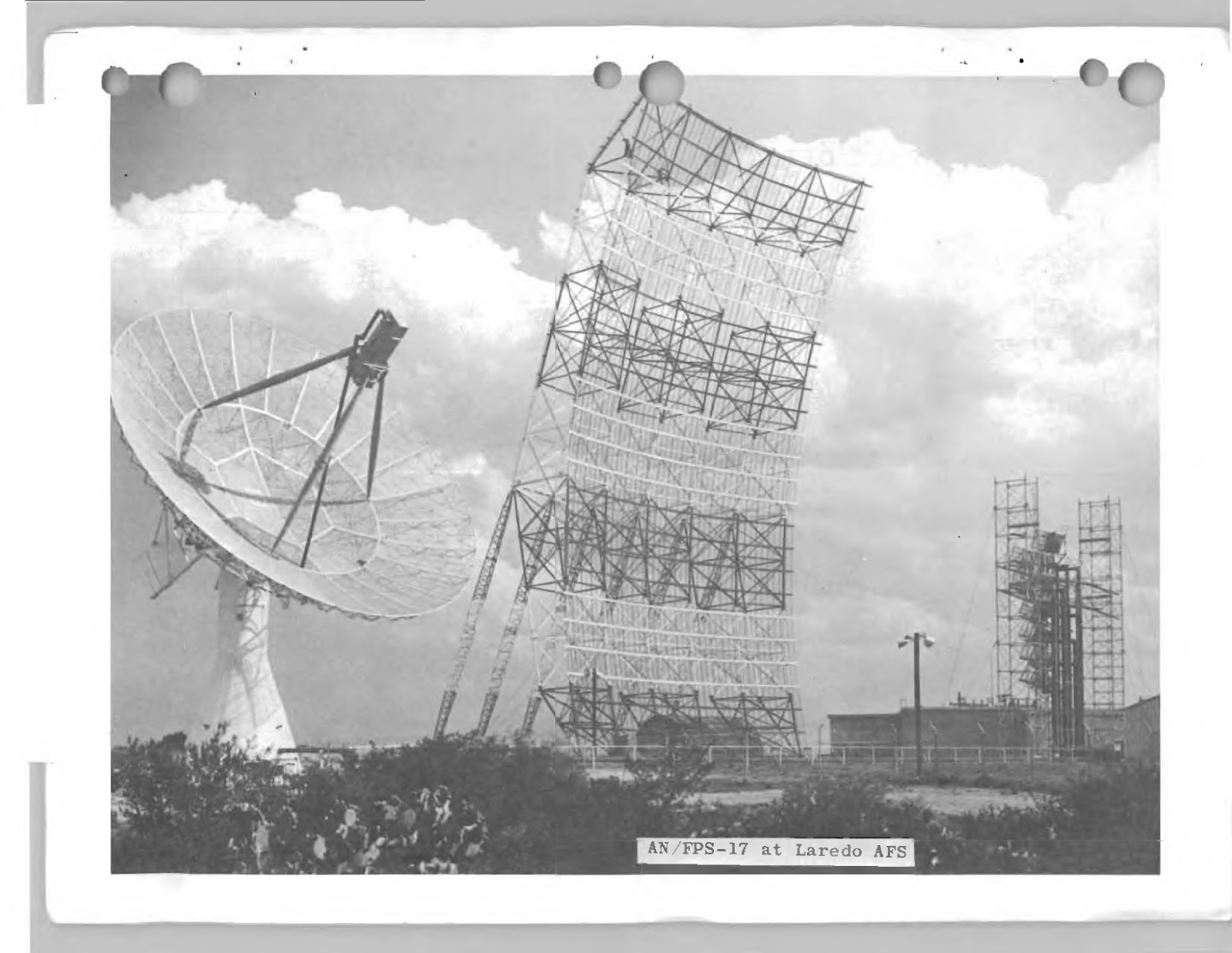
Laredo returned to its primary SPADATS work on 28 November 1962 and continued as a space-surveillance sensor until its deactivation on 15 July 1964. The later installation of AN/FSS-7 submarine-launched ballistic-missile warning equipment at the reactivated Laredo site in 1966 was a new mission and must not be treated as a redesignation or upgrade of AN/FPS-78. No preserved AN/FPS-78 has been confirmed. The most reliable visual evidence remains a period handbook image and a contemporary site photograph showing the broad 60-foot tracking dish beside the fixed AN/FPS-17 structure.
System Identity and Nomenclature
The Joint Army-Navy designation AN/FPS-78 identifies a complete fixed radar set. In that designation, F denotes fixed installation, P denotes radar, and S denotes a detecting or search function under the contemporary nomenclature system. The surviving model sheet in MIL-HDBK-162A (link to PDF in Sources & References section at bottom of page)calls the item simply Radar Set and assigns Federal Stock Number 5840-875-0226. It names General Electric Company's Defense Electronics Division in Syracuse, New York, as manufacturer and cites a nomenclature card dated 18 October 1961. These are stronger identity controls than later unsourced equipment lists or captions.
The official Aerospace Defense Command historical volume contains one misleading entry. Its SPACETRACK facilities table prints the Laredo tracking radar as FFS-78 while correctly identifying the companion detector as FPS-17, marked XW-2. No authenticated FFS-78 model has been found, the prefix is inconsistent with the Joint Electronics Type Designation System, and contemporary NORAD histories repeatedly identify Laredo's tracker as FPS-78. The handbook model sheet independently confirms AN/FPS-78. The ADC table entry is therefore treated as a typographical or transcription error, not as evidence for a separate radar.
The AN/FPS-78 should also be kept distinct from the AN/FPS-17. Photographs of Laredo commonly show both systems in one view, which encourages captions and later summaries to merge their roles. AN/FPS-17 was the fixed detection radar with a very large, essentially stationary antenna structure. AN/FPS-78 was the steerable 60-foot parabolic tracker. Detection supplied notice that an object had entered a monitored region; tracking then followed a selected target to obtain more precise positional data. Equipment values published for AN/FPS-17, including its antenna arrangement, power, beam geometry, and detection performance, cannot be copied into the AN/FPS-78 record.
Nor was AN/FPS-78 the AN/FPS-49 used at Moorestown. Both were precision trackers and both participated in SPADATS and Falling Leaves, but they had different engineering lineages, antennas, frequencies, installations, and data-processing arrangements. The Moorestown radar's associated computer could derive ballistic information that Laredo could not produce on its own during the crisis. Treating all three Falling Leaves radars as one standardized network would erase the central fact that the warning system was improvised from unlike sensors.
Program Origins
Laredo's radar complex grew from the Air Force effort to detect and follow missiles and artificial satellites before space surveillance became a mature operational mission. Rome Air Development Center, an Air Research and Development Command organization, managed experimental sensors and methods that could turn radar observations into usable orbital information. The Soviet launch of Sputnik in October 1957 made that work urgent. Existing research radars at sites such as Millstone Hill, Stanford Research Institute, and Laredo were drawn into Project Harvest Moon and the developing SPACETRACK system because no purpose-built national network yet existed.
Early Laredo work used the AN/FPS-17 as a powerful detection instrument. Its fixed beams could reveal objects passing through selected sectors, but detection alone could not continuously follow a target across the sky. A steerable tracker therefore gave the site an essential second function. Contemporary technical reporting in December 1961 described the large fixed AN/FPS-17 and the 60-foot parabolic tracker beside it, noting that General Electric's Heavy Military Electronics Department had developed, installed, and operated the tracking equipment for the Air Force. The description matches the later AN/FPS-78 handbook sheet in manufacturer, site, antenna size, and function.
The program did not move neatly from development to a frozen production configuration. The December 1961 article said the tracker was being modified for automatic tracking and automatic data handling. The nomenclature card cited by the handbook had been dated only weeks earlier, on 18 October 1961. These details indicate that the designation and the operational system were stabilizing during the same period. The most responsible reconstruction therefore identifies a documented baseline without assuming that every circuit, display, drive, or data path remained unchanged throughout the radar's service.
Rome Air Development Center transferred operational and maintenance jurisdiction over the Laredo and Trinidad test sites on 1 July 1961. At Laredo, Air Defense Command accepted a facility that still depended heavily on contractor expertise. The shift was part of a broader effort to place useful experimental sensors under operational command while technical development continued. It also placed the radar within the command structure that would soon support SPADATS, the Space Detection and Tracking System controlled by NORAD and CONAD.
The Laredo Sensor Site
Laredo Air Force Station occupied a tract northeast of central Laredo and should not be confused with Laredo Air Force Base, the flying installation south of the city. Secondary property research reports a 318.62-acre station acquired beginning in 1955, but the acreage belongs to the installation and not to the AN/FPS-78 equipment footprint. The tracker, detector, operations spaces, power equipment, cooling plant, support buildings, security area, roads, and personnel facilities together formed the site. No reliable source yet divides the tract into radar-specific parcels.
Approximate Laredo Air Force Station site-center reference, WGS 84 decimal degrees: 27.619722, -99.385000 (View on Google Maps). This is a site reference, not an antenna-survey point. It is provided to locate the general complex while avoiding false precision about the AN/FPS-78 pedestal. Published historical feature coordinates and modern map references differ slightly, and no reviewed construction drawing has supplied surveyed antenna coordinates.
The site's south Texas location offered both advantages and limits. Its latitude and clear southern horizon made it useful for observing space objects and for watching approaches from the Gulf of Mexico and Cuba. At the same time, a precision tracker had to be told where to look or be cued by a detector. The companion AN/FPS-17 and the wider SPACETRACK network helped provide that cueing. During Falling Leaves, Laredo's geography made it the southwestern member of a line that extended through Thomasville to Moorestown, improving the chance that more than one sensor could observe an object on a northward trajectory.
Period imagery is essential to understanding the arrangement. The AN/FPS-17 occupied a massive fixed antenna structure that dominated the site, while the AN/FPS-78 appeared as a large open parabolic reflector on a steerable mount nearby. Equipment shelters and service spaces were located around the radar structures. This was not the compact layout of a normal semi-mobile air-defense squadron site. The tracker needed heavy electrical service, cooling, stable foundations, control electronics, and continuous technical attention.
Organization, Personnel, and Contractor Support
By 30 August 1961, Laredo was associated with Detachment 1 of the 1st Aerospace Surveillance and Control Squadron. Secondary research based on local reporting identifies Major Lloyd C. Hill as the officer in charge and describes approximately twenty-six General Electric employees at the station. The exact military and contractor manning tables have not been recovered, so those personnel details should be treated as a period snapshot rather than an authorized strength for the entire service life.
The detachment's mission was operational surveillance and tracking, while General Electric personnel carried much of the specialized engineering and maintenance burden. Such an arrangement was common during the first years of space surveillance, when experimental radars were placed on operational alert faster than the Air Force could create a completely standardized maintenance and training system. Contractors could diagnose transmitter faults, modify automatic tracking circuits, calibrate receivers, and help integrate data equipment while military personnel maintained command, reporting, security, and operational responsibilities.
Laredo's higher organizational relationships changed as space surveillance matured. Rome Air Development Center provided the experimental and technical lineage. Air Defense Command accepted operating jurisdiction in 1961. The 1st Aerospace Surveillance and Control Squadron linked the site to the developing SPACETRACK structure, while NORAD and CONAD exercised command relationships over SPADATS. During the Cuban Missile Crisis, special communications connected Laredo with the NORAD Combat Operations Center, Strategic Air Command headquarters, Air Force command posts, Thomasville, and Moorestown. The radar's value therefore depended as much on disciplined reporting and communications as on the antenna itself.
Mission and Operating Concept
The handbook describes AN/FPS-78's function as determining the presence and location of unknown airborne objects. That broad wording accommodates both satellite tracking and the emergency missile-detection assignment. The radar was designed to point a narrow beam toward a selected object, receive its echo, and keep the antenna aligned as the target moved. Range and angular observations could then be passed to a data system or external center for correlation and orbit work. The set was not designed to sweep all azimuths continuously in the manner of a conventional air-search radar.
In routine SPACETRACK work, cueing information and predicted tracks were central. A detector such as AN/FPS-17 could observe an object crossing a fixed beam, while network predictions could tell the tracker when and where a known satellite should appear. Operators then acquired the target, followed it, checked the observation against predictions, and reported measurements for catalog maintenance. Automatic tracking reduced the burden after acquisition, but it did not eliminate the need for accurate initial pointing, calibration, identification, communications, and human judgment.
The difference between detection and tracking becomes especially important when assessing Falling Leaves. A ballistic missile rising from Cuba would cross the field of view rapidly. A tracker might acquire and follow it if warning, geometry, and readiness aligned, but the radar did not offer broad-area, continuously rotating surveillance by itself. Laredo's companion detector and the other network sites increased the chance of an observation. Even then, the system could provide warning and confirmation only within severe geographic and processing limitations.
Antenna and Mount
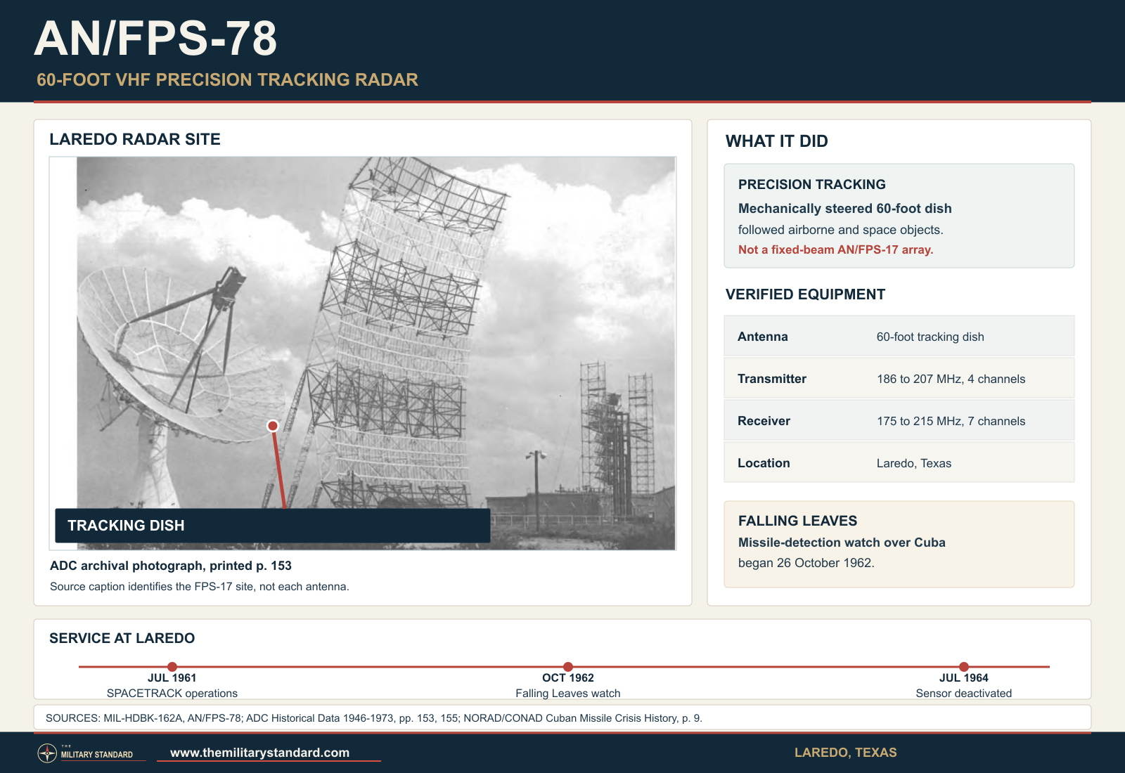
The principal visual feature of AN/FPS-78 was its 60-foot parabolic tracking antenna. The handbook uses that exact diameter and shows a broad open reflector on a heavy pedestal. A contemporary Laredo photograph in Electronics likewise identifies the 60-foot tracker beside the fixed AN/FPS-17. The reflector appears to have open structural backing rather than a solid, featureless dish. The historic photograph above directly shows its curved, open reflector and heavy mounting structure.
The antenna was mechanically steerable in both azimuth and elevation. That capability is inherent in the tracking mission and is visible in the mounting arrangement, but reviewed sources do not publish the maximum angular speed, acceleration, pointing accuracy, travel limits, or minimum elevation. A conventional search-radar rotation rate is not assigned. Describing the antenna as rotating at a search-radar speed would be misleading because it pointed and followed rather than performing a fixed-rate 360-degree scan.
A 60-foot aperture at roughly 175 to 215 megahertz is electrically modest compared with the same physical diameter at microwave frequencies, but it offers useful directivity and collecting area in VHF. Exact beamwidth and gain depend on frequency, illumination, feed, blockage, and reflector efficiency. No authenticated AN/FPS-78 value has been recovered for either parameter. Calculating a theoretical beamwidth from diameter and wavelength could support engineering analysis, but it would not substitute for a published operational specification and is not entered as a confirmed model value.
The feed and polarization arrangement remain unresolved. Period photographs are not yet sharp enough to establish every feed element or support member, and the handbook does not describe polarization. This is a critical visual-control point. A rendering based only on a generic 60-foot dish could easily reproduce the wrong feed, structural depth, yoke, or service platform. The accompanying graphic uses the period photograph rather than an unverified reconstruction.
Frequency and Channel Architecture
MIL-HDBK-162A provides the strongest model-specific radio-frequency data. It lists the transmitter range as 186 to 207 megahertz with four channels and the receiver range as 175 to 215 megahertz with seven channels. These values place the radar in the VHF band. The wider receiving coverage may have supported channel selection, offset reception, monitoring, or operating flexibility, but the handbook does not explain the exact channel plan. The history preserves the printed values without inventing discrete channel frequencies.
The channel arrangement suggests that frequency management mattered to Laredo operations. Two transmitters and two receivers could provide redundancy, alternate operating channels, or specialized tracking modes. Yet the component count alone does not prove simultaneous dual-frequency operation, diversity reception, or a particular duplexing method. Those details require the nomenclature card, technical order, or system block diagrams cited but not reproduced in the handbook.
The frequency must not be confused with the characteristics of AN/FPS-17 or with later AN/FSS-7 equipment at the same installation. Co-location often causes technical data to migrate between models in secondary summaries. The AN/FPS-78 record uses only its handbook ranges. Peak power, pulse width, pulse-repetition frequency, receiver sensitivity, bandwidth, noise figure, and waveform have not been recovered from a model-authenticated source.
Transmitters, Receivers, and Control Equipment
The handbook lists two transmitters and two receivers among the principal components. That is a concrete configuration fact, but it does not identify the internal transmitter type, final amplifier tube, modulator, receiver architecture, intermediate frequency, or display arrangement. The absence of those details should not be filled with values from other General Electric radars. The equipment may have shared corporate design practice with contemporary systems, but similarity is not proof of common hardware.
One monitor-control console is identified as the tracker console. This was presumably the operator interface for acquisition, antenna control, system monitoring, and target following. The precise display scopes, hand controls, servo indicators, and recording devices have not been documented in the reviewed public sources. Contemporary space-tracking work usually combined visual displays with predicted pointing information and communication links, but only a technical manual can establish which functions were internal to AN/FPS-78.
The handbook also lists one automatic digital data processor. That phrase is important because it confirms that digital processing belonged to the documented set configuration. It does not, however, mean Laredo possessed the same ballistic trajectory and impact-prediction capability as Moorestown. Official Cuban Missile Crisis histories state that Moorestown was the only Falling Leaves site with a computer capable of the needed calculations. The most likely explanation is that the AN/FPS-78 processor automated tracking, formatting, or local radar data while Moorestown's separate computing capability performed trajectory analysis. The surviving evidence does not permit a more detailed functional division.
Contemporary reporting said the Laredo tracker was being modified for automatic tracking and automatic data handling in late 1961. This indicates that automatic functions may have entered service in stages. A component listed on the later handbook sheet might describe the mature configuration rather than the first operational arrangement. Acceptance tests, modification orders, and maintenance records are needed to establish when automation became reliable and how operators worked during manual or partially automatic periods.
Power, Cooling, and Site Support
The handbook gives a primary electrical input of 2,400 volts alternating current, three phase, 60 cycles, and 1,000 kilovolt-amperes. It also lists a 208-volt, three-phase, 60-cycle supply without printing a second load figure in the recovered table. The high-voltage service and stated capacity show that AN/FPS-78 was a major fixed installation, not a field radar that could be operated from a small mobile generator. The value is facility input capacity and must not be confused with transmitted radio-frequency power.
An air-conditioning system appears among the principal components. In south Texas, cooling was essential for transmitter rooms, receivers, digital electronics, consoles, and personnel workspaces. Heat removal and humidity control directly affected frequency stability, component life, and operator reliability. The handbook does not give refrigeration tonnage, water requirements, emergency power capacity, or building distribution, so those details remain open research items.
The site also required antenna-drive power, cable runs, grounding, lightning protection, communications, workshops, spare parts, and secured access. None of these supporting systems was glamorous, but radar readiness depended on them. A tracker awaiting a satellite pass could not recover a missed observation caused by a failed drive, overheated cabinet, mistuned receiver, or broken communication circuit. The continued presence of General Electric personnel reflects the maintenance intensity of an early, technically evolving space sensor.
Performance and Unpublished Specifications
No authenticated published source establishes AN/FPS-78 peak radio-frequency power, average radio-frequency power, pulse width, pulse-repetition rate, receiver sensitivity, antenna gain, beamwidth, maximum tracking range, or altitude ceiling. Those performance figures remain unverified. This is a stronger historical result than importing attractive but unsupported numbers from another radar. It defines the boundary between confirmed evidence and future technical research.
Operational range would not have been a single universal number in any case. A radar's ability to follow a target varies with target radar cross section, aspect, range, elevation, propagation, transmitter condition, receiver noise, tracking method, and cue accuracy. A large satellite, a rocket body, and a missile reentry vehicle present different problems. Any future range figure must be tied to a target type, configuration, probability, and source context.
Similarly, the word altitude can mislead when applied to a space tracker. The system followed objects in trajectories and orbits, not aircraft confined to a published service ceiling. Geometry, horizon masking, antenna limits, target visibility, and echo strength governed coverage. No model-specific altitude coverage has been recovered.
SPACETRACK and SPADATS
SPACETRACK began as an Air Force network for detecting, identifying, cataloging, and following artificial satellites and other space objects. It drew observations from dedicated sensors, research facilities, missile ranges, and cooperating organizations. Laredo contributed a combination of fixed detection and precision tracking. That pairing gave the site a role beyond ordinary air defense because observations could improve orbital predictions and help distinguish known objects from new or uncertain ones.
On 7 November 1960, the Joint Chiefs of Staff assigned operational control of the Space Detection and Tracking System to the Commander in Chief, North American Air Defense Command, while Continental Air Defense Command exercised operational command over Air Force elements. By 1963, an official NORAD reference paper listed four assigned radar sites: the AN/FPS-17 and AN/FPS-80 installation at Shemya, the AN/FPS-78 at Laredo, and the ballistic-missile early-warning radars at Clear and Thule. Moorestown and Diyarbakir were identified as cooperating sites. This official roster confirms AN/FPS-78 as a nationally assigned SPADATS sensor.
Laredo's role differed from the polar or overseas sensors. Shemya could observe Soviet missile tests and space objects from the northwest Pacific. Thule and Clear supported early warning and space tracking from high latitudes. Laredo's southern latitude provided geometry useful for objects inaccessible or less favorably viewed from northern stations. The network gained value from these differing locations because multiple observations improved identification and orbit determination.
The site operated during a period when space surveillance was still balancing research, operations, and command authority. Technical centers wanted access for experiments and improvements, while operational commands needed reliable alert performance and standardized reporting. Laredo's transfer from Rome Air Development Center jurisdiction to Air Defense Command did not erase its experimental character. The radar's modifications, contractor presence, and dual mission show how the Air Force turned developmental equipment into an operational network under pressure.
Project Harvest Moon and Early Space Tracking
Project Harvest Moon was an early Air Research and Development Command effort to collect satellite observations using available radar resources. Official Air Force space history identifies Laredo data among the sources used with Millstone Hill and Stanford Research Institute observations. This establishes the site's participation in the pre-operational space-tracking effort, but the available account does not explicitly assign every Harvest Moon observation to AN/FPS-78. Some early Laredo work may have depended on AN/FPS-17 or a developing tracker configuration.
That distinction matters for chronology. The Laredo site had an experimental history before AN/FPS-78's documented 1961 operational identity. It would be tempting to make the tracker retroactively responsible for every earlier space observation. The evidence instead supports a careful sequence: Laredo served as a research sensor location; the 60-foot tracker was developed and installed by General Electric; the set received the AN/FPS-78 designation by October 1961; and the operational site then became an assigned SPADATS element.
Mercury-Atlas 6 Claim
Local and specialist histories report that Laredo's AN/FPS-78 tracked John Glenn's Mercury-Atlas 6 spacecraft on 20 February 1962. The claim is plausible because the radar was operational, Laredo had a space-tracking mission, and the flight made three Earth orbits. It is also historically attractive because it connects the site to the first American orbital mission flown by an astronaut. Plausibility, however, is not equivalent to documentary confirmation.
NASA's Mercury-Atlas 6 mission material describes a worldwide tracking network using C-band and S-band radars, telemetry, communications, and computing support. The reviewed NASA technical report does not identify AN/FPS-78 or Laredo as a mission-network radar. Laredo may have tracked the spacecraft as a SPACETRACK observation outside NASA's primary flight-control network, but that relationship needs a mission log, station report, or contemporary newspaper image with sufficient detail. The history therefore preserves the claim as locally reported and unconfirmed rather than presenting it as established NASA support.
The Cuban Missile Crisis
In October 1962, photographic intelligence revealed Soviet offensive missiles in Cuba. The discovery exposed a continental warning gap. Existing ballistic-missile early-warning radars faced generally northward routes from the Soviet Union, not short trajectories from Cuba toward the United States. Air Defense Command and NORAD had to construct an emergency warning arrangement from sensors that had been designed for other purposes.
The resulting operation was named Falling Leaves. The AN/FPS-49 at Moorestown, New Jersey, began the Cuban missile-detection assignment on 24 October. Laredo's AN/FPS-78 followed on 26 October, and the AN/FPS-35 at Thomasville, Alabama, joined on 30 October. Special communications connected the three stations with one another and with command posts. Geography gave the line a rough southwest-to-northeast orientation across possible flight paths, but the radars' different designs prevented the network from behaving like a standardized warning system.
Official Air Force history places the network in operation on 27 October, the most dangerous day of the crisis, while the site-specific record gives Thomasville's later start on 30 October. These statements can coexist if 27 October marks the initial Moorestown-Laredo warning arrangement and 30 October marks completion of the three-site configuration. The history does not force one date to replace the other because they describe different stages of emergency activation.
Laredo's normal SPADATS mission was interrupted by the new task. A 1962 NORAD history notes that Moorestown and Laredo were withdrawn from SPADATS work for the Cuba-oriented operation, creating a space-surveillance shortfall. The Trinidad tracker was called upon for additional SPADATS support, although staffing allowed only two-shift operation. The episode shows that the United States had limited specialized sensor capacity: assigning a tracker to missile warning meant accepting reduced coverage elsewhere.
Falling Leaves Operations
Falling Leaves depended on rapid voice reporting and human interpretation. If one radar observed a suspicious object, the other sites and command centers had to compare detections with known satellite predictions and other information. Moorestown's computer gave it a unique ability to calculate trajectory and estimate launch and impact points. Laredo and Thomasville could contribute warning, confirmation, and an approximate count, but they could not independently provide the same predictive solution.
The distinction prevents a common historical overstatement. AN/FPS-78 was used for missile detection, but that emergency use did not make it a complete missile-warning radar in the later AN/FSS-7 or phased-array sense. Its tracker could observe and follow a target within favorable geometry. The network around it supplied cueing, communications, comparison, and computation. Falling Leaves was a system-of-systems assembled through urgency, not a new performance specification for AN/FPS-78.
The official Air Force crisis study describes three significant events after activation. Thomasville observed three objects that proved not to be missiles. Moorestown experienced a false alarm associated with a test tape. Near midnight, Laredo reported an object that Moorestown identified as a satellite. These incidents show why warning reliability depended on correlation. A radar return could be technically real while its interpretation was operationally wrong. The network had to discriminate between missiles, satellites, tests, and other targets under extreme political pressure.
The Laredo satellite incident is especially revealing. AN/FPS-78 was doing what a tracker could do: observe an object and report it. Moorestown's data and computing context allowed the network to classify that object as a satellite. The event was not simply a radar failure. It demonstrated both the sensor's utility and the danger of using an improvised network without fully integrated identification and prediction at every site.
Strategic Air Command assessed Falling Leaves as inadequate in performance, coverage, and reliability for a permanent warning requirement. Even so, a limited and imperfect warning line was preferable to having no Cuba-oriented detection arrangement during the crisis. Moorestown could offer Strategic Air Command headquarters approximately eight minutes of warning under favorable circumstances, while Laredo and Thomasville added confirmation and count information. The system's historical importance lies in that emergency adaptation and in the operational lessons it exposed.
Communications and Command Relationships
The communications network linked the radar sites with the NORAD Combat Operations Center, Air Force command elements, and Strategic Air Command. Voice circuits were essential because data systems and formats were not standardized across the three radars. Operators had to transmit observations quickly, repeat uncertain information, and compare reports. A delay of even a few minutes would consume a large part of the warning time available for a missile launched from Cuba.
Command relationships were equally important. NORAD and CONAD coordinated continental warning and defense, Air Defense Command operated the participating Air Force sensors, and Strategic Air Command needed warning to protect nuclear forces and national command functions. Falling Leaves therefore crossed organizational boundaries as well as equipment boundaries. The crisis forced technical data, operational judgments, and command decisions into one compressed process.
The radar crews and contractor technicians worked under conditions in which false alarms could have strategic consequences. System readiness involved more than keeping the transmitter on the air. Operators needed current satellite predictions, authenticated tests, disciplined reporting phrases, and a clear path for resolving ambiguous tracks. The test-tape incident at Moorestown demonstrated how training or maintenance activity could enter an operational channel if procedural barriers failed.
Return to SPADATS
On 28 November 1962, Moorestown and Laredo were released from the special Cuba-oriented assignment and returned to their primary SPADATS missions. Official history notes that Laredo returned without specific recall capability, indicating that the emergency arrangement was not simply left dormant as a ready secondary mode. Thomasville continued the Falling Leaves watch for approximately thirty more days before it too resumed its normal role.
The return reflected both reduced crisis conditions and the cost of withholding specialized trackers from space surveillance. The Air Force could not sustain the emergency diversion indefinitely without weakening SPADATS. This tradeoff reinforced the need for dedicated south-looking missile-warning equipment. In later years, the AN/FSS-7 system met that requirement at several coastal sites, including the reactivated Laredo installation.
The crisis also provided operational evidence about warning architecture. Broad detection coverage, precise tracking, trajectory computation, reliable communications, and identification data had to function as an integrated system. Distributing those functions among three unlike radars created delays and ambiguities. Later warning networks sought greater automation and purpose-built coverage rather than depending on temporary alignment of experimental and air-defense sensors.
Post-Crisis Service
After Falling Leaves, AN/FPS-78 resumed satellite and space-object tracking. The surviving public histories give less detail about routine observations than about the crisis, but official SPADATS rosters continue to identify Laredo as an assigned radar site. Its work would have included scheduled acquisition, tracking, reporting, and support to the space-object catalog. The site's latitude remained valuable, while the companion AN/FPS-17 and network cueing helped place targets within the tracker's field of regard.
Routine service likely remained technically demanding. Automatic tracking and data handling reduced some operator workload, yet calibration, prediction errors, target acquisition, servo performance, and transmitter reliability still required attention. Contractor support probably continued in some form, but exact staffing and contract dates have not been recovered. No source reviewed provides a complete list of satellites, missile tests, or research experiments tracked by AN/FPS-78.
The radar's short life must be understood in the context of rapidly advancing space-surveillance technology. Sensors designed or adapted at the beginning of the space age could become operationally limited within a few years as target counts increased and catalog accuracy demands grew. A single mechanically steered tracker also had limited capacity: while following one object it could not simultaneously observe many others. New dedicated radars and improved network processing gradually reduced dependence on early one-of-a-kind systems.
Deactivation On 15 July 1964
The Laredo sensor was deactivated on 15 July 1964. This exact date appears in the ADC SPACETRACK facilities table and is confirmed in the official NORAD and CONAD history for the second half of 1964. The date should be treated as the end of the radar site's operational SPADATS role.
The available public record does not identify the AN/FPS-78's final track, the date its transmitter last operated, the disposition of each component, or the formal property-accounting date for the set. A station deactivation date can differ from the last operational shift and from the later removal of equipment. The documented site deactivation on 15 July 1964 is the best supported retirement milestone, while detailed shutdown and disposal records remain missing.
Deactivation did not end the military significance of the Laredo property. The national requirement for warning against submarine-launched ballistic missiles led to a new mission. The station was reactivated on 1 April 1966 for AN/FSS-7 operations. That later radar used different technology and served a different warning architecture. Any buildings, power distribution, security features, or utility systems reused from the earlier station were site-level continuities, not proof that AN/FPS-78 remained in service.
Relationship to AN/FSS-7
AN/FSS-7 was a fixed ballistic-missile detection radar developed for surveillance of approaches from the sea. Its deployment at Laredo followed lessons made visible by the Cuban Missile Crisis, but it was not a modification of AN/FPS-78. The two systems differ in designation, equipment architecture, mission design, and chronology. AN/FPS-78 had already ended its documented operation in 1964, while the reactivated warning site began in 1966.
The temptation to describe AN/FSS-7 as the direct replacement is understandable because it occupied the same installation and addressed a related warning problem. A more precise statement is that AN/FSS-7 succeeded AN/FPS-78 at the site and in part of the southern warning mission, but no evidence establishes a one-for-one technical replacement. National space-surveillance work continued through other sensors, while the new Laredo mission emphasized missile detection.
This distinction also controls photographs. An image of the reactivated station may show AN/FSS-7 structures, surviving AN/FPS-17 elements, or altered support buildings rather than AN/FPS-78. Every photograph must be dated and its equipment identified before it is used to reconstruct the tracker. Site continuity alone is not visual authentication.
Deployment Record
Only one AN/FPS-78 installation is confirmed: Laredo Air Force Station, Texas. The handbook does not list a production quantity, and no official source reviewed identifies a second operational set. This one-site record is consistent with the radar's experimental-to-operational lineage and its role as part of the unique Laredo AN/FPS-17 complex.
The designation should not be added to Moorestown, Thomasville, Trinidad, Shemya, or other SPADATS sites simply because those stations worked with Laredo. Moorestown used AN/FPS-49, Thomasville used AN/FPS-35 for Falling Leaves, Trinidad used a large precision tracker identified in official NORAD histories as AN/FPS-44, and Shemya used AN/FPS-17 and AN/FPS-80. Network association does not imply common equipment.
No mobile, transportable, or foreign deployment has been confirmed. The 2,400-volt, 1,000-kilovolt-ampere power requirement, 60-foot antenna, fixed designation, and site photographs all support a permanent installation.
Facilities and Physical Support
The AN/FPS-78 required a reinforced antenna foundation and mount, transmitter and receiver rooms, a control area, a digital-processing space, electrical distribution, cooling, maintenance access, and communications. The handbook's component list confirms the core technical elements but not their building-by-building placement. Period site photography suggests substantial equipment structures adjacent to the radar, yet no reviewed floor plan assigns each room to a particular function.
The station also needed ordinary military support. Administration, security, roads, utilities, fire protection, storage, and personnel services allowed the technical mission to continue around the clock. Contractor employees required workspace and access controls. These support functions belonged to Laredo Air Force Station rather than to the radar set itself, but they were operationally inseparable from radar readiness.
The wider 318.62-acre figure reported by secondary property research may include buffer land, support facilities, access, and later mission areas. It must not be used as the size of the radar compound. A property map, acquisition tract schedule, or real-estate disposal plan is needed to define the exact boundaries of the 1961 to 1964 AN/FPS-78 operating area.
Role In the Wider Military Network
AN/FPS-78 linked three military problems that are often studied separately: early space surveillance, continental air and missile warning, and research-to-operations transition. Within SPADATS, Laredo supplied geographically valuable tracking data to a network of assigned and cooperating sensors. During the Cuban Missile Crisis, the same tracker became one component of an emergency south-looking warning line. In both missions, its observations had value only when communications, prediction, correlation, and command centers turned them into decisions.
The radar also illustrates the limited capacity of the early network. When Laredo and Moorestown were reassigned to Falling Leaves, Trinidad had to provide additional space-tracking coverage. The United States could not simply add a new software task to abundant sensors. It had to choose which national mission a scarce tracker would serve at a given time. This operational competition accelerated the case for more dedicated and automated equipment.
Laredo's companion AN/FPS-17 supplied a local detection relationship, but national performance depended on distant sites. Moorestown contributed unique computing, Thomasville contributed a different search geometry, Trinidad helped cover SPADATS work, and NORAD's Combat Operations Center coordinated reporting. Strategic Air Command was a key consumer of missile warning. The network was therefore both technical and institutional, extending far beyond the Laredo fence line.
Technological Significance
The AN/FPS-78 represents a transitional generation of space radar. Its large mechanically steered reflector and high-power fixed plant belonged to the era before electronically steered phased arrays could search and track many objects rapidly. At the same time, its automatic tracker and digital data processor pointed toward the increasing automation that space surveillance required. The set combined mature radar principles with emerging digital control in a one-of-a-kind operational installation.
Its VHF operating range also distinguished it from many microwave precision trackers. VHF offers different propagation, antenna-size, resolution, and target-response characteristics. The 60-foot dish supplied directivity that would have required a much smaller aperture at higher frequency. Without the technical order, it is not possible to state why the final channel range was selected, but the design must be evaluated on its own frequency and mission rather than by analogy to S-band or C-band trackers.
Falling Leaves demonstrated that technological capability is not identical to operational suitability. AN/FPS-78 could observe space objects and could be aimed toward a missile-threat corridor. It lacked the broad coverage and integrated trajectory computation needed for a robust warning network. The crisis use was successful as an emergency expedient because people connected multiple imperfect assets, not because one radar suddenly acquired capabilities it had never been designed to provide.
Retirement, Disposition, and Preservation
No complete preserved AN/FPS-78 has been confirmed. Later imagery of the Laredo property does not establish survival of the 60-foot tracker, and the site changed substantially for AN/FSS-7 operations and subsequent uses. A preserved foundation, building, or cable feature would be evidence of the installation but not a preserved radar set. Authentication requires comparison with dated photographs, engineering plans, and property records.
Federal property and environmental records identify the former Laredo tracking site in later cleanup and transfer contexts. Those records are important for the installation's post-military history, but they do not identify which contaminants, structures, or parcels belonged specifically to AN/FPS-78. Radar operations could involve fuels, oils, solvents, transformers, batteries, and maintenance chemicals, yet no reviewed source supports assigning a particular environmental condition to this model.
The tracker's disappearance reflects the fate of many early space sensors. Large structures were expensive to maintain after operational use ended, electronics became obsolete quickly, and later missions required different layouts. Unless a component was deliberately transferred to a museum or technical collection, demolition and disposal were more likely than preservation. No accession record has yet been found for an AN/FPS-78 antenna, console, transmitter, receiver, or data processor.
Technical Summary
- Designation
- AN/FPS-78
- Primary role
- Fixed precision tracking of space and airborne objects; assigned SPADATS satellite tracking; temporary Falling Leaves missile detection
- Manufacturer
- General Electric Company, Defense Electronics Division, Syracuse, New York; contemporary account credits General Electric Heavy Military Electronics Department with development, installation, and operation
- Confirmed installation
- Laredo Air Force Station, Texas
- Frequency band
- VHF
- Transmitter frequency
- 186 to 207 megahertz, four channels
- Receiver frequency
- 175 to 215 megahertz, seven channels
- Principal radio-frequency components
- Two transmitters and two receivers
- Antenna
- 60-foot mechanically steered parabolic tracking antenna
- Control and processing
- One monitor-control tracker console and one automatic digital data processor
- Power
- 2,400 volts alternating current, three phase, 60 cycles, 1,000 kilovolt-amperes; additional 208-volt, three-phase, 60-cycle service listed without a recovered load figure
- Cooling
- One air-conditioning system listed as a principal component
- Peak power
- Not publicly established in a model-authenticated source
- Average radio-frequency power
- Not publicly established
- Pulse width and pulse-repetition frequency
- Not publicly established
- Gain and beamwidth
- Not publicly established
- Range and altitude coverage
- Target, geometry, and configuration dependent; no model-specific published values recovered
- Documented operational period
- July 1961 to 15 July 1964
- Emergency mission
- Falling Leaves, beginning at Laredo on 26 October 1962
- Direct replacement
- None confirmed; AN/FSS-7 was a later site and mission successor, not an AN/FPS-78 modification
- Preservation
- No complete example confirmed
Chronology
- 1955 The Air Force began acquiring land for the Laredo radar and tracking installation northeast of the city; the exact relationship of each tract to the later AN/FPS-78 area requires a property map.
- 1956 The Laredo test site entered operation with early missile and space-detection work centered on the AN/FPS-17 complex.
- 4 October 1957 Sputnik 1 entered orbit, increasing the urgency of United States satellite detection, identification, and tracking programs.
- 1958 Secondary property research reports completion of the principal Laredo land purchase on 23 October; the installation acreage is not an AN/FPS-78 equipment footprint.
- 1958 to 1960 Project Harvest Moon used observations from Laredo and other research radars to support early Air Force space tracking.
- 7 November 1960 The Joint Chiefs of Staff assigned CINCNORAD operational control of SPADATS, with CONAD exercising operational command over participating Air Force elements.
- 1960 to 1961 General Electric developed, installed, and operated the 60-foot Laredo tracker for the Air Force while the system moved from experimental work toward an operational role.
- 1 July 1961 Operational and maintenance jurisdiction over the Laredo and Trinidad test sites transferred from Rome Air Development Center.
- By 30 August 1961 Detachment 1, 1st Aerospace Surveillance and Control Squadron, was operating at Laredo; period reporting also described a substantial General Electric contractor presence.
- 18 October 1961 The nomenclature card later cited by MIL-HDBK-162A was dated, providing a documentary anchor for the AN/FPS-78 designation.
- 1 December 1961 Electronics published a contemporary account and photograph of the 60-foot General Electric tracker at Laredo, reporting modification for automatic tracking and data handling.
- 20 February 1962 Mercury-Atlas 6 carried John Glenn on three Earth orbits; local histories report AN/FPS-78 participation, but reviewed NASA mission documents do not yet confirm the claim.
- Early 1962 AN/FPS-78 continued space-object tracking as the Laredo element of the developing SPACETRACK and SPADATS network.
- 14 October 1962 United States reconnaissance photographed Soviet offensive missile installations in Cuba, beginning the intelligence sequence that produced the crisis.
- 22 October 1962 President John F. Kennedy publicly announced the Soviet missile deployment and the United States naval quarantine.
- 24 October 1962 The AN/FPS-49 at Moorestown began the Falling Leaves Cuban missile-detection mission.
- 26 October 1962 AN/FPS-78 at Laredo began missile-detection operation for Falling Leaves.
- 27 October 1962 Official Air Force history describes the initial emergency radar network as operational during the most dangerous day of the crisis.
- 30 October 1962 AN/FPS-35 at Thomasville joined the Falling Leaves mission, completing the three-site arrangement.
- Late October 1962 Voice circuits linked Laredo, Moorestown, Thomasville, NORAD, Air Force, and Strategic Air Command command posts.
- Late October 1962 Laredo reported an object that Moorestown identified as a satellite, demonstrating the need for network correlation and computing.
- Late October 1962 Thomasville observed three non-missile objects and Moorestown experienced a test-tape false alarm, further demonstrating interpretation and procedural risks.
- October to November 1962 Laredo and Moorestown were diverted from primary SPADATS work, and Trinidad was asked to cover part of the resulting space-surveillance shortfall.
- 28 November 1962 Laredo and Moorestown returned to their primary SPADATS missions; Laredo returned without specific Falling Leaves recall capability.
- December 1962 Thomasville continued the Cuban warning watch for about thirty additional days after Laredo and Moorestown were released.
- 1963 An official NORAD reference paper listed AN/FPS-78 at Laredo among four assigned SPADATS radar sites.
- 1963 Laredo continued scheduled space surveillance and tracking within a network that also used assigned and cooperating sensors in Alaska, Greenland, Turkey, New Jersey, and elsewhere.
- 1963 to 1964 The growing space-object population and expanding dedicated sensor network reduced the long-term utility of early one-of-a-kind tracking installations.
- 15 July 1964 The Laredo sensor site was deactivated, ending the documented AN/FPS-78 operational period.
- Second half of 1964 NORAD and CONAD historical reporting recorded the Laredo deactivation as part of SPADATS network changes.
- 1965 MIL-HDBK-162A incorporated the AN/FPS-78 model sheet, preserving technical data even though Laredo operations had ended.
- 1 April 1966 Laredo was reactivated for the AN/FSS-7 submarine-launched ballistic-missile warning mission, a separate system and not a continuation of AN/FPS-78.
- Late 1960s Later Laredo imagery and documentation increasingly reflect the AN/FSS-7 mission rather than the removed AN/FPS-78 tracker.
- 1974 Later property history indicates transfer of portions of the former Air Force station to the United States Army; parcel details require confirmation.
- Post-Cold War period Former Laredo tracking-site property appeared in federal environmental and property-review records.
- 2026 No complete preserved AN/FPS-78 had been confirmed through the reviewed official, archival, museum, or specialist sources.
Information sources (19)
- PDFMIL-HDBK-162A, Military Standardization Handbook, United States Radar Equipment
Primary equipment specification for the GE manufacturer, VHF channel ranges, component counts, 60-foot antenna, electrical input, and nomenclature-card date.
- PDFADC Historical Data, 1946-1973
Official ADC source for the historic Laredo photograph and SPACETRACK site relationships.
- WEBNORAD/CONAD Participation in the Cuban Missile Crisis, Historical Reference Paper No. 8
Official NORAD account of the three Falling Leaves radars, start dates, communications, and Moorestown computing distinction.
- PDF1962 NORAD/CONAD History, July through December
Contemporary NORAD operational chronology and Cuban Missile Crisis context.
- PDF1964 NORAD/CONAD History, July through December
Official record of the Laredo sensor deactivation on 15 July 1964.
- PDFSeventeen Years of Air Defense, NORAD Historical Reference Paper No. 9
Official NORAD reference identifying Laredo among assigned SPADATS radar sites.
- PDFForty Years of Research, Development, Test, and Evaluation
Rome Air Development Center program and research-site lineage.
- PDFBeyond Horizons: A Half Century of Air Force Space Leadership
Air Force space-program background and the transition from research sensors to operational surveillance.
- WEBUnited States Air Force Space Surveillance, 1957-2007
Air Force account of early space surveillance, SPACETRACK, and SPADATS.
- PDFTrinidad and Texas Radars Hunt Satellites
Contemporary technical reporting and photograph of the 60-foot General Electric tracker at Laredo.
- PDFThe Air Force Role in Five Crises, 1958-1965
Air Force history of the Cuban Missile Crisis warning response.
- PDFStrategic Air Command and the Cuban Missile Crisis of 1962
Strategic Air Command crisis context and communications relationships.
- WEBSearching the Skies: The Legacy of the United States Cold War Defense Radar Program
Air Force-sponsored historic context for early radar and air-defense equipment.
- WEBMercury-Atlas 6
NASA mission chronology used to assess, but not verify, the reported Mercury-Atlas 6 connection.
- WEBResults of the First United States Manned Orbital Space Flight, February 20, 1962
NASA technical report consulted for Mercury-Atlas 6 tracking-network evidence; it does not confirm AN/FPS-78 participation.
- WEBLaredo Air Force Station
Secondary local-site synthesis used only for clearly qualified land, personnel, and property details.
- PDFEnvironmental Contamination: Cleanup Actions at Formerly Used Defense Sites
Federal property and environmental context for the former Laredo tracking site, not model-specific contamination.
- WEBThe Limits of Safety: Organizations, Accidents, and Nuclear Weapons
Historiographical comparison where secondary equipment identification differs from official records.
- WEBNational Archives Catalog Search for AN/FPS-78
Archival discovery route for additional model-specific records; search results are not evidence of a surviving set.