
Soldotna Radio Relay Station, Alaska
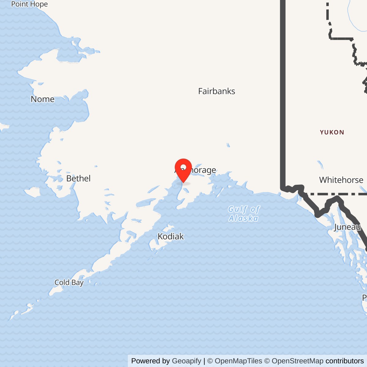
Longitude: -151.083333
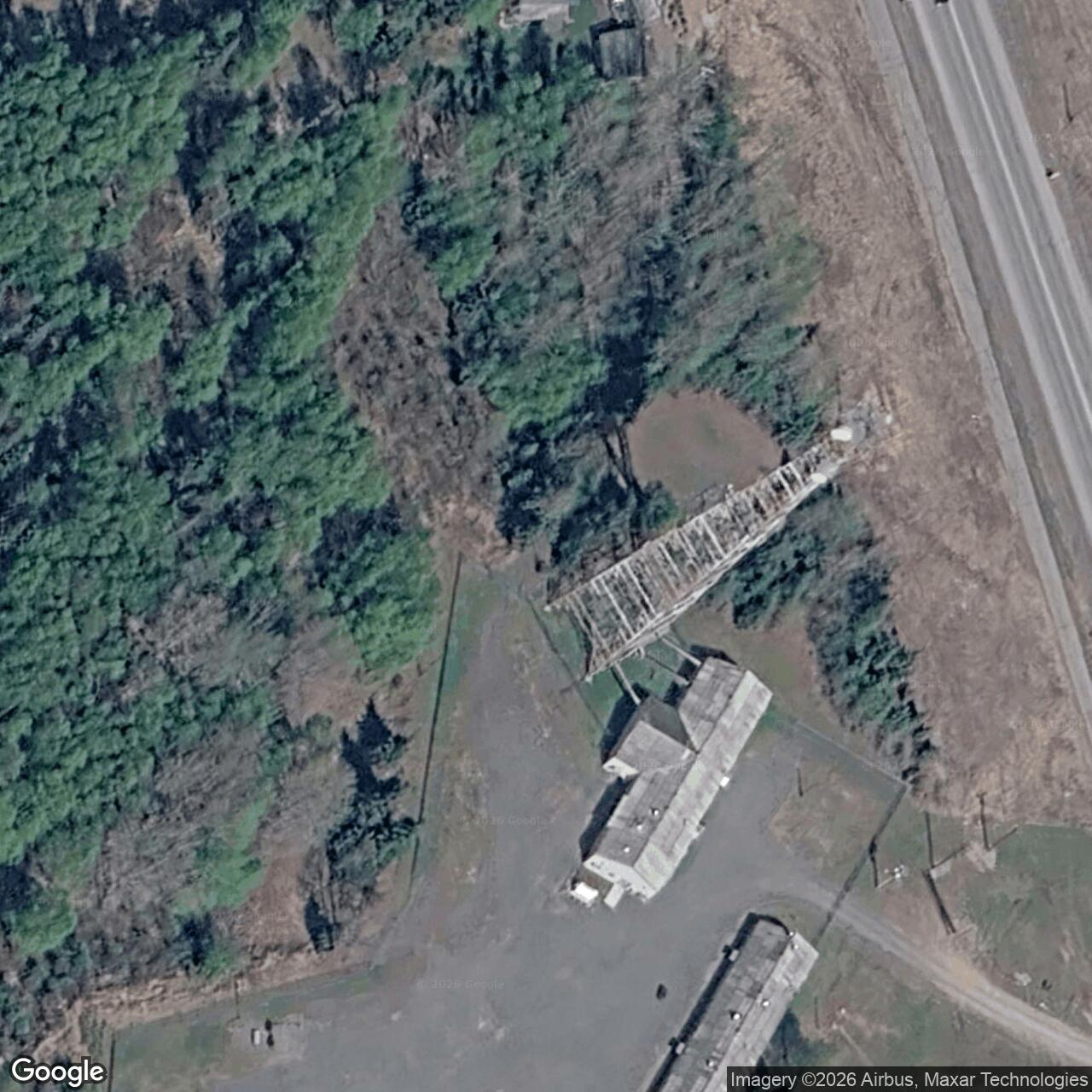
Soldotna was an attended communications station on the Kenai Peninsula route of Alaska's White Alice Communications System. Unlike its smaller, unattended microwave neighbors, it had a substantial equipment building, a twelve-person dormitory, a maintenance shop, and on-site fuel and water facilities. The station carried TD-2 microwave traffic north to Naptowne and south to Clam Gulch. A 1988 U.S. Army Corps of Engineers inventory says the microwave station opened in 1957 and records an actual historical photograph of its tower. A 1994 Corps plan instead dates establishment of the White Alice facility to 1958 and says the site also had two tropospheric-scatter antennas. Those accounts describe a developing installation, but the exact date of the troposcatter addition has not been independently established. The station later became an Alascom communications property. The historical buildings were still central to a 2025 environmental investigation; the Alaska Department of Environmental Conservation (DEC) continued to list the associated contamination case as active when reviewed in October 2026.
- Role
- Attended original White Alice TD-2 microwave relay at an earlier Army communications parcel; later also had two troposcatter antennas.
- Opening
- 1988 Corps inventory: 1957. A 1994 Corps plan says the White Alice facility was established in 1958.
- Verified route
- Naptowne, approximately 17 miles north; Clam Gulch, approximately 26 miles south.
- Historic plant
- 4,550-square-foot equipment building, 4,580-square-foot twelve-person dormitory, shop, water-control building, TD-2 tower, and fuel storage.
- Location point
- 60.531667 N, 151.083333 W (NAD83), DEC environmental-site GIS point, not a surveyed historic tower, compound centroid, or property boundary.
- Later status
- Alascom use verified in 1988 and 1994. DEC environmental case still listed Active at this audit; current radio operation and historic antenna survival unverified.
Identity And Location
The station is a distinct installation, not the city of Soldotna, Kenai Airport, or either neighboring White Alice repeater. The 1988 Corps inventory uses "Soldotna (Kenai)," while the 1983 Air Force study sometimes calls the TD-2 station "Kenai." In this context those are alternate labels for the Soldotna installation. The study locates the attended station about three miles north of the Sterling Highway and eight miles south of Kenai; its road description says a good gravel road led to the station. The modern DEC record calls the same communications property "AT&T Alascom Soldotna Microwave" at 44890 Churchill Avenue, Mile 3.5 Kenai Spur Highway, Kenai, Alaska. The place names and road references should not be mistaken for separate installations or proof that the facility stood in downtown Soldotna.
DEC supplies a site/GIS point at approximately 60.531667 N, 151.083333 W, datum NAD83. Its 2005 entry says the point was selected from a 1999 preliminary-assessment figure, maps, aerial photography, and parcel lookup. This is a mapped environmental-site location, not a surveyed 1950s tower footing, historical compound centroid, legal parcel corner, or contaminated-groundwater boundary. The April 2025 groundwater report describes essentially the same approximate location in degrees, minutes, and seconds and gives an elevation of about 167 feet. A 2010 FCC public notice gives a nearby Alascom WOE33 radio-license point of approximately 60.532222 N, 151.083333 W. The FCC and DEC points differ by roughly 62 meters north-south; they represent different records, not evidence for a second Soldotna White Alice station.
Army Communications Predecessor And White Alice Role
The 1994 Corps plan states that the microwave facilities at Anchorage and Soldotna were placed at former communications stations. Its contrast with four purpose-built, standardized Kenai microwave repeaters matters: Soldotna was an expansion of an earlier Army Alaska Communications System location, rather than simply another small concrete-block repeater copied from one plan. The surviving sources do not establish the predecessor station's first opening day, initial building list, unit roster, or exact transfer date.
White Alice was designed to move military and civilian communications across Alaska's huge distances and difficult terrain. The original system combined line-of-sight microwave paths and tropospheric-scatter links. Soldotna appears in the original 31-site inventory as a microwave station. The Corps' 1994 field account documents both its microwave relay and two troposcatter antennas, so the site should not be described as exclusively TD-2 throughout its life. Conversely, neither source identifies a specific operational partner for each of Soldotna's troposcatter antennas; drawing an invented tropo route would be misleading. It was a communications relay, not an aircraft-search radar, warning squadron, or fighter base.
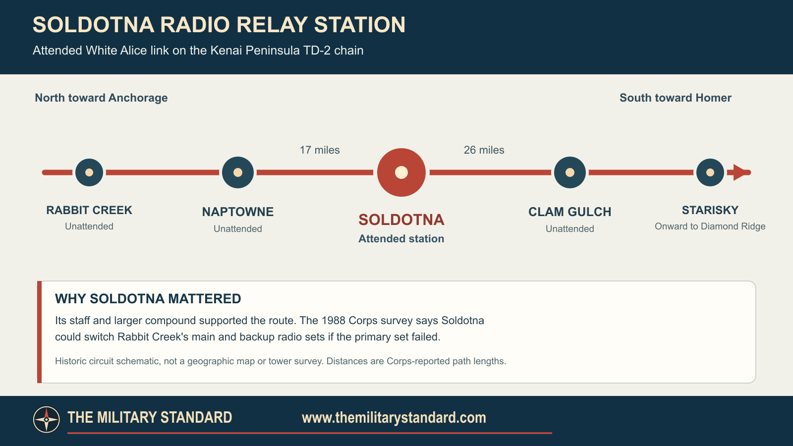
The verified microwave neighbors were Naptowne, about 17 miles north, and Clam Gulch, about 26 miles south. The chain continued north through Rabbit Creek toward Anchorage and south through Starisky Creek and Diamond Ridge. The 1983 Air Force sale study explicitly identifies Soldotna as the attended relay between Naptowne and Clam Gulch and Starisky Creek as the following link toward Diamond Ridge. Another study passage uses "Kenai R1N" and "Kenai R1S" for the adjacent directions; that shorthand does not establish two additional installations. A separate Corps paragraph about Clam Gulch compresses the southward chain and can be read as a direct Diamond Ridge connection. The Air Force's station-by-station route description and the existence of Starisky Creek support showing the intervening link, while acknowledging that network descriptions varied by date and level of detail.
Opening Date And Historical Site
The 1988 Corps inventory dates Soldotna's opening to 1957. The 1994 Corps management plan calls its White Alice facility established in 1958. Neither gives a day or month. The original microwave route may have operated before an expansion was complete, but no construction or acceptance record reviewed here proves that explanation.
The original property described in 1988 had a 4,550-square-foot equipment building, a 4,580-square-foot dormitory intended for twelve people, a 1,560-square-foot garage and maintenance shop, a 206-square-foot fire-pump and water-control building, and a 240-barrel petroleum, oil, and lubricant tank. These are building sizes and tank capacity, not property acreage. The 1994 plan also identifies a communications building, dormitory, tower, and two tropo antennas. Because it was an attended site, the dormitory and shop were integral to sustained operation; the older Army communications use may have influenced the facility's nonstandard layout. The specific builder, every internal room assignment, and an as-built plan of the entire compound were not located.
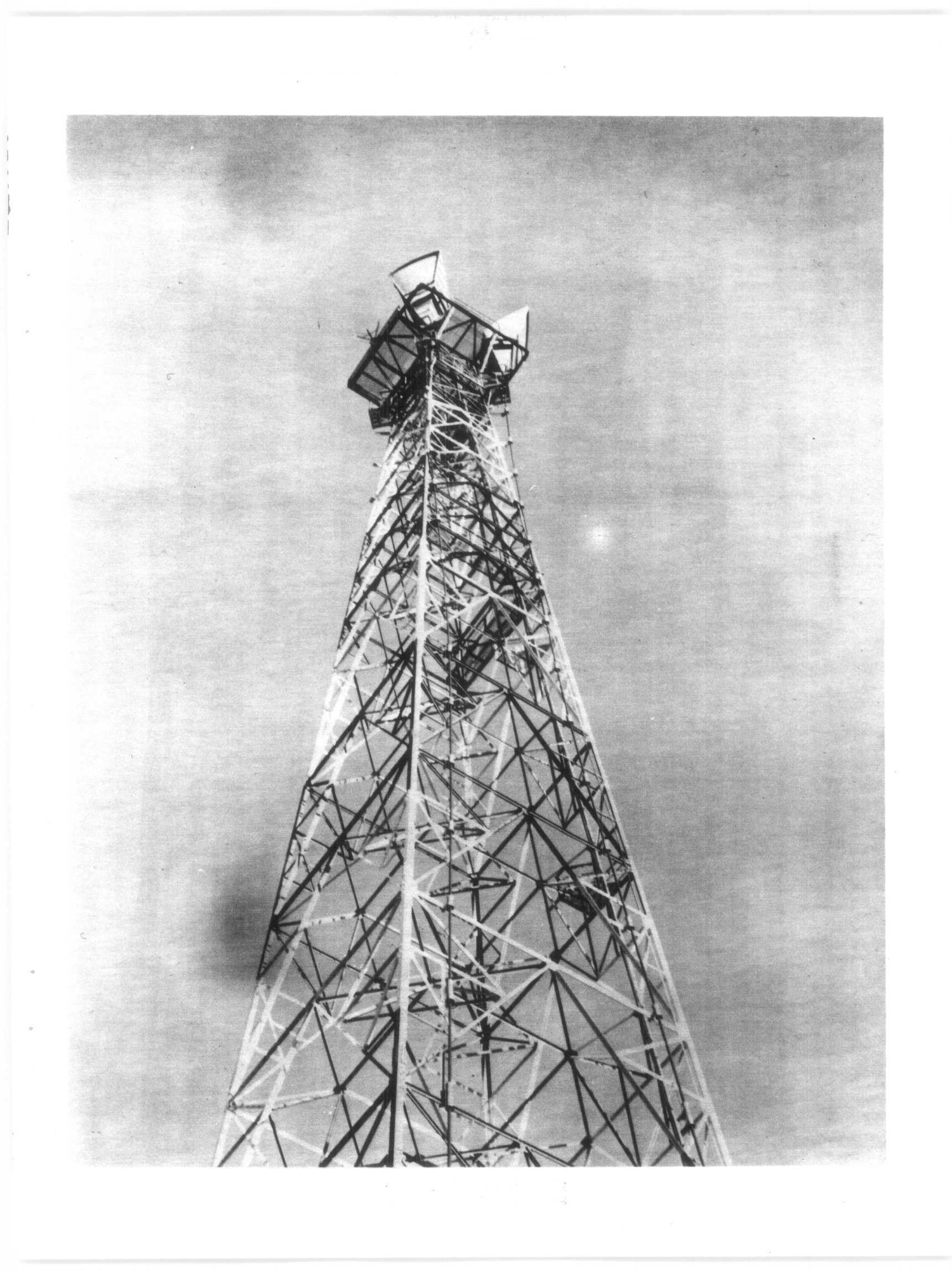
The actual Soldotna TD-2 tower appears as photograph 12 in the 1988 Corps inventory. Its caption index credits the Alaskan Air Command History Office and dates the photographs in the report collectively to 1957-1962. The image is a genuine station view, not a rendering or a photograph of Naptowne. Its upward view shows a substantial lattice structure and antenna framework, but it does not establish a precise tower height, every antenna's function, or the full footprint. The historical photo and the 1994 inventory's two tropo antennas are complementary evidence from different dates.
Equipment, Traffic, And Staffing
The microwave chain used TD-2 equipment, directional antennas, and line-of-sight relays. Soldotna received traffic from one neighbor, processed and retransmitted it toward the other, and could serve local communications demands. The 1983 study's site roster calls it "attended," unlike Naptowne and Clam Gulch. The twelve-person dormitory demonstrates designed accommodation, not an independently verified twelve-person strength on every date. No complete Soldotna duty roster, unit assignment history, circuit diagram, equipment serial list, or continuous staffing schedule was located.
The Corps' unusually detailed walk-through of Rabbit Creek, another Kenai TD-2 relay, reveals a specific role for Soldotna in network operations. Rabbit Creek's main and duplicate "protect" transmitter/receiver complexes could be switched from Soldotna White Alice or the Anchorage toll center if a main set had trouble. This demonstrates that Soldotna was more than a passive intermediate tower: it was a possible remote-control point for protective switching elsewhere on the route. The same paragraph says Naptowne lacked that particular switching capability.
Military And Civilian Traffic
The route was built for air-defense-era connectivity but served a wider Alaska communications market. A concrete example appears in the 1983 Air Force history: on October 3, 1975 the Alaska Public Utilities Commission held a long hearing in Soldotna after Kenai Peninsula customers complained about inadequate long-distance service over the Diamond Ridge-to-Anchorage TD-2 route. The Air Force account identifies two problems: too few long-distance trunks caused frequent all-trunks-busy signals, and RCA's operator-number-identification process added waits averaging about four minutes after a trunk became available. Governor Jay Hammond supported allowing RCA Alascom to add circuits over the existing system. On November 11, the Air Force told him that limited overbuild had been authorized.
The history also shows why a fixed station's mission changed as demand grew. System "overbuilds" could add communications capability without creating a new installation. An Air Force list of six combined troposcatter/TD-2 sites included Soldotna. Nevertheless, the study does not supply a safe frequency, channel count, antenna diameter, or exact modernization date for the Soldotna-specific equipment.
Lease, Sale, And Alascom Continuity
The Air Force negotiated RCA Alascom's lease and eventual sale of White Alice over several years. The 1983 study places a system lease in 1976 and records the system sales contract in August 1983, with final delivery of deeds and bills of sale in October 1983. Soldotna appears among the sites considered for purchase and among microwave facilities from which deactivated equipment was to be removed. These system records establish a transaction framework, not a verified date on an individual Soldotna deed. The station-specific 1988 Corps inventory says Alascom acquired Soldotna in 1983. It also calls the site an active TD-2 microwave station still serving its original purpose, although somewhat remodeled and retaining much original equipment.
The 1994 Corps plan describes continued Alascom communications use, including modern microwave work and a satellite dish. This is evidence of adaptive operation, not proof that every military-era circuit continued or that all historic antennas survived. A 2010 FCC notice lists an Alascom WOE33 radio point nearby; a 2025 FCC public notice records a WOE33 application at another nearby coordinate. A public-notice application is not itself a grant, and a licensed point cannot establish the condition of a 1957 TD-2 set. The latest site-specific historical-plant observation in the reviewed Corps sources remains 1994. The 2025 environmental report independently refers to the equipment building, dormitory, and maintenance area, but it was written for cleanup, not architectural survey.
Historic Preservation And Surviving Fabric
The 1994 cultural-resources plan assigns the Soldotna facility Alaska Heritage Resources Survey identifier KEN-225. It discusses the White Alice system's National Register recognition and recommends evaluation of the individual Soldotna site. That recommendation does not prove Soldotna individually was listed or remains eligible today. The plan observed modifications related to Alascom reuse. The 1988 inventory had already noted remodeling while describing retention of much original equipment.
The 2025 investigation's references to buildings and old fuel-line routes make clear that at least the equipment-building and dormitory locations remained materially relevant decades after military control. However, the environmental report does not distinguish which building fabric is original, what has been replaced, or whether the historic tower and two tropo antennas stand.
Fuel System And Contamination History
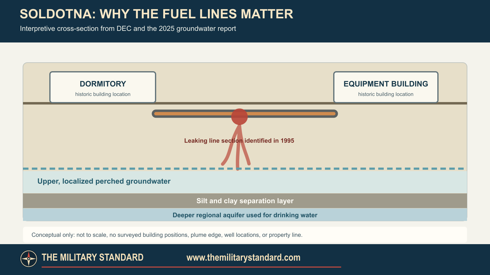
The unusually well-documented fuel system is central to this site's later history. The 2025 groundwater report says a 10,000-gallon aboveground diesel tank installed in the mid-1960s was connected by buried lines to smaller tanks serving the dormitory, equipment building, and automobile maintenance shop. Investigators later found the line section between the dormitory and equipment building had been placed in a corrugated metal culvert to protect it from vehicle loading. Water collected in the culvert, corroded the fuel line, and caused leakage. This was not simply a spill from the original 240-barrel tank described by the 1988 historic inventory; the sources describe different fuel-system components and dates. The relationship between those tanks is not fully resolved.
In 1990, two regulated and one unregulated underground heating-oil tanks were removed. DEC records contaminated soil near the auto shop, with further excavation addressing that area. A 1995 investigation identified leaking lines and petroleum contamination extending to groundwater near the dormitory. Monitoring wells installed between 1995 and 2000, then more in 2006, helped delineate a diesel-range-organics plume around the equipment-building source area. The 2025 report describes contamination down to approximately thirty feet in that area. DEC describes a roughly 200-by-100-foot plume in its summary; those are investigation-era contamination dimensions, not an installation boundary.
In September 2007 contractors excavated contaminated soil along old fuel-line alignments to approximately ten feet and removed the redundant lines. The later report gives 833.8 tons of diesel-impacted soil sent to Anchorage for thermal treatment. Excavation could not safely continue beneath building foundations or near live utility lines, leaving deeper or sidewall contamination. A seasonal soil-vapor-extraction and bioventing system was installed in late 2007 or early 2008 and operated through 2021 according to DEC; one section of the contractor's 2025 report says it has not operated since 2021, another says since 2022. The exact last operating season is therefore best stated as by 2021-2022, not a precise shutdown day. A 2010 in-situ chemical-oxidation pilot did not demonstrate a practical whole-source treatment. Absorbent socks recovered light non-aqueous-phase liquid from one well, but a later check found that some late-period "recovery" weight could have been water rather than petroleum.
The shallow affected groundwater is a perched system above a lower-permeability silt and clay layer, distinct from the deeper regional aquifer used for drinking water. Changing water levels and the shape of the underlying silt have altered apparent flow paths through time. This makes any single plume arrow or property-polygon illustration potentially misleading. A 2022 receptor survey identified two residences about 500 feet downgradient, believed to use deeper wells; the Kenai River lies about half a mile west. These distances and well-screen assumptions do not establish a zero-risk finding for all neighboring properties. The 2025 on-site domestic-well sample had no target analytes detected, a result for that sample and date only.
April 2025 Sampling And Case Status
On April 11, 2025, the contractor sampled monitoring wells MW-6 and MW-11 and the on-site domestic well. The full report gives diesel-range organics of 1.44 mg/L at MW-6, below the 1.5 mg/L DEC criterion, and 19.2 mg/L at MW-11, above it. Naphthalene was 14 and 7.94 micrograms/L respectively, both above the 1.7 microgram/L criterion. No target compounds were detected in the domestic-well sample. No measurable floating product was found, although a slight sheen was noted in MW-11 purge water. The DEC web chronology differs slightly on the MW-6 diesel result, giving 1.46 mg/L, and appears to mislabel the MW-11 diesel result's unit in one action note; the full laboratory-backed report supports 19.2 mg/L.
The contractor recommended decommissioning the remaining monitoring wells and preparing an environmental covenant. DEC's July 2025 action records approval of a report that all on-site monitoring wells had been removed. DEC also recorded a request for cleanup-complete closure with institutional controls, but its public site page still labeled the case "Active" at this audit. A request is not a signed closure determination; an environmental covenant proposal is not proof a covenant is recorded.
Chronology
- Before 1957 The 1994 Corps plan identifies an earlier Army communications station at the Soldotna parcel; its initial date is not established here.
- 1957 The 1988 Corps inventory says the Soldotna microwave station opened.
- 1958 The 1994 Corps plan dates establishment of the Soldotna White Alice facility to this year; the reason for the difference from 1957 is unproven.
- 1957-1962 Alaskan Air Command historical photograph 12 records the actual Soldotna TD-2 tower during the photo set's date range.
- Mid-1960s A 10,000-gallon diesel tank later documented in the environmental record is installed.
- 1975-10-03 A Soldotna public-utilities hearing examines inadequate Kenai Peninsula long-distance service on the TD-2 route.
- 1975-11-11 The Air Force reports authorization of a limited TD-2 circuit overbuild on the Kenai Peninsula.
- 1976 A system-level RCA Alascom lease is documented; this is not a site-specific deed date.
- 1983 The Corps says Alascom acquired the Soldotna station during the White Alice sale.
- 1988 The Corps calls Soldotna an active TD-2 station, describes its original buildings, and reproduces the actual historical tower photo.
- 1990 Two regulated and one unregulated underground heating-oil tanks are removed.
- 1994 The Corps records continued Alascom microwave and satellite-dish use, two troposcatter antennas, and AHRS KEN-225.
- 1995 Investigators identify leaking buried fuel lines and contamination extending toward groundwater.
- 2007 Contractors remove old fuel lines and about 833.8 tons of contaminated soil; deeper contamination remains where excavation threatens structures and live utilities.
- 2007-2008 Seasonal soil-vapor-extraction and bioventing treatment is installed.
- 2010 An in-situ chemical-oxidation pilot is tested; an FCC notice lists the nearby WOE33 Alascom licensed radio point.
- 2021-2022 Seasonal extraction ceases by this interval; the contractor's 2025 report uses both years in different sections.
- 2024 DEC reviews new soil results and approves removal of several monitoring wells.
- 2025-04-11 Final reported groundwater sampling finds exceedances in source-area wells but no target analytes in the on-site domestic-well sample.
- 2025-07-16 DEC approves a report that remaining on-site monitoring wells were decommissioned; requested closure with controls is not a granted closure.
- 2026-10 DEC's public contamination case remains labeled Active; current communications operation and original tower survival are not independently verified.
Information sources (7)
- PDFThe White Alice Communications System: A Historic Overview and Inventory, U.S. Army Corps of Engineers, Alaska District, April 1988
Source for: original-network roster, 1957 opening, Naptowne and Clam Gulch distances, building sizes and tank capacity, 1983 Alascom acquisition, 1988 condition, Rabbit Creek switching detail, and indexed actual Soldotna tower photograph.
- PDFA Special Study of the Sale of the White Alice Communications System, 1931st Communications Wing and Office of Air Force History, October 1983
Source for: attended-station identity, immediate microwave neighbors, Kenai alternate name, 1975 public hearing and overbuild, and lease-and-sale context.
- PDFThe Cold War in Alaska: A Management Plan for Cultural Resources, U.S. Army Corps of Engineers, Alaska District, August 1994
Source for: former Army communications-station identity, 1958 alternative date, two troposcatter antennas, Alascom-era microwave and satellite reuse, and AHRS KEN-225.
- WEBAT&T Alascom Soldotna Microwave, Alaska Department of Environmental Conservation, hazard ID 1004
Source for: site address and NAD83 mapped point, fuel-line and cleanup chronology, 2025 well-decommissioning action, and currently Active case status.
- PDF2025 Groundwater Monitoring Report - Soldotna Repeater Site, ALTA Geosciences for Avangrid Renewables Holdings, May 12, 2025
Source for: fuel-system mechanism, treatment limits, shallow groundwater context, April 11 sampling results, and proposed environmental covenant. This consultant report is used as evidence, not as image-reuse permission.
- PDFFCC Public Notice DOC-301909A1, Federal Communications Commission, September 2010
Source for: later Alascom WOE33 licensed radio point, not a historic station survey or proof of current TD-2 operation.
- PDFFCC Public Notice DOC-413458A1, Federal Communications Commission, August 2025
Source for: later WOE33 application at a nearby radio point; application notice alone does not prove grant or present operation.