
Cape Romanzof Air Force Station / Cape Romanzof Long Range Radar Site, Alaska
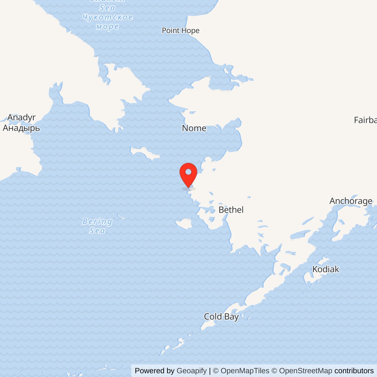
Longitude: -165.96194
Site Number: F-06; A-10
Airport ICAO ID: PACZ (support airfield; not radar identifier)
Current Role: Active Alaska Radar System long-range radar, contractor support, restricted official-business airfield access, and continuing environmental monitoring/investigation.
- Historic unit
- 795th Aircraft Control and Warning Squadron
- Radar service began
- April 1953
- Staffed station phase ended
- November 1983; the radar mission continued
- Later radar
- AN/FPS-117 conversion documented across 1984-1985
- Approximate upper-radar point
- 61.78972 N, 165.96194 W from a specialist station inventory; not a surveyed antenna or property centroid
- Reported installation area
- 4,900 acres in the Alaska DEC summary; not a surveyed boundary
Identity and Geography
Cape Romanzof Air Force Station was a staffed aircraft control and warning station on Alaska's Bering Sea coast. The active Cape Romanzof Long Range Radar Site is its successor phase at the same larger installation, not a second unrelated radar base. The historic radar identifier was F-06 and the later long-range-radar identifier is A-10. From Towak Mountain the station watched the western approaches to Alaska, while a lower support camp, separate airstrip, access road, former tram route, beach landing area, and communications works stretched the operation across difficult terrain. The Air Force's 1950s choice of a high, exposed radar position created the line of sight needed for warning but made transport, power, fuel, communications, and weather protection central parts of the mission. [1][2][3]
The Alaska Department of Environmental Conservation describes a 4,900-acre LRRS within the Yukon Delta National Wildlife Refuge. This is a reported installation area, not a parcel survey or a statement that every acre is an Air Force-owned fee parcel. A published specialist radar-site point near 61.78972 N, 165.96194 W represents the upper radar vicinity; it is approximate, not a surveyed antenna center. DEC's 61.735820 N, 165.938290 W is its installation-level environmental record marker and is several miles from that upper-camp point. The FAA-derived airport reference point, 61.7810144 N, 166.0395754 W, represents the support airfield, not the radar. [3][4] [5]
Site Selection and Construction
Alaskan Air Command and the Army Corps of Engineers surveyed the location in 1949 as they designed a permanent warning chain against aircraft approaching from the west. The elevated site offered an unobstructed horizon, but its steep slopes and short supply season made construction unusually demanding. Gaasland & Company received the contract in June 1950, and the official Alaska historic study gives $4,322,751 as the initial construction cost. Construction was substantially finished in 1952; the radar station became operational in April 1953, a distinction between completing the physical plant and beginning its warning mission. Cape Romanzof belonged to the original group of Alaska AC&W stations, although official summaries variously count ten original operating sites or twelve early sites depending on the program boundary used. [1][2][6]
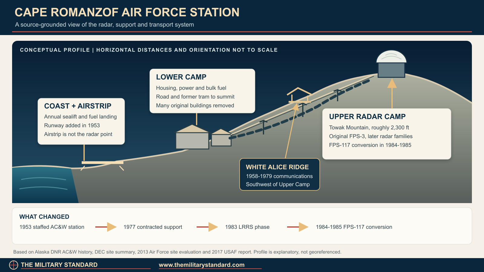
The builders organized the installation as two camps. The upper camp held the radar, operations functions, and some operator quarters near the 2,300- to 2,350-foot summit of Towak Mountain. The lower camp occupied a sheltered bowl and held housing, the power plant, bulk fuel storage, and much of the daily support infrastructure. Before the tramway connected the camps in October 1953, people climbed to the radar carrying about a week's supplies. A later access road gave vehicles an alternative route, but neither route erased the severe effects of fog, wind, snow, and icing on upper-camp work. Official descriptions use somewhat different elevations for the upper and lower facilities; the figures here identify broad terrain levels rather than surveyed finished-floor heights. [1][2] [7]
Sea, Air and Overland Logistics
Bulk supplies arrived by the annual Mona Lisa sealift, later called Cool Barge. Landing craft moved cargo across the beach and fuel entered storage through a pipeline, then personnel had to move materials onward to the dispersed camps. A runway was added in 1953 for passengers, mail, emergency items, and smaller cargo, so the airfield complemented rather than replaced the sealift. The state historic study places the lower camp well above the shore and the airstrip below it, illustrating why a functioning road, vehicles, tanks, and utility lines were operational necessities instead of minor conveniences. An aircraft or barge delay could affect people as well as the ability to repair a radar or generator. [1][7]
The current Cape Romanzof LRRS Airport is an Air Force-associated, private-use installation airfield, not a public gateway to an abandoned historic site. FAA-derived data list a 3,955-by-120-foot gravel Runway 02/20 and official-business-only access. A 2017 Air Force account describes the difficult uphill landing and a narrow, winding drive from the lower camp to the radome. That account gives a useful modern check on the original engineering problem: even after the military garrison was replaced by a small contractor team, personnel and replacement parts still had to reach a mountain radar through weather-limited air and ground connections. [4][8]
The 795th and the Staffed Warning Mission
Detachment F-6 of the 531st Aircraft Control and Warning Group initially occupied the installation. The 795th Aircraft Control and Warning Squadron activated on 8 December 1952, before the April 1953 operational opening, and became the station's principal military unit. The squadron operated and maintained the radar, followed aircraft plots, and passed track information to the regional air-defense command chain. Its identity endured through several changes in higher headquarters. A location listing for the 795th and its activation date is preserved in an Air Force Historical Research Agency-derived lineage compilation, while the Alaska historic study supplies the detachment and local station context. The dates for assigning individual support specialists or small detachments are not fully reconstructed here. [1][2]
Cape Romanzof was an early-warning sensor rather than an interceptor airfield or a direction center. Its operators supplied detections that regional controllers could combine with reports from other sites and use to direct aircraft. That distinction explains both the site's mountain location and the importance of communication reliability. The radar crew's work could not produce a useful regional warning if the link away from Cape Romanzof failed. The station's isolation also meant that routine domestic functions, from meals and medical contingencies to fuel delivery and heating, had to be planned around limited access. The available sources do not support a precise, constant military headcount for all decades of staffed operation, and contractor changes later altered the staffing model substantially. [1][2][6]
Radar and Data-System Evolution
The original search radar was an AN/FPS-3. The documented family of later search configurations includes AN/FPS-20A, AN/FPS-87A, and AN/FPS-93A before AN/FPS-117. The Alaska state historic study compresses the middle stages by describing the FPS-3's replacement with FPS-93A, while the AFHRA-derived 795th equipment line preserves FPS-20A and FPS-87A as intervening configurations. Those are not grounds for claiming all the models were on separate towers at once, and the exact installation and removal dates of each interim configuration are not established by the reviewed sources. A rigid radome was installed in October 1959, protecting the exposed search equipment from an environment that could rapidly disable an open antenna. [1][2][9]
The AN/FYQ-9 semiautomatic data-processing and display system was installed in 1965. It improved the passage of tracks toward the control system, reducing dependence on purely manual plotting and reporting while still requiring local personnel. Cape Romanzof therefore evolved before the 1980s transition: the radar hardware changed, the information path became more automated, and a contractor support model gradually reduced the military complement. AN/FYQ-9 should not be confused with a radar antenna; it was part of the processing and reporting chain. The Alaska historic study explicitly documents its installation at Cape Romanzof but does not supply a day-level acceptance date. [1][2]
White Alice and Communications
Early high-frequency radio was vulnerable to Alaska's difficult propagation and weather. In February 1958 the White Alice Communications System replaced that primary link at Cape Romanzof, connecting the isolated radar with the wider military communications network. The White Alice facility stood on a ridge southwest of Upper Camp, a distinct communications area within the larger installation, rather than another radar search station. A tropospheric-scatter path connected Cape Romanzof with Bethel, which in turn linked other western Alaska sites including Cape Newenham and Aniak. Construction associated with the communications system also brought a roughly two-mile access road between the base and top camps. [1][10][11]
Cape Romanzof's White Alice operation ended in 1979, with the state historic study specifying May and DEC giving the broader 1958-to-1979 interval. An Alascom-owned satellite earth terminal replaced it as part of a wider shift away from the costly White Alice network. This was a communications transition, not closure of the radar. DEC identifies the former White Alice location as environmental site OT006 and records it as cleanup complete; the former communications structures were demolished. That site record is a useful reminder that a former WACS area, the active radar compound, and the installation as a whole can carry different operational and environmental statuses even though they share the Cape Romanzof name. [1][10][12]
Role in the wider military network
Cape Romanzof was one element of a geographically distributed warning screen. King Salmon functioned as a southern Alaska direction-center relationship; Cape Newenham covered a different part of the southwestern coast, and other AC&W stations covered northern and interior approaches. Cape Romanzof supplied early-warning observations, while communications links carried the information onward for regional evaluation and potential interception. Bethel White Alice was especially important to that data path in the 1958-1979 period. These places were related nodes of the Alaska defense system, not annexes of Cape Romanzof. The distances, terrain, and lack of road connections made the network's communications and logistics components as consequential as the radar sets themselves. [1][6][11]
The relationship changed when the Joint Surveillance System made it possible to send radar and beacon information by satellite to the Elmendorf Region Operations Control Center. The 1983 regional-center transition displaced functions that had required more people at remote stations. It did not remove Cape Romanzof from the warning perimeter. Later minimally attended radar technology continued to provide coverage from the cape while a much smaller local team maintained equipment and communications. The modern Air Force account of radome maintenance shows that specialist depot teams still travel to the site and work with resident contractors; remote control never meant that the physical radar could operate without fuel, power, access, and hands-on maintenance. [1][6][8]
Contract Support, Redesignation and Seek Igloo
In 1977 Alaskan Air Command adopted an RCA Services support contract at Cape Romanzof that eliminated 81 military positions and left approximately 14 military personnel, mainly in operations. DEC calls the station minimally attended by that year, but the contemporary staffing figure shows an intermediate contractor-supported stage, not the completed AN/FPS-117 minimally attended radar configuration. When the Elmendorf regional operations center and JSS links became operational in 1983, the Air Force withdrew the remaining squadron personnel and inactivated the 795th. Secondary retellings give 1 November 1983 for inactivation; the official state historic study supports the year but not the exact day in the material inspected. Accordingly, this history treats November 1983 as the staffed-phase end while leaving the precise day qualified. The station then carried the Cape Romanzof LRRS designation without ending the radar mission. [1][2][3][6]
Seek Igloo brought the AN/FPS-117 radar and new composite facilities. The AFHRA-derived 795th compilation says the FPS-117 was installed in summer 1984; the Alaska historic study describes re-equipping the station in August 1985. Those statements may refer to delivery or installation versus operational conversion, but the source excerpts do not explicitly reconcile them. The responsible conclusion is a 1984-to-1985 conversion, not a falsely exact operational day. The double-geodesic-dome composite building was constructed in 1984-1985 for the smaller team and equipment. This architecture was distinctive among Alaska radar stations. [1] [2][6]
Demolition, Surviving Fabric and Historic Value
The new radar and small support team made much of the 1950s station unnecessary. DEC reports that 24 buildings, eight foundations, and antennas were demolished in 1988. The official Alaska historic study and a 2013 Air Force site evaluation nevertheless record surviving components of the older plant, including a radome tower, pump house, airfield, vehicle fueling station, roads, and remnants or listed elements of the aerial tramway, plus a 1964 covered-storage building. The 2013 evaluation also lists later MAR-period utilities and buildings. These dated inventories should not be treated as proof that every listed feature remains intact in 2026; they establish what investigators identified at the time and show why the site is neither an untouched Cold War station nor a completely erased one. [1][3][7]
A 1998 cultural-resource assessment recommended the former AC&W installation as not eligible for the National Register of Historic Places because extensive demolition had compromised the historic complex. That assessment is a finding about the integrity of the older installation, not a claim that Cape Romanzof lacks historical significance or that the active radar should be closed. Photographs in official and archival sources show very different phases: the old upper camp, the later paired domes, and the 2017 active radome. [1][6] [8]
Environmental Investigation and Remedies
Environmental investigation began in 1989 after decades of fuel handling, waste disposal, equipment use, and station demolition. Alaska DEC documents petroleum, PCBs, lead, munitions debris, and impacts to soil, sediment, surface water, and groundwater in different portions of the installation. The 4,900-acre area contains many separately tracked environmental sites; a cleanup-complete determination for one does not close the entire LRRS. Remedies have included excavation, caps and institutional controls, monitoring, and restrictions on disturbing or moving residual contaminated soil. The Air Force and DEC also investigated whether contamination could affect wildlife and subsistence resources relied upon by nearby communities. The history of the installation therefore includes continuing responsibility to the surrounding refuge and communities, not only the radar's military mission. [3][12][13]
DEC's March 2026 summary identifies ongoing investigations at ST009, SS017, and LF003. Monitoring includes groundwater at SS015 and ST009, inspections at SS016 and SS017, and sediment and surface-water sampling at LF003; other areas receive five-year-cycle inspections. A 2020 preliminary assessment and site investigation found PFAS above state cleanup levels in soil, groundwater, or surface water at three areas: Fire Training Area No. 1, Landfill No. 4, and Biocell 3. DEC says additional remedial investigation is planned. Those findings support further delineation, not a blanket claim that nearby village drinking-water supplies are contaminated or that all exposures are resolved. The current DEC database should be checked before any site-access or land-disturbance decision. [3][14]
Current Status and Photographic Record
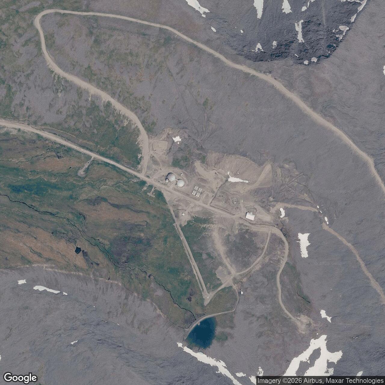
Cape Romanzof remained an active Alaska Radar System site in the latest state summary reviewed here. A 2017 official Air Force maintenance report documents contractor technicians, Air Force depot specialists, and a functioning radome on Towak Mountain. It depicts why the active installation still requires access by aircraft and a road from the lower camp. The Air Force's official photographs from that visit provide credible visual evidence of the later radome, residential dome interior, runway approach, and severe weather. DEC's site page also displays a 2015 lower-camp photograph and a 2023 installation figure with the airstrip and the two camps; those are useful dated references for the physical layout. This history does not infer the exact 2026 staffing level from the 2017 visit or claim that the photographed 2017 equipment was the 1953 radar. [3][8]
The continuing radar mission and the simultaneous cleanup program are best understood as one evolving installation. Cape Romanzof began as a large, difficult-to-supply human outpost, moved through improved radar and communications, shed most military and historic buildings, and now depends on a smaller maintenance system supporting a technologically different sensor. Its archival record is unusually clear about the upper/lower camp arrangement and the period of major demolition, but less complete on exact interim radar swap dates, legal parcel boundaries, and the precise service dates of every remaining structure. Those limits are part of the documented history, not gaps to fill by guesswork. [1][3][8]
View the official 2017 Air Force photographs of the active Cape Romanzof radome, support dome and airfield. These show the later LRRS, not the original FPS-3 antenna.
Chronology
- 1949 Alaskan Air Command and the Army Corps of Engineers survey the Cape Romanzof location for early warning.
- 1950-06 Gaasland & Company receives the initial construction contract.
- 1952 The main installation construction is substantially finished.
- 1952-12-08 The 795th Aircraft Control and Warning Squadron activates for Cape Romanzof.
- 1953-04 Cape Romanzof enters operational aircraft-warning service with AN/FPS-3 lineage.
- 1953 A runway is added to supplement annual sea supply.
- 1953-10 A tramway connects lower support facilities to the upper radar camp.
- 1958-02 White Alice replaces the station's primary high-frequency communications link.
- 1959-10 A rigid radar radome is installed, according to the 795th equipment chronology.
- 1960s The initial FPS-3 search set is succeeded through FPS-20A/FPS-87A and FPS-93A family configurations; exact interim dates remain unresolved.
- 1965 The AN/FYQ-9 data-processing and display system is installed.
- Early 1970s The aerial tram is decommissioned according to the Alaska historic study.
- 1977 RCA Services support contracting removes 81 military positions while a small operations complement remains.
- 1979-05 Cape Romanzof White Alice is deactivated and replaced by commercial satellite communications.
- 1983 JSS links and the Elmendorf regional operations center permit remote handling of radar information.
- 1983-11 The 795th ends its staffed-site mission and the installation enters its LRRS phase; secondary summaries give November 1.
- 1984 summer An AFHRA-derived equipment summary dates FPS-117 installation to this period.
- 1984-1985 The double-geodesic-dome composite facility is constructed for the minimally attended radar phase.
- 1985-08 The Alaska historic study describes Cape Romanzof's Seek Igloo re-equipping by this date.
- 1988 The Air Force removes most older AC&W facilities, including 24 buildings and eight foundations as summarized by DEC.
- 1989 Environmental investigation begins at the LRRS.
- 1998 A cultural-resource assessment recommends the former AC&W complex as not eligible for National Register listing because of demolition.
- 2013 A site evaluation inventories surviving older features and MAR-period facilities; it does not certify their 2026 condition.
- 2017-09 Air Force depot specialists photograph and maintain the active Towak Mountain radome and document the difficult air and road access.
- 2020 A PFAS preliminary assessment and site investigation identifies three areas for further work.
- 2023 An Air Force installation figure used by DEC maps the airstrip, lower camp, upper camp, and environmental sites.
- 2026-03 DEC updates its summary of active cleanup, monitoring, and PFAS investigation.
Historical photographs and maps
The Alaska Department of Natural Resources historic study reproduces a Cape Romanzof upper-camp photograph from 11th Air Force archives. The Alaska DEC Cape Romanzof page provides a 2023 Air Force site figure that distinguishes landing strip, lower camp, and upper camp, and a 2015 lower-camp photograph. A 2017 U.S. Air Force article includes directly captioned photographs of the later radome, residential dome, and runway. Those dated, identified images are preferable to an invented picture of the early radar. The accompanying source-grounded schematic in this history is explicitly conceptual: it shows functional relationships and approximate elevation order, not a surveyed map, building footprint, antenna outline, or scaled route. [1][3][8]
Information sources (14)
- PDF[1] Alaska Department of Natural Resources, History of the Aircraft Control and Warning System in Alaska
SOURCE FOR: 1949 selection, Gaasland contract, 1952-1953 construction and operation, two-camp/tram layout, 795th, equipment, White Alice, RCA contract, Seek Igloo, surviving features, and historic assessment.
- PDF[2] Air Force Historical Research Agency-derived, 795 Aircraft Control and Warning Squadron
SOURCE FOR: 8 December 1952 activation, Cape Romanzof assignment, FPS-3/FPS-20A/FPS-87A/FPS-93A/FPS-117 family listing, April 1953 operation, 1959 rigid radome, and summer 1984 FPS-117 installation statement.
- WEB[3] Alaska Department of Environmental Conservation, Cape Romanzof Long Range Radar Site
SOURCE FOR: active LRRS, 4,900-acre reported area, lower and upper camps, 1988 demolition, contaminants, monitoring, PFAS investigation, 2023 site figure, and dated lower-camp photograph.
- WEB[4] Federal Aviation Administration data as published by AirNav, Cape Romanzof LRRS Airport PACZ
SOURCE FOR: airfield reference point, private official-business-only status, 3,955-by-120-foot gravel Runway 02/20, and airfield/radar location distinction.
- WEB[5] FortWiki, Alaska Manual System Radar Sites location inventory
SOURCE FOR: approximate published F-06 upper-radar point, treated as a specialist inventory coordinate rather than a surveyed antenna or land-boundary control.
- PDF[6] U.S. Army Corps of Engineers, The Cold War in Alaska: A Management Plan for Cultural Resources
SOURCE FOR: original AC&W setting, 1977 contractor staffing change, 1983 regional-control transition, 1979 satellite replacement, and historical relationship between radar, camp, and airstrip.
- PDF[7] U.S. Air Force, Cape Romanzof LRRS CSE Phase I/II Final Report, October 2013
SOURCE FOR: October 1953 tram, 1953 runway, upper/lower camp and supply methods, and dated inventory of surviving pre-MAR and MAR-period structures.
- WEB[8] U.S. Air Force, Depot field team braves Alaska weather to perform radome maintenance, 11 October 2017
SOURCE FOR: active radar-site support, ARCTEC and Air Force depot field-team functions, aircraft/runway and mountain-road access, and dated official photographs of the later radome and support facilities.
- WEB[9] Radomes.org, Cape Romanzof AFS station inventory
SOURCE FOR: specialist corroboration of F-06/A-10 code, equipment sequence, October 1959 radome, and approximate upper-station point; exact antenna survey not claimed.
- WEB[10] Alaska Department of Environmental Conservation, Cape Romanzof LRRS OT006 White Alice Site
SOURCE FOR: separate White Alice area southwest of Upper Camp, 1958-1979 operation, demolition, and site-specific cleanup status.
- WEB[11] Joint Base Elmendorf-Richardson, Cold War era White Alice antenna felled for a clean and safe dismantling
SOURCE FOR: Bethel relay connections with Aniak, Cape Romanzof, and Cape Newenham, and the 1979 White Alice network transition.
- WEB[12] Alaska Department of Environmental Conservation, Cape Romanzof LRRS environmental site reports
SOURCE FOR: separately tracked White Alice, fuel, landfill, road-oiling, and other environmental components rather than one all-site cleanup status.
- WEB[13] Alaska Department of Environmental Conservation, Cape Romanzof LRRS SS008 and OT006 decision records
SOURCE FOR: cleanup decision examples and the difference between site-specific remediation and the larger operating installation.
- WEB[14] Alaska Department of Environmental Conservation, Cape Romanzof PFAS investigation
SOURCE FOR: site-inspection and follow-up context for PFAS at the LRRS, read together with the March 2026 DEC summary.