
Laredo Gap Filler Annex, Webb Texas
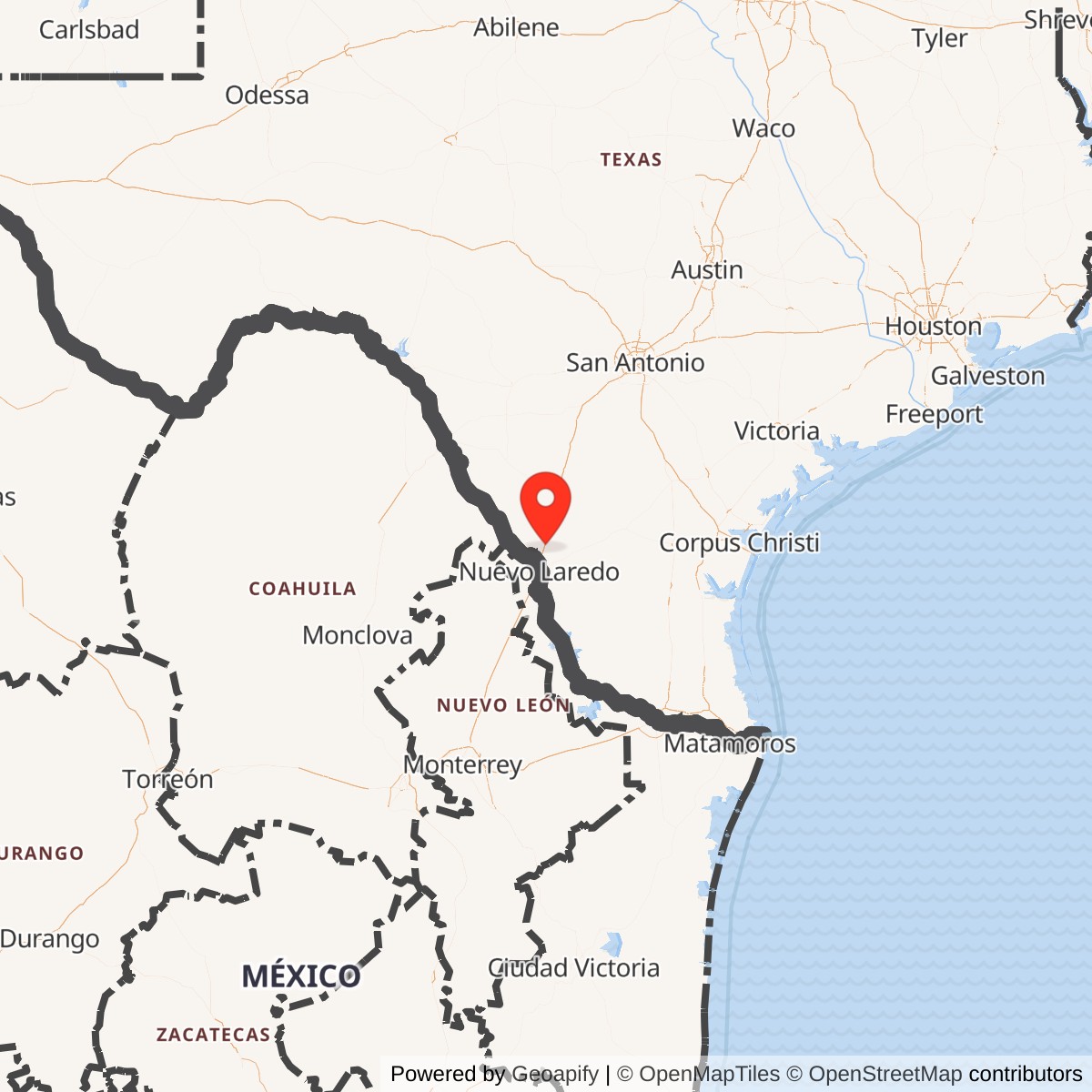
Longitude: -99.435
Site Number: TM-189B; TM-188C; PIN 5677; AN/FPS-18
Location: Webb County, north-northeast of Laredo, Texas
Site designations: TM-189B / TM-188C
Mission: Unattended short-range aircraft search radar supporting Zapata and later Eagle Pass AFS
Documented service: October 1959 to 1963; exact final radar day unverified
Overview
The Laredo Gap Filler Annex was a small, unattended Air Defense Command aircraft-surveillance installation in Webb County, Texas. It operated an AN/FPS-18 short-range search radar to supplement the coverage of larger, staffed radar stations. Air Force tables first identify the annex as TM-189B, in the Zapata radar program, with an October 1959 manual-operating date. Later tables list the same Laredo location as TM-188C under the 733rd Aircraft Control and Warning Squadron at Eagle Pass Air Force Station, with a December 1960 manual-operating entry. The site became excess to ADC requirements in 1963.
This annex must be distinguished from two other Laredo installations. Laredo Air Force Base was the aviation and training base. The separate Laredo Air Force Station, also called the Laredo Tracking Site, operated large radars for experimental missile detection, space surveillance and later missile warning. The gap filler was neither that tracking station nor a radar position within its long-range sensor complex. Its administrative property number was PIN 5677; the tracking station had a different identity, PIN 5346 and Z-230. Keeping these facilities separate is essential to understanding their equipment, dates and later property histories.
Location and Historical Setting
Specialist radar-site records place the annex north-northeast of Laredo, south of the community of Webb and east of present-day Interstate 35. Radomes describes the position approximately as 15 miles north-northeast of Laredo, two miles south of Webb and half a mile east of I-35. Its satellite index qualifies the identification as based on a veteran's recollections. This is a useful regional locator, but not a surveyed military boundary or an independently verified present-day parcel identification.
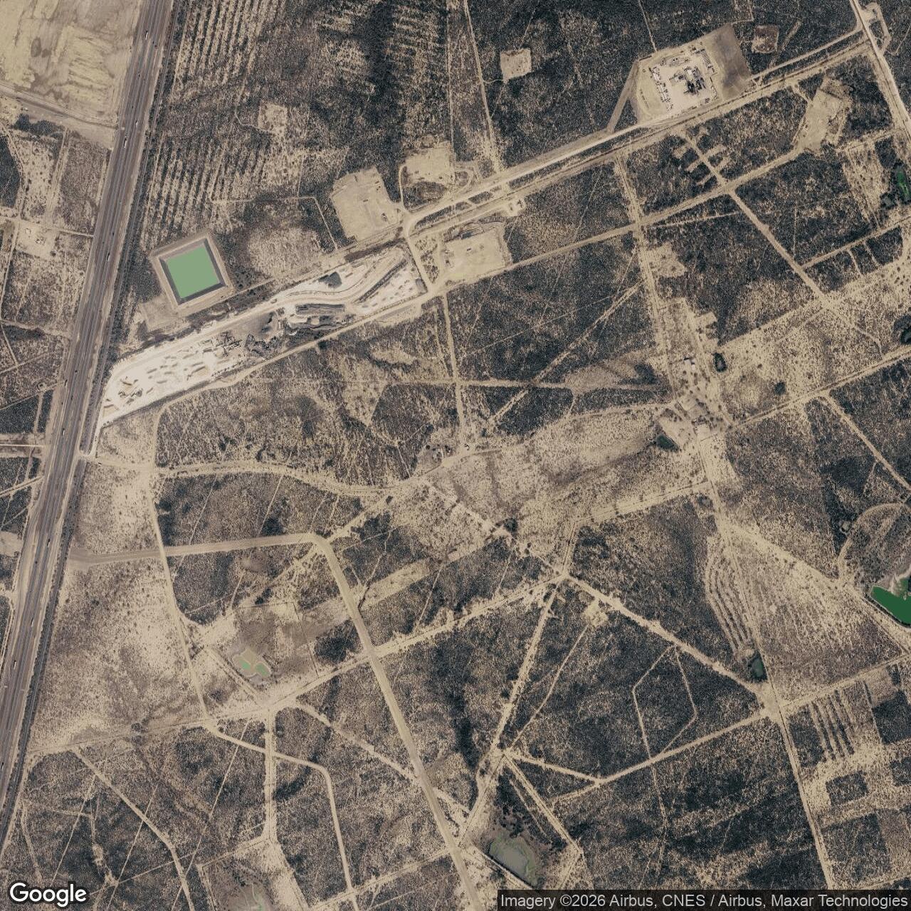
Approximate historical locator: 27.726 north, 99.435 west. This rounded point comes from specialist location tables, not a recovered Air Force survey. It identifies an area for further map comparison and should not be treated as the precise antenna position, property corner, entrance or public-access point. No verified annex-specific acreage or boundary has been recovered.
The annex's purpose reflected a basic limitation of ground-based aircraft radar. A distant aircraft flying low could remain below a main station's radar horizon or be hidden by intervening terrain. A smaller radar closer to that flight path could provide observations that the larger station could not reliably obtain. Laredo belonged to a network of such remote sensors in southern Texas. Its value was supplemental low-altitude aircraft coverage, not the exceptional range, space-object measurement or missile-warning capability associated with the other Laredo radar installation.
Planning and Construction

The earliest recovered contemporary construction evidence is a brief item in The Cotulla Record of March 8, 1957. It reported that the Corps of Engineers had sought construction bids that week for two unmanned gap-filler stations at Carrizo Springs and Laredo, alongside a separate sewage-treatment project at the large Eagle Pass radar station. This establishes that Laredo had reached public procurement by early March 1957. It does not establish a successful award, contractor, construction cost, ground-breaking date or completion date. The contractor mentioned later in that newspaper item concerned a different project, not the radar annexes.
The newspaper also demonstrates that Carrizo Springs and Laredo were conceived as separate unmanned facilities, rather than staffed extensions of a common cantonment. An exact Laredo acquisition instrument, construction contract and acceptance report have not been located. October 1959 is therefore used for the documented radar-operating milestone, not as a substitute date for land purchase or the beginning of construction.
Official Identity and Operating Chronology
The Air Defense Command historical compilation reproduces a 1959 gap-filler roster that records Laredo as TM-189B with an AN/FPS-18 and an October 1959 date in the manual-operation column. The June 30, 1960 roster repeats that equipment and date. The SAGE-operation column is blank. These tables provide considerably firmer evidence than modern descriptions which assign the annex a generic gap-filler radar model or treat every late-1950s radar as a directly connected SAGE sensor.
The TM-189 designation places the first documented identity in the Zapata Air Force Station program. Zapata's parent unit was the 742nd Aircraft Control and Warning Squadron. The official organizational handbook records that squadron moving to Zapata on July 1, 1957; the ADC facilities table records the main station beginning radar operation in May 1959. The same table distinguishes the cessation of Zapata radar operations on August 1, 1960 from the squadron's discontinuance on June 1, 1961. Those are parent-station milestones, not automatically Laredo's own shutdown dates.
The later command roster, dated December 31, 1961, lists Laredo as TM-188C, associates it with squadron 733, and records December 1960 in the manual-operation column. The 733rd operated Eagle Pass AFS, TM-188. Taken together with the earlier Laredo entry, this documents continuity of a remote radar under a different parent arrangement. December 1960 is the best recovered month-level milestone for the later operating identity. No annex retie order establishing the exact administrative transfer day has been found, and the later entry is not interpreted as the first construction or first operation of an entirely new Laredo site.
The command's Special Order G-83 of June 28, 1963 removes any remaining doubt about the later administrative relationship. It names Laredo Gap Filler Annex, TM-188C, assigns PIN 5677 and identifies Eagle Pass AFS as its primary installation. Some secondary tables use TM-188B for Laredo. The official later roster and excess order support TM-188C, while the early tables support TM-189B. These are the identifiers retained here.
AN/FPS-18 Radar and Its Contribution
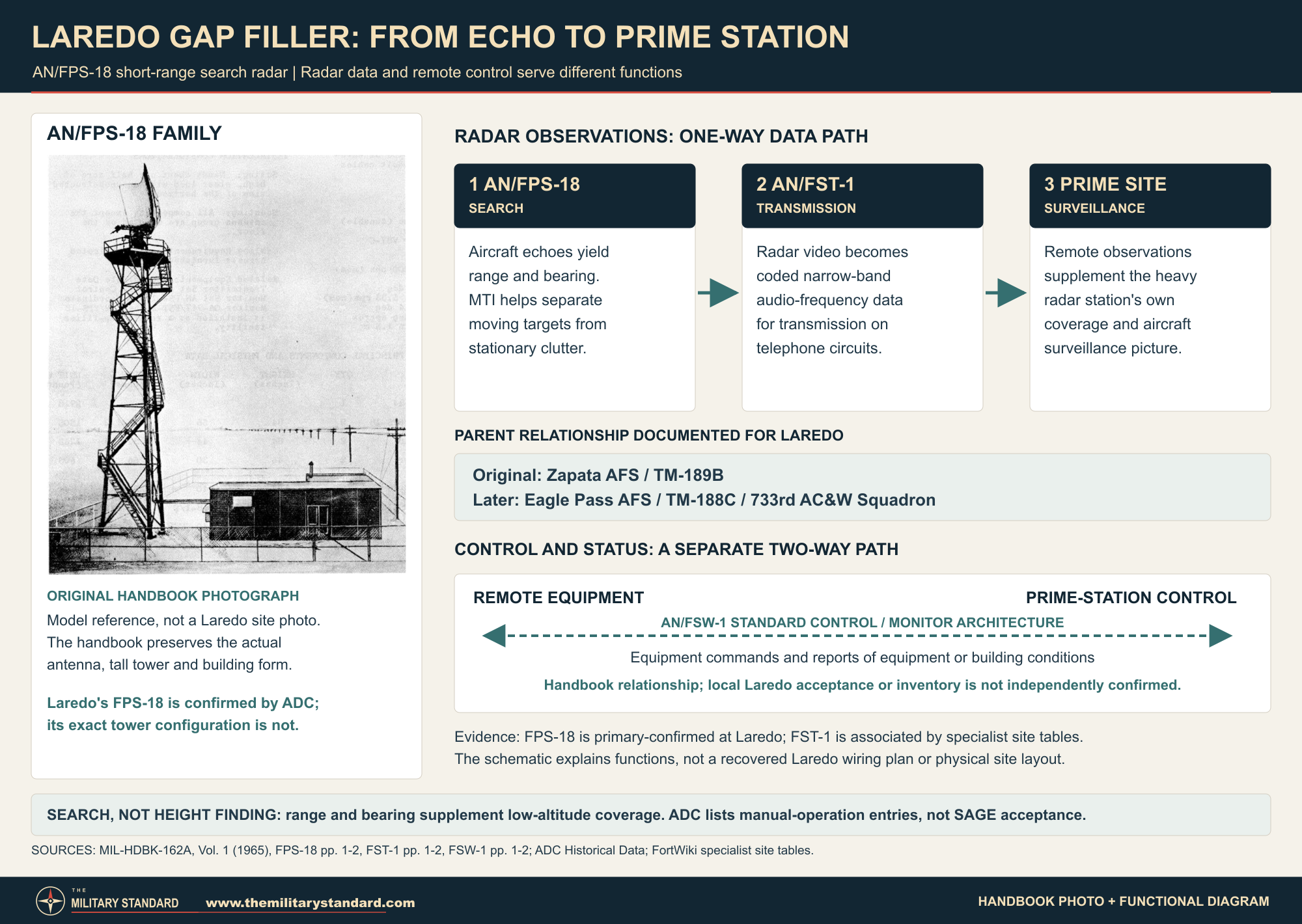
The confirmed Laredo radar was the AN/FPS-18. ADC repeatedly identifies that model in the annex's operational tables. There is no recovered evidence of an earlier local AN/FPS-14, a later AN/FPS-18A installation, or a different replacement radar.
The December 1965 military equipment handbook, MIL-HDBK-162A, describes the FPS-18 family as a Bendix-built, medium-power, short-range search radar with a coherent klystron transmitter and moving-target indication. Moving-target indication helped distinguish moving aircraft returns from stationary background echoes. The set scanned around the horizon, providing aircraft range and bearing. It was not a dedicated height finder, and a search return from this annex alone should not be described as a complete three-dimensional track or an independently determined interception solution.
Published model characteristics include a tunable frequency band of 2,700 to 2,900 MHz, 360-degree horizontal coverage, a nominal antenna rotation rate of 5.33 revolutions per minute and a one-megawatt peak transmitter output. The handbook lists a maximum range of 50 nautical miles, while separately describing line-of-sight detection of an F-86 at up to 35 nautical miles and 17,000 feet. Those are different specifications and test-reference conditions, not interchangeable promises of continuous local coverage. No Laredo flight-check report has been recovered to establish its actual detection envelope.
Two automatically interchangeable transmitter and receiver channels were an important feature of the design. If one channel failed, the other could take over. That redundancy reduced dependence on having an operator continuously present beside the radar. The antenna system also allowed remote selection of vertical or circular polarization. These capabilities explain how this equipment family could serve at unattended outposts. The 1965 handbook was published after Laredo closed, however, so its model description is used to explain documented FPS-18 equipment, not to prove every listed component or later model revision was installed locally.
Data Transmission, Remote Control and Maintenance
Unattended operation depended on communications as well as the radar. The handbook identifies AN/FST-1 Coordinate Data Transmitting equipment and AN/FSW-1 Control Monitor equipment as associated systems for a remote FPS-18 gap filler. Specialist Laredo tables also associate the annex with FST-1. This provides a reasonable explanation of its operational architecture, although a Laredo installation schedule, circuit drawing or detailed communications inventory has not been recovered.
The FST-1 converted wide-band radar video into coded, narrow-band audio-frequency signals suitable for standard telephone circuits. Its destination was an associated heavy radar site, where the remote observations could be used with the main station's surveillance information. The handbook describes data, timing, synchronization and north-reference information, and alternative telephone-pair configurations. The exact configuration used at Laredo is unknown.
The FSW-1 served a different function: control and condition reporting between the prime station and a remote annex. Its handbook entry describes control of equipment functions and monitoring of equipment or building conditions over a standard telephone pair, with equipment at both ends. This helps explain the division of labor between remote machinery and the staffed parent station. Radar data transmission and remote monitoring were related but distinct tasks; the existence of one should not be mistaken for proof of the exact locally installed configuration of the other.
The contemporary construction notice expressly described Laredo as unmanned. That term does not mean the radar required no human attention. Maintenance, fault investigation and repairs remained necessary, but they did not require a resident crew of controllers conducting interceptions at the annex. No local maintenance roster, technician's account, inspection schedule or outage log was found.
Manual Operations and the Parent Network
Both recovered operating milestones for Laredo occur in ADC's manual-operation column, while its SAGE column remains blank. The annex should consequently be described as an automatic remote sensor supporting a manual aircraft-warning network, not as a documented direct SAGE input facility. Automatic processing within a radar or data transmitter did not, by itself, make the receiving air-defense organization a SAGE direction center.
The parent squadrons belonged to the southern air-defense organization headquartered at Oklahoma City. The organizational handbook records both the 733rd and 742nd transferring to the Oklahoma City Air Defense Sector on January 1, 1960. The 733rd subsequently passed to the 4752nd Air Defense Wing on September 1, 1961 and back to the sector on June 25, 1963. These command changes establish the organizational setting of the annex's later service, but are not independent activation or property-transfer events at Laredo.
Other remote installations help explain the regional changes without making them part of Laredo's compound. Carrizo Springs Gap Filler Annex, TM-188A, belonged to Eagle Pass and appears alongside Laredo in the 1957 construction notice and the 1963 excess order. Delmita first appears as TM-189A in the Zapata program and later as TM-191C under the 813th squadron at Rockport AFS. The diverging later parent relationships show why every annex requires its own chronology: former membership in the Zapata program did not mean that all its remote facilities subsequently followed Laredo to Eagle Pass.
The Corps FY2024 property inventory independently identifies Carrizo Springs as K06TX0297, Delmita as K06TX0261 and Rockport AFS as K06TX0637. These are separate property records, not alternate environmental identifiers for Laredo.
Closure and Disposition
Laredo's closure record contains several dates describing different actions. Special Order G-83, issued June 28, 1963, placed the annex in excess status effective May 1, 1963. Specialist operating tables give a June 1963 endpoint. A list printed in the Congressional Record on April 23, 1964 gives August 30, 1963 as Laredo's announced closing date. The preceding page identifies the list as military installations with announced closing dates, not a log of final radar transmissions.
The defensible summary is that the annex closed in 1963, with May 1 established for ADC excess status and August 30 documented as an announced closing date. Neither administrative date proves the precise last day of useful radar operation, and the secondary June endpoint does not resolve that question. Eagle Pass's own radar cessation on April 30, 1963 and the 733rd's discontinuance on August 1 are separately recorded parent events.
No annex-specific equipment-removal record, GSA conveyance instrument, purchaser or subsequent ownership chain has been recovered. Nearby facilities had different dispositions. Carrizo Springs, for example, has a separate Corps property-history summary describing transfer to a school district. The Laredo Tracking Site later passed through Army Reserve and county use. Those histories cannot be assigned to PIN 5677.
Surviving Features, Present Use and Environmental Record
FortWiki's gap-filler tables report a surviving building at the approximate Laredo location. That is a historical lead, not a dated confirmation of its condition in 2026. No confidently matched current photograph, measured site plan or annex-specific inspection has been recovered. Present ownership, lawful access, building use and the survival of antenna foundations therefore remain unverified. Radomes' description of county housing and the community of Radar Base concerns Eagle Pass AFS, not this remote Laredo annex.
The official Corps of Engineers FY2024 Formerly Used Defense Sites property layer was queried on September 27, 2026 for names containing Laredo. It returned several other defense properties, including the tracking site, former air base, auxiliary airfields and training ranges, but no distinctly named Laredo gap-filler entry. In particular, K06TX0216 identifies the Laredo Tracking Site and must not be adopted as this annex's environmental property number. This name-based check does not exclude an entry under another name or prove that every relevant archive has been identified.
No site-specific environmental assessment, sampling report, fuel-tank record, cleanup decision or unrestricted-use determination was found for this annex. These absences support neither a contamination claim nor a clean-site conclusion. Similarly, the handbook's approximate half-acre siting requirement describes equipment placement, not Laredo's deeded land area.
Historical Significance
Laredo illustrates a compact but consequential part of the Cold War radar system: an unattended sensor extending the coverage of a larger control and warning station. Its history is not a miniature version of the nearby space-tracking station. It is a record of aircraft-warning procurement, short-range radar operation, changing parent assignments and early-1960s withdrawal. The primary record establishes a real installation, a specific radar model, two documented operating identities and a distinct administrative property number, while also revealing the limits of modern accounts that merge sites or compress several closure actions into a single date.
Chronology
- March 8, 1957 The Cotulla Record reports Corps of Engineers construction bids sought that week for unmanned Laredo and Carrizo Springs gap-filler stations; award and completion dates remain unverified.
- July 1, 1957 The 742nd Aircraft Control and Warning Squadron moves to Zapata AFS, the parent-program context of Laredo's original TM-189B identity.
- May 1959 ADC records radar operations at Zapata and Eagle Pass main stations; these are not the Laredo annex's opening date.
- October 1959 ADC records Laredo TM-189B in manual operation with an AN/FPS-18.
- January 1, 1960 The 742nd and 733rd squadrons transfer to the Oklahoma City Air Defense Sector.
- June 30, 1960 ADC's dated roster still lists Laredo as TM-189B with the October 1959 manual-operating date and no SAGE-operating date.
- August 1, 1960 Zapata main-station radar operations cease; this does not establish closure of the Laredo annex.
- December 1960 The later ADC roster records manual operation for Laredo TM-188C under squadron 733; an exact retie day is unverified.
- June 1, 1961 The 742nd at Zapata is discontinued while Laredo continues under its later parent arrangement.
- September 1, 1961 The 733rd transfers to the 4752nd Air Defense Wing.
- December 31, 1961 ADC lists Laredo TM-188C, squadron 733, with AN/FPS-18 and a December 1960 manual-operating entry.
- April 30, 1963 ADC records cessation of radar operations at Eagle Pass AFS; this is a parent-station milestone.
- May 1, 1963 Effective date of Laredo Gap Filler Annex excess status under the later-issued Special Order G-83.
- June 1963 Specialist tables report the annex's operating endpoint; no exact local shutdown record has been recovered.
- June 25, 1963 The 733rd transfers back to the Oklahoma City Air Defense Sector.
- June 28, 1963 Special Order G-83 identifies Laredo TM-188C, PIN 5677, with Eagle Pass as its primary installation and announces excess status effective May 1.
- August 1, 1963 The 733rd at Eagle Pass is discontinued; this does not identify a separate annex conveyance date.
- August 30, 1963 Laredo's announced closing date as subsequently printed in the Congressional Record.
- April 23, 1964 The Senate prints the announced-closing list containing the Laredo gap filler, on pages 8926-8927.
- September 27, 2026 Source review finds no distinctly named Laredo gap-filler entry in the Corps FY2024 property-layer Laredo query; parcel identity and current conditions remain unresolved.
Information sources (13)
- PDFADC Historical Data, 1946-1973, Aerospace Defense Command History Office
SOURCE FOR: Primary operating and equipment tables, especially printed pages 72 and 78 for TM-189B / October 1959 / AN/FPS-18, pages 86-87 for the December 31, 1961 TM-188C / 733 / December 1960 manual-operation entry, and main-station tables distinguishing parent radar cessation from unit discontinuance. Uploaded original examined; relevant tables checked visually.
- WEBThe Cotulla Record, March 8, 1957, Volume 60, Number 2, page 1, Kilgore's Capitol Comments, Portal to Texas History
SOURCE FOR: Contemporary report of Corps of Engineers bid solicitation for the separate unmanned Laredo and Carrizo Springs gap fillers. Original newspaper page examined, not just OCR. Does not identify a radar contractor or completion date.
- PDFHeadquarters Air Defense Command Special Order G-83, June 28, 1963, reproduced in ADC orders collection, PDF page 37
SOURCE FOR: Official Laredo Gap Filler Annex name, TM-188C, PIN 5677, Eagle Pass AFS parent, and excess status effective May 1, 1963. Original order page examined.
- PDFCongressional Record, Senate, April 23, 1964, printed pages 8926-8927
SOURCE FOR: Heading identifying announced closing dates and the Laredo gap-filler August 30, 1963 entry. The date is not presented as independent proof of last radar operation or a property deed.
- PDFA Handbook of Aerospace Defense Organization, 1946-1980, Office of History, Aerospace Defense Center, printed pages 100-102
SOURCE FOR: Organizational chronology of the 733rd, 742nd and 813th Aircraft Control and Warning Squadrons, parent-station moves, higher-headquarters transfers and discontinuances. Does not establish a local annex maintenance roster.
- PDFMIL-HDBK-162A, Volume 1, December 15, 1965, reproduced with TM 11-487C-1
SOURCE FOR: AN/FPS-18:1-3 radar characteristics and installation considerations; AN/FST-1:1-2 remote radar-data transmission; AN/FSW-1:1-2 prime/remote control and monitoring architecture. Model-level descriptions are distinguished from Laredo-specific installation evidence.
- WEBRadomes Air Defense Radar Museum, Eagle Pass AFS, Texas
SOURCE FOR: Specialist crosswalk TM-189B / TM-188C, secondary June 1963 endpoint and approximate regional locator. Main-station reuse text is not attributed to Laredo.
- WEBRadomes Air Defense Radar Museum, Radar Site Satellite Images and Topographic Maps
SOURCE FOR: Explicit qualification that the Laredo gap-filler location identification is based on a veteran's recollections; a separate listing for the Z-230 tracking station.
- WEBFortWiki, Zapata Air Force Station
SOURCE FOR: Secondary original Zapata/Laredo/Delmita network association, approximate Laredo locator and reported building survival. Parent-site acreage and postclosure property history are not transferred to this annex.
- WEBFortWiki, Eagle Pass Air Force Station
SOURCE FOR: Secondary FST-1 association and reported Laredo building survival; alternate TM-188B entry checked against the official TM-188C record. Technical and precise command-date statements are supported from primary handbooks instead.
- WEBU.S. Army Corps of Engineers, Formerly Used Defense Sites FY2024 Property Points, Laredo-name query, retrieved September 27, 2026
SOURCE FOR: Distinguishing other Laredo defense properties and K06TX0216 tracking-site identity from the gap filler; no distinctly named annex match in this bounded query. No environmental clearance is inferred.
- WEBRadomes transcription of Corps FUDS Findings of Fact, Carrizo Springs Gap Filler Annex, K06TX0297, June 1991
SOURCE FOR: Separate Carrizo property identity and school-district disposition, used only to distinguish that annex's history from Laredo. Carrizo acreage and surviving features are not assigned to Laredo.
- WEBU.S. Army Corps of Engineers, Formerly Used Defense Sites FY2024 Property Points, Carrizo / Delmita / Rockport query, retrieved September 27, 2026
SOURCE FOR: Independent property identities Carrizo Springs K06TX0297, Delmita K06TX0261 and Rockport AFS K06TX0637, and checking distinct related installations. These are not the Laredo annex's FUDS numbers or boundaries.