
Zapata Air Force Station Radar Site, Zapata Texas
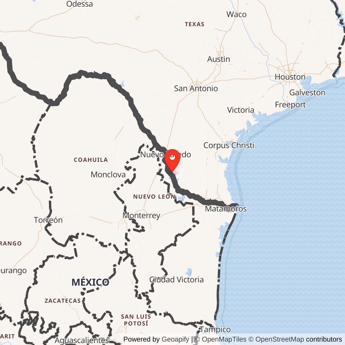
Longitude: -99.276111
Site Number: TM-189; 742nd AC&W Squadron; FUDS K06TX0645; FFID TX69799F674400
Location: Near Zapata, Zapata County, Texas
Site designation: TM-189
Unit: 742nd Aircraft Control
and Warning Squadron
Mission: Manual aircraft surveillance, warning and ground-controlled interception
Resident-unit
arrival: July 1, 1957
Documented radar service: May 1959 to August 1, 1960; squadron ended June 1, 1961
Representative
property-inventory coordinates: 26.952778 north, 99.276111 west. USACE FY2024 locator, not a surveyed antenna, boundary centroid or verified
entrance.
Principal parcel acreage: Approximately 41.25 acres for the two court-described tracts, excluding separate road and utility
interests; not the full station estate.
Overview
Zapata Air Force Station was a staffed Air Defense Command radar installation in southern Texas, near the Rio Grande. Its operational identity was TM-189, and its resident unit was the 742nd Aircraft Control and Warning Squadron. The squadron arrived on July 1, 1957, but the original ADC equipment chronology dates manual radar operation to May 1959. The station combined long-range aircraft search with a separate height finder and supported remote low-altitude coverage at Laredo and Delmita. Radar operation ended on August 1, 1960. The squadron remained on the organizational record until June 1, 1961.
The station's short radar career contrasts with a lengthy and unusually well-documented property afterlife. It included barracks, support buildings and 27 family houses. After a 1961 surplus auction, a survey revealed that the Air Force had built most of the installation on land outside the tracts it had acquired. The purchaser sought rescission, and a 1966 Court of Claims decision described the construction, auction, title failure and attempted correction in considerable detail. Later records document residential reuse, an RV-park phase and a federal underground-tank project. Zapata therefore represents both a southern radar-network installation and a significant example of the difficulties of disposing of a developed military property.
Location and Coordinate Interpretation
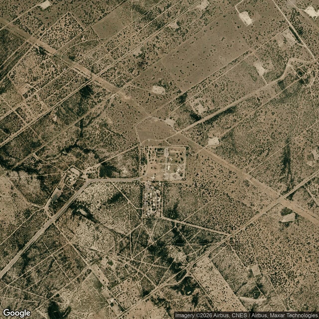
The former station is in Zapata County, near Zapata and the Rio Grande corridor. Its principal developed components were a larger operations and cantonment area and a smaller family-housing area. An original Air Force plan shows their relationship to access roads, utility facilities and the surrounding landscape. These components formed one station, not two separately identified radar installations. Its separate arrangement does not make the housing area a second radar installation.
Representative property-inventory coordinates are 26.952778 north, 99.276111 west, or latitude 26.952778 and longitude -99.276111. These are rounded from the USACE FY2024 FUDS feature, not surveyed antenna coordinates, a verified entrance or a property-boundary centroid. Scott D. Murdock's April 2003 visit used 26 degrees 57 minutes 09 seconds north and 99 degrees 16 minutes 32 seconds west. That nearby visit locator supports the general identification but should not be substituted for a precise deed or antenna position. The displayed decimal places do not confer survey accuracy.
Origins in the Third-Phase Radar Program
Zapata belonged to the third phase of ADC's Mobile Radar program. Searching the Skies explains that ADC requested this expansion on October 20, 1953, seeking additional coverage along the coasts and southern approaches. The concern included aircraft approaching around the ends of the existing network rather than passing through its better-covered sectors. The Air Force approved the program in January 1954. Its planned complement subsequently contracted from 25 stations to 21 in 1957. Those dates describe the national program, not an independently established local Zapata construction schedule.
The word mobile referred to the radar expansion program and equipment lineage, not to a community of buildings that routinely moved around Texas. Zapata required a permanent-looking compound with housing, water, roads, electrical generation and maintenance support. The time between authorization, unit activation, personnel arrival and radar operation illustrates how acquiring and constructing that infrastructure could take substantially longer than assigning a squadron number. Its eventual brief operating period was not evidence that the installation consisted only of portable radar trailers.
The official ADC organizational handbook places activation of the 742nd Aircraft Control and Warning Squadron at Oklahoma City Air Force Station on September 8, 1956. The squadron was assigned to the 33rd Air Division and moved to Zapata on July 1, 1957. Oklahoma City was thus the unit's initial organizational location as well as an important higher-headquarters setting. The 1957 arrival is a reliable local occupancy milestone. It is not an exact dedication date, construction acceptance date or proof that operational radar service began that day.
Acquisition, Construction and the Original Plan
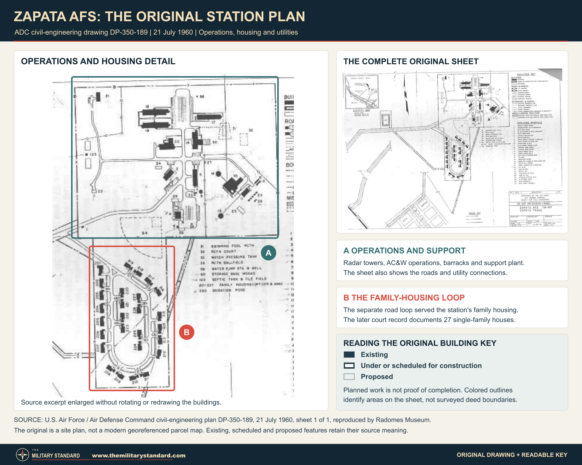
The later court opinion identifies the station's land as pasture belonging to Eduardo Villarreal and others in the Villarreal Ranch. In spring 1957, the government acquired two adjoining tracts through condemnation in the federal district court's Laredo Division. Tract A-100 contained 30 acres and measured 1,320 by 990 feet. Tract A-100-1 contained approximately 11.25 acres and measured 1,000 by 490 feet. Their common boundary was a 490-foot segment. Road and utility easements were additional interests, not simply extra buildings inside the two principal rectangles.
The pair totals approximately 41.25 acres. This is the combined area of the two principal tracts described in the litigation, not a verified total for every station land interest. A later FUDS synopsis reports approximately 100 acres acquired during 1955-1958. That broader number has a different apparent scope and comes from a secondary summary rather than the acquisition schedule itself. Both figures are useful when labeled correctly.
The original civil-engineering drawing, DP-350-189, is dated July 21, 1960. It identifies Zapata AFS as TM-189 and bears an ADC/33rd Air Division engineering title block. The drawing is more informative than a generic illustration of a radar station: it shows the larger compound in the upper part of the drawing, a separate housing-road arrangement below it, radar positions, access and utility connections. Its legend distinguishes existing work, work under construction or scheduled, and proposed facilities.
The plan includes positions labeled for FPS-3 and FPS-6 equipment, the aircraft-control and warning building, an electric-engine power plant, diesel storage and communications facilities. It also shows the barracks and officer accommodations, dining support, vehicle-related facilities, water infrastructure and recreation spaces. The court independently confirms that the developed larger parcel contained headquarters, school and recreation buildings, barracks, bachelor officers' quarters, dining and kitchen facilities and a water system. The two records together establish an installation designed to sustain a resident military community as well as electronic equipment.
The engineering title block's reference to the 33rd Air Division with SAGE wording does not establish that Zapata operated a SAGE data-transmission system. It identifies the drawing's headquarters context. Local operational evidence must come from the station record, and the original ADC table has a manual-operation entry but no SAGE-operation entry for Zapata. Likewise, transmitter and receiver facilities on the station plan do not by themselves establish a separately located remote Ground-Air Transmit-Receive site.
Manual Aircraft Warning and Control
ADC records place manual operation at Zapata in May 1959. The station's task was to detect and report aircraft and support ground-controlled interception within the continental air-defense system. Search radar supplied range and bearing information; the height finder supplied an additional altitude measurement. Personnel had to interpret the radar returns, coordinate the aircraft picture and convey information needed for identification and fighter control. That work depended on operators, controllers and communications support, not merely on an antenna turning above a tower.
Manual operation should not be confused with an absence of technology or with a lack of connection to a larger command network. It describes how the air-defense picture was handled at this station in the available record. General radar and ADC histories explain the operating architecture, but a complete Zapata shift instruction, traffic log or local interception report has not been recovered. Specific scrambles, named intercepted aircraft and measured local coverage envelopes therefore cannot be supplied responsibly from the general mission alone.
The 742nd was reassigned to the Oklahoma City Air Defense Sector on January 1, 1960. This was an organizational change during the station's brief operational period. It does not establish a new radar set, an AN/FST-2 digitizer or an automatic feed into an AN/FSQ-7 computer. The station should not be depicted as a completed SAGE radar merely because SAGE was expanding elsewhere or because the sector belonged to that broader defense environment. Its documented identity remains a manual aircraft-control and warning station.
Search Radar and Height Finding
The original ADC table lists AN/FPS-3A and AN/FPS-6 at Zapata in 1959. Its 1960 entry lists AN/FPS-3 and AN/FPS-6. Searching the Skies summarizes the station's initial equipment as FPS-3A and FPS-6. The civil-engineering plan uses FPS-3 for the search-radar position. This history retains that source sequence rather than inventing an equipment-replacement event to explain a change in suffix. The record establishes the FPS-3 family search radar and FPS-6 height finder, but not the date or physical mechanism of a change from a particular 3A set to a particular 3 set.
The later technical handbook describes the FPS-3 family as a fixed long-range search radar with moving-target-indication capability. Its rotating antenna supplied the horizontal search picture. The FPS-3A description identifies improvements to the earlier model, including transmitter-related changes, and gives a model frequency range of 1,220-1,365 MHz. These are reference characteristics of the equipment family. They do not demonstrate which frequency Zapata selected on a particular day, how many display consoles were installed locally or what range was achieved against a particular aircraft.
The FPS-6 performed a different job. It used an elevation-scanning antenna for height measurement in conjunction with search-radar information. Its presence explains why the station required two unlike radar positions rather than two equivalent search antennas. The search set established where to look in range and bearing; the height finder helped determine the target's vertical position. Neither a technical handbook published after the station closed nor a standard model specification is a local performance-test record. No later FPS-20, FPS-27 or other replacement search radar has been established at Zapata in the reviewed primary chronology.
Communications, Utilities and Daily Life
Electronic operations depended on a sizeable support plant. The original plan identifies power generation, diesel storage, water facilities and radio functions alongside the operational buildings. The court describes water, sewer and power systems and connecting roads, including facilities extending over nearby land. Those off-compound connections matter to the land story: an installation's functioning estate could involve access and utility rights beyond the acreage of its two most conspicuous developed parcels. They also help explain why disposing of buildings was not equivalent to conveying a single uncomplicated rectangle of vacant land.
Family housing was a particularly valuable part of the property. The court records 27 single-family houses, and the 1961 auction advertisement described three- and four-bedroom homes. Bachelor officers' quarters and barracks accommodated other residents, while the school, dining, recreation and water facilities supported everyday station life. These are actual locally documented features, not inferred additions from a standard ADC template. The house count should not be converted into a squadron strength or dependent population: no complete personnel return or household roster has been recovered.
The 1960 plan offers further detail about intended recreation and support arrangements, including spaces for activities that made a remote station more habitable. Its proposed-work symbols must still be respected. A planned swimming pool or playing area cannot be represented as a completed amenity merely because it appears on the sheet. There is also no verified local account here of every club, school program or maintenance shop. The useful distinction is between a demonstrable residential support community and an invented catalogue of activities that might have occurred at comparable stations.
Laredo and Delmita Gap-Filler Annexes
Zapata's equipment footprint extended through two separate remote annexes. The ADC gap-filler snapshot dated June 30, 1960, identifies Laredo as TM-189B, with AN/FPS-18 operation recorded in October 1959, and Delmita as TM-189A, with AN/FPS-18 operation recorded in April 1960. These were low-altitude search installations associated with the parent station, not additional FPS-6 height-finder sites. The original tables do not support substituting AN/FPS-14 for their documented FPS-18 equipment.
Gap fillers addressed portions of the low-altitude picture that a principal long-range radar could not adequately cover. The technical handbook describes FPS-18 equipment and the AN/FST-1 arrangement for conveying target-coordinate information to a distant heavy-radar station. That reference explains the architecture and why a remote search set could contribute to a staffed parent. It does not independently prove every local transmission, monitoring or generator component at these two annexes. No exact local circuit routing or complete component acceptance list has been recovered.
The annexes did not simply vanish from the network when Zapata stopped operating. In the ADC snapshot dated December 31, 1961, Laredo appears as TM-188C under the 733rd, with a December 1960 equipment entry. Delmita appears as TM-191C under the 813th, also with a December 1960 entry. Those records connect Laredo to Eagle Pass Air Force Station and Delmita to Rockport Air Force Station. They demonstrate changed parentage after Zapata's shutdown; the snapshot dates do not establish the precise day each transfer occurred.
These were separate installations with different missions. Laredo Gap Filler Annex was not Laredo Air Force Station's later tracking installation and was not Laredo Air Force Base. Carrizo Springs was an Eagle Pass annex, not a third Zapata annex established by the evidence here. Keeping the separate records avoids importing another station's radars, closure dates or property history into Zapata. It also permits a reader to follow the continuing annex network after the original TM-189 parent had ceased radar service.
Radar Shutdown and Squadron Discontinuance
Zapata's radar operation ended on August 1, 1960, according to the original ADC station chronology. Searching the Skies attributes its deactivation to budgetary constraints. Port Isabel Air Force Station, TM-190, is another southern Phase III station with the same radar-cessation date in the ADC table. These records place Zapata's withdrawal within a network reduction rather than establish a local equipment disaster or a combat-related closure. The specific local shutdown directive and complete closeout staffing schedule have not been recovered.
The 742nd's organizational ending came ten months later, on June 1, 1961. The ADC table calls this inactivation, while the official organizational handbook uses discontinuance. Both identify the same date and distinguish it from the operational radar stop. The later property-sale record introduces further dates: excess reporting and surplus declaration occurred before the May 1961 sale advertisement, deeds followed in September, and the title dispute continued for years. None of those later transactions extends radar operation beyond August 1960.
The Surplus Auction and Residential Opportunity
The court opinion establishes that the Air Force reported the installation excess and GSA declared it surplus before the public advertisement around May 4, 1961. The sale offered two items corresponding to the larger station parcel and the housing parcel. Its promotion emphasized 27 three- and four-bedroom houses and administrative buildings. Those houses made the property attractive for civilian occupation and resale even after the strategic purpose of the radar equipment had ended. The sale was not simply disposal of scrap antennas.
The auction took place at the Zapata County courthouse on June 19, 1961. Roy C. Rash submitted the high bids: $103,100 for the first item and $116,000 for the second, a combined $219,100. The initial cash payments totalled $43,820, with $175,280 represented by the two purchase-money notes. The remaining purchase price was to be paid in 40 quarterly instalments over ten years. These transaction figures describe the surplus sale, not the original government cost of constructing the radar station.
The government delivered two deeds on September 27, 1961. They retained the legal descriptions used in the condemnation proceedings and contained no warranty of title. Rash rented the houses while preparing for resale. The court describes his initial intention to hold the property for six months and his later attempt to sell the entire installation. When an early-1962 whole-property sale did not materialize, he decided in March to sell houses individually. This civilian plan depended on being able to convey the land beneath the houses, not just buildings whose locations appeared correct on an advertisement.
The Survey Error
The problem emerged when the Villarreal interests commissioned a survey and appraisal in connection with the original condemnation compensation. The government had acquired one pair of rectangles but developed a similarly arranged pair in a different position. According to the court's findings, only approximately seven acres of the acquired larger tract overlapped the larger developed parcel. None of the acquired smaller tract was used for the housing parcel. The station's buildings and improvements were therefore largely on ranch land the government did not own.
This was not merely a typographical mistake in a street address. The deeds described land that did not include much of what the purchaser understood he was buying. The court found that both the government and the ranch owners had been unaware of the mismatch before the 1962 survey. Rash learned of the problem about May 25, 1962, and suspended sales. Occupied houses and usable support buildings could not overcome uncertainty about the ground and rights required to convey them. The discovery undermined the principal residential value represented at auction.
Rash pursued a correction during June 1962, then sought a refund or a clear title and ultimately rescission. His attorney and Representative Joe M. Kilgore participated in the correspondence. Kilgore forwarded the request to GSA's administrator on July 2, placing the government on notice of the rescission demand. GSA maintained that the no-warranty terms limited the purchaser's claim, while proposing to amend the condemnation proceedings to acquire the land actually occupied. The resulting exchanges did not promptly restore a marketable residential property.
Attempted Correction and the 1966 Judgment
The government moved to amend its declaration of taking on November 21, 1962. The district court denied the motion on January 7, 1963. Separate arrangements with the Villarreal interests were completed about April 1, 1963. In May, the government tendered corrective deeds covering the developed 30-acre and approximately 11.25-acre parcels and their appurtenances. Rash refused them. The court found that the market had declined between the discovery of the defect in May 1962 and the tender in May 1963, during a period when he had been unable to execute the intended sales.
The litigation consequently concerned more than whether corrected paper could eventually be produced. It considered what had been offered, the mismatch between the offered improvements and the conveyed land, the purchaser's response after discovery and the delay in curing the problem. The Court of Claims' May 13, 1966, decision adopted the commissioner's findings with modifications and awarded Rash $89,285.80, conditional on returning possession and reconveying the interests conveyed by the 1961 deeds. The total included $70,583.07 in contract payments and an additional net expense recovery.
That conditional judgment is firm evidence of the legal outcome, but it is not itself the executed reconveyance instrument or proof of a particular transfer day. The later FUDS synopsis describes government reacquisition in 1966 and resale in 1968. The USACE inventory likewise records a 1966 excess phase and 1968 conveyance to local public and private interests. The synopsis identifies Zapata County, whereas the federal inventory's legacy narrative says the City of Zapata. Without the actual 1968 deeds, the governmental recipient should remain qualified rather than silently harmonized.
Environmental Project History
Federal environmental records identify the property as FUDS K06TX0645 and FFID TX69799F674400. GAO's 2001 publication, drawing on FY1999 project data, lists project 01 in the CON/HTRW category and at the remedial-design stage. This is a dated program snapshot, not evidence that all later work remained unfinished or that a particular contaminant was found at every building. CON/HTRW is the program's containerized hazardous, toxic and/or radioactive waste category. Its wording is not proof of radioactive contamination at Zapata.
A more specific record appears in the Army's September 23, 2009, RACER validation report. Its Zapata case study concerns a March 2004 Fort Worth District project, USACE-SWF-03, under contract order DACA63-01-D-0012-0011. The reviewed supporting-document list includes the February 17 proposal, March 2 statement of work, March 5 pricing, March 11 purchase request and March 31 order. The case study reports a project cost of $8,597. This amount belongs to the identified tank project, not the total lifetime cost of environmental work across the property.
The described work covered two 500-gallon underground storage tanks and associated vent, fill and other piping. Its scope included sampling and analysis of soil from all four sides and beneath each tank, purging and emptying, removal, backfilling, topsoil, seeding and mulching, and four copies of closure reports. The report discusses the project through UST closure/removal and residual-waste-management modelling. It is a retrospective contract-scope and cost-validation record. It is not the four underlying closure reports, a laboratory-results table or an independently reviewed regulatory clearance certificate.
The September 30, 2015, Texas FUDS inventory continues to list Zapata project 01 as CON/HTRW. The FY2024 geospatial inventory reports the property as eligible, with projects, and places it in the status category for properties with all projects at site closeout. It does not identify Zapata as a National Priorities List site. That structured status is important, but the same feature's narrative still says fuel-storage tanks remain to be removed. The older prose conflicts with both the dated tank-project record and the newer status field. It cannot responsibly be presented as an independently verified account of conditions in 2026.
The bounded conclusion is that a specific two-tank removal/closure project was documented for 2004 and that the FY2024 inventory reports project closeout. The actual closure reports, analytical results and regulatory signoff have not been obtained, so this history does not certify the whole property as uncontaminated or suitable for unrestricted use. April 1992 photographs include visible utility and tank structures, but an aboveground cylinder in a photograph is not identification of the two underground tanks in the later contract. Separate records must not be merged merely because each mentions tanks.
Civilian Reuse, Surviving Buildings and Access
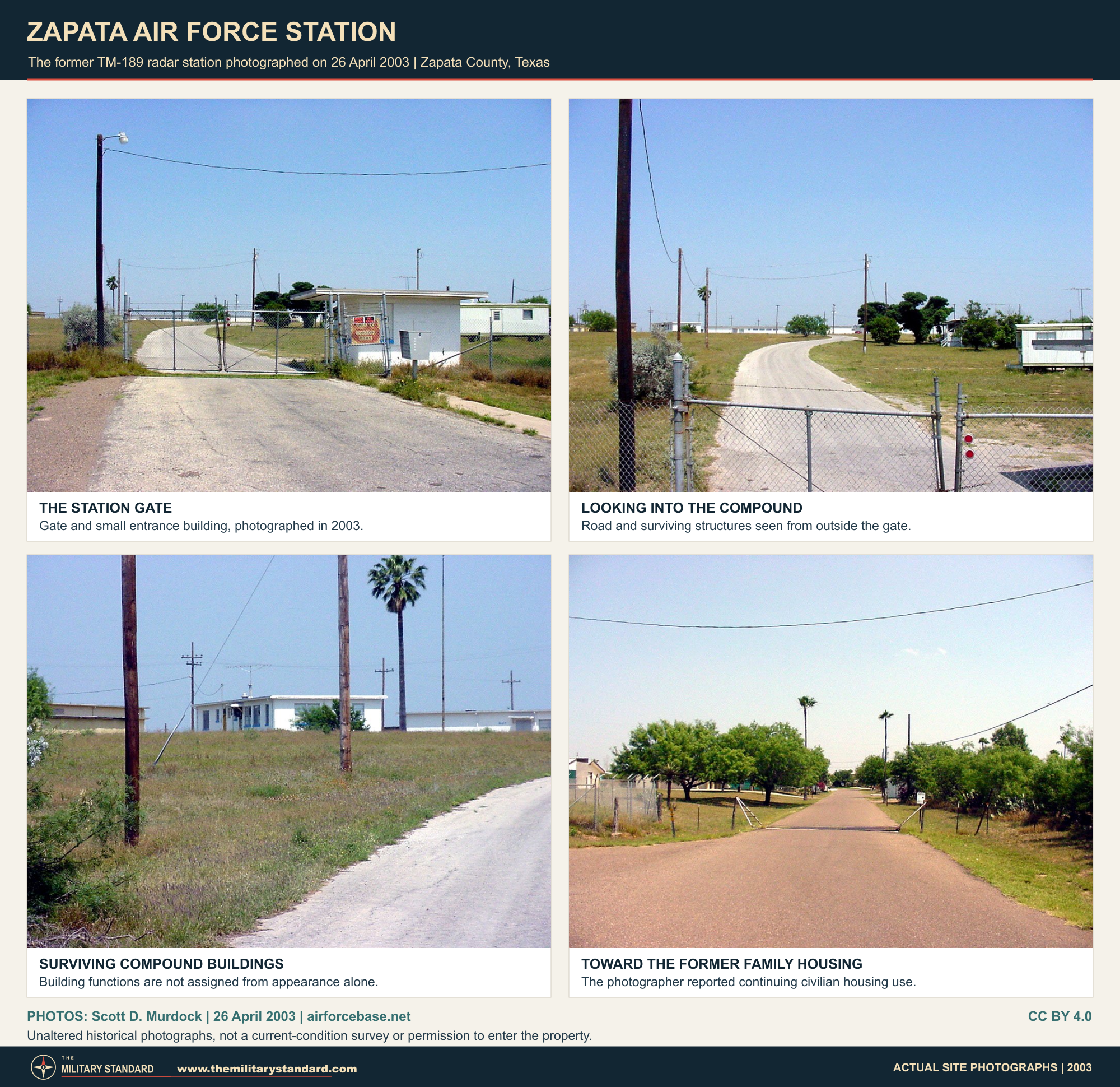
Photo credit: Scott D. Murdock, South Texas Field Trip, April 26, 2003. Creative Commons Attribution 4.0. Original photographs reproduced without retouching.
The early-1990s FUDS synopsis describes a Las Palmas RV-park phase, individual lots sold to winter residents and remaining land that was vacant or had reverted to the county. Its source date is given ambiguously as June 1992/3. The account is valuable evidence of a civilian property phase, but not a current ownership schedule. The accompanying April 1992 photographs were reproduced from a faxed FUDS document and are limited in detail. They establish dated remnants and surroundings, not a complete modern building inventory or precise contamination assessment.
Murdock visited on April 26, 2003, and observed from outside the fence that many station buildings remained reasonably intact. He also reported residential use of the former housing, with some properties empty and deteriorated and others maintained and landscaped. His photographs distinguish the former operational compound from the family-housing landscape. They demonstrate that the end of radar service did not entail immediate demolition of the entire station and that civilian occupancy could coexist with deteriorating military remnants.
The FY2024 Corps feature lists private ownership and residential use, but that inventory entry is neither a current deed search nor a 2026 field survey. A present owner of one parcel should not be assumed to own the entire former station. No current public-access permission, comprehensive structural survey or complete parcel-by-parcel ownership record has been verified here. Historical descriptions and old photographs do not authorize entry through a fence or into occupied housing. The site's best-supported survival account is therefore dated, with the latest federal inventory status clearly distinguished from direct observation.
Historical Significance and Remaining Research
Zapata illustrates the difference between a short-lived radar mission and a durable military-built landscape. Its family housing, school, utilities and support buildings were consequential assets even though the documented radar period lasted only from May 1959 to August 1960. Its annexes continued under other staffed stations, showing that withdrawal of a parent station could alter the network rather than remove every associated low-altitude radar. The original plan, equipment tables and unit lineage permit those technical and organizational changes to be reconstructed without assigning Zapata an unsupported SAGE phase.
The property litigation adds an unusually detailed record of construction and civilian disposal, including parcel dimensions, house counts, bids, payments and correction attempts. Environmental records then supply a separate tank-project chronology and a qualified closeout status. Important remaining research includes the original construction and acquisition schedules, squadron operating histories and strength returns, executed 1966/1968 transfer instruments, the four tank-closure reports and a contemporary building/deed survey. Those gaps are explicit limits on particular claims, not permission to omit the substantial operational, land, disposal and environmental evidence already available.
Chronology
- October 20, 1953 ADC requests the third-phase Mobile Radar expansion for additional coastal and southern coverage.
- January 1954 The Air Force approves the third-phase program; this is a program date, not Zapata construction acceptance.
- September 8, 1956 The 742nd Aircraft Control and Warning Squadron activates at Oklahoma City Air Force Station under the 33rd Air Division.
- Spring 1957 The government condemns two principal Villarreal Ranch tracts and associated interests for Zapata AFS.
- July 1, 1957 The 742nd moves to Zapata; resident-unit arrival precedes documented radar operation.
- May 1959 ADC records manual radar operation at TM-189.
- 1959 The original ADC table lists AN/FPS-3A search radar and AN/FPS-6 height finding.
- October 1959 ADC records AN/FPS-18 operation at Laredo Gap Filler Annex, TM-189B.
- January 1, 1960 The 742nd is reassigned to the Oklahoma City Air Defense Sector.
- April 1960 ADC records AN/FPS-18 operation at Delmita Gap Filler Annex, TM-189A.
- June 30, 1960 The dated ADC gap-filler snapshot lists the original TM-189A and TM-189B annex identities.
- 1960 The Zapata equipment table uses AN/FPS-3 and AN/FPS-6; a physical replacement event is not independently established.
- July 21, 1960 ADC civil-engineering drawing DP-350-189 records the station layout and distinguishes existing, scheduled and proposed work.
- August 1, 1960 Radar operation at Zapata ceases; Port Isabel has the same operational-ending date.
- December 1960 Later ADC equipment entries associate Laredo with TM-188C/733rd and Delmita with TM-191C/813th; exact transfer days are unresolved.
- Before May 4, 1961 The Air Force reports the station excess and GSA declares it surplus, according to the court's findings.
- About May 4, 1961 GSA advertises the surplus station, including 27 three- and four-bedroom houses.
- June 1, 1961 The 742nd is inactivated/discontinued, distinct from the August 1960 radar shutdown.
- June 19, 1961 Roy C. Rash wins the two auction items for a combined $219,100 at the Zapata County courthouse.
- September 27, 1961 The government delivers two deeds retaining the original condemnation descriptions.
- December 31, 1961 ADC's later gap-filler snapshot documents Laredo under the 733rd and Delmita under the 813th.
- March 1962 Rash turns from an unsuccessful whole-property sale attempt to planned sales of individual houses.
- About May 25, 1962 Rash learns that much of the developed installation lies outside the acquired land and suspends sales.
- July 2, 1962 Representative Joe M. Kilgore forwards the rescission request to GSA's administrator.
- November 21, 1962 The government moves to amend its declaration of taking.
- January 7, 1963 The district court denies that amendment motion.
- About April 1, 1963 The government completes separate arrangements with the Villarreal interests for the developed property.
- May 1963 Corrective deeds are tendered and refused after the period of impaired saleability and market decline.
- May 13, 1966 The Court of Claims awards $89,285.80 conditional on return of possession and reconveyance.
- 1966 The later FUDS synopsis reports government reacquisition; the exact executed transfer date is not established here.
- 1968 FUDS accounts report renewed disposal to local public and private interests; City-versus-County recipient wording conflicts.
- April 1992 Dated FUDS photographs document former-station remnants; the related reuse synopsis is labelled June 1992/3.
- FY1999 GAO's later published dataset records Zapata project 01 at remedial design in the CON/HTRW category.
- April 26, 2003 Scott D. Murdock photographs the former station and observes mixed-condition civilian housing from outside the fence.
- March 2004 The documented Fort Worth District project covers two 500-gallon underground tanks, piping and closure-related work.
- September 23, 2009 The RACER validation report publishes the retrospective Zapata tank-project case study.
- September 30, 2015 The Texas FUDS inventory lists Zapata project 01 in the CON/HTRW category.
- FY2024 USACE reports all projects at site closeout, while retaining conflicting older tanks-remain narrative text.
Information sources (15)
- PDFADC Historical Data, 1946-1973, Aerospace Defense Command
SOURCE FOR: Original station table printed page 56/PDF page 89, Zapata manual opening, FPS-3A/FPS-3 and FPS-6 entries, radar stop and unit ending; gap-filler snapshots printed pages 78 and 87/PDF pages 113 and 122, annex equipment, parentage and dated entries; Port Isabel parallel chronology.
- PDFA Handbook of Aerospace Defense Organization, 1946-1980
SOURCE FOR: Printed page 101/PDF page 112, 742nd activation, July 1, 1957 move to Zapata, command assignments and June 1, 1961 discontinuance; separate 811th lineage checked for the related Port Isabel record.
- PDFSearching the Skies: The Legacy of the United States Cold War Defense Radar Program, David F. Winkler, Air Combat Command, June 1997
SOURCE FOR: Phase III authorization and reduction context, manual air-defense architecture, Zapata site entry on printed page 157/PDF page 167, 1959 radar equipment and budget-related deactivation; public mirror of the USAF-authored report reviewed.
- WEBZapata AFS TM-189 Site Plan, DP-350-189, July 21, 1960, ADC Civil Engineering
SOURCE FOR: Original drawing of operations, radar positions, cantonment, housing, utilities and access; construction-status legend and headquarters title block, not an as-built certificate or surveyed deed reconstruction.
- WEBRoy C. Rash v. United States, 360 F.2d 940, 175 Ct. Cl. 797, May 13, 1966
SOURCE FOR: Full court opinion and adopted findings on 1957 acquisition, parcel dimensions, built facilities and 27 houses, 1961 sale and deeds, survey error, attempted correction, litigation and conditional $89,285.80 judgment.
- WEBUSACE Formerly Used Defense Sites, FY2024 Property Inventory, Zapata Query
SOURCE FOR: K06TX0645 and FFID TX69799F674400, representative coordinates, eligible/private-residential inventory entries, 1966/1968 legacy disposal narrative, all-projects-closeout status, NPL field and internally conflicting tanks-remain description; not a current deed or 2026 inspection.
- PDFFinal Validation Report Version 3.0 for RACER Services and Verification and Validation, U.S. Army Environmental Command, September 23, 2009
SOURCE FOR: Zapata USACE-SWF-03 case study, printed page 113/PDF page 117, March 2004 two-500-gallon-UST project scope, supporting-document dates and $8,597 cost. Complete archived WBDG PDF reviewed; not the underlying closure reports or regulatory signoff.
- WEBGAO-01-1012SP, Environmental Contamination: Cleanup Actions at Formerly Used Defense Sites, Texas Project Data, 2001
SOURCE FOR: FY1999 Zapata project 01, CON/HTRW classification and remedial-design status; historical program snapshot, not later completion certification.
- PDFFormerly Used Defense Sites Per State, Texas, September 30, 2015, USACE
SOURCE FOR: Zapata K06TX0645 project 01 CON/HTRW entry and dated continued program listing; category wording not proof of radioactive contamination.
- WEBZapata AFS FUDS Fact Synopsis, Radomes Museum
SOURCE FOR: Secondary account labelled June 1992/3, approximately 100-acre acquisition summary, 1966 reacquisition, 1968 resale and dated Las Palmas RV-park/lot reuse; County recipient wording differs from the USACE legacy description.
- WEBSouth Texas Field Trip, Scott D. Murdock, April 2003
SOURCE FOR: April 26 Zapata observations, visit locator, surviving buildings and mixed-condition occupied housing; dated photographs, not present-day title or permission to enter. Author's text and images CC BY 4.0 unless otherwise noted.
- WEBZapata AFS Recent-Photo Collection, Radomes Museum
SOURCE FOR: April 1992 FUDS photographs reproduced from faxed documents and their provenance; low-resolution images not used as a complete inventory or tank identification.
- PDFTM 11-487C-1 / MIL-HDBK-162A, Volume 1, United States Radar Equipment, December 15, 1965
SOURCE FOR: FPS-3/3A family reference characteristics, FPS-6 height-finding function and FPS-18/FST-1 gap-filler architecture; post-closure model context distinguished from verified local equipment acceptance.
- WEBZapata AFS View from the Gate, April 26, 2003, Scott D. Murdock
SOURCE FOR: Original 08.JPG photograph used in the approved photographic-record graphic, showing the road and buildings from the gate. Source-page CC BY 4.0 attribution retained near the graphic.
- WEBCreative Commons Attribution 4.0 International
SOURCE FOR: Reuse license for the Scott D. Murdock photographs; photographer, date, source and license links retained near the image.